Battery Rock Sandstone Member
Lithostratigraphy: Raccoon Creek Group >>Caseyville Formation >>Battery Rock Sandstone Member
Chronostratigraphy: Paleozoic Erathem >>Pennsylvanian Subsystem >>Morrowan Series
Allostratigraphy: Absaroka Sequence
Primary source
Nelson, W.J., P.H. Heckel and J.M. Obrad, 2022, Pennsylvanian Subsystem in Illinois: Illinois State Geological Survey, Bulletin (in press).
Contributing author(s)
W.J. Nelson
Name
Original description
Cox (1875, p. 204) wrote, “In Hardin County, below the mouth of the Saline River, and opposite the town of Caseyville, in Kentucky, the Conglomerate rises into a vertical wall known as the ‘Battery-rock,’ and forms here the western bank of the Ohio River.” As Cox (1875) described the “conglomerate,” it is 110 ft (33 m) thick, having a thin layer of shale and coal 50 ft (15 m) below the top and 180 ft (55 m) above river level. However, Cox (1875) did not actually name the “conglomerate” or trace it beyond the “type locality.”
Derivation
Battery Rock is a bluff overlooking the Ohio River in Hardin County, Illinois. During the Civil War, the Union Army placed cannons here, commanding the river (Sneed 1977).
Other names
The lower part of Lamar’s (1925) Lick Creek sandstone is believed to be the Battery Rock (Nelson and Weibel 1996).
History/background
Although Owen (1856, No. 1 vertical diagram) introduced the name “Battery Rock coal,” no usage of “Battery Rock sandstone” older than J.M. Weller (1940) has become known. Neither Glenn (1912) nor Lee (1916) used the term in their discussions of the Caseyville type area. In his lengthy treatise on the geology of Hardin County, Stuart Weller (1920, p. 226) alluded only to “the massive cliff-making sandstone at Battery Rock landing.” Butts (1925, p. 40) used the same construction in discussing the geology of the Equality–Shawneetown area. Wanless (1939), who was exceptionally thorough in describing named Pennsylvanian units, did not name the sandstone, although he, like all the preceding authors, mentioned the Battery Rock coal.
For his part, Weller (1940, p. 37) named the Battery Rock formation and described it as comprising the Battery Rock sandstone below and the Drury shale above. Wanless (1956, p. 5) used “Battery Rock (Lick Creek) sandstone or conglomerate” in the lower part of the Battery Rock cyclothem. Kosanke et al. (1960) established the present usage: Battery Rock Sandstone Member of Caseyville Formation.
In summary, Cox (1875) described the sandstone at what became the type locality, Weller (1940) named it informally, and Kosanke et al. (1960) named it formally. The long-disused name “Lick Creek sandstone” assigned by Lamar (1925) actually has priority over “Battery Rock sandstone.”
Type section

Type location
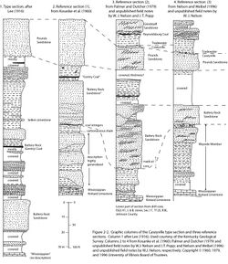
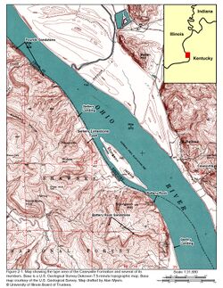
The type section is at the namesake bluff in sec. 27, T11S, R10E, Hardin County, Illinois, and is part of the Caseyville type section (Figures 2-1 and 2-2).
Type author(s)
Lee (1916).
Type status
The bluff shows the sandstone well, but contact relationships are obscured. Lee’s (1916) description does not agree well with that by Cox (1875).
Reference sections
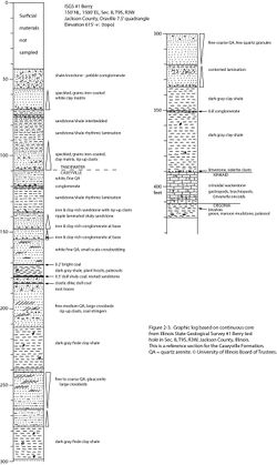
See reference sections for the Caseyville Formation (Figures 2-2 and 2-3).
Stratigraphic relationships
The Battery Rock has been mapped extensively along the outcrop in southern Illinois, leading to the notion that this is a nearly continuous, tabular sand body of fixed stratigraphic position. However, comparison of the type and reference sections of the Caseyville Formation (Figure 2-2) raises doubts about the continuity of the unit. The interval between the Pounds and Battery Rock Sandstones at the type section is 315 ft (95 m), compared with a range of 33 to 110 ft (10 to 33 m) in the three reference sections. Keeping in mind that the Caseyville stratotype contains the type Battery Rock, the interval here is greater than almost anywhere else in the basin. Aside from lateral tracing of sand bodies, the geologist has no a priori method to identify the Battery Rock in a given outcrop or well. The second prominent sandstone below the top of the Caseyville is usually labeled “Battery Rock,” but where sand bodies lens out, miscorrelations are likely. Vertical “stacking” of two or more valley-fill sandstone bodies also introduces potential miscorrelations.
Extent and thickness
In geologic quadrangle maps at scale 1:24,000, the Battery Rock has been mapped from Johnson County, near Interstate 57, eastward through parts of Pope, Hardin, and southern Saline and Gallatin Counties, Illinois. It has also been mapped in a few places across the Ohio River, in Kentucky (Trace and Amos 1984). The Battery Rock can be identified in well records a short distance north of the outcrop, but the unit has not been mapped systematically through the subsurface. As mapped, the Battery Rock ranges in thickness from a feather edge to more than 100 ft (30 m). Owing to the discontinuous nature of fluvial sandstone that fills paleovalleys, sandstone bodies of different ages probably have been mapped as “Battery Rock.”
Lithology
Like the younger Pounds Sandstone Member, the Battery Rock forms a widespread escarpment of bold, rounded cliffs. Large-scale, unidirectional planar and trough cross-bedding is prominent. Lenses of quartz-pebble conglomerate may occur throughout the member, not merely at the base. Among sandstones of the Caseyville, the Battery Rock tends to be the coarsest, and it contains the largest and most numerous quartz pebbles. Pebbles 1 inch (2.5 cm) in diameter or larger are common in the Battery Rock but are only locally found in older and younger strata. Near the top, the grain size becomes finer and the bed forms smaller.
Core(s)
Photograph(s)
Contacts
Contacts are seldom well exposed in the field. Where visible, the lower contact is commonly erosive. The upper contact may be sharp and planar to rolling, or it may be gradational from fine-grained, thinly bedded sandstone to siltstone or silty shale.
Well log characteristics
Typical for sandstone, the Battery Rock exhibits either an upward-fining profile or a nearly uniform “blocky” profile on resistivity logs.
Fossils
Casts of logs occasionally are present.
Age and correlation
On the basis of the palynology of coal beds, Peppers (1996) placed the Battery Rock well down in the Morrowan Series, approximately equivalent to the Kyrock Sandstone in western Kentucky and the Hindostan Whetstone in southern Indiana. The Battery Rock is likely to be correlative with the upper part of the New River Formation in West Virginia, the Middlesboro Sandstone in the Cumberland Gap area, and (by interesting coincidence) the Bee Rock Sandstone elsewhere in eastern Kentucky (S.F. Greb, Kentucky Geological Survey, written communication, 2017).
Environments of deposition
Like other thick, pebbly sandstone of the Caseyville, the Battery Rock is believed to be largely fluvial sediment filling southwest-trending incised valleys. The upper part of the Battery Rock may transition into estuarine facies.
Economic importance
The Battery Rock Sandstone serves as a scenic backdrop for recreation in the Shawnee National Forest and various state parks. From the 1810s to the 1850s, commercially carved gravestones and millstones were made from Battery Rock sandstone. Many carved stones came from Millstone Bluff in Pope County (McNerney and Meyer 1994).
Remarks
If the unit labeled “Battery Rock Sandstone” in the type and reference sections (Figure 2-2) actually is the same sandstone, the tectonic subsidence rate must have been markedly greater at the type locality than elsewhere.
References
- Butts, C., 1925, Geology and mineral resources of the Equality–Shawneetown area: Illinois State Geological Survey, Bulletin 47, 76 p., 2 pls.
- Cox, E.T., 1875, Geology of Gallatin County: Geological Survey of Illinois, v. 6, p. 197–219.
- Glenn, L.C., 1912, A geological reconnaissance of the Tradewater River region, with special reference to the coal beds: Kentucky Geological Survey, Bulletin 17, 75 p., 1 pl.
- Kosanke, R.M., J.A. Simon, H.R. Wanless, and H.B. Willman, 1960, Classification of the Pennsylvanian strata of Illinois: Illinois State Geological Survey, Report of Investigations 214, 84 p., 1 pl.
- Lamar, J.E., 1925, Geology and mineral resources of the Carbondale Quadrangle: Illinois State Geological Survey, Bulletin 48, 173 p., 3 pls.
- Lee, W., 1916, Geology of the Shawneetown Quadrangle in Kentucky: Kentucky Geological Survey, Ser. 4, v. 4, part 2, 73 p.
- McNerney, M., and H. Meyer, 1994, Early pioneer gravestones of Pope County, Illinois: Carbondale, Illinois, American Kestral Books, 42 p.
- Nelson, W.J., and C.P. Weibel, 1996, Geology of the Lick Creek Quadrangle, Johnson, Union, and Williamson Counties, southern Illinois: Illinois State Geological Survey, Bulletin 103, 39 p., 1 pl.
- Owen, D.D., 1856, Report of the geological survey of Kentucky made during the years 1854 and 1855: The American Journal of Science. Ser. 2, v. 23, p. 272–276.
- Peppers, R.A., 1996, Palynological correlation of major Pennsylvanian (Middle and Upper Carboniferous) chronostratigraphic boundaries in the Illinois and other coal basins: Geological Society of America, Memoir 188, 111 p., correlation chart.
- Sneed, G.J., 1977, Ghost towns of southern Illinois: Royalton, Illinois, G.J. Sneed, 309 p.
- Trace, R.D., and D.H. Amos, 1984, Stratigraphy and structure of the Western Kentucky fluorspar district: U.S. Geological Survey, Professional Paper 1151-D, 41 p., 1:48,000.
- Wanless, H.R., 1939, Pennsylvanian correlations in the Eastern Interior and Appalachian coal fields: Geological Society of America, Special Paper 17, 130 p., 9 pls.
- Wanless, H.R., 1956, Classification of the Pennsylvanian rocks of Illinois as of 1956: Illinois State Geological Survey, Circular 217, 14 p.
- Weller, J.M., 1940, Geology and oil possibilities of extreme southern Illinois: Illinois State Geological Survey, Report of Investigations 71, 71 p.
- Weller, S., 1920, The geology of Hardin County: Illinois State Geological Survey, Bulletin 41, 416 p., 2 pls.
ISGS Codes
| Stratigraphic Code | Geo Unit Designation |
|---|---|

