Ullin Limestone
Lithostratigraphy: Mammoth Cave Limestone Megagroup >>Ullin Limestone
Chronostratigraphy: Paleozoic Erathem >>Mississippian Subsystem >>Valmeyeran Series
Allostratigraphy: Kaskaskia Sequence
Primary source
Willman, H. B., Elwood Atherton, T. C. Buschbach, Charles Collinson, John C. Frye, M. E. Hopkins, Jerry A. Lineback, and Jack A. Simon, 1975, Handbook of Illinois Stratigraphy: Illinois State Geological Survey Bulletin 95, 261 p.
Contributing author(s)
Elwood Atherton, Charles Collinson, and Jerry A. Lineback
Name
Original description
Ullin Limestone (Lineback, 1966, p. 29-34).
Derivation
Named for Ullin, Pulaski County, near which the type section was compiled.
Other names
History/background
Type section
Type location
The type section of the Ullin Limestone was compiled from three exposures (secs. 14, 21, and 22, 14S-1W), which have a total thickness of about 630 feet.
Type author(s)
Type status
Reference section
Reference location
Reference author(s)
Reference status
Stratigraphic relationships
The Ullin overlies the Fort Payne Formation, or the Borden, Springville, Warsaw, or Chouteau Formations where the Fort Payne is absent. It underlies the Salem Limestone and pinches out beneath it in western Illinois.
Extent and thickness
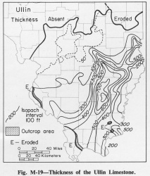
The Ullin Limestone maximum thickness is more than 800 feet in Hamilton County and it thins generally northward (fig. M-19). It is exposed in the Mississippi River bluffs in Monroe, St. Clair, and Madison Counties and in southern Illinois in Union, Pulaski, and Hardin Counties.
Lithology
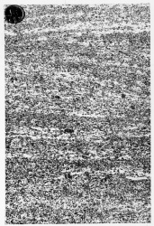
The Ullin Limestone is largely light-colored, fine- to coarse-grained limestone (fig. M-1F) that is rich in bryozoans and crinoids. The Ullin can generally be subdivided into two members, the Harrodsburg Limestone Member, above, and the Ramp Creek Limestone Member, below. The Harrodsburg is generally lighter colored, coarser grained, less cherty and less argillaceous than the Ramp Creek, whereas the Ramp Creek contains more crinoidal debris and is glauconitic in places. However, the Harrodsburg and Ramp Creek Members are similar in many places, and in about one-third of the area of the Ullin they cannot be differentiated. Where the Ullin is thickest, in Hamilton County, both members are light-colored calcarenite rich in bryozoans. Where the Ullin is thin, as it is on the crest of the Borden delta and on the highest parts of the Fort Payne tongue, both members become more crinoidal and are indistinguishable. The Ullin Limestone filled deepwater trenches bordered by depositional slopes of the Borden delta and the Fort Payne Formation.
Core(s)
Photograph(s)
Contacts
Well log characteristics
Fossils
Age and correlation
Environments of deposition
Economic importance
“Warsaw” is an informal name applied to producing zones in the Ullin Limestone.
Remarks
References
LINEBACK, J. A., 1966, Deep-water sediments adjacent to the Borden Siltstone (Mississippian) delta in southern Illinois: Illinois State Geological Survey Circular 401, 48 p.
ISGS Codes
| Stratigraphic Code | Geo Unit Designation |
|---|---|

