Potosi Dolomite
Lithostratigraphy: Knox Dolomite Megagroup >>Potosi Dolomite
Chronostratigraphy: Paleozoic Erathem >>Cambrian System >>Croixan Series >>Trempealeauan Stage
Allostratigraphy: Sauk Sequence
Primary source
Willman, H. B., Elwood Atherton, T. C. Buschbach, Charles Collinson, John C. Frye, M. E. Hopkins, Jerry A. Lineback, and Jack A. Simon, 1975, Handbook of Illinois Stratigraphy: Illinois State Geological Survey Bulletin 95, 261 p.
Contributing author(s)
T. C. Buschbach
Name
Original description
Potosi Dolomite (Winslow, 1894, p. 331, 351, 355).
Derivation
Named for Potosi, Washington County, Missouri.
Other names
History/background
In northern Illinois it was called Trempealeau (Workman and Bell, 1948) until the type Trempealeau was renamed "St. Lawrence" and "Trempealeauan" was used for the stage name. Potosi was then extended to northern Illinois (Buschbach, 1964).
Type section
Type location
Type author(s)
Type status
Reference section
Reference location
Reference author(s)
Reference status
Stratigraphic relationships
The Potosi Dolomite is a relatively pure dolomite overlying the sandstone and sandy dolomite of the Franconia Formation and underlying the sandy Eminence Formation. In the southern two-thirds of the state the Potosi is conformable with the Franconia below and the Eminence above, but in wide areas in northern Illinois it is unconformably overlain by the St. Peter Sandstone. Locally over the Ashton Arch the Eminence is absent and the Oneota overlies the Potosi.
Extent and thickness
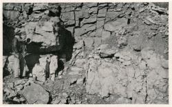
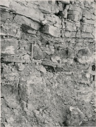
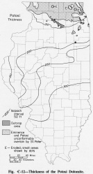
The Potosi Dolomite underlies essentially all of Illinois, except in parts of northern Illinois where it was truncated by the sub-Tippecanoe unconformity. It is exposed in the Oregon and Ashton areas in Ogle and Lee Counties (Willman and Templeton, 1951) (fig. Є-1A), where it is generally overlain by the St. Peter Sandstone. The exception is one exposure in Lee County, 4 miles south of Rochelle, Ogle County, where it is overlain by the Oneota Dolomite (fig. Є-1B). The Potosi ranges from 100 feet thick in northern Illinois to more than 300 feet in southern Illinois (fig. Є-12).
Lithology
It consists of finely crystalline, pure to slightly argillaceous, brown to pinkish gray dolomite that is very slightly glauconitic at the top and glauconitic and sandy at the base. Drusy quartz covers the surfaces of small cavities in most areas and characterizes the formation in both outcrops and well samples.
Core(s)
Photograph(s)
Contacts
Well log characteristics
Fossils
The Potosi contains algal domes and rare trilobite and gastropod remains.
Age and correlation
The Potosi is equivalent to the St. Lawrence Dolomite in Wisconsin (Ostrom, 1967), Michigan (Catacosinos, 1973), and Minnesota (Stauffer and Thiel, 1941) and to the Trempealeau Dolomite in Indiana (Gutstadt, 1958a).
Environments of deposition
Economic importance
Remarks
References
BUSCHBACH, T. C., 1964, Cambrian and Ordovician strata of northeastern Illinois: Illinois State Geological Survey Report of Investigations 218, 90 p.
CATACOSINOS, P. A., 1973, Cambrian lithostratigraphy of Michigan Basin: American Association of Petroleum Geologists Bulletin, v. 57, p. 2404-2418.
GUTSTADT, A. M., 1958a, Cambrian and Ordovician stratigraphy and oil and gas possibilities in Indiana: Indiana Geological Survey Bulletin 14, 103 p.
OSTROM, M. E., 1967, Paleozoic stratigraphic nomenclature for Wisconsin: Wisconsin Geological and Natural History Survey Information Circular 8, 1 p.
STAUFFER, C. R., and G. A. THIEL, 1941, Paleozoic and related rocks of southeastern Minnesota: Minnesota Geological Survey Bulletin 29, 261 p.
WILLMAN, H. B., and J. S. TEMPLETON, 1951, Cambrian and Lower Ordovician exposures in northern Illinois: Illinois Academy of Science Transactions, v. 44, p. 109-125; Illinois State Geological Survey Circular 179, 1952.
WINSLOW, ARTHUR, 1894, Lead and zinc deposits-Part 1: Missouri Geological Survey, v. 6, 387 p.
WORKMAN, L. E., and A. H. BELL, 1948, Deep drilling and deeper oil possibilities in Illinois: American Association of Petroleum Geologists Bulletin, v. 32, p. 2041-2062; Illinois State Geological Survey Report of Investigations 139.
ISGS Codes
| Stratigraphic Code | Geo Unit Designation |
|---|---|


