Mattoon Formation
Lithostratigraphy: McLeansboro Group >>Mattoon Formation
Chronostratigraphy: Paleozoic Erathem >>Pennsylvanian Subsystem >>Missourian Series
Allostratigraphy: Absaroka Sequence
Primary source
Willman, H. B., Elwood Atherton, T. C. Buschbach, Charles Collinson, John C. Frye, M. E. Hopkins, Jerry A. Lineback, and Jack A. Simon, 1975, Handbook of Illinois Stratigraphy: Illinois State Geological Survey Bulletin 95, 261 p.
Contributing author(s)
M. E. Hopkins and J. A. Simon
Name
Original description
The Mattoon Formation of the McLeansboro Group (Kosanke et al., 1960, p. 39, 40).
Derivation
Named for Mattoon, Coles County, which lies in the general outcrop area of the formation.
Other names
History/background
Type section
Type location
No type section has been designated, but a good reference section of the lower 300 feet of the formation is available in a detailed sample study and an electrical log for the Illinois Geological Survey Coal Section control well 191, an oil test boring in Clay County (SE SE SE 10, 4N-5E) on file at the Survey (Kosanke et al., 1960, p. 40, 83, 84).
Type author(s)
Type status
Reference section
Reference location
Reference author(s)
Reference status
Stratigraphic relationships
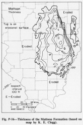
The Mattoon Formation of the McLeansboro Group is the youngest Pennsylvanian formation in Illinois. The formation is underlain by the Bond Formation (fig. P-2), and the top is an erosional surface overlain, for the most part, by Pleistocene glacial deposits.
Extent and thickness
A maximum of slightly more than 600 feet of Mattoon is preserved in the central part of the Illinois Basin in Jasper County (fig P-16).
Lithology
Lithologically the Mattoon Formation is a complex unit of thin limestones, coals, black fissile shales, underclays, thick gray shales, and several well developed sandstones. Outcrops are widely scattered, and reliable subsurface data, except for electrical logs of oil tests, are scarce. Consequently, the lateral extent of many of the named units has not been determined. However, many of the coals and limestone units in the Mattoon are believed to be no less persistent than others in the McLeansboro Group. The Omega and Greenup Limestone Members are well developed and contain abundant marine fossils, but others are thin and argillaceous. A few tan argillaceous limestones, which contain only ostracodes and Spirorbis, are usually less than 5 feet thick. The lower 150 feet of the Mattoon extends into Indiana.
Core(s)
Photograph(s)
Contacts
Well log characteristics
Fossils
Age and correlation
The Mattoon correlates with the upper part of the Sturgis Formation in western Kentucky but the top several hundred feet of the Sturgis is younger than the youngest Mattoon of Illinois.
Environments of deposition
Economic importance
Remarks
References
KOSANKE, R. M., J. A. SIMON, H. R. WANLESS, and H. B. WILLMAN, 1960, Classification of the Pennsylvanian strata of Illinois: Illinois State Geological Survey Report of Investigations 214, 84 p.
ISGS Codes
| Stratigraphic Code | Geo Unit Designation |
|---|---|

