Historical:Modesto Formation
Lithostratigraphy: McLeansboro Group >>Modesto Formation
Chronostratigraphy: Paleozoic Erathem >>Pennsylvanian Subsystem >>Desmoinesian Series >>Missourian Series
Allostratigraphy: Absaroka Sequence
Authors
M. E. Hopkins and J. A. Simon
Name Origin
The Modesto Formation of the McLeansboro Group (Kosanke et al., 1960, p. 36, 48, 67-70) is named for Modesto, Macoupin County.
Type Section
Modesto is near which four outcrops described by Payne (1942) and Ball (1952) constitute the type locality and expose nearly all the formation (SW SE 35, 10N-7W and NE NW 2, 9N-7W; W 1/2 NE NW 35, 10N-7W; SW SW SE 7, 12N-8W to NE SE SW 1, 12N-9W; and NE SW SW 16 to NE 17, 12N-9W).
Correlation
The Modesto Formation correlates with the Shelburn Formation and the overlying Patoka Formation of Indiana and a portion of the Sturgis Formation of western Kentucky.
Extent and Thickness
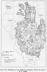
The Modesto Formation thickens from less than 125 feet along the La Salle Anticlinal Belt in east-central Illinois to over 200 feet in northern Illinois and over 450 feet in southern Illinois, averaging about 350 feet (fig. P-14).
Stratigraphic Position
The Modesto Formation includes strata from the top of the Danville (No. 7) Coal to the base of the Shoal Creek Limestone Member or the La Salle Limestone Member (fig. P-2). It is overlain by the Bond Formation and underlain by the Carbondale Formation.
Description
It consists of sediments somewhat similar to those of the underlying Carbondale Formation, but the coals are thinner, the limestones are generally thicker and less argillaceous, and several red claystones and shales are associated with the open-marine limestones. With the exception of the Lonsdale, Piasa, and West Franklin Limestones, most of the limestones of this formation, however, are thin and argillaceous. Even though the coals are thin, many are widespread. The sandstones in places are thick channel deposits up to 80 feet thick. Gray shales in this formation are particularly thick and constitute by far the greater part of the formation.
References
BALL, J. R., 1952, Geology and mineral resources of the Carlinville Quadrangle: Illinois State Geological Survey Bulletin 77, 110 p.
KOSANKE, R. M., J. A. SIMON, H. R. WANLESS, and H. B. WILLMAN, 1960, Classification of the Pennsylvanian strata of Illinois: Illinois State Geological Survey Report of Investigations 214, 84 p.
PAYNE, J. N., 1942, Structure of Herrin (No. 6) coal bed in Macoupin County, eastern Jersey and Greene, southeastern Scott, and southern Morgan and Sangamon Counties: Illinois State Geological Survey Circular 88, 46 p.
ISGS Codes
| Stratigraphic Code | Geo Unit Designation |
|---|---|


