Historical:McNairy Formation
Lithostratigraphy: Embayment Megagroup >>McNairy Formation
Chronostratigraphy: Mesozoic Erathem >>Cretaceous System >>Gulfian Series
Authors
H. B. Willman and John C. Frye
Name Origin
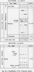
The McNairy Formation (Stephenson, 1914, p. 18, 22) (fig. K-2) is named for McNairy County, Tennessee.
Type Section
The type section is a railroad cut 1.5 miles west of Cypress Station in McNairy County, Tennessee.
Other Names
It was formerly called a member of the Ripley Formation (Lamar and Sutton, 1930) but was designated a formation by Pryor (1960).
Extent and Thickness
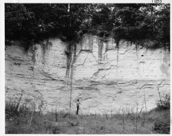
The McNairy is widely exposed in extreme southern Illinois, largely south of the Cache River Valley in Massac and Pulaski Counties but also farther west in the southern part of the hills from Olive Branch to Fayville in Alexander County (fig. K-1A). The lower part of the formation is widely exposed in roadcuts in the hills 2-4 miles north of Unionville, Massac County (Ross, 1964), and the upper part in the Ohio River bluffs in the vicinity of U.S. Dam 53 in Pulaski County (Pryor and Ross, 1962). The formation is at least 450 feet thick, perhaps locally a little thicker. Along its northern limit it is truncated by the Mounds Gravel.
Description
The McNairy Formation is a deltaic deposit at the northern end of the Mississippi Embayment and consists largely of nonmarine sand deposited by rivers and of lignitic clays and silts deposited in interdistributary areas. The lower part consists of fine, white to light gray, cross-bedded, micaceous sand. A middle section, which is gray to black silt with beds of lignite, is named the Levings Member. The upper part is similar to the lower. In the areas where the McNairy is overlain by the Mounds Gravel, the upper 25-50 feet is commonly stained red by iron oxide. South of Illinois, the McNairy Formation grades into the marine sediments of the Selma Formation.
References
LAMAR, J. E., and A. H. SUTTON, 1930, Cretaceous and Tertiary sediments of Kentucky, Illinois, and Missouri: American Association of Petroleum Geologists Bulletin, v. 14, p. 845-866.
PRYOR, W. A., 1960, Cretaceous sedimentation in upper Mississippi Embayment: American Association of Petroleum Geologists Bulletin, v. 44, p. 1473-1504; Illinois State Geological Survey Reprint 1960-J.
PRYOR, W. A., and C. A. ROSS, 1962, Geology of the Illinois parts of the Cairo, La Center, and Thebes Quadrangles: Illinois State Geological Survey Circular 332, 39 p.
ROSS, C. A., 1964, Geology of the Paducah and Smithland Quadrangles in Illinois: Illinois State Geological Survey Circular 360, 32 p.
STEPHENSON, L. W., 1914, Cretaceous deposits of the eastern Gulf region and species of Exogyra from the eastern Gulf regions and the Carolinas: USGS Professional Paper 81, 77 p.
ISGS Codes
| Stratigraphic Code | Geo Unit Designation |
|---|---|


