Historical:Cambrian System
Chronostratigraphy: Paleozoic Erathem >>Cambrian System
Author
T. C. Buschbach
Name Origin
The Cambrian System (Sedgwick, 1835, p. 390) is named for Cambria, the Roman name for northern Wales.
Type Section
The type section for the Cambrian System is well exposed in Cambria.
Extent and Thickness
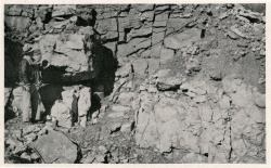
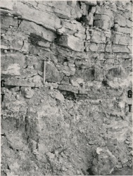
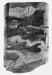
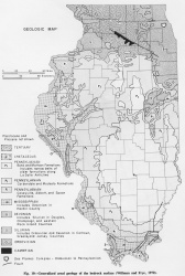
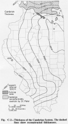
Cambrian strata underlie all of Illinois, but they are exposed only in relatively small areas in Ogle and Lee Counties (Bevan, 1935, 1939; Willman and Templeton, 1951) (fig. Є-1). However, they directly underlie thick glacial drift in a larger area in Lee and De Kalb Counties (Weller et al., 1945; Willman et al., 1967), where they occur on the south, or upthrown, side of the Sandwich Fault (fig. 10). Cambrian rocks range from about 1000 feet thick in southwestern Illinois to more than 3500 feet in the eastern part of the state (fig. Є-2).
|
Stratigraphic Position
All Cambrian sediments in Illinois are considered late Cambrian in age and are assigned to the Croixan Series. However, as the Mt. Simon Sandstone (at the base), which forms more than half the system in the northern two-thirds of the state, contains no fossils, middle and early Cambrian strata could be present even though not identifiable (Bell et al., 1964). The possibility that Precambrian sandstones also may be represented in the Mt. Simon Sandstone (Workman and Bell, 1948) seems less likely (Templeton, 1950).
The Cambrian System is differentiated from the overlying Ordovician in northern Illinois by both fossils and lithology, but in much of southern Illinois, where the contact is deeply buried and has been penetrated in only a few borings, Cambrian and Ordovician rocks consist of similar types of dolomite. Consequently, the boundary may occur within an interval of several hundred feet.
Description
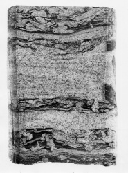
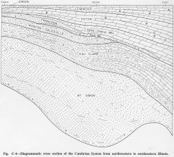
Cambrian strata in Illinois are dominantly sandstone, which is generally white but locally is stained or mottled red or yellow. The sand is subangular to well rounded, poorly to well sorted, and predominantly medium grained, although it varies from fine to coarse grained and some beds contain small quartz pebbles. Much of the sandstone is friable, dominantly quartz, and noncalcareous. The basal zone, as much as 350 feet thick, is strongly arkosic. In extreme northern Illinois the Cambrian System, although 90 percent sandstone, contains a persistent dolomite, the Potosi Dolomite (fig. Є-3). The Franconia Formation, the upper part of the Ironton Sandstone, and the Eau Claire Formation contain dolomitic sandstone. As these three units thicken southward and grade into dolomite, the proportion of sandstone diminishes to probably no more than 25 percent in extreme southern Illinois (fig. Є-4).
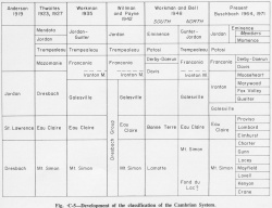
Classification of the Cambrian rocks in Illinois is based largely on classifications that developed in the late 1800s in the outcrop areas to the north in Wisconsin and Minnesota and to the southwest in Missouri, long before the few Cambrian outcrops in Illinois had been recognized. Deep drilling, primarily for ground water, in the Chicago area and later in scattered localities throughout the state, penetrated the Cambrian formations and permitted correlations with the outcrop areas (fig. Є-5). More recently, some units not present or not recognized in the outcrop areas have been differentiated in the very thick subsurface Cambrian sections in Illinois by studies of samples from borings (Templeton, 1950; Buschbach, 1964).
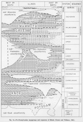
The dominantly sandstone units in the lower part of the Cambrian System are collectively called the Potsdam Megagroup (figs. 14, Є-3), and the upper dolomite units are referred to the Knox Dolomite Megagroup, which extends upward to include Ordovician dolomite formations. An interval of interbedded sandstone, siltstone, shale, and dolomite units separates the Potsdam and Knox Megagroups, except in southwestern Illinois (fig. Є-4).
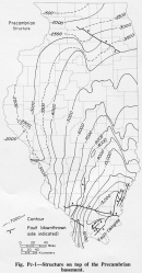
The Cambrian System rests with major unconformity (the sub-Sauk unconformity) (fig. 14) on Precambrian igneous rocks (fig. Pc-1), most of which are granite. The Precambrian surface is commonly referred to as a peneplain, but knobs of Precambrian rocks as much as 500-1000 feet high rise sharply into the Cambrian rocks (Workman and Bell, 1948; Atherton, 1971). Only a few such knobs are known in the Illinois Basin, most of them marginal to the Ozark region, but many others may exist.
The Cambrian System is generally separated from the overlying Ordovician System by a sharp change in lithology, but no erosional or structural evidence of an unconformity is apparent. Similar relations exist between rock-stratigraphic units within the Cambrian, but many have transitional contacts. The next higher major unconformity is the sub-Tippecanoe unconformity at the base of the St. Peter Sandstone or Everton Formation. Cambrian and Ordovician strata in the interval of relatively parallel units (fig. 14) between the sub-Tippecanoe unconformity and the basal Cambrian unconformity are referred to the Sauk Sequence.
Fossils
Fossils are scarce in Cambrian sediments, but the seas were not without life; trilobite debris forms black streaks in some beds. The fauna has not been intensively studied, but Raasch (Willman and Templeton, 1951) reported Dikelocephalus, Illaenurus, and Saukiella, as well as unnamed species of trilobites from the Franconia exposures at Oregon, Ogle County, and Cryptozoon, Hypseloconus, and Saukiella from outcrops of the Potosi Formation. Oboloid brachiopods, gastropods, algal domes, and worm borings also are present but poorly preserved. The fauna is much better known in Wisconsin (Twenhofel et al., 1935; Raasch, 1951), Minnesota (Bell et al., 1956), and Missouri (Lochman-Balk, 1956).
Depositional Environment
The sand that composes most of the Cambrian rocks in Illinois was derived almost entirely from the region to the north and was deposited in a marine embayment. The roundness of the grains and the presence of a suite of stable heavy minerals, limited both in variety and quantity, suggest that most of the sands were derived from Precambrian, or possibly early Cambrian, sandstones, which at that time probably covered a large area of the Canadian Shield. In some beds the more varied suite of heavy minerals typical of granitic terranes indicates occasional erosion by the rivers through the sandstones into the Precambrian granites, but the characteristics of most of the sands suggest they had passed through at least one and possibly several cycles of erosion, transportation, and deposition. The highly arkosic basal sandstone may have been derived from closer sources. In southwestern Illinois the sand probably came from the Ozark region, which was strongly dissected before late Cambrian time. In eastern and southern Illinois, beds of shale in the Cambrian strata appear to be continuous, have thicker units to the south and southeast, and were probably derived from Appalachian sources.
All the sandstones above the Mt. Simon, and possibly even the uppermost Mt. Simon, grade southward through dolomitic sandstone and sandy dolomite facies into dolomite that is relatively pure, except for some beds that contain chert, drusy quartz, and glauconite. The southward thickening of the dolomite and the lack of recognizable unconformities suggest the progressive sinking of the Illinois Basin during Croixan time. The bordering positive areas, and in fact much of the interior of the continent, were submerged by the seas during that time, and perhaps only the higher areas of the Canadian Shield remained as land.
References
ATHERTON, ELWOOD, 1971, Tectonic development of the Eastern Interior Region of the United States: Illinois State Geological Survey Illinois Petroleum 96, p. 29-43.
BELL, A. H., ELWOOD ATHERTON, T. C. BUSCHBACH, and D. H. SWANN, 1964, Deep oil possibilities of the Illinois Basin: Illinois State Geological Survey Circular 368, 38 p.
BELL, W. C., R. R. BERG, and C. A. NELSON, 1956, Croixan type area-upper Mississippi Valley, in El Sistema Cambrico, su paleogeografia y el problema de su base-symposium, Part 2: 20th International Geological Congress, p. 415-446.
BEVAN, A. C., 1935, Cambrian inlier at Oregon, Illinois: Kansas Geological Society Guidebook, 9th Annual Field Conference, p. 383-385.
BEVAN, A. C., 1939, Cambrian inlier in northern Illinois: American Association of Petroleum Geologists Bulletin, v. 23, p. 1561-1564.
BUSCHBACH, T. C., 1964, Cambrian and Ordovician strata of northeastern Illinois: Illinois State Geological Survey Report of Investigations 218, 90 p.
LOCHMAN-BALK, CHRISTINA, 1956, The Cambrian of the middle central interior states of the United States, in El Sistema Cambrico su paleogeografia y el problema de su base-symposium, Part 2: 20th International Geological Congress, p. 447-481.
RAASCH, G. O., 1951, Revision of Croixan dikelocephalids: Illinois Academy of Science Transactions, v. 44, p. 137-151 ; Illinois State Geological Survey Circular 179.
SEDGWICK, A., 1835 [abs.]: Edinburgh New Philosophical Journal, v. 19, p. 390.
SWANN, D. H., and H. B. WILLMAN, 1961, Megagroups in Illinois: American Association of Petroleum Geologists Bulletin, v. 45, p. 471-483; Illinois State Geological Survey Reprint 1961-N.
TEMPLETON, J. S., 1950, Mt. Simon Sandstone in northern Illinois: Illinois Academy of Science Transactions, v. 43, p. 151-159.
TWENHOFEL, W. H., G. O. RAASCH, and F. T. THWAITES, 1935, Cambrian strata of Wisconsin: Geological Society of America Bulletin, v. 46, p. 1687-1744.
WELLER, J. M., et al., 1945, Geologic map of Illinois: Illinois State Geological Survey.
WILLMAN, H. B., and J. C. FRYE, 1970, Pleistocene stratigraphy of Illinois, Illinois State Geological Survey Bulletin 94, 204 p.
WILLMAN, H. B., and J. S. TEMPLETON, 1951, Cambrian and Lower Ordovician exposures in northern Illinois: Illinois Academy of Science Transactions, v. 44, p. 109-125; Illinois State Geological Survey Circular 179, 1952.
WILLMAN, H. B., et al., 1967, Geologic map of Illinois: Illinois State Geological Survey.
WORKMAN, L. E., and A. H. BELL, 1948, Deep drilling and deeper oil possibilities in Illinois: American Association of Petroleum Geologists Bulletin, v. 32, p. 2041-2062; Illinois State Geological Survey Report of Investigations 139.
ISGS Codes
| Stratigraphic Code | Geo Unit Designation |
|---|---|
