Fort Payne Formation
Lithostratigraphy: Mammoth Cave Limestone Megagroup >>Fort Payne Formation
Chronostratigraphy: Paleozoic Erathem >>Mississippian Subsystem >>Valmeyeran Series
Allostratigraphy: Kaskaskia Sequence
Primary source
Willman, H. B., Elwood Atherton, T. C. Buschbach, Charles Collinson, John C. Frye, M. E. Hopkins, Jerry A. Lineback, and Jack A. Simon, 1975, Handbook of Illinois Stratigraphy: Illinois State Geological Survey Bulletin 95, 261 p.
Contributing author(s)
Elwood Atherton, Charles Collinson, and Jerry A. Lineback
Name
Original description
Fort Payne Formation (Smith, 1890, p. 155-156).
Derivation
Named for Fort Payne, De Kalb County, Alabama.
Other names
History/background
Type section
Type location
Type author(s)
Type status
Reference section
Reference location
Reference author(s)
Reference status
Stratigraphic relationships
The Fort Payne overlies the Springville Shale, the Chouteau Limestone, or the lower portion of the foreset slope of the Borden Siltstone delta in southern Illinois. It is overlain by the Ullin Limestone.
Extent and thickness
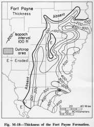
The Fort Payne is confined to southern Illinois. It is over 610 feet thick in Pope County, and thins northward and westward (fig. M-18). The best exposure of the Fort Payne in Illinois is in a fault slice along the Shawneetown Fault near the former community of Horseshoe, Saline County, where at least 150 feet of steeply dipping beds are exposed. The Fort Payne is also exposed on the flanks of Hicks Dome in Hardin County, where it is largely weathered to chert. Eleven feet of chert exposed in the bluff in Alexander County west of Ullin, Pulaski County, is also assigned to the Fort Payne.
Lithology
The Fort Payne consists of dark, very fine-grained, siliceous, cherty limestone. In the subsurface the Fort Payne consists of quartz and carbonates in silt- and clay-sized particles. In the lower part it contains nodular chert and fossils, especially crinoids, and some clay minerals. The dark color is caused by pyrite and organic matter. It is the northernmost extension of a large body of siliceous and cherty rocks that extends through western Kentucky to Mississippi and Alabama and eastward to the Appalachian Mountains.
Core(s)
Photograph(s)
Contacts
Well log characteristics
Fossils
Age and correlation
Environments of deposition
The Fort Payne occurs as an irregular tongue-shaped body that partially filled a deep-water basin bordered by the foreset slopes of the Borden delta in southern Illinois and southeastern Indiana (Lineback, 1966).
Economic importance
Remarks
References
LINEBACK, J. A., 1966, Deep-water sediments adjacent to the Borden Siltstone (Mississippian) delta in southern Illinois: Illinois State Geological Survey Circular 401, 48 p.
SMITH, E. A., 1890, Geological structure and description of the valley regions adjacent to the Cahaba coal field, in Report on the Cahaba coal field: Alabama Geological Survey, part 2, p. 137-180.
ISGS Codes
| Stratigraphic Code | Geo Unit Designation |
|---|---|
