Chouteau Limestone
Lithostratigraphy: Mammoth Cave Limestone Megagroup >>Chouteau Limestone
Chronostratigraphy: Paleozoic Erathem >>Mississippian Subsystem >>Kinderhookian Series
Allostratigraphy: Kaskaskia Sequence
Primary source
Willman, H. B., Elwood Atherton, T. C. Buschbach, Charles Collinson, John C. Frye, M. E. Hopkins, Jerry A. Lineback, and Jack A. Simon, 1975, Handbook of Illinois Stratigraphy: Illinois State Geological Survey Bulletin 95, 261 p.
Contributing author(s)
Elwood Atherton, Charles Collinson, and Jerry A. Lineback
Name
Original description
Chouteau Limestone (Swallow, 1855, p. 101).
Derivation
Named for Chouteau Springs, Cooper County, Missouri, where the name was applied to 70 feet of limestone between the "Encrinital Limestone" (Burlington) and the "Vermicular Sandstone" (Hannibal).
Other names
The name "Rockford," which was applied to the formation in Indiana, was used in southeastern Illinois until the older name, Chouteau, was accepted for all of Illinois (Buschbach, 1952).
History/background
Type section
Type location
Type author(s)
Type status
Reference section
Reference location
Reference author(s)
Reference status
Stratigraphic relationships
The Chouteau Limestone is the uppermost formation in the Kinderhookian Series. The Chouteau Limestone normally overlies the Hannibal Formation with apparent conformity, and in places the lower part grades laterally into the upper part of the Hannibal Shale, but in southwestern Illinois the Chouteau locally overlaps the Hannibal and lies unconformably on Devonian to Ordovician formations. In central and eastern Illinois the Chouteau is overlain by the Borden Siltstone, in western Illinois by the Burlington Limestone, in southwestern Illinois by the Meppen or Fern Glen Formations, and in Union County and vicinity by the Springville Shale (Buschbach, 1952).
Extent and thickness
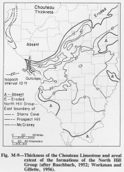
The Chouteau extends over almost all of Illinois south of a line from Calhoun County to northern Vermilion County (fig. M-9), but it is exposed only in Calhoun and Jersey Counties (Buschbach, 1952; Rubey, 1952; Collinson et al., 1954) and in a small area around Hicks Dome in Hardin County (Weller et al., 1952). It is well exposed in Pere Marquette State Park, southwestern Jersey County, and in the Meppen North Section, Calhoun County (SW NE 23, 12S-2W), where it is about 60 feet thick (Collinson, 1957, 1969). The Chouteau is generally less than 20 feet thick, but it thickens to nearly 80 feet in southern Calhoun County.
Lithology
The Chouteau consists of irregular beds of light brownish or greenish gray, lithographic to very fine-grained limestone with wavy bedding planes. The beds vary from a few inches to nearly 1 foot thick. Locally it is fine-grained dolomite. In a narrow belt extending northeastward from the Ozark region it is red or pink. Gray and buff chert nodules are present and locally abundant where the formation is more than 30 feet thick, but where it is less than 20 feet thick chert is absent. Geodes 1-8 inches in diameter and filled with calcite are common.
Core(s)
Photograph(s)
Contacts
Well log characteristics
Fossils
Macrofossils also are common and conodonts are present in nearly all beds (Collinson, 1961).
Age and correlation
Environments of deposition
Economic importance
Remarks
References
BUSCHBACH, T. C. , 1952, Chouteau Formation of Illinois: Illinois Academy of Science Transactions, v. 45, p. 108- 115; 1953, Illinois State Geological Survey Circular 183.
COLLINSON, CHARLES, 1957, Ordovician, Silurian, Devonian, and Mississippian rocks of western Illinois: Illinois Geological Society Guidebook, 24 p.
COLLINSON, CHARLES, 1961, Kinderhookian Series in the Mississippi Valley, in Northeastern Missouri and west-central Illinois: Kansas Geological Society Guidebook, 26th Annual Field Conference, Missouri Geological Survey Report of Investigations 27, p. 100-109; Illinois State Geological Survey Reprint 1961-U.
COLLINSON, CHARLES, 1969, Devonian-Mississippian biostratigraphy of northeastern Missouri and western Illinois: North American Paleontological Convention Field Trip 3, 23 p.
COLLINSON, CHARLES, D. H. SWANN, and H. B. WILLMAN, 1954, Guide to the structure and Paleozoic stratigraphy along the Lincoln Fold in western Illinois: Illinois State Geological Survey Guidebook Series 3, 75 p.
RUBEY, W. W., 1952, Geology and mineral resources of the Hardin and Brussels Quadrangles: USGS Professional Paper 218, 179 p.
SWALLOW, G. C., 1855, Geology of Missouri: Missouri Geological Survey 2nd Annual Report, p. 59-170.
WELLER, J. M., R. M. GROGAN, and F. E. TIPPIE, 1952, Geology of the fluorspar deposits of Illinois: Illinois State Geological Survey Bulletin 76, 147 p.
ISGS Codes
| Stratigraphic Code | Geo Unit Designation |
|---|---|
