Bucktown Coal Member (abandoned)
Lithostratigraphy: Carbondale Formation >>Bucktown Coal Member
Chronostratigraphy: Paleozoic Erathem >>Pennsylvanian Subsystem >>Desmoinesian Series
Allostratigraphy: Absaroka Sequence
Primary source
Nelson, W.J., P.H. Heckel and J.M. Obrad, 2022, Pennsylvanian Subsystem in Illinois: Illinois State Geological Survey, Bulletin (in press).
Contributing author(s)
W.J. Nelson
Name
Original description
Shaver et al. (1970, p. 27–28) published the first description of the Bucktown Coal Member. They attributed the name to C.E. Wier “in preparation,” but this manuscript was never published and no copy has been located. Wier (1961) did not discuss the Bucktown Coal.
Derivation
The coal took its name from Bucktown in Sullivan County, Indiana, near which it was mined. The origin of the town’s name is unknown.
Other names
As Shaver et al. (1986, p. 23–24) mentioned, previous authors variously referred to coal between the Springfield and Herrin in Indiana as Coal Va or Coal Vb. Records of two distinct coal seams within this interval are elusive and have not been confirmed by newer studies, except for highly localized “splitting” of the Briar Hill (Bucktown) by clastic layers.
Type section
Type location
Shaver et al. (1970) located the type section in abandoned strip mines about 1 mi (1.6 km) southeast of Bucktown in sec. 1, T 6 N, R 8 W, Sullivan County. They did not publish a description. Wier’s (1965) description, if he made one, has been lost.
Type author(s)
Shaver et al. (1970).
Type status
Unknown, but likely under water or buried by slumped debris.
Reference section
Reference location
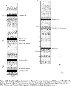
A core that illustrates the Bucktown in its type area is Peabody Energy’s borehole No. 15-H7, drilled 1,900 ft (579.1 m) from the north line, 2,150 ft (655.3 m) from the west line, sec. 15, T 6 N, R 8 W, Sullivan County. John Nelson of the ISGS logged the core in 2008. As shown on the graphic log (Figure 4-69), the Bucktown is 3.7 ft (1.13 m) thick and occurs in the depth range of 236.0 to 239.7 ft (71.9 to 73.1 m). This core clearly establishes the position of the Bucktown relative to the Springfield Coal below and the position of the Herrin Coal above. The position of the Herrin is at the truncated underclay underlying the black, phosphatic Anna Shale and Hymera Coal Members.
Reference author(s)
This report.
Reference status
The ISGS did not acquire the core. The log is on file at the Geological Records Unit of the ISGS and is available via the ISGS website.
Stratigraphic relationships
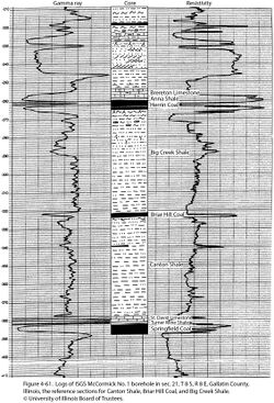
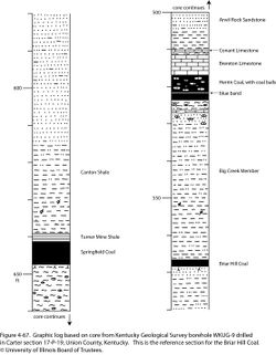
Direct comparison of the Bucktown reference core (Figure 4-69) with the Briar Hill reference sections (Figures 4-61 and 4-67) demonstrates that the coal members are the same. Salient points include (1) the position of the Briar Hill and Bucktown above the St. David Limestone, (2) the weakly developed paleosol beneath the Briar Hill and Bucktown, (3) the absence of marine limestone and black shale above the Briar Hill and Bucktown, and (4) the upward-coarsening clastic succession that separates the Briar Hill and Bucktown from the Herrin Coal (or its position). Given that the name Briar Hill (Glenn 1912) enjoys priority over Bucktown (Shaver et al. 1970), the name Bucktown is redundant and is hereby abandoned.
As a further note, Shaver et al. (1986) continued the longstanding misidentification of the Herrin Coal north of Terre Haute, Indiana. This error traces back to Wanless (1939), who mistook the “Grape Creek coal bed” near Danville, Illinois, for the No. 10 (Briar Hill) coal of western Kentucky. Noting that Briar Hill and Herrin possess markedly different spore floras, Kosanke (1950) identified the Grape Creek with the Herrin Coal. That identification has been fully sustained by regional mapping (e.g., Treworgy and Bargh 1984), the continuity of the “blue band” claystone layer in the Herrin, and the continuity of the distinctive Herrin roof-rock succession. Traced southward from Danville, the Herrin Coal gradually thins beneath a thick wedge of gray Energy Shale, which bears few fossils except the branchiopod Leaia tricarinata. As shown in Figure 4-69, the Herrin thins to zero in the Bucktown area. Conversely, the Briar Hill thins northward, pinching out north of Terre Haute. The Bucktown and Herrin overlap in Sullivan County, Indiana, where Wier (1952) designated them as Coals Va and Vb, respectively.
References
- Glenn, L.C., 1912, A geological reconnaissance of the Tradewater River region, with special reference to the coal beds: Kentucky Geological Survey, Bulletin 17, 75 p.
- Kosanke, R.M., 1950, Pennsylvanian spores of Illinois and their use in correlation: Illinois State Geological Survey, Bulletin 74, 128 p., 2 pls.
- Shaver, R.H., Ann M. Burger, G.R. Gates, H.H. Gray, H.C. Hutchison, S.J. Keller, J.B. Patton, C.B. Rexroad, N.M. Smith, W.J. Wayne, and C.E. Wier, 1970, Compendium of rock-unit stratigraphy in Indiana: Indiana Geological Survey, Bulletin 43, 229 p., 1 pl.
- Shaver, R.H., C. H. Ault, A.M. Burger, D.D. Carr, J.B. Droste, D.L. Eggert, H.H. Gray, D. Harper, N.R. Hasenmueller, W.A. Hasenmueller, A.S. Horowitz, H.C. Hutchison, B. Keith, S.J. Keller, J.B. Patton, C.B. Rexroad, and C.E. Wier, 1986, Compendium of Paleozoic rock-unit stratigraphy in Indiana—A revision: Indiana Geological Survey, Bulletin 59, 203 p.
- Treworgy, C.G., and M.H. Bargh, 1984, Coal resources of Illinois: Illinois State Geological Survey, 6 maps, 1:500,000.
- Wanless, H.R., 1939, Pennsylvanian correlations in the Eastern Interior and Appalachian coal fields: Geological Society of America, Special Paper 17, 130 p.
- Wier, C.E., 1952, Distribution, structure, and mined areas of coals in Sullivan County, Indiana: Indiana Geological Survey, Preliminary Coal Map No. 2, 1 sheet, 1:126,720.
- Wier, C.E. 1961, Stratigraphy of the Carbondale and McLeansboro Groups in southwestern Indiana: Indiana Geological Survey, unpublished bulletin, 147 p. and unnumbered appendix, http://hdl.handle.net/2022/3612 (accessed October 5, 2020).
- Wier, C.E., 1965, Stratigraphy of the Middle and Upper Pennsylvanian rocks in southwestern Indiana: Indiana Geological Survey Memorandum Report, C-131, 194 p. [Revision of Indiana Geological Survey Memorandum Report C-30]
- Willman, H.B., and J.N. Payne, 1942, Geology and mineral resources of the Marseilles, Ottawa, and Streator Quadrangles: Illinois State Geological Survey, Bulletin 66, 388 p., 29 pls.
ISGS Codes
| Stratigraphic Code | Geo Unit Designation |
|---|---|


