Search results
Jump to navigation
Jump to search
- [http://maschek.hu/imagemap/imgmap/ Use the free online image map editor here] ==Image preparation==2 KB (269 words) - 19:56, 3 February 2017
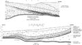
File:C605-Figure-36.jpg {{Galatia Channel Image ...July 1983, representing the northern half of the channel. The lower image is from Peabody’s Eby Pit in June 1982, representing the southern half of th(3,157 × 1,744 (956 KB)) - 15:37, 17 August 2023- the figure is on the Herrin Coal Member page, in the Fossils section, and is image number 21 (of that section). ...g : bitmap image compressed in the standard JPEG format (this lossy format is most suitable for photographs).1 KB (216 words) - 22:34, 28 January 2021
- {{#formlink:form=Image upload the figure is on the Herrin Coal Member page, in the Fossils section, and is image number 21 (of that section).2 KB (310 words) - 20:21, 21 December 2020
File:Penn carbondale 4-80.jpg {{Image ...Limestone can be seen at the top of the image. Approximate height of view is 5 ft (1.5 m). Photograph 1976 from ISGS files. © University of Illinois Bo(2,441 × 1,741 (1.54 MB)) - 21:38, 4 January 2021- ...oad file]]. Make note of the name as you will need it later to insert the image in the page. See file naming conventions below.<br> This field will be used as the caption for the image. <br>5 KB (786 words) - 21:59, 15 September 2022
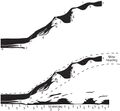
File:C605-Figure-27.jpg {{Galatia Channel Image ...oated away from the lower. The seam height at the left side of the diagram is approximately 9 ft (2.7 m).(1,418 × 1,307 (196 KB)) - 15:59, 17 August 2023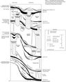
File:Penn carbondale plate4-1.jpg {{Image ...embers and beds of the Carbondale Formation. All are members unless “bed” is specified. © University of Illinois Board of Trustees.(3,855 × 4,791 (3.12 MB)) - 21:42, 4 January 2021
File:Penn carbondale 4-2.jpg {{Image After Kosanke et al. (1960). Current nomenclature is applied. © University of Illinois Board of Trustees.(2,308 × 2,840 (808 KB)) - 22:44, 28 January 2021- | image = B94.jpg '''Click the column headers to sort the table, by default it is sorted by "Stratigraphic Code"'''57 members (0 subcategories, 0 files) - 13:13, 12 July 2018
File:Penn carbondale 4-73.jpg {{Image ...hannel and Walshville Member in Franklin County, southern Illinois. Well 2 is the type log for the Walshville Member. © University of Illinois Board of(3,627 × 2,980 (3.05 MB)) - 21:16, 4 January 2021
File:Penn carbondale 4-22.jpg {{Image ...orehole PON-62 in sec. 2, T 27 N, R 6 E, Livingston County, Illinois. This is a reference section for the Francis Creek Shale Member. © University of Il(2,230 × 2,901 (1.31 MB)) - 16:17, 23 December 2020- {{{for template|Galatia Channel Image}}} {{{info|page name=File:<Galatia Channel Image[File name]>}}}2 KB (201 words) - 18:22, 29 June 2020
File:Penn carbondale 4-79.jpg {{Image ...illiamson County, Illinois. Photograph 1976 from ISGS files. The geologist is Christopher Ledvina. © University of Illinois Board of Trustees.(2,588 × 2,104 (2.27 MB)) - 21:36, 4 January 2021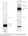
File:Penn carbondale 4-67.jpg {{Image ...ole WKUG-9 drilled in Carter section 17-P-19, Union County, Kentucky. This is the reference section for the Briar Hill Coal. © University of Illinois Bo(2,224 × 2,859 (692 KB)) - 21:37, 27 January 2021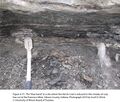
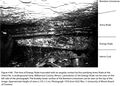
File:Penn carbondale 4-77.jpg {{Image |Caption=Figure 4-77. The “blue band” at a site where the Herrin Coal is reduced to thin streaks of coal, box cut at the Francisco Mine, Gibson Coun(2,401 × 2,041 (4.22 MB)) - 21:29, 4 January 2021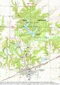
File:Penn carbondale 4-18.jpg {{Image ...Coal, showing locations of the measured sections in Figure 4-19. Base map is a Colchester 7.5-minute topographic sheet, used courtesy of the U.S. Geolog(2,352 × 3,327 (5.71 MB)) - 21:13, 26 January 2021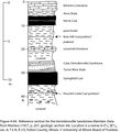
File:Penn carbondale 4-64.jpg {{Image Data from Wanless (1957, p. 207, geologic section 44). Location is a ravine in(1,711 × 1,870 (467 KB)) - 22:00, 23 December 2020
File:Penn carbondale 4-13.jpg {{Image ...incipal reference section for the Dekoven and Davis Coal Members. Location is in Carter section 5-M-18, Union County, Kentucky. © University of Illinois(1,059 × 3,660 (466 KB)) - 21:07, 26 January 2021
File:Penn carbondale 4-8.jpg {{Image ...boring no. 1, a reference section for the Seelyville Coal Member. Location is in sec. 20, T 13 N, R 9 W, Vigo County, Indiana. © University of Illinois(1,293 × 3,533 (556 KB)) - 21:02, 26 January 2021


