Search results
Jump to navigation
Jump to search
Page title matches
- ...}}} {{#set: Image=Yes}} {{#set: filename={{FULLPAGENAME}}}}{{#default_form:Image upload}}|}}210 bytes (21 words) - 23:08, 28 January 2021
- [http://maschek.hu/imagemap/imgmap/ Use the free online image map editor here] ==Image preparation==2 KB (269 words) - 19:56, 3 February 2017
- 350 bytes (57 words) - 17:09, 7 December 2016
- {{#formlink:form=Image upload the figure is on the Herrin Coal Member page, in the Fossils section, and is image number 21 (of that section).2 KB (310 words) - 20:21, 21 December 2020
- {{#if:{{{Map hires|}}}|Download Full Resolution Image: '''[{{{Map hires}}} HERE]'''}} {{#set:has image=yes}}1 KB (170 words) - 20:30, 17 July 2020
Page text matches
- [http://maschek.hu/imagemap/imgmap/ Use the free online image map editor here] ==Image preparation==2 KB (269 words) - 19:56, 3 February 2017

File:Imagemap 1.JPG image for image map howto(600 × 576 (62 KB)) - 13:42, 2 December 2016- [[Has image::Yes]] [[Image no::~*Plate*]]314 bytes (34 words) - 21:15, 29 June 2020
- ...}}} {{#set: Image=Yes}} {{#set: filename={{FULLPAGENAME}}}}{{#default_form:Image upload}}|}}210 bytes (21 words) - 23:08, 28 January 2021
File:C605-Figure-03.jpg {{Galatia Channel Image |caption=Satellite image of the mouth of the Mississippi River showing natural levees and crevasse s(1,384 × 926 (1.29 MB)) - 15:42, 17 August 2023- image = 'Ambox warning pn.svg' image = 'Ambox warning pn.svg'6 KB (448 words) - 16:51, 13 August 2015
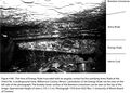
File:C605-Figure-36.jpg {{Galatia Channel Image ...ine in July 1983, representing the northern half of the channel. The lower image is from Peabody’s Eby Pit in June 1982, representing the southern half of(3,157 × 1,744 (956 KB)) - 15:37, 17 August 2023- the figure is on the Herrin Coal Member page, in the Fossils section, and is image number 21 (of that section). * .jpg or .jpeg : bitmap image compressed in the standard JPEG format (this lossy format is most suitable1 KB (216 words) - 22:34, 28 January 2021
File:Figure C-3 imagemap.jpg Cambrian Image Map(350 × 971 (100 KB)) - 15:08, 30 November 2016- {{#formlink:form=Image upload the figure is on the Herrin Coal Member page, in the Fossils section, and is image number 21 (of that section).2 KB (310 words) - 20:21, 21 December 2020

File:Imagemap 2.JPG image for imagemap howto(600 × 582 (103 KB)) - 13:44, 2 December 2016
File:Quaternary imagemap.jpg Image for Quaternary imagemap(600 × 717 (675 KB)) - 20:36, 19 January 2017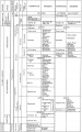
File:Figure O-4 imagemap.jpg Image map for the Ordovician System(600 × 959 (140 KB)) - 15:58, 22 December 2016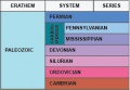
File:Paleozoic imagemap.jpg Image map for the Paleozoic page(316 × 219 (63 KB)) - 19:32, 29 December 2016
File:Figure M-3 imagemap.jpg Image map for the Mississippian subsystem(600 × 1,078 (162 KB)) - 14:27, 20 January 2017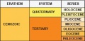
File:Cenozoic search.jpg image map of the Cenozoic search page(314 × 154 (45 KB)) - 17:27, 3 March 2017- | image = {{#if:{{{image|}}}|[[File:{{{image}}}|frameless|108px|alt={{{alt|}}}|link={{{store|}}}]]|}} | image = B95.jpg2 KB (189 words) - 15:05, 14 November 2016
File:Penn carbondale 4-80.jpg {{Image ...obby lower surface of the Brereton Limestone can be seen at the top of the image. Approximate height of view is 5 ft (1.5 m). Photograph 1976 from ISGS file(2,441 × 1,741 (1.54 MB)) - 21:38, 4 January 2021- ...oad file]]. Make note of the name as you will need it later to insert the image in the page. See file naming conventions below.<br> This field will be used as the caption for the image. <br>5 KB (786 words) - 21:59, 15 September 2022
File:Figure K-2 imagemap.jpg Image used for Cretaceous System imagepage<br> image: Figure_K-2_imagemap.jpg<br>(350 × 730 (71 KB)) - 19:49, 15 November 2016


