Search results
Jump to navigation
Jump to search
- [http://maschek.hu/imagemap/imgmap/ Use the free online image map editor here] ==Image preparation==2 KB (269 words) - 19:56, 3 February 2017
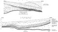
File:C605-Figure-36.jpg {{Galatia Channel Image ...July 1983, representing the northern half of the channel. The lower image is from Peabody’s Eby Pit in June 1982, representing the southern half of th(3,157 × 1,744 (956 KB)) - 15:37, 17 August 2023- the figure is on the Herrin Coal Member page, in the Fossils section, and is image number 21 (of that section). ...g : bitmap image compressed in the standard JPEG format (this lossy format is most suitable for photographs).1 KB (216 words) - 22:34, 28 January 2021
- {{#formlink:form=Image upload the figure is on the Herrin Coal Member page, in the Fossils section, and is image number 21 (of that section).2 KB (310 words) - 20:21, 21 December 2020
File:Penn carbondale 4-80.jpg {{Image ...Limestone can be seen at the top of the image. Approximate height of view is 5 ft (1.5 m). Photograph 1976 from ISGS files. © University of Illinois Bo(2,441 × 1,741 (1.54 MB)) - 21:38, 4 January 2021- ...oad file]]. Make note of the name as you will need it later to insert the image in the page. See file naming conventions below.<br> This field will be used as the caption for the image. <br>5 KB (786 words) - 21:59, 15 September 2022
File:C605-Figure-27.jpg {{Galatia Channel Image ...oated away from the lower. The seam height at the left side of the diagram is approximately 9 ft (2.7 m).(1,418 × 1,307 (196 KB)) - 15:59, 17 August 2023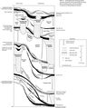
File:Penn carbondale plate4-1.jpg {{Image ...embers and beds of the Carbondale Formation. All are members unless “bed” is specified. © University of Illinois Board of Trustees.(3,855 × 4,791 (3.12 MB)) - 21:42, 4 January 2021
File:Penn carbondale 4-2.jpg {{Image After Kosanke et al. (1960). Current nomenclature is applied. © University of Illinois Board of Trustees.(2,308 × 2,840 (808 KB)) - 22:44, 28 January 2021- | image = B94.jpg '''Click the column headers to sort the table, by default it is sorted by "Stratigraphic Code"'''57 members (0 subcategories, 0 files) - 13:13, 12 July 2018
File:Penn carbondale 4-73.jpg {{Image ...hannel and Walshville Member in Franklin County, southern Illinois. Well 2 is the type log for the Walshville Member. © University of Illinois Board of(3,627 × 2,980 (3.05 MB)) - 21:16, 4 January 2021
File:Penn carbondale 4-22.jpg {{Image ...orehole PON-62 in sec. 2, T 27 N, R 6 E, Livingston County, Illinois. This is a reference section for the Francis Creek Shale Member. © University of Il(2,230 × 2,901 (1.31 MB)) - 16:17, 23 December 2020- {{{for template|Galatia Channel Image}}} {{{info|page name=File:<Galatia Channel Image[File name]>}}}2 KB (201 words) - 18:22, 29 June 2020
File:Penn carbondale 4-79.jpg {{Image ...illiamson County, Illinois. Photograph 1976 from ISGS files. The geologist is Christopher Ledvina. © University of Illinois Board of Trustees.(2,588 × 2,104 (2.27 MB)) - 21:36, 4 January 2021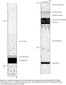
File:Penn carbondale 4-67.jpg {{Image ...ole WKUG-9 drilled in Carter section 17-P-19, Union County, Kentucky. This is the reference section for the Briar Hill Coal. © University of Illinois Bo(2,224 × 2,859 (692 KB)) - 21:37, 27 January 2021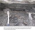
File:Penn carbondale 4-77.jpg {{Image |Caption=Figure 4-77. The “blue band” at a site where the Herrin Coal is reduced to thin streaks of coal, box cut at the Francisco Mine, Gibson Coun(2,401 × 2,041 (4.22 MB)) - 21:29, 4 January 2021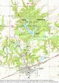
File:Penn carbondale 4-18.jpg {{Image ...Coal, showing locations of the measured sections in Figure 4-19. Base map is a Colchester 7.5-minute topographic sheet, used courtesy of the U.S. Geolog(2,352 × 3,327 (5.71 MB)) - 21:13, 26 January 2021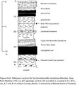
File:Penn carbondale 4-64.jpg {{Image Data from Wanless (1957, p. 207, geologic section 44). Location is a ravine in(1,711 × 1,870 (467 KB)) - 22:00, 23 December 2020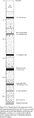
File:Penn carbondale 4-13.jpg {{Image ...incipal reference section for the Dekoven and Davis Coal Members. Location is in Carter section 5-M-18, Union County, Kentucky. © University of Illinois(1,059 × 3,660 (466 KB)) - 21:07, 26 January 2021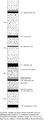
File:Penn carbondale 4-8.jpg {{Image ...boring no. 1, a reference section for the Seelyville Coal Member. Location is in sec. 20, T 13 N, R 9 W, Vigo County, Indiana. © University of Illinois(1,293 × 3,533 (556 KB)) - 21:02, 26 January 2021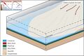
File:C605-Figure-49.jpg {{Galatia Channel Image the sea level began to fall. The product is a thick succession of clastic rocks that coarsen upward.(2,103 × 1,405 (428 KB)) - 16:08, 17 August 2023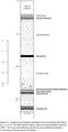
File:Penn carbondale 4-7.jpg {{Image ...W, Pike County, Indiana. Data from Hasenmueller and Ault (1991). This core is the reference section for the underlined members. © University of Illinois(1,558 × 3,020 (456 KB)) - 21:01, 26 January 2021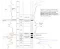
File:Penn carbondale 4-15.jpg {{Image ...amson County, the type section for the Will Scarlet Shale Member. Location is in sec. 6, T 10 S, R 4 E, Williamson County, Illinois. © University of Ill(2,979 × 2,447 (1.32 MB)) - 21:11, 26 January 2021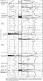
File:Penn carbondale 4-3.jpg {{Image Franklin County, Illinois. This is the reference log for the Carbondale Formation. Lithologic patterns in the(2,786 × 5,273 (3.5 MB)) - 22:44, 28 January 2021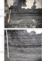
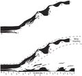
File:C605-Figure-11.jpg {{Galatia Channel Image ...County, Indiana. The lower frame is a closer view of the upper. The ruler is graduated in 0.1-ft intervals.(1,689 × 2,450 (1.34 MB)) - 15:51, 17 August 2023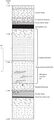
File:C605-Figure-32.jpg {{Galatia Channel Image ...quences, the lower having tidal rhythmites in the upper part. The borehole is ISGS No. 1 Elysium (Hazel Farm) in sec. 27, T4N, R9E (county no. 25922).(1,143 × 2,536 (411 KB)) - 16:01, 17 August 2023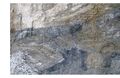
File:C605-Figure-46.jpg {{Galatia Channel Image ...oal stringer crossing diagonally from the lower to upper “bench.” The site is the box cut at a portal of the Prosperity Mine in Gibson County, Indiana.(2,285 × 1,477 (1.09 MB)) - 16:07, 17 August 2023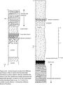
File:Penn carbondale 4-65.jpg {{Image ...n Coal. This sandstone actually represents the Walshville Member. Location is on the south bank of the Vermilion River in sec. 31, T 33 N, R 2 E, LaSalle(2,078 × 2,779 (766 KB)) - 22:02, 23 December 2020
File:Penn carbondale 4-62.jpg {{Image ...1942). Copyright © 1942 University of Illinois Board of Trustees. Base map is a Streator 15-minute topographic sheet, used courtesy of the U.S. Geologica(2,359 × 3,115 (7.43 MB)) - 21:56, 23 December 2020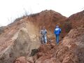
File:Fig 0870 Photos 002.JPG {{Image ...NRCS, Soil Scientist) on the right, for scale. Sangamon Geosol development is visible in the upper portion of the unit. This area contains fine sand beds(2,272 × 1,704 (1.15 MB)) - 22:06, 15 September 2022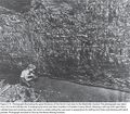
File:Penn carbondale 4-75.jpg {{Image ...ring a soft cap with open-flame carbide lamp and smoking a pipe, the miner is undercutting the coal seam in preparation for drilling shot holes and blast(2,844 × 2,497 (4.66 MB)) - 21:26, 4 January 2021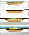
File:C605-Figure-37.jpg {{Galatia Channel Image ...tial development of the Leslie Cemetery channel. (a) The Francisco channel is eroded and filled with sediment, largely sand. (b) Springfield peat accumul(1,535 × 1,872 (579 KB)) - 19:29, 23 August 2023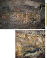
File:C605-Figure-20.jpg {{Galatia Channel Image ...d Coal “split” by massive siltstone in the Millennium Mine. The lower view is a close-up of the upper view. Notice the ragged splaying of coal layers int(1,800 × 2,200 (1.15 MB)) - 15:56, 17 August 2023
File:Fig 0870 Photos 001.JPG {{Image ...is interpreted to be from ice-block melting. The depositional environment is here interpreted to be an ice-walled channel. Photograph by David Grimley,(2,592 × 1,944 (2.35 MB)) - 22:04, 15 September 2022
File:C605-Figure-13.jpg {{Galatia Channel Image ...se-up view on the west wall of the entry. The heart of the Galatia channel is south (left) of view. Notice how erosion undercut the clay below layers of(1,395 × 2,297 (822 KB)) - 15:53, 17 August 2023- image: Figure_K-2_imagemap.jpg '''Click the column headers to sort the table, by default it is sorted by "Stratigraphic Code"'''20 members (0 subcategories, 0 files) - 16:22, 31 August 2022
- image: Figure_K-2_imagemap.jpg Stratigraphic column is from ISGS Bulletin 95 (1975).<br>1 KB (124 words) - 17:17, 31 August 2022
File:Penn carbondale 4-20.jpg {{Image ...f coal are at the lower right. Separating the lower and upper coal benches is gray, weakly laminated siltstone that resembles normal Francis Creek Shale.(2,391 × 1,614 (778 KB)) - 21:44, 22 December 2020- |<imagemap>Image:Tertiary_imagemap.jpg|450px Stratigraphic column is from ISGS Bulletin 95 (1975).<br>1 KB (157 words) - 15:01, 30 March 2020
- ...g2-credit">[https://ilstratwiki.web.illinois.edu/wiki/File:Figure_M-1B.jpg Image Source]</div> In most cases, the geologic information on each page is based on historical unit descriptions from either ISGS Bulletin 94, 95, or4 KB (531 words) - 22:04, 31 August 2023
- -- This is a meta-module for producing message box templates, including -- boxType is "mbox" or invalid input16 KB (2,313 words) - 16:51, 13 August 2015
- ...es the module can display a template notifying users that the current page is a ...the location of test cases pages, etc. The module decides whether the page is a18 KB (2,047 words) - 16:51, 13 August 2015
- background-image: url("https://ilstratwiki.web.illinois.edu/images/b/b5/Banner.jpg"); /* When <div class="noautonum"> is used on the table of contents,9 KB (1,066 words) - 21:24, 10 August 2021
- image: Figure_C-3_imagemap.jpg '''Click the column headers to sort the table, by default it is sorted by "Stratigraphic Code"'''66 members (0 subcategories, 0 files) - 14:27, 11 January 2017
- if args.image then args.image1 = args.image13 KB (1,438 words) - 16:51, 13 August 2015
- image: Figure_C-3_imagemap.jpg Stratigraphic column is from ISGS Bulletin 95 (1975).<br>2 KB (185 words) - 15:20, 30 March 2020
- -- * alt - the alt text for the small padlock icon. This is also used as tooltip -- * image - the padlock image used in both protection banners and small padlock43 KB (5,245 words) - 16:51, 13 August 2015
- ...this graphic can be found by clicking on their corresponding names on the image, or in the alphabetical listing of names below the geologic column. Both li ...ara' oil producing zone is found within the Karnak Limestone Member, which is within the Ste. Genevieve Limestone (Formation).<br>76 members (0 subcategories, 0 files) - 15:20, 29 May 2020
- This is the "B94" form. | {{{field|geo_image|uploadable|property=Has image|values from namespace=File}}}3 KB (404 words) - 17:08, 7 November 2016
- This is the "B94" form. | {{{field|geo_image|uploadable|property=Has image|values from namespace=File}}}3 KB (404 words) - 16:23, 7 November 2016


