Ridenhower Formation
Lithostratigraphy: Pope Megagroup >>West Baden Group >>Paint Creek Group >>Ridenhower Formation
Chronostratigraphy: Paleozoic Erathem >>Mississippian Subsystem >>Chesterian Series >>Gasperian Stage
Allostratigraphy: Kaskaskia Sequence
Primary source
Willman, H. B., Elwood Atherton, T. C. Buschbach, Charles Collinson, John C. Frye, M. E. Hopkins, Jerry A. Lineback, and Jack A. Simon, 1975, Handbook of Illinois Stratigraphy: Illinois State Geological Survey Bulletin 95, 261 p.
Contributing author(s)
Elwood Atherton, Charles Collinson, and Jerry A. Lineback
Name
Original description
Ridenhower Formation (Butts, 1917, p. 73).
Derivation
Named for Ridenhower School, Johnson County.
Other names
History/background
Type section
Type location
The type section of the Ridenhower Formation is at Indian Point, 5 miles south of Vienna (SE SW 32, 13S-3E), where the formation is 60 feet thick and consists of shale with beds of fossiliferous limestone.
Type author(s)
Type status
Reference section
Reference location
Reference author(s)
Reference status
Stratigraphic relationships
The contact of the Ridenhower with the overlying Cypress Sandstone is generally sharp. In some places the Ridenhower is absent and the Cypress rests on the Bethel Sandstone.
Extent and thickness
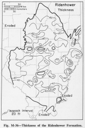
The average thickness of the Ridenhower Formation in southern Illinois is about 33 feet, but at several places it is more than 80 feet thick (fig. M-36).
Lithology
The formation is a markedly varied unit that is mainly shale but contains beds of limestone and sandstone. It occurs between two clastic formations, dominantly sandstone. Locally, in parts of central and eastern Illinois, the formation is subdivided into the Beaver Bend Limestone Member, the Sample Sandstone Member, and the Reelsville Limestone Member, but in most of Illinois these units cannot be differentiated. They are well developed in Indiana and Kentucky, where they were named. The shale of the Ridenhower is mainly dark greenish gray, but red, green, and brown shales are common. Much of the shale is calcareous and fossiliferous. The limestone includes sandy, oolitic, crinoidal, and lithographic beds, most of which are light to dark gray and brown, but buff, green, pink, and yellow beds are present. Some distinctive beds can be traced for several tens of miles. The proportion of limestone in the formation increases westward, so that near its western limit the formation is almost all limestone. In contrast, the proportion of sandstone is greatest in southeastern Illinois from Hardin County north-northeast along the Wabash River.
Core(s)
Photograph(s)
Contacts
Well log characteristics
Fossils
The fauna of the Ridenhower resembles that of the Renault. The bryozoans Cystodictya and Archimedes and the blastoid Pentremites are common.
Age and correlation
Environments of deposition
Economic importance
“Sample” and “upper Paint Creek” are informal names applied to producing zones in the Ridenhower Formation.
Remarks
References
BUTTS, CHARLES, 1917, Descriptions and correlations of the Mississippian formations of western Kentucky, Part I of Mississippian formations of western Kentucky: Kentucky Geological Survey, v. 1, 119 p.
ISGS Codes
| Stratigraphic Code | Geo Unit Designation |
|---|---|
