Saverton Shale
Lithostratigraphy: Knobs Megagroup >>New Albany Shale Group >>Saverton Shale
Chronostratigraphy: Paleozoic Erathem >>Devonian System >>Upper Devonian Series
Allostratigraphy: Kaskaskia Sequence
Primary source
Willman, H. B., Elwood Atherton, T. C. Buschbach, Charles Collinson, John C. Frye, M. E. Hopkins, Jerry A. Lineback, and Jack A. Simon, 1975, Handbook of Illinois Stratigraphy: Illinois State Geological Survey Bulletin 95, 261 p.
Contributing author(s)
Charles Collinson and Elwood Atherton
Name
Original description
The Saverton Shale (Keyes, 1912, p. 149).
Derivation
Named for Saverton, Ralls County, Missouri.
Other names
History/background
Type section
Type location
No type section was designated for the Saverton Shale by Keyes, but Mehl (1960) named an exposure in the Mississippi River bluff at Louisiana, Pike County, Missouri, as the type section, the same exposure named as the type for the Grassy Creek Shale (a section in the Mississippi bluffs several hundred feet north of the Champ Clark Bridge at Louisiana, Pike County, Missouri, (SW NW NE 18, 54N-1W)).
Type author(s)
Type status
Reference section
Reference location
Reference author(s)
Reference status
Stratigraphic relationships
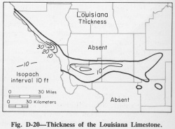
The Saverton Shale is a gray shale overlying the black Grassy Creek Shale and underlying the Louisiana Limestone. Because the Louisiana Limestone is limited to a small area in Illinois (fig. D-20), the Saverton is more commonly overlain by the Mississippian "Glen Park" or Hannibal Formations.
Extent and thickness
The Saverton is well exposed in western Illinois in and near the Mississippi and Illinois River bluffs in Pike, Calhoun, and Jersey Counties. It is 5-110 feet thick in western Illinois, but is generally less than 10 feet thick where overlain by the Louisiana Limestone. In eastern and southern Illinois, it is commonly not differentiated and is included in the Hannibal Formation.
Lithology
The Saverton is a bluish to greenish gray, silty shale that contains both thin sandy beds and calcareous beds and grades to calcareous siltstone in the upper part. It grades into the overlying Louisiana Limestone, the lower part of which in places grades laterally into the uppermost Saverton.
Core(s)
Photograph(s)
Contacts
Well log characteristics
Fossils
The few macrofossils present in the Saverton include Spirifer marionensis and Orbinaria puxidata. Conodonts are abundant, especially in the siltstone at the top, and Palmatolepis minuta, P. gracilis, P. glabra, and P. quadratinodosa marginifera indicate an Upper Devonian age (Scott and Collinson, 1961; Collinson et al., 1967a).
Age and correlation
Environments of deposition
Economic importance
Remarks
References
COLLINSON, CHARLES, L. E. BECKER, G. W. JAMES, J. W. KOENIG, and D. H. SWANN, 1967a, Illinois Basin, in International symposium on the Devonian System: Alberta Society of Petroleum Geologists, v. 1, p. 940-962; Illinois State Geological Survey Reprint 1968-G.
KEYES, C. R., 1912, Some provincial and local phases of the general geologic section of Iowa: Iowa Academy of Science Proceedings, v. 19, p. 147-151.
MEHL, M. G., 1960, Relationships of the base of the Mississippian System in Missouri: Denison University Journal of Scientific Laboratories, v. 45, p. 57-107.
SCOTT, A. J., and CHARLES COLLINSON, 1961, Conodont faunas from the Louisiana and McCraney Formations of Illinois, Iowa, and Missouri, in Kansas Geological Society Guidebook, 26th Field Conference, northeastern Missouri and west central Illinois: Missouri Geological Survey Report of Investigations 27, p. 110-141; Illinois State Geological Survey Reprint 1961-V.
ISGS Codes
| Stratigraphic Code | Geo Unit Designation |
|---|---|
