Historical:Waltersburg Formation
Lithostratigraphy: Pope Megagroup >>Waltersburg Formation
Chronostratigraphy: Paleozoic Erathem >>Mississippian Subsystem >>Chesterian Series >>Elviran Stage
Allostratigraphy: Kaskaskia Sequence
Authors
Elwood Atherton, Charles Collinson, and Jerry A. Lineback
Name Origin
The Waltersburg Formation (S. Weller, 1920, p. 398) is named for Waltersburg, Pope County.
Type Section
The type section of the Waltersburg Formation is located near the town of Waltersburg, Pope County (SE cor. 17, 13S-6E).
Extent and Thickness
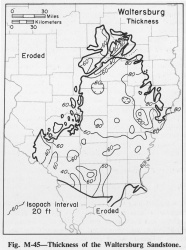
The Waltersburg is 50-75 feet thick throughout most of Illinois (fig. M-45), but it thins to about 30 feet to the west in Randolph County and thickens to 80-100 feet to the northeast in Jasper and Richland Counties. The thickness increases at the edge of the Walche Member at the base of the Menard, where the top of the Waltersburg steps up from the base of the Walche to the base of the Scottsburg Limestone Member.
Description
The Waltersburg is a clastic unit consisting mainly of shale, but it has beds of siltstone and sandstone. The Waltersburg Formation is mainly dark gray, slightly carbonaceous shale, in part silty and sandy. Green shale occurs in the upper part of the Waltersburg, and a thin coal is present near the top of the formation close to its southern edge. In the south, some of the shale at the top and bottom of the formation is calcareous and fossiliferous, and until recently it was assigned to the Menard above or the Vienna below (Swann, 1963). The Waltersburg includes beds and laminae of dark gray and dark olive siltstone and beds of gray to white sandstone that is very fine to fine grained, locally quartzitic, and characteristically well jointed. Most of the thick sandstone bodies in the Waltersburg are within 30 miles of the Wabash River (Swann, 1951; Potter, 1963), are strongly linear, and trend northeast-southwest. They are well exposed on Bay Creek between Simpson and Grantsburg, near the Pope-Johnson county line.
References
POTTER, P. E., 1963, Late Paleozoic sandstones of the Illinois Basin: Illinois State Geological Survey Report of Investigations 217, 92 p.
SWANN, D. H., 1951, Waltersburg Sandstone oil pools of lower Wabash area, Illinois and Indiana: American Association of Petroleum Geologists Bulletin, v. 35, p. 2561-2581; Illinois State Geological Survey Report of Investigations 160.
SWANN, D. H., 1963, Classification of Genevievian and Chesterian (Late Mississippian) rocks of Illinois: Illinois State Geological Survey Report of Investigations 216, 91 p.
WELLER, STUART, 1920, Chester Series in Illinois: Journal of Geology, v. 28, p. 281-303, 395-416.
ISGS Codes
| Stratigraphic Code | Geo Unit Designation |
|---|---|

