Historical:Salem Limestone
Lithostratigraphy: Mammoth Cave Limestone Megagroup >>Salem Limestone
Chronostratigraphy: Paleozoic Erathem >>Mississippian Subsystem >>Valmeyeran Series
Allostratigraphy: Kaskaskia Sequence
Authors
Elwood Atherton, Charles Collinson, and Jerry A. Lineback
Name Origin
The Salem Limestone (Cumings, 1901, p. 233) is named for Salem, Washington County, Indiana, where it is extensively quarried for Indiana building stone. It was called "Spergen Hill" or "Spergen" limestone in early reports.
Type Section
No type section was designated, but a quarry 0.8 mile east of Salem is considered the principal reference section (Shaver et al., 1970).
Extent and Thickness
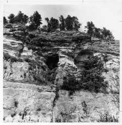
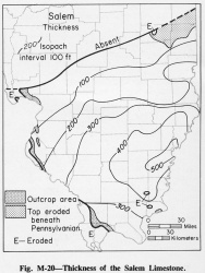
The Salem Limestone forms prominent outcrops in Illinois in parts of Hardin County, along the Mississippi River in Randolph (fig. M-1D), Monroe, and Madison Counties, and in places in western Illinois. It is over 500 feet thick in southeastern Illinois and thins northward (fig. M-20). Small patches occur northwest of the area mapped.
Stratigraphic Position
The Salem generally overlies the Ullin, but where the Ullin pinches out northward the Salem rests on the Warsaw Shale or the Sonora Formation. The Salem is overlain by the St. Louis Limestone.
Description
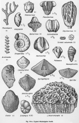
The Salem is a biocalcarenite consisting of rounded, broken, fossil fragments and whole small fossils, commonly with banded, oolitic-like overgrowths, that are imbedded in a matrix that ranges from micrite to sparite. Endothyrid foraminifers are commonly abundant (fig. M-4). Minor lithologies in the Salem include biocalcilutite, biocalcirudite, sucrosic dolomite, dolomitic limestone, fine-grained limestone, fossiliferous crystalline limestone, sandstone, chert, and the evaporites anhydrite and gypsum. Some fine-grained, silty, dolomitic beds weather yellow and form reentrants on the weathered faces. The Salem differs from the underlying Ullin by having a greater variety of fossils and fossils with banded overgrowths. In the outcrop area in Monroe County and extending from Prairie du Rocher, Randolph County, to Dupo, St. Clair County, the Salem is divided into the Kidd (at the base), Fults, Chalfin, and Rocher Members, largely on the basis of differences in textures (Baxter, 1960a). The Kidd and Fults Members are lithologically and faunally similar to the type Salem in Indiana. The upper part of the Salem grades laterally into the St. Louis Limestone in Madison County and northward (Lineback, 1972). The lower part can be identified into Christian County and northward, but the biocalcarenite grades laterally into dolomitic limestone and fossiliferous limestone that contain evaporites and sandstone in places. The lateral gradation is the result of the southward deepening of the water from shallow water near the shore in north-central Illinois to deeper water near the center of the Illinois Basin.
References
BAXTER, J. W., 1960a, Salem Limestone in southwestern Illinois: Illinois State Geological Survey Circular 284, 32p.
CUMINGS, E. R., 1901, Use of Bedford as a formational name: Journal of Geology, v. 9, p. 232-233.
LINEBACK, J. A., 1972, Lateral gradation of the Salem and St. Louis Limestones (Middle Mississippian) in Illinois: Illinois State Geological Survey Circular 474, 23 p.
SHAVER, R. H., et al., 1970, Compendium of rock-unit stratigraphy in Indiana: Indiana Geological Survey Bulletin 43, 229 p.
ISGS Codes
| Stratigraphic Code | Geo Unit Designation |
|---|---|


