Historical:Porters Creek Formation
Lithostratigraphy: Embayment Megagroup >>Porters Creek Formation
Chronostratigraphy: Cenozoic Erathem >>Tertiary System >>Paleocene Series
Authors
H. B. Willman and John C. Frye
Name Origin
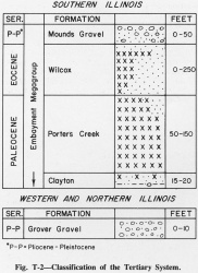
The Porters Creek Formation (Safford, 1864, p. 361, 368) (fig. T-2) is named for exposures on Porters Creek in Hardeman County, Tennessee.
Extent and Thickness
It is present in Alexander and Pulaski Counties in southern Illinois (Lamar, 1928b; Pryor and Ross, 1962) and is well exposed in pits south of Olmsted, Pulaski County (NE SE 27, 15S-1E), in the Ohio River bluffs near U.S. Dam 53, and along the Cache River near Unity. It is 50-150 feet thick, but north of the Cache Valley it is completely truncated by the Mounds Gravel.
Stratigraphic Position
The Porters Creek is overlain unconformably by the Wilcox Formation, which locally cuts deeply into the Porters Creek.
Description
The Porters Creek is largely massive, compact, essentially unbedded or weakly bedded, dark gray to nearly black clay that has a blocky fracture. It is gray-tan to white where weathered. Because it does not readily become plastic when wet, it can stand in steeper faces than most clays. It is more than 80 percent montmorillonite. Because the clay has the absorptive and filtering properties of fuller's earth, it has been mined commercially south of Olmsted, Pulaski County.
Fossils
Microfossils (Radiolaria, Hystrichospheridae, and Foraminifera) are abundant, but fish scales, shark teeth, and casts and molds of pelecypods and gastropods are also common.
Depositional Environment
The Porters Creek is a marine deposit representing an advance of the sea over essentially the entire area of the embayment.
References
LAMAR, J. E., 1928b, Preliminary report on the fuller's earth deposits of Pulaski County: Illinois State Geological Survey Report of Investigations 15, 31 p.
PRYOR, W. A., and C. A. ROSS, 1962, Geology of the Illinois parts of the Cairo, La Center, and Thebes Quadrangles: Illinois State Geological Survey Circular 332, 39 p.
SAFFORD, J. M., 1864, On the Cretaceous and superior formations of west Tennessee: American Journal of Science, v. 37, p. 360-372.
ISGS Codes
| Stratigraphic Code | Geo Unit Designation |
|---|---|

