Historical:Plano Silt Member
Lithostratigraphy: Winnebago Formation >>Plano Silt Member
Chronostratigraphy: Cenozoic Erathem >>Quaternary System >>Pleistocene Series
Authors
H. B. Willman and John C. Frye
Name origin
The Plano Silt Member of the Winnebago Formation was named the Plano Silt (Kempton and Hackett, 1968b, p. 31) for Plano, Kendall County.
Type section
The type section is the Big Rock Creek Section (Kempton and Hackett, 1968b, p. 32), an exposure in the east bank of Big Rock Creek 3.5 miles northeast of Plano, SE NE Sec. 1, T. 37 N., R. 6 E.
Stratigraphic relationships
The Plano Member is bounded above by its contact with the Capron Till Member and at the base by its contact with the Argyle Till Member. The member is also described in Greenway School cores 2 and 4 (Frye et al., 1969).
Extent and thickness
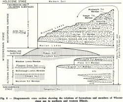
Spatial relations of the Plano Silt Member are shown diagrammatically in figure 8.
Lithology
The Plano Silt consists of silt, organic silt, and peat.
Age and correlation
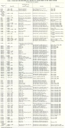
Radiocarbon dates determined from the Plano are listed in table 1. The Plano is in the later part of the Altonian Substage of the Wisconsinan Stage.
Environments of deposition
It is the product of slow accumulation of silt, loess, and organic matter during the interval of glacial withdrawal between the deposition of the Argyle and Capron Till Members.
References
FRYE, J. C., H. D. GLASS, J. P. KEMPTON, and H. B. WILLMAN, 1969, Glacial Tills of Northwestern Illinois: Illinois State Geological Survey Circular 437, 47 p.
KEMPTON, J. P., and J. E. HACKETT, 1968b, Stratigraphy of the Woodfordian and Altonian drifts of central northern Illinois, in R.E. Bergstrom, editor, The Quaternary of Illinois—A Symposium in Observance of the Centennial of the University of Illinois College of Agriculture [Urbana] Special Publication 14, p. 27-34.
ISGS Codes
| Stratigraphic Code | Geo Unit Designation |
|---|---|


