Historical:Parkland Sand
Lithostratigraphy: Parkland Sand
Chronostratigraphy: Cenozoic Erathem >>Quaternary System >>Holocene Series
Authors
H. B. Willman and John C. Frye
Name origin
The Parkland Sand is classified as a formation and is named for Parkland, Tazewell County, a small village 3 miles northeast of Manito.
Type section
The type locality is a roadcut in the edge of the Manito Terrace 5 miles west of Parkland, SW SE SW Sec. 2, T. 23 N., R. 7 W.
Extent and thickness
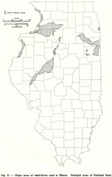
The Parkland Sand is widespread throughout the northern part of Illinois (fig. 11), and small areas are present in the southern part, most of them along the Wabash River Valley. The dunes are largely on terraces along the major valleys and consist of medium-grained sand sorted by the wind from underlying glacial outwash, which is mostly sand and pebbly sand. In many areas the dunes have migrated onto the bluffs and uplands east of the terraces, in some places as much as 2 or 3 miles inland.
The Parkland Sand also occurs along shorelines of glacial lakes where it has been blown from sand of the Equality Formation. Dunes also occur locally on the beaches of Lake Chicago.
Lithology
The Parkland Sand consists of windblown sand in dunes and in sheet-like deposits between and bordering the dunes. The type locality roadcut exposes 10 to 20 feet of uniform, well sorted, medium-grained sand typical of the Parkland Formation that overlies 25 feet of pebbly sand and sandy gravel of the Henry Formation. The Parkland Sand is well exposed in shallow roadcuts and scattered "blowouts" among the dunes throughout the Manito Terrace. Grain-size and mineral analyses of the sand have been reported (Willman, 1942; Wanless, 1957). Most of the sand is fine grained in the dunes farthest from the source area in the terraces. Dunes 20 to 40 feet high are common; a few are 80 to 100 feet.
Age and correlation
Most of the dunes are anchored by vegetation, and some have a thin cover of loess. It appears that many were formed soon after the terraces were free from glacial flooding, and they vary in age from Woodfordian through Holocene.
References
WANLESS, H. R., 1957, Geology and mineral resources of the Beardstown, Glasford, Havana, and Vermont Quadrangles: Illinois State Geological Survey Bulletin 82, 233 p.
WILLMAN, H. B., 1942, Feldspar in Illinois sands— A study of resources: Illinois State Geological Survey Report of Investigations 79, 87 p.
ISGS Codes
| Stratigraphic Code | Geo Unit Designation |
|---|---|

