Historical:Misenheimer Shale Member
Lithostratigraphy: Hunton Limestone Megagroup >>Lingle Formation >>Misenheimer Shale Member
Chronostratigraphy: Paleozoic Erathem >>Devonian System >>Middle Devonian Series
Allostratigraphy: Kaskaskia Sequence
Authors
Charles Collinson and Elwood Atherton
Name Origin
The Misenheimer Shale Member of the Lingle Formation (Savage, 1920, p. 169-178; Grimmer, 1968, p. 407-415) overlies the Tripp Member and is named for Misenheimer Creek in Union County.
Type Section
Grimmer (1968) described the type section of the Misenheimer Member as an exposure 3 miles west of Mill Creek (SW NW 35, 13S-2W) in the south branch of a tributary of Cooper Creek. He designated an exposure on the south bank of Green Creek, 33 feet southwest of Illinois Highway 146, 1.75 miles northwest of Jonesboro (NE NW 23, 12S-2W), where the shale is about 25 feet thick, as a principal reference section.
Extent and Thickness
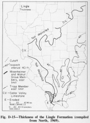
The Misenheimer occurs only in and near the outcrop region in Jackson, Union, and Alexander Counties (fig. D-15).
Stratigraphic Position
Both Grimmer (1968) and North (1969) placed the type Misenheimer well above the base of the Lingle (where Savage had placed it), but Grimmer assigned the strata below the Misenheimer to the St. Laurent Formation of Missouri, whereas North subdivided them into the Howardton and Tripp Members of the Lingle.
Description
The Misenheimer Member consists of as much as 50 feet of dark gray to gray-brown, calcareous, spore-bearing shale that contains a few macrofossils.
References
GRIMMER, J. C., 1968, Stratigraphy of the Middle Devonian shales of southern Illinois: Illinois Academy of Science Transactions, v. 61, p. 407-415.
NORTH, W. G., 1969, Middle Devonian strata of southern Illinois: Illinois State Geological Survey Circular 441, 45 p.
SAVAGE, T. E., 1920, Devonian formations of Illinois: American Journal of Science, v. 49, p. 169-182.
ISGS Codes
| Stratigraphic Code | Geo Unit Designation |
|---|---|

