Historical:Clayton Formation
Lithostratigraphy: Embayment Megagroup >>Clayton Formation
Chronostratigraphy: Cenozoic Erathem >>Tertiary System >>Paleocene Series
Authors
H. B. Willman and John C. Frye
Name Origin
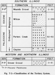
The Clayton Formation (Landon, 1891, p. 594) (fig. T-2), is named for exposures near Clayton, Barbour County, Alabama.
Extent and Thickness
The Clayton Formation is persistently present at the base of the Paleocene Series in southern Illinois (Pryor and Ross, 1962). It is well exposed in a small ravine northwest of U.S. Dam 53 in Pulaski County (SE NW NE 13, 15S-1E). It is commonly 15-20 feet thick.
Description
The Clayton consists of glauconitic, micaceous, green to buff silty clay that is sandy and pebbly at the base. The Clayton is generally less sandy and more glauconitic than the Owl Creek Formation below, and the contact, which is unconformable, is marked by pebbles of white and black chert and iron oxide in the base of the Clayton.
Fossils
Foraminifera are the main fossils in the Clayton Formation, but the remains of radiolarians and other plankton also are present.
References
LANDON, D. W., 1891, Variations in the Cretaceous and Tertiary strata of Alabama: Geological Society of America Bulletin, v. 2, p. 587-605.
PRYOR, W. A., and C. A. ROSS, 1962, Geology of the Illinois parts of the Cairo, La Center, and Thebes Quadrangles: Illinois State Geological Survey Circular 332, 39 p.
ISGS Codes
| Stratigraphic Code | Geo Unit Designation |
|---|---|

