Historical:Carmi Member
Lithostratigraphy: Carmi Member
Chronostratigraphy: Cenozoic Erathem >>Quaternary System >>Pleistocene Series
Authors
H. B. Willman and John C. Frye
Name origin
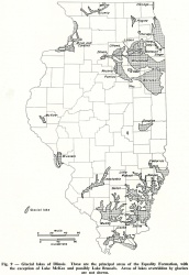
The Carmi Member of the Equality Formation is named for Carmi, White County, which is located on a terrace underlain by lacustrine sediments that were deposited in Lake Little Wabash (fig. 9). The deposits are locally exposed along the Little Wabash River at Winters Bridge 4 miles north of Carmi.
Type section
The type section is along Crooked Creek 5 miles northeast of Carmi, NE corner SW Sec. 21, T. 4 S., R. 10 E. The type section exposes 4 feet of red, medium-grained sand of the Parkland Sand on 2 feet of tan-brown, leached silt of the Peoria Loess, overlying 6 feet of the Carmi Member. The Equality type section is also typical of the Carmi Member.
Extent and thickness
The Carmi Member is generally less than 20 feet thick, and in many of the lake basins the sediments are less than 5 feet thick. Locally they are more than 50 feet thick (Butts, 1925).
Lithology
The Carmi consists of sandy, slightly pebbly, leached clay that is gray in the upper part but mottled brown and black in the lower part. Sample P-7113 is from the top, P-7112 from the middle, and P-7111 from the base. Typical exposures of the Carmi Member in Lake Chicago and in smaller lakes on the Valparaiso Drift were described by Bretz (1955). The Carmi Member generally consists of well bedded layers of silt and clay with some fine-grained sand. In areas that have thick loess on the surrounding hills, the lacustrine sediments are dominantly massive silt that resembles the loess. The lacustrine silts generally have more clay than the loess.
Environment of deposition
In a few lake basins the deposits form an essentially continuous sheet, but in others they were widely eroded soon after deposition so that only remnants remain, and loess rests directly on till over large parts of the lake plains.
References
BRETZ, J. H., 1955, Geology of the Chicago region, Part II — The Pleistocene: Illinois State Geological Survey Bulletin 65, 132 p.
BUTTS, Charles, 1925, Geology and mineral resources of the Equality-Shawneetown area (parts of Gallatin and Saline Counties): Illinois State Geological Survey Bulletin 47, 76 p. (in coop, with United States Geological Survey).
ISGS Codes
| Stratigraphic Code | Geo Unit Designation |
|---|---|

