Historical:Cahokia Alluvium
Lithostratigraphy: Cahokia Alluvium
Chronostratigraphy: Cenozoic Erathem >>Quaternary System >>Holocene Series
Authors
H. B. Willman and John C. Frye
Name origin
The Cahokia Alluvium is named for Cahokia, St. Clair County, which is located on the floodplain of the Mississippi River in the broad area east of St. Louis that is called the American Bottoms.
Cahokia Alluvium replaces the long-used term "Recent Alluvium" because (a) the alluvium is a distinctive lithologic unit and should be included in the rock-stratigraphic classification and not named for a time unit; (b) the term Recent is replaced in this report by Holocene, making the change appropriate at this time; and (c) in many valleys only the upper part of the alluvium is of Recent, or Holocene, age.
Type section
The type section is in a well (Illinois Geological Survey test hole 2, Bergstrom and Walker, 1956, p. 31-32) 3 miles southwest of Cahokia, 0.8 mile south of the center of East Carondelet. The upper 45 feet is Cahokia Alluvium consisting largely of silt, clay, and clayey sand, with wood and shell fragments, overlying 60 feet of sand and gravel of theHenry Formation, which rests on bedrock.
Reference section
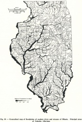
Eight feet of well bedded brown silt at the top of the Cahokia Alluvium is exposed near a bridge crossing Prairie du Pont Creek 3 miles southeast of Cahokia and half a mile east of Stolle, St. Clair County. The Cahokia Alluvium is here classified as a formation. It consists of deposits in the floodplains and channels of modern rivers and streams (fig. 10).
Stratigraphic relationships
In most of Illinois the Cahokia Alluvium is distinguished from older deposits by not having a cover of loess. In some valleys in the unglaciated areas, alluvium of mixed
local material occurs on narrow benches above the present floodplain, and these commonly have a cover of loess.
The Cahokia Alluvium generally rests unconformably on bedrock and glacial deposits. In the major valleys, the alluvium generally rests on glacial valley-train deposits of the Mackinaw Member of the Henry Formation. In places where deposition was continuous, the outwash deposits generally are well sorted but the alluvium is poorly sorted. Most valleys, however, were deepened after the outwash was deposited, and the alluvium rests with sharp contact on the glacial or older deposits. Many of the valleys that have floodplains were eroded after glaciation, but probably only the smaller tributaries contain floodplain deposits entirely of Holocene age.
Although the Cahokia Alluvium commonly is in the process of formation, it locally is overlain by Grayslake Peat or Peyton Colluvium, and at a very few places it may be overlain by the Lacon Formation or the Parkland Sand.
Extent and thickness
The Cahokia Alluvium is present along all Illinois streams (fig. 10), although locally absent in localities where the stream is actively eroding. The thickness varies greatly, but 10 to 20 feet is common along many valleys and 50 to 75 feet is found along major valleys. The present Mississippi River is believed to erode as much as 50 feet deep during flood stages.
Lithology
The alluvium is dominantly a silty deposit because much of it is derived from erosion of loess and till. Loess was still accumulating in the region when some of the alluvium was deposited. Although lenses of sand and gravel are locally common in the alluvium, these lenses generally have a relatively high silt content. The degree of sorting varies but is generally poor. The major part of the alluvium consists of materials transported down the valley and deposited in the floodplains during intervals of flooding, but it also includes sediments deposited directly by tributary streams. The latter sediments commonly consist of lenses of relatively coarse material intertongued with floodplain silts. In some areas the contributions from the tributary valleys are large, and they accumulate in broad alluvial fans that the major river occasionally floods but does not greatly erode. Alluvial fans 1 to 2 miles wide are prominent features at the mouths of tributary streams in the Illinois Valley. In some places they partly dam the valley, forming lake-like expansions of the river, like Peoria Lake above the alluvial fan at the mouth of Farm Creek at East Peoria. Although common along the Illinois Valley, which has a very low gradient, the fans are smaller and less abundant along the Mississippi Valley, which has a higher gradient. As the fans intertongue with and are not readily differentiated from the floodplain deposits and are continuous with the alluvium in the valley from which they are derived, they are considered part of the Cahokia Alluvium.
Age and correlation
As the alluvium began to accumulate in many valleys as soon as they were free of ice, the deposits vary in age; some are as old as early Woodfordian. The general character of the alluvium in the American Bottoms has been described by Bergstrom and Walker (1956, p. 17, 28, 30) and in various parts of the state by Butts (1925), Lamar (1925a), Wanless (1929a, 1957), Willman and Payne (1942), Rubey (1952), and others.
The Cahokia Alluvium is Wisconsinan and Holocene in age.
References
BERGSTROM, R. E., and T. R. WALKER, 1956, Ground-water geology of the East St. Louis area, Illinois: Illinois State Geological Survey Report of Investigations 191, 44 p.
BUTTS, Charles, 1925, Geology and mineral resources of the Equality-Shawneetown area (parts of Gallatin and Saline Counties): Illinois State Geological Survey Bulletin 47, 76 p. (in coop, with United States Geological Survey).
LAMAR, J. E., 1925a, Geology and mineral resources of the Carbondale Quadrangle: Illinois State Geological Survey Bulletin 48, 172 p.
RUBEY, W. W., 1952, Geology and mineral resources of the Hardin and Brussels Quadrangles: United States Geological Survey Professional Paper 218, 179 p.
WANLESS, H. R., 1929a, Geology and mineral resources of the Alexis Quadrangle: Illinois State Geological Survey Bulletin 57, 230 p.
WANLESS, H. R., 1957, Geology and mineral resources of the Beardstown, Glasford, Havana, and Vermont Quadrangles: Illinois State Geological Survey Bulletin 82, 233 p.
WILLMAN, H. B., and J. N. PAYNE, 1942, Geology and mineral resources of the Marseilles, Ottawa, and Streator Quadrangles: Illinois State Geological Survey Bulletin 66, 388 p.
ISGS Codes
| Stratigraphic Code | Geo Unit Designation |
|---|---|

