Guttenberg Formation
Lithostratigraphy: Ottawa Limestone Megagroup >>Galena Group >>Decorah Subgroup >>Guttenberg Formation
Chronostratigraphy: Paleozoic Erathem >>Ordovician System >>Champlainian Series >>Trentonian Stage
Allostratigraphy: Tippecanoe Sequence
Primary source
Willman, H. B., Elwood Atherton, T. C. Buschbach, Charles Collinson, John C. Frye, M. E. Hopkins, Jerry A. Lineback, and Jack A. Simon, 1975, Handbook of Illinois Stratigraphy: Illinois State Geological Survey Bulletin 95, 261 p.
Contributing author(s)
H. B. Willman and T. C. Buschbach
Name
Original description
The Guttenberg Formation (Kay, 1928, p. 16; 1935b, p. 289).
Derivation
The Guttenberg Formation is named for Guttenberg, Clayton County, Iowa.
Other names
History/background
Type section
Type location
The type section of the Guttenberg Formation is located in a ravine 0.5 mile north of Guttenberg, Clayton County, Iowa. It is better exposed in a roadcut on U.S. Highway 52 on the northwest side of Guttenberg, where the formation is 16.5 feet thick (Templeton and Willman, 1963, p. 236).
Type author(s)
Type status
Reference section
Reference location
Reference author(s)
Reference status
Stratigraphic relationships
The Guttenberg Formation at the top of the Decorah Subgroup in Illinois, overlies the Spechts Ferry Formation in northwestern Illinois and the Kings Lake Formation in the southwestern part of the state.
Extent and thickness
The Guttenberg Formation is widely present in Illinois, and it is exposed in the localities described in the Decorah discussion. It is about 15 feet thick in the northwestern Illinois outcrop area and is 10-15 feet thick in southwestern Illinois. It thins eastward and is 3-5 feet thick in the outcrop area in central northern Illinois. In subsurface elsewhere it is only 1-3 feet thick and locally is missing. On the flanks of the Ozarks the Guttenberg Formation is thinned and cut out in some localities by overlap of the Dunleith Formation.
Lithology
In the western part of Illinois, the Guttenberg consists of thin-bedded, tan, white-weathering, very fine-grained limestone interbedded with brown-red shale. Eastward it grades to brown, white-weathering, medium-grained, vuggy dolomite containing thin beds of brown-red shale. The dolomite facies is well exposed in the central northern outcrop area. The lower part, which is grayer, more argillaceous, and less shaly than the upper part, is differentiated as the Garnavillo Member, and the upper part is the Glenhaven Member. A thin but widely present bentonite occurs in a shale at the base of the Glenhaven. In the northwestern Illinois mining district the Guttenberg is locally thinned by solution of the limestone beds, largely in and close to the ore bodies, leaving a residue of brown-red shale called the "oilrock," which is only 2-4 feet thick.
Core(s)
Photograph(s)
Contacts
Well log characteristics
Fossils
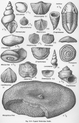
The reddish color of the Guttenberg is in part due to the abundance of minute resinous particles, probably the spores of algae. The Guttenberg has an abundant and varied fauna of brachiopods, bryozoans, mollusks, and, in places, a few trilobites. Sowerbyella (fig. O-5) is most abundant in the Guttenberg, which includes the Rhinidictya and Ctenodonta beds of early reports.
Age and correlation
The Guttenberg Formation is equivalent to the Napanee Member of the Rockland Formation in New York, the upper part of the Logana Formation in Kentucky, and the middle part of the Hermitage Formation in Tennessee.
Environments of deposition
Economic importance
Remarks
References
KAY, MARSHALL, 1928, Divisions of the Decorah Formation: Science, v. 67, p. 16.
KAY, MARSHALL, 1935b, Ordovician System in the Upper Mississippi Valley: Kansas Geological Society Guidebook, 9th Annual Field Conference, p. 281-295.
TEMPLETON, J. S., and H. B. WILLMAN, 1963, Champlainian Series (Middle Ordovician) in Illinois: Illinois State Geological Survey Bulletin 89, 260 p.
ISGS Codes
| Stratigraphic Code | Geo Unit Designation |
|---|---|
