Briar Hill Coal Member
Lithostratigraphy: Carbondale Formation >>Briar Hill Coal Member
Chronostratigraphy: Paleozoic Erathem >>Pennsylvanian Subsystem >>Desmoinesian Series
Allostratigraphy: Absaroka Sequence
Primary source
Nelson, W.J., P.H. Heckel and J.M. Obrad, 2022, Pennsylvanian Subsystem in Illinois: Illinois State Geological Survey, Bulletin (in press).
Contributing author(s)
W.J. Nelson
Name
Original description
Discussing Owen’s (1857) Coal No. 10, Glenn (1912, p. 38) remarked, “It is known at Dekoven [Union County, Kentucky] as the Briar Hill coal.” Lee (1916, p. 32–33) later expanded on Glenn’s description. First to use the name in Illinois was Butts (1925, p. 47, 65–66), who also designated the seam as No. 5½ because it resides between the No. 5 (Springfield) and No. 6 (Herrin) coals. Cady (1952) amended the number to 5A.
Derivation
Lee (1916, p. 33) wrote that the name was derived from “the first mine on this bed being situated near a conspicuous briar patch on the hill north of Sturgis road in the environs of Dekoven.”
Other names
A.M. Burger and C.E. Wier (in Shaver et al. 1970, p. 27–28) named the Bucktown (Vb) Coal Member for a village in Sullivan County, Indiana, and located (but did not describe) the type section. The Indiana Geological Survey has consistently used Bucktown since. Because the Briar Hill and Bucktown are the same bed, the name Bucktown should be abandoned.
History/background
See above.
Type section
None. Mines that formerly worked this seam near Dekoven, Kentucky, were sealed long ago.
Reference section(1)
Reference location
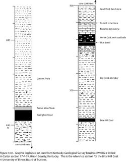
Core from Kentucky Geological Survey borehole WKUG-9 is hereby offered as a principal reference section for the Briar Hill Coal. The hole was drilled in Carter section 17-P-19 in Union County, which is approximately 15 mi (24 km) north of Dekoven and close to the common corner of Illinois, Indiana, and Kentucky. As logged in WKUG-9, the Briar Hill is 1.69 ft (51.5 cm) thick and lies in the depth interval of 566.6 to 568.3 ft (172.7 to 172.3 m; Figure 4-67). The coal is composed of alternating layers of clairain and durain, with a few pyrite lenses and laminae and two laminae of claystone near the top. Overlying the coal is gray shale, and underlying it is sandstone that has root traces.
Reference author(s)
This report.
Reference status
Logs of WKUG-9 are on file with the Kentucky Geological Survey, and core is archived at the Kentucky Geological Survey core facility in Lexington.
Reference section(2)
Reference location
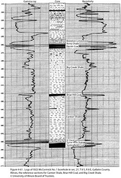
The ISGS #1 McCormick core serves as a second reference section for the Briar Hill Coal. This hole was drilled in Section 21, T8S, R8E, Gallatin County, Illinois (ISGS county no. 25246). The Briar Hill is 1.5 ft (45 cm) thick in the McCormick core and occurs in the depth interval of 323.5 to 325.0 ft (98.6 to 99.1 m; Figure 4-61).
Reference author(s)
Present report.
Reference status
Logs from this hole, including typed core descriptions and gamma-ray and resistivity logs, are on file with the ISGS Geological Samples Library and can be accessed via the ISGS website. Core is archived at the ISGS Geological Samples Library in Champaign under storage number C-15339.
Stratigraphic relationships
The Briar Hill directly overlies the Canton Shale or Vermilionville Sandstone Member and underlies the Big Creek Shale Member, as revised in this report.
Extent and thickness
No maps of the Briar Hill are known. A survey of unpublished cross sections, core data, and other information indicates that the coal is largely confined to the Fairfield Basin in Illinois, along with parts of southwestern and west-central Indiana and at least the western part of the Western Kentucky coalfield. The western limit is near the Du Quoin Monocline and its northward extension; the northern limit runs fairly close to Interstate 70 from Terre Haute, Indiana, southwest toward Vandalia, Illinois. The range of the Briar Hill closely matches that of the southeastern field of thick Springfield Coal. Within this area, the Briar Hill seems to be consistently present, except where eroded by paleochannels. The coal thickness ranges from a few inches (~10 cm) to more than 4 ft (1.2 m) but exceeds 2 ft (60 cm) only in limited areas. The thickest known Briar Hill is in the “Bucktown” type area of Sullivan County, Indiana. Core drilling and exposures in the currently active Bear Run Mine, a multiseam surface operation and linked into regional cross sections by P.R. Ames (formerly of Peabody Energy Company), verify beyond a reasonable doubt that the Bucktown and Briar Hill are the same unit.
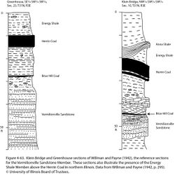
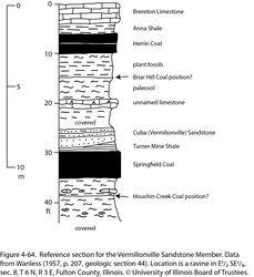
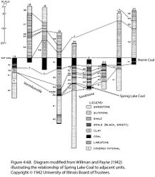
Isolated outcrops of the Briar Hill occur outside the Fairfield Basin. Willman and Payne (1942) described several outcrops north of Streator in LaSalle County that show this unit, including mines near Spring Lake, where the coal attained a thickness of 2.5 ft (76 cm; Figures 4-63 and 4-68). The Briar Hill in LaSalle County is topped by carbonaceous shale and rests on well-developed underclay. A section by Wanless (1957) from Fulton County shows what is likely the Briar Hill underclay (Figure 4-64).
Some authors reported two thin coal seams in the interval between Springfield and Herrin. These reports mostly involve misidentification among the Springfield, Briar Hill, Herrin, and Hymera Coals. For example, Shaver et al. (1970) mistook the Herrin Coal near Danville, Illinois, for the Bucktown (Briar Hill). Southeastward from Danville, the Herrin gradually thins, and the interval between the Danville and Herrin markedly thickens as a wedge of Energy Shale is interposed. Thin Springfield Coal persistently tracks 15 to 25 ft (5 to 8 m) below the Herrin from Danville southward into central Vigo County, Indiana, where the Briar Hill appears in the succession.
|
Lithology
The Briar Hill is bright-banded coal that becomes shaly and dull as it thins. Pyrite and shale or claystone laminae are common but not laterally persistent. Overlying the coal is medium to dark gray shale or siltstone (Big Creek Member) or less commonly, sandstone. Although marine fossils locally occur directly above the coal, no limestone or black, fissile shale overlies the Briar Hill. Mudstone, siltstone, or sandstone below the coal bears root traces, but the underclay is absent or weakly developed in the deeper part of the basin. At some sites in northern and western Illinois, a paleosol is developed at what is believed to be the Briar Hill position (Figure 4-64).
Core(s)
Photograph(s)
Contacts
Contacts of the Briar Hill Coal with the underlying Canton Member and overlying Big Creek Member normally are abrupt.
Well log characteristics
Typical for coal.
Fossils
Kosanke (1950, p. 74) discussed fossil spores of the Briar Hill Coal and remarked that they allow this seam to be “readily differentiated from either the No. 5 or No. 6 coal beds.” Peppers (1970) provided further data on spores of the Briar Hill and concurred with Kosanke (1950) that they distinguish this seam from the Springfield and Herrin.
Age and correlation
The Briar Hill may be correlative with the Alvis Coal Bed, which lies between the Summit Coal (Springfield equivalent) and Lexington Coal (Herrin equivalent) in western Missouri and northeastern Kansas.
Environments of deposition
The Briar Hill apparently reflects an intermediate regression that mainly affected the southeastern part of the Illinois Basin. Following a brief episode of soil formation, a thin to moderately thick blanket of peat accumulated, to be buried during an ensuing transgression.
Economic importance
The Briar Hill has been mined at scattered localities in west-central Indiana, southern Illinois, and western Kentucky. Most extraction took place in multiseam stripping operations that focused on the older Springfield and younger Herrin, Hymera, and Danville Coals and taking the Briar Hill as a “bonus.” Only in Sullivan County, Indiana, was the Briar Hill thick enough to be a primary target for mining.
Remarks
References
- Butts, C., 1925, Geology and mineral resources of the Equality-Shawneetown area: Illinois State Geological Survey, Bulletin 47, 76 p., 2 pls.
- Cady, G.H., 1952, Minable coal reserves of Illinois: Illinois State Geological Survey, Bulletin 78, 138 p., 8 pls.
- Glenn, L.C., 1912, A geological reconnaissance of the Tradewater River region, with special reference to the coal beds: Kentucky Geological Survey, Bulletin 17, 75 p.
- Kosanke, R.M., 1950, Pennsylvanian spores of Illinois and their use in correlation: Illinois State Geological Survey, Bulletin 74, 128 p., 2 pls.
- Lee, W., 1916, Geology of the Kentucky part of the Shawneetown Quadrangle: Kentucky Geological Survey, Series 4, Bulletin 4, Part 2, 73 p.
- Owen, D.D., 1856, Report on the geological survey in Kentucky made during the years 1854 and 1855: Kentucky Geological Survey, Series 1, v. 1, p. 3–148.
- Peppers, R.A., 1970, Correlation and palynology of coals in the Carbondale and Spoon Formations (Pennsylvanian) of the northeastern part of the Illinois Basin: Illinois State Geological Survey, Bulletin 93, 173 p.
- Shaver, R.H., Ann M. Burger, G.R. Gates, H.H. Gray, H.C. Hutchison, S.J. Keller, J.B. Patton, C.B. Rexroad, N.M. Smith, W.J. Wayne, and C.E. Wier, 1970, Compendium of rock-unit stratigraphy in Indiana: Indiana Geological Survey, Bulletin 43, 229 p., 1 pl.
- Wanless, H.R., 1957, Geology and mineral resources of the Beardstown, Glasford, Havana, and Vermont Quadrangles: Illinois State Geological Survey, Bulletin 82, 233 p.
- Willman, H.B., and J.N. Payne, 1942, Geology and mineral resources of the Marseilles, Ottawa, and Streator Quadrangles: Illinois State Geological Survey, Bulletin 66, 388 p., 29 pls.
ISGS Codes
| Stratigraphic Code | Geo Unit Designation |
|---|---|
