Carbondale Formation
Lithostratigraphy: Carbondale Formation
Chronostratigraphy: Paleozoic Erathem >>Pennsylvanian Subsystem >>Desmoinesian Series
Allostratigraphy: Absaroka Sequence
Primary source
Nelson, W.J., P.H. Heckel and J.M. Obrad, 2022, Pennsylvanian Subsystem in Illinois: Illinois State Geological Survey, Bulletin (in press).
Contributing author(s)
W.J. Nelson
Name
Original description
With the following preamble, Shaw and Savage (1912, p. 6–7) introduced the Carbondale Formation:
- Through the work of David White on the fossil plants it is known that the Pottsville, Allegheny, and Conemaugh formations of Pennsylvania and other eastern states are represented in southern Illinois, though their exact correlation and limits have not yet been determined. The upper limit of the Pottsville, which is known with fair accuracy, lies a very short distance below the Murphysboro (No. 2) coal, and for convenience the base of the underclay of that coal will be used as the formation boundary. The division plane between the strata of Allegheny and overlying Conemaugh age is much more difficult to determine; it probably lies near the Herrin (No. 6) or the No. 7 coal, but its exact place is doubtful. For this reason local formation names will be applied and the top of the Herrin coal will be used as the formation boundary.
Shaw and Savage thus interposed the Carbondale Formation between the Pottsville Formation below and the newly named McLeansboro Formation (now Group) above.
Derivation
According to Callary (2009, p. 58), the City of Carbondale (Jackson County) was “founded in 1852 with construction of the Illinois Central Railroad. The name was suggested by Daniel H. Brush, one of the founders of Carbondale. In his words, ‘I proposed that inasmuch as the town was in a coal region it should be called Carbondale, which was agreed to, and this name was entered upon the plat.’” Daniel Brush was not directly involved in coal mining, but his nephew, Samuel T. Brush, organized the St. Louis & Big Muddy Coal Company, which operated underground mines northeast of Carbondale during the late 19th and early 20th century.
Other names
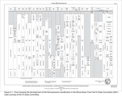
DeWolf (1910, p. 180–181) used the terms La Salle1 (older) and Petersburg formations for the strata that came to be called Carbondale Formation. Petersburg survives as a division of the Carbondale in Indiana. Lee (1916) extended the Carbondale into Kentucky; Cumings (1922) did the same for Indiana. As shown by Figure 4-1, numerous authors adjusted the unit boundaries. Some authors ranked the Carbondale as a group, a ranking still used by the Indiana Geological Survey. Despite such minor alterations, the essential character of the Carbondale has changed little since 1912.
History/background
Lines (1912, p. 59, 74) had mentioned the “Carbondale formation” briefly in a report that appeared a few months earlier than the folio of Shaw and Savage. Definitions differ in that Lines placed the formation base at the bottom of the Murphysboro Coal, rather than at the base of the underclay. Because Shaw and Savage (1912) covered the Carbondale comprehensively, whereas Lines (1912) treated the unit only in passing, Shaw and Savage are considered the authors of record.
Type section
No type section has been designated. The section that Kosanke et al. (1960) called the type section actually is a reference section (see below). Bedrock in the Carbondale area is largely covered by glacial drift and no suitable outcrops exist.
Reference section (1)
Reference location
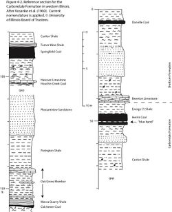
A composite of three outcrop sections in Fulton County, western Illinois, was proposed as the “type section of the Carbondale Formation.” This is actually a reference section because it is remote from the area where the formation was named. In addition, this section is incomplete because it does not extend to the Davis Coal, currently considered the basal member of the Carbondale (Figure 4-2). Nonetheless, this is a good reference for the Carbondale in western Illinois, showing most of the named members.
Reference author(s)
Kosanke et al. (1960, p. 65–67).
Reference status
The present condition of these outcrops is unknown. The upper and lower portions, in stream banks and road cuts, likely survive in good condition. The middle part, along a mine haulage road, is probably no longer extant.
Reference section (2)
Reference location
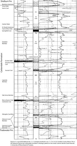
The DTE Methane Resources #11-1 Lexington borehole is hereby selected as the reference section for the Carbondale Formation in southern Illinois. This coal-bed methane exploration borehole was drilled in sec. 11, T 6 S, R 2 E, Franklin County (ISGS county no. 24941). Although this hole was not cored continuously, selected intervals of the Carbondale were cored, including the upper and lower contacts, and induction electric, sonic, gamma ray, density, and neutron logs are on file. The Carbondale Formation is 287.7 ft (87.7 m) thick in the #11-1 Lexington borehole and occupies the depth interval from 635.9 to 923.6 ft (193.8 to 281.5 m; Figure 4-3). Most of the named members of the Carbondale Formation are readily identified on logs of this hole.
Reference author(s)
This report.
Reference status
Logs of the #11-1 Lexington borehole are on file at the Geological Records Unit of the Illinois State Geological Survey (ISGS) and can be downloaded from the ISGS website. Core is archived at the ISGS Geological Samples Library in Champaign; it presently lacks a call number.
Stratigraphic relationships
Like most Pennsylvanian formations in this basin, the Carbondale is very much an artificial construction. Its definition is based on an arbitrary choice of boundary members. Multiple changes of the boundary beds have been introduced (Figure 4-1). The Carbondale is poorly fitted to be a formation under current stratigraphic codes, which envision formations as defined based on the overall lithologic content. But fundamentally, Pennsylvanian rocks of this basin resist being divided into formation-sized units. Unlike the Mississippian (for example), the Pennsylvanian lacks large, mappable bodies of rock that have a distinctive and consistent lithologic character.
Kosanke et al. (1960, p. 17–25) wrestled with the classification problem at length. They considered eight alternatives, ranging from designating individual coal and limestone beds as formations to making the entire Pennsylvanian a single formation. Their choice of “medium-sized bundles” as formations has proved to be practical because the Carbondale and its neighbors can be mapped at scales ranging from 7.5-minute quadrangles (at 1:24,000) to the entire state (at 1:500,000).
Differing choices of rank and boundary beds reflect differing needs and philosophies of various authors. They also reflect regional changes in the importance and continuity of key beds and members. The current boundaries, the base of the Davis/Seelyville Coal and the base of the Brereton/Providence Limestone, represent compromises on the part of the members of the Illinois, Indiana, and Kentucky Tri-State Committee (2001). In certain areas of the basin, either or both of the chosen boundary members are not mappable. At the base, the Davis/Seelyville Coal is persistent in most of Indiana, western Kentucky, and southern and central Illinois, but this member is thin, discontinuous, and difficult to identify in much of western and northern Illinois. Likewise, at the top, the Brereton/Providence Limestone is missing or lenticular in several areas of the basin. The Herrin and Danville Coals, previously used as upper contacts, have merits in large areas but elsewhere are missing or difficult to map. In extending the Carbondale Formation across the basin, local stepping of the upper and lower contacts appears inevitable.
In a general sense, the Carbondale encompasses the thickest, most extensive commercial coal deposits of the Illinois Basin, making its choice of name appropriate. Plate 4-1 illustrates the beds and members currently recognized in the Carbondale Formation.
Extent and thickness
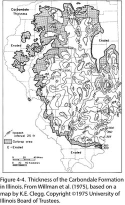
Except as limited by post-Pennsylvanian erosion, the Carbondale Formation occurs throughout the Illinois Basin. Originally, its strata probably were contiguous with those of the Appalachian and Midcontinent Basins. An isopach map (Figure 4-4) from Willman et al. (1975) shows that the thickness of the Carbondale varies from less than 150 ft (45 m) in parts of northern and western Illinois to more than 400 ft (122 m) in the southern part of the state. The influence of the Du Quoin Monocline, separating the Western (Sparta) Shelf from the southern Fairfield Basin, is evident on this map. Thinning of the formation also can be detected across the La Salle Anticlinorium, Loudon Anticline, and other structures. In western Kentucky, the Carbondale thickens from less than 250 ft (76 m) on the southeast to a little more than 400 ft (122 m) on the northwest (Greb et al. 1992, map, p. 39). In Indiana, the Carbondale ranges from 260 to 470 ft (79 to 143 m) thick, reaching its maximum in Posey County at the southwestern corner of the state (Shaver et al. 1986). Allowing for different boundaries of the Carbondale among the three states, the formation is thickest near the common corner. Evidently, tectonic subsidence was the main factor controlling the thickness of the formation.
Lithology
The bulk of the Carbondale, like the rest of the Pennsylvanian, is composed of gray shale or mudstone, siltstone, and sandstone. Rock bodies vary greatly in thickness and commonly grade laterally into one another. On the basis of gross lithology and proportions of clastic rock types, the Carbondale cannot be distinguished from the upper Tradewater or the formations of the McLeansboro Group.
Setting the Carbondale apart from the Tradewater is the greater lateral continuity of the coal, black shale, and limestone members. This difference is transitional: several upper Tradewater members, notably the Veale and Carrier Mills black shales, extend nearly basin-wide. However, none of the Tradewater coal units approach the Davis and younger Carbondale coal seams in continuity, especially at economic thickness. Tradewater coals thick enough to mine, such as the Rock Island and Murphysboro, are localized in abandoned channels or estuaries. Carbondale limestone units are far more extensive than are any of the Tradewater. In addition, as Udden (1912) remarked, the Carbondale displays fully developed sedimentary cycles. Cyclicity is present in older rocks but is commonly masked by local tectonic effects.
Core(s)
Photograph(s)
Contacts
As set forth by the Tri-State Committee (2001), the lower contact is the base of the Davis Coal Member in southern Illinois and western Kentucky and the correlative base of the Seelyville Coal Member in Indiana. This surface ordinarily is a sharp break between coal and underclay and is evident in thousands of outcrops, mine records, well cores, and geophysical well logs. The Davis/Seelyville Coal has been extensively mapped, mined, and targeted for coal exploration in Kentucky, Indiana, and southeastern and east-central Illinois. On the Western Shelf, however, this seam becomes thin, discontinuous, and difficult to identify. Thus, the base of the Carbondale on the Western Shelf needs to step up to the base of the Colchester Coal, which was formerly the lower contact throughout Illinois. The Colchester and overlying black Mecca Quarry Shale are virtually continuous and readily recognized throughout the Western Shelf.
Departing from historical precedent, the Tri-State Committee settled on the base of the Brereton or Providence Limestone as the upper contact of the Carbondale Formation. This was essentially a compromise between Kentucky, where the top of the Herrin Coal Member was always the Carbondale top, and Illinois and Indiana, which used the top of the younger Danville Coal. The Herrin Coal is absent or difficult to identify in most of Indiana, whereas the Danville Coal has not been mapped in Kentucky. Although locally sporadic, the Brereton/Providence is regionally present in all three states. In some of my own quadrangle mapping (e.g., Nelson 2007), I have found the base of the Brereton an unsatisfactory contact and have reverted to mapping the top of the Herrin Coal. This was done because the quantity and quality of data available on the coal far exceeds that available on the limestone. In many cases, coal data include elevation (structure) contours surveyed in underground mines, closely spaced coal-test exploration borings, or both.
That said, no formal redefinition of the Carbondale is proposed here. The Carbondale is considered herein to include the Energy and Anna Shale Members overlying the Herrin Coal, whereas the Brereton and Providence Limestones are included with the overlying Shelburn Formation.
Well log characteristics
Identifying and mapping the Carbondale Formation hinges on identifying its component members, the well-log features of which are outlined below.
Fossils
See component members.
Age and correlation
As Shaw and Savage (1912) intended, the Carbondale Formation is largely correlative with the Allegheny Formation in the northern Appalachian Basin. However, the Allegheny includes strata both older and younger than the Carbondale. In the Midcontinent, the upper part of the Cherokee Group and lower part of the Marmaton Group correspond to the Carbondale. For further details, see the individual members.
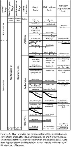
The Carbondale contains the middle part of the Desmoinesian Stage (Figure 4-5). Globally, this is middle and upper Moscovian. Peppers (1996) placed the Moscovian–Kasimovian boundary at the top of the Danville Coal (above the Carbondale) on the basis of fossil spores. Using ammonoid zonation, Boardman and Work (2013, chart, p. 106) suggested that this stage boundary is close to the Anna Shale Member at the top of the Carbondale. Applying Western European floral zonation, the Carbondale probably contains much of the Westphalian D Stage. The upper part of the Carbondale might be placed in the Cantabrian Stage; however, the validity of the Cantabrian and its correlation into North America remain controversial (Falcon-Lang et al. 2011; Wagner 2011).
Also shown on Figure 4-5 are correlations of named members in the Carbondale and adjoining formations into the Midcontinent and Appalachian Basins. Most coal, black shale, and limestone units correlate to the Midcontinent on a bed-for-bed basis; in fact, several units have the same name in both basins. Correlations to the northern Appalachian Basin are a bit less straightforward but appear fairly secure on the basis of palynology (Peppers 1996) combined with limited fusulinid, conodont, and ammonoid data (Heckel 2013).
Environments of deposition
See component members.
Economic importance
"Anvil Rock", "Cuba", "upper Dudley", "Dykstra", "Jake Creek", "Jamestown", "Pleasantview", and "1st or upper Siggins" are informal names applied to producing zones in the Carbondale Formation.
Coal seams in the Carbondale Formation account for the large majority of present and past coal production and remaining resources in the Illinois Basin. In fact, the occurrence of thick, regionally widespread, economically important coal deposits partly defines the Carbondale. Arguably, the Hymera, Baker, and Danville Coal Members, presently assigned to the Shelburn Formation (except in Indiana), belong in the Carbondale Formation.
Aside from coal, claystone and shale from the Carbondale formerly was mined in numerous localities to make brick, tile, and other clay products. A small amount of oil and gas production has been achieved from sandstone reservoirs in the Carbondale, chiefly in western Illinois. Sandstone and limestone from the formation have been quarried on a small scale for local use.
Remarks
1 The county and city derive their names from René-Robert Cavelier, Sieur de La Salle (1643–1687), the French explorer who traveled through the Great Lakes and the Illinois and Mississippi Rivers and claimed the entire Mississippi watershed for France. Most of this vast region remained under French control until acquired by the United States via the Louisiana Purchase (1803). The explorer’s surname is two words in French (La Salle). City and county names were La Salle in older maps and documents, but currently are rendered as one word, LaSalle.
References
- Boardman, D.R. and D.M. Work, 2013, Pennsylvanian (Desmoinesian-Virgilian) ammonoid zonation for Midcontinent North America: Stratigraphy, v. 10, no. 1–2, p. 105–116.
- Callary, E., 2009, Place names of Illinois: Urbana, University of Illinois Press, 425 p.
- Cumings, E.R., 1922, Nomenclature and description of the geological formations of Indiana, in W.N. Logan, E.R. Cumings, C.A. Malott, S.S. Visher, W.M. Tucker, and J.R. Reeves, Handbook of Indiana geology: Indiana Department of Conservation Publication 21, Part 4, p. 403–570.
- DeWolf, F. W., 1908, Coal investigations in Saline and Williamson Counties, Illinois: Illinois State Geological Survey, Bulletin 8, p. 230–245.
- Falcon-Lang, H.J., P.H. Heckel, W.A. DiMichele, B.M. Blake Jr., C.R. Easterday, C.F. Eble, S. Elrick, R.A. Gastaldo, S.F. Greb, R.L. Martino, W.J. Nelson, H.W. Pfefferkorn, T.L. Phillips, and S.J. Rosscoe, 2011, No major stratigraphic gap exists near the Middle-Upper Pennsylvanian (Desmoinesian-Missourian) boundary in North America: Palaios, v. 26, p. 125–139.
- Greb, S.F., D.A. Williams, and A.D. Williamson, 1992, Geology and stratigraphy of the western Kentucky coal field: Kentucky Geological Survey, Series 11, Bulletin 2, 77 p., 1 pl.
- Heckel, P.H., 2013, Pennsylvanian stratigraphy of Northern Midcontinent Shelf and biostratigraphic correlation of cyclothems: Stratigraphy, v. 10, nos. 1–2, p. 3–39.
- Kosanke, R.M., J.A. Simon, H.R. Wanless, and H.B. Willman, 1960, Classification of the Pennsylvanian strata of Illinois: Illinois State Geological Survey, Report of Investigations 214, 84 p. and 1 pl.
- Lee, W., 1916, Geology of the Kentucky part of the Shawneetown Quadrangle: Kentucky Geological Survey, Series 4, Bulletin 4, Part 2, 73 p.
- Lines, E.F., 1912, Stratigraphy of Illinois with reference to Portland-cement materials: Illinois State Geological Survey, Bulletin 17, p. 59–76.
- Nelson, W.J., 2007, Bedrock geology of Herrin Quadrangle, Williamson and Franklin Counties, Illinois: Illinois State Geological Survey, Illinois Geologic Quadrangle Map IGQ Herrin-BG, 2 sheets, 1:24,000.
- Peppers, R.A., 1996, Palynological correlation of major Pennsylvanian (Middle and Upper Carboniferous) chronostratigraphic boundaries in the Illinois and other coal basins: Geological Society of America, Memoir 188, 111 p. and correlation chart.
- Shaver, R.H., C. H. Ault, A.M. Burger, D.D. Carr, J.B. Droste, D.L. Eggert, H.H. Gray, D. Harper, N.R. Hasenmueller, W.A. Hasenmueller, A.S. Horowitz, H.C. Hutchison, B. Keith, S.J. Keller, J.B. Patton, C.B. Rexroad, and C.E. Wier, 1986, Compendium of Paleozoic rock-unit stratigraphy in Indiana—A revision: Indiana Geological Survey, Bulletin 59, 203 p.
- Shaw, E.W., and T.E. Savage, 1912, Murphysboro-Herrin folio: U.S. Geological Survey, Geologic Atlas of the United States, Folio No. 185, 13 p. and 6 maps, 1:62,500.
- Tri-State Committee on Correlation of the Pennsylvanian System in the Illinois Basin, 2001, Toward a more uniform stratigraphic nomenclature for rock units (formations and groups) of the Pennsylvanian System in the Illinois Basin: Illinois Basin Consortium Study 5, Joint publication of the Illinois State Geological Survey, Indiana Geological and Water Survey, and Kentucky Geological Survey, 26 p., 1 pl.
- Udden, J.A., 1912, Geology and mineral resources of the Peoria Quadrangle, Illinois: U.S. Geological Survey, Bulletin 506, 102 p. and 2 maps, 1:62,500.
- Wagner, R.H., 2011, Discussion of Falcon-Lang et al. (2011): Palaios, v. 26, p. 669–670.
- Willman, H.B., E. Atherton, T.C. Buschbach, C. Collinson, J.C. Frye, M.E. Hopkins, J.A. Lineback, and J.A. Simon, 1975, Handbook of Illinois stratigraphy: Illinois State Geological Survey, Bulletin 95, 261 p.
ISGS Codes
| Stratigraphic Code | Geo Unit Designation |
|---|---|
