Velpen Limestone Member: Difference between revisions
m (→Type section) |
mNo edit summary |
||
| Line 1: | Line 1: | ||
__NOTOC__ | __NOTOC__ | ||
{{DISPLAYTITLE:Velpen Limestone Member (abandoned)}} | {{DISPLAYTITLE:Velpen Limestone Member (abandoned)}} | ||
{{#css: | |||
#ca-key1 { display:none!important; } | |||
}} | |||
{{Tree | {{Tree | ||
|category1=Abandoned Names | |category1=Abandoned Names | ||
Revision as of 21:00, 9 February 2021
Lithostratigraphy: Carbondale Formation >>Velpen Limestone Member
Chronostratigraphy: Paleozoic Erathem >>Pennsylvanian Subsystem >>Desmoinesian Series
Allostratigraphy: Absaroka Sequence
Primary source
Nelson, W.J., 2020, Pennsylvanian Subsystem in Illinois: Illinois State Geological Survey Bulletin (in press).
Edited and figures drafted by Jennifer M. Obrad.
Contributing author(s)
W.J. Nelson
Name
Original description
In an unpublished manuscript, Wier (1961, p. 62–63) proposed the name “Velpen Limestone Member” for the thin limestone unit that directly overlies black, fissile shale (Mecca Quarry Member) above the Colchester Coal. The first published reference is in Shaver et al. (1970, p. 182–183).
Derivation
The limestone took its name from the unincorporated village of Velpen in Pike County, Indiana. The origin of the town’s name is unknown.
Other names
- Fuller and Ashley (1902) previously applied the name Velpen to the Colchester Coal. Later, authors informally called the overlying limestone “Velpen cap” or “Velpen limestone.”
Type section
Type location
Wier (1961, locality 3) described a stream cut northeast of Velpen (NE¼ SE¼ NE¼ sec. 8, T 2 S, R 6 W, Pike County). The limestone here is 0.7 ft (21 cm) thick and overlies 2.3 ft (70 cm) of black, fissile shale (Mecca Quarry) and 1.0 ft (30 cm) of Colchester Coal.
Type author(s)
Wier (1961, unpublished manuscript).
Type status
Unknown.
Reference section
Reference location
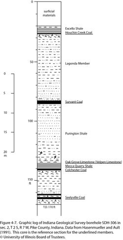
Core from Indiana Geological Survey borehole SDH-306, drilled east of Winslow in sec. 2, T 2 S, R 7 W, Pike County, Indiana. The limestone is 0.6 ft (18 cm) thick in the depth interval of 136.2 to 136.8 ft (41.5 to 41.7 m) in this core and directly overlies the Mecca Quarry Shale (Figure 4-7).
Reference author(s)
Hasenmueller and Ault (1991).
Reference status
In addition to the core description, gamma-ray and resistivity logs for SDH-306 are on file at the Indiana Geological Survey and can be downloaded from the Indiana Geological Survey website. The hole ID number is 115871. Core from SDH-306 resides at the Indiana Geological Survey core storage facility in Bloomington, Indiana, under call number 609.
Stratigraphic relationships
At its type and reference sections and elsewhere in Indiana, the Velpen Member directly overlies the Mecca Quarry Shale. Wier (1961) and Shaver et al. (1970, 1986) all acknowledged that the Velpen is the same as the Oak Grove Member in Illinois. Rexroad et al. (2001) concluded, based on a conodont investigation, that the Oak Grove Member in northern Illinois is slightly older than the Velpen Limestone in southern Indiana. If this is true, the limestone must be time transgressive because the Oak Grove and Velpen occupy precisely the same stratigraphic position.
Because the name Oak Grove (Wanless 1931) clearly has priority over Velpen, the latter name is hereby abandoned.
References
- Fuller, M.L. and G.H. Ashley, 1902, Ditney Folio, Indiana: U.S. Geological Survey, Geologic Atlas of the United States, Folio 84, 8 p., 7 pls., 1:125,000.
- Hasenmueller, W.A., and C.H. Ault, 1991, Reference core and correlation of key beds in the Petersburg and Linton Formations (Pennsylvanian) in Indiana: Indiana Geological Survey, Occasional Paper No. 57, 8 p.
- Rexroad, C.B., J.A. Wade, G.K. Merrill, L.M. Brown, and P. Padgett, 2001, Conodont biostratigraphy and depositional environments of the Mecca Quarry Shale Member and the Velpen Limestone Member of the Linton Formation (Pennsylvanian, Desmoinesian) in the eastern part of the Illinois Basin, USA: Indiana Geological Survey, Special Report 63, 19 p.
- Shaver, R.H., Ann M. Burger, G.R. Gates, H.H. Gray, H.C. Hutchison, S.J. Keller, J.B. Patton, C.B. Rexroad, N.M. Smith, W.J. Wayne, and C.E. Wier, 1970, Compendium of rock-unit stratigraphy in Indiana: Indiana Geological Survey, Bulletin 43, 229 p., 1 pl.
- Shaver, R.H., C. H. Ault, A.M. Burger, D.D. Carr, J.B. Droste, D.L. Eggert, H.H. Gray, D. Harper, N.R. Hasenmueller, W.A. Hasenmueller, A.S. Horowitz, H.C. Hutchison, B. Keith, S.J. Keller, J.B. Patton, C.B. Rexroad, and C.E. Wier, 1986, Compendium of Paleozoic rock-unit stratigraphy in Indiana—A revision: Indiana Geological Survey, Bulletin 59, 203 p.
- Wanless, H.R., 1931, Pennsylvanian cycles in western Illinois: Illinois State Geological Survey, Bulletin 60, p. 179–193.
- Wier, C.E. 1961, Stratigraphy of the Carbondale and McLeansboro Groups in southwestern Indiana: Indiana Geological Survey, unpublished bulletin, 147 p. and unnumbered appendix, http://hdl.handle.net/2022/3612 (accessed October 5, 2020).
ISGS Codes
| Stratigraphic Code | Geo Unit Designation |
|---|---|
"--" is not a number.
