Template:Galatia Channel Page
Figures and Plates
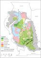
Figure 1 Map of the Illinois Basin showing the extent of Pennsylvanian rocks, thickness of the Springfield Coal, and channels interrupting the coal. From Finley et al. (2005)'"`UNIQ--ref-00000001-QINU`"'. Straight lines separating polygons are artifacts of mapping protocol in original.
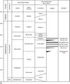
Figure 2 Correlation chart showing the positions of key units within the Pennsylvanian Subsystem. Global and provincial stage boundaries and ages in millions of years (Ma) are after Gradstein et al. (2012)'"`UNIQ--ref-00000001-QINU`"'.
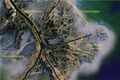
Figure 3 Satellite image of the mouth of the Mississippi River showing natural levees and crevasse splays. Fron Earthstar Geographic SIO, © 2020.
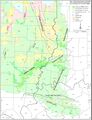
Plate 1 Map of the southeastern part of the Illinois Basin showing the thickness of the Springfield Coal, channels that affect the coal, and major structural features


Primary Source
W. John Nelson, Scott D. Elrick, William A. DiMichele, and Philip R. Ames xxxx, Evolution of a Peat-Contemporaneous Channel: The Galatia Channel, Middle Pennsylvanian, of the Illinois Basin FINISH CITATION