Search results
Jump to navigation
Jump to search
Page title matches
File:Figure M-49.jpg (1,080 × 1,070 (228 KB)) - 14:29, 4 April 2016
File:Figure M-27.jpg (2,261 × 3,052 (848 KB)) - 14:10, 4 April 2016
File:Figure M-38.jpg (1,067 × 1,596 (245 KB)) - 14:21, 4 April 2016
File:Figure M-6.jpg (1,073 × 2,715 (325 KB)) - 13:24, 4 April 2016
File:Figure M-17.jpg (1,077 × 1,486 (251 KB)) - 14:01, 4 April 2016
File:Figure M-28.jpg (2,245 × 3,047 (718 KB)) - 14:12, 4 April 2016
File:Figure M-39.jpg (1,073 × 1,434 (210 KB)) - 14:22, 4 April 2016
File:Figure M-7.jpg (3,183 × 1,092 (391 KB)) - 13:25, 4 April 2016
File:Figure M-18.jpg (1,076 × 1,464 (254 KB)) - 14:01, 4 April 2016
File:Figure M-50.jpg (1,078 × 1,088 (223 KB)) - 14:29, 4 April 2016
File:Figure M-29.jpg (1,794 × 3,419 (687 KB)) - 14:12, 4 April 2016
File:Figure M-8.jpg (1,085 × 1,561 (400 KB)) - 13:30, 4 April 2016
File:Figure M-40.jpg (1,065 × 1,454 (235 KB)) - 14:22, 4 April 2016
File:Figure M-19.jpg (1,088 × 1,279 (285 KB)) - 14:02, 4 April 2016
File:Figure M-1A.jpg (2,000 × 1,481 (736 KB)) - 18:44, 4 April 2016
File:Figure M-30.jpg (3,272 × 1,753 (891 KB)) - 14:14, 4 April 2016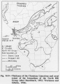
File:Figure M-9.jpg (1,089 × 1,515 (259 KB)) - 13:53, 4 April 2016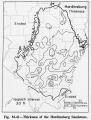
File:Figure M-41.jpg (1,080 × 1,422 (249 KB)) - 14:23, 4 April 2016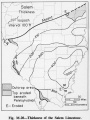
File:Figure M-20.jpg (1,077 × 1,431 (248 KB)) - 14:03, 4 April 2016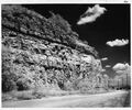
File:Figure M-1B.jpg (2,000 × 1,664 (653 KB)) - 18:47, 4 April 2016


Page text matches
File:C605-Figure-09.jpg |File name=C605-Figure-09.jpg |image_no=Figure 9(1,578 × 1,585 (969 KB)) - 15:54, 11 July 2020
File:Penn caseyville 2-6.jpg Figure 2-6. Graphic section at the Sellers Landing locality. Compiled from field n(1,587 × 2,727 (886 KB)) - 16:19, 20 July 2020
File:C605-Figure-27.jpg |File name=C605-Figure-27.jpg |image_no=Figure 27(1,418 × 1,307 (196 KB)) - 15:59, 17 August 2023
File:Penn carbondale 4-13.jpg |Caption=Figure 4-13. Graphic log of the upper part of the Kentucky Geological Survey’s(1,059 × 3,660 (466 KB)) - 21:07, 26 January 2021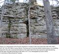
File:Penn caseyville 2-8.jpg Figure 2-8. Photograph of the Pounds Sandstone in Garden of the Gods State Park (S(2,201 × 2,002 (4.3 MB)) - 21:37, 24 November 2020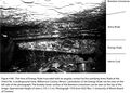
File:Penn carbondale 4-80.jpg |Caption=Figure 4-80. Thin lens of Energy Shale truncated with an angular contact by the o(2,441 × 1,741 (1.54 MB)) - 21:38, 4 January 2021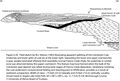
File:Penn carbondale 4-20.jpg |Caption=Figure 4-20. Field sketch by W.J. Nelson (1983) illustrating apparent splitting o(2,391 × 1,614 (778 KB)) - 21:44, 22 December 2020


