File list
Jump to navigation
Jump to search
This special page shows all uploaded files.
| Date | Name | Thumbnail | Size | User | Description | Versions |
|---|---|---|---|---|---|---|
| 17:16, 18 April 2016 | 94-tb 6-b.jpg (file) |  |
561 KB | Illex-gron | 1 | |
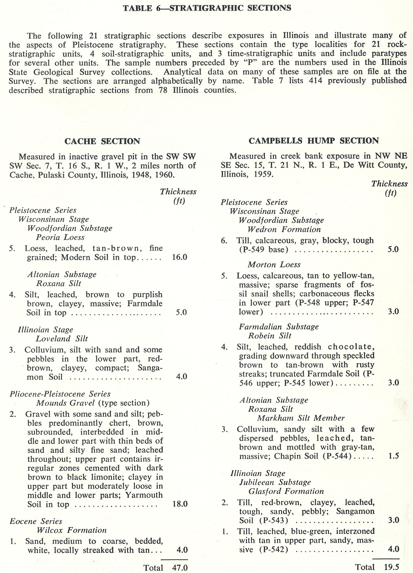
| 17:15, 18 April 2016 | 94-tb 6-a.jpg (file) |  |
546 KB | Illex-gron | Table 6 -- Stratigraphic Sections | 1 |
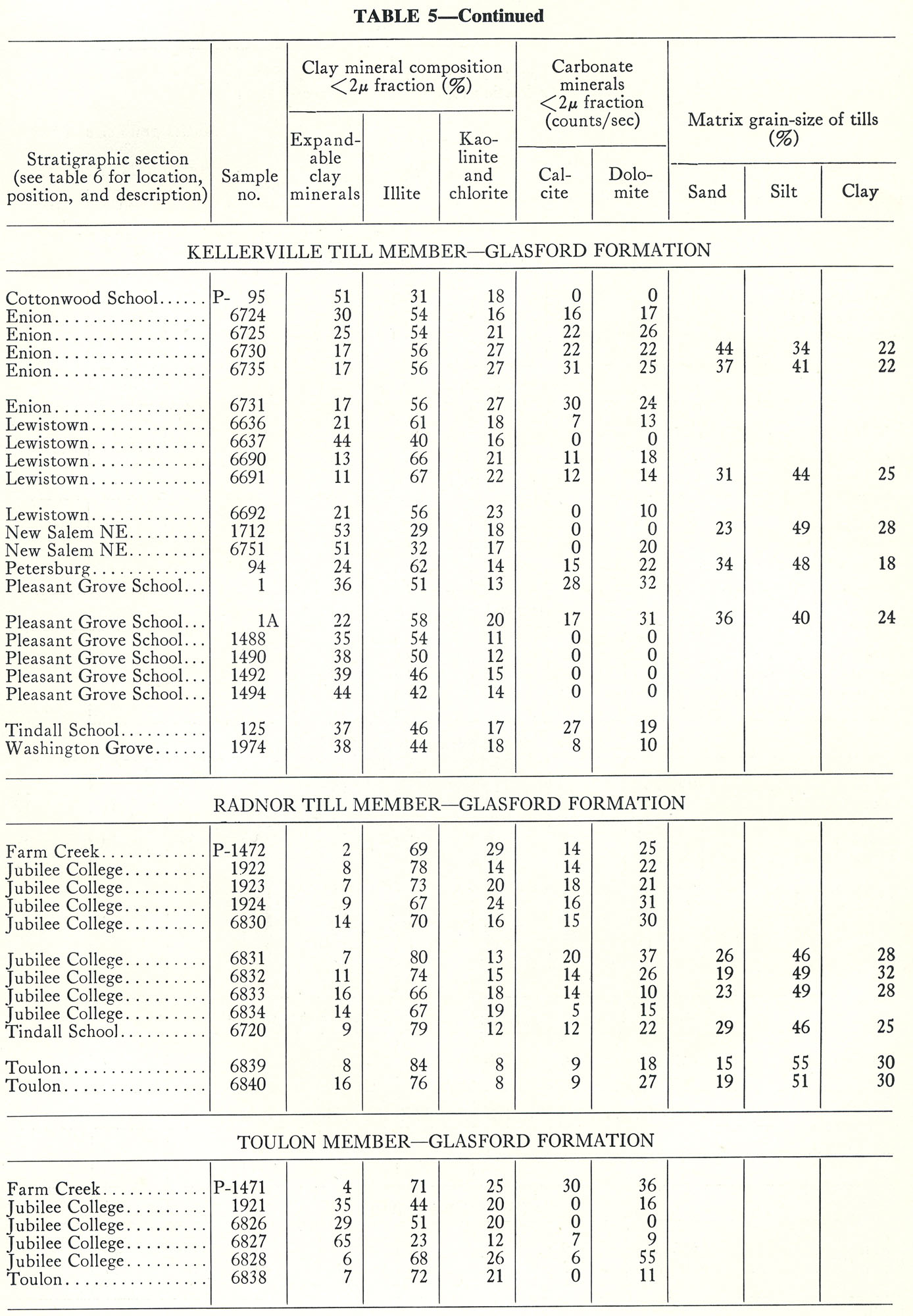
| 17:13, 18 April 2016 | 94-tb 5-e.jpg (file) |  |
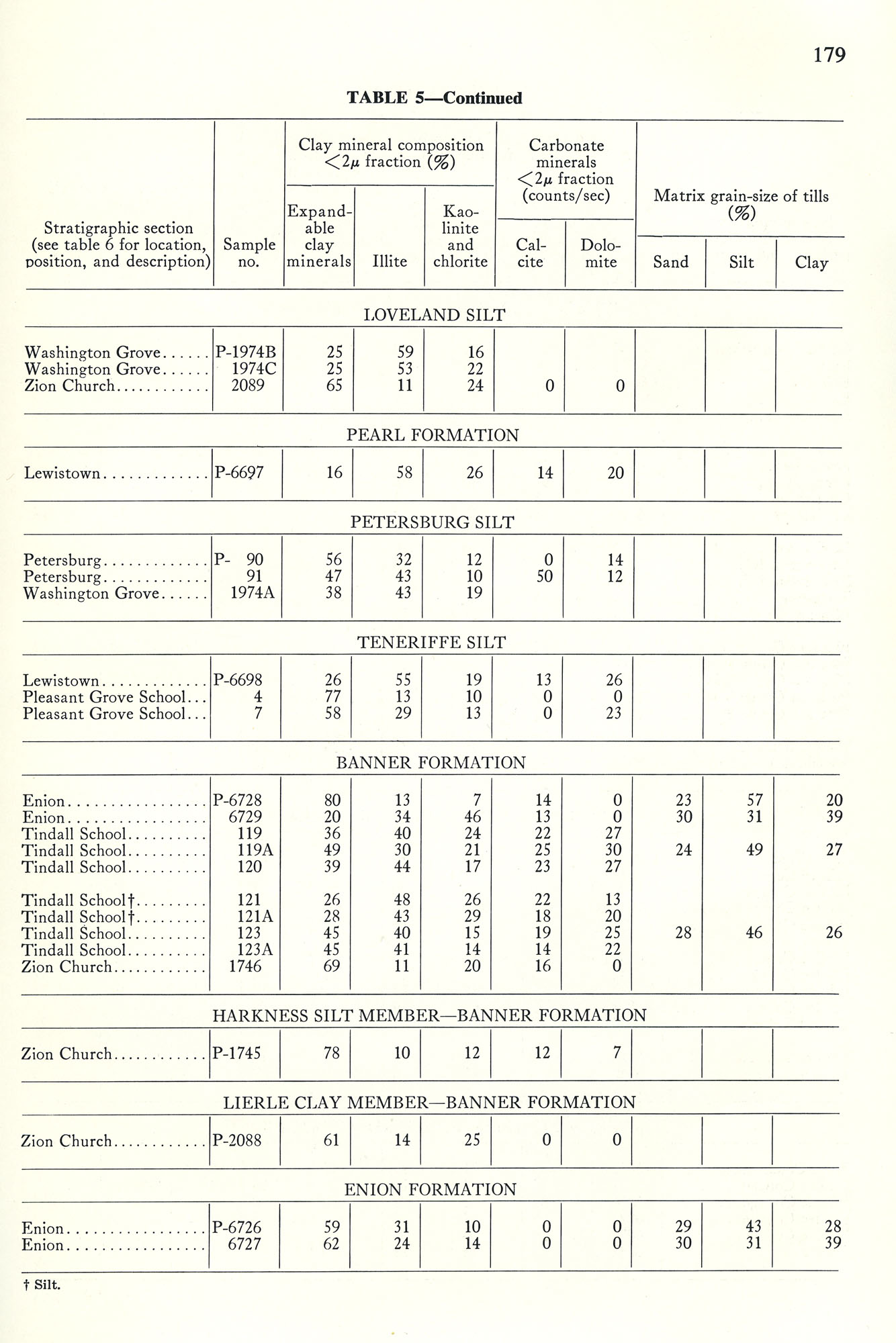
449 KB | Illex-gron | Table 5 -- Continued. | 1 |
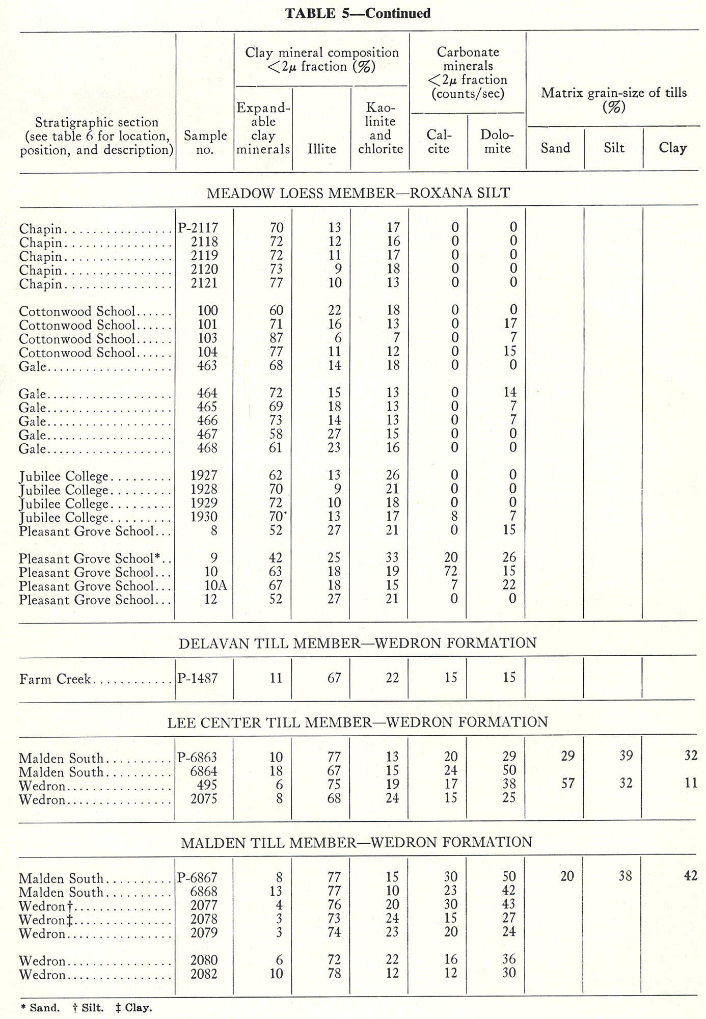
| 17:12, 18 April 2016 | 94-tb 5-d.jpg (file) |  |
414 KB | Illex-gron | Table 5 -- Continued. | 1 |
| 17:11, 18 April 2016 | 94-tb 5-c.jpg (file) |  |
414 KB | Illex-gron | Table 5 -- Continued. | 1 |
| 17:11, 18 April 2016 | 94-tb 5-b.jpg (file) |  |
404 KB | Illex-gron | Table 5 - Continued. | 1 |
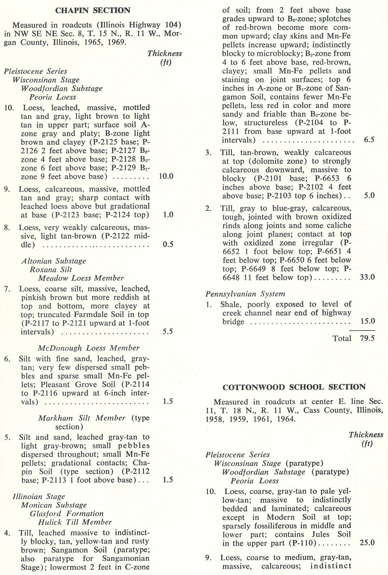
| 17:10, 18 April 2016 | 94-tb 5-a.jpg (file) |  |
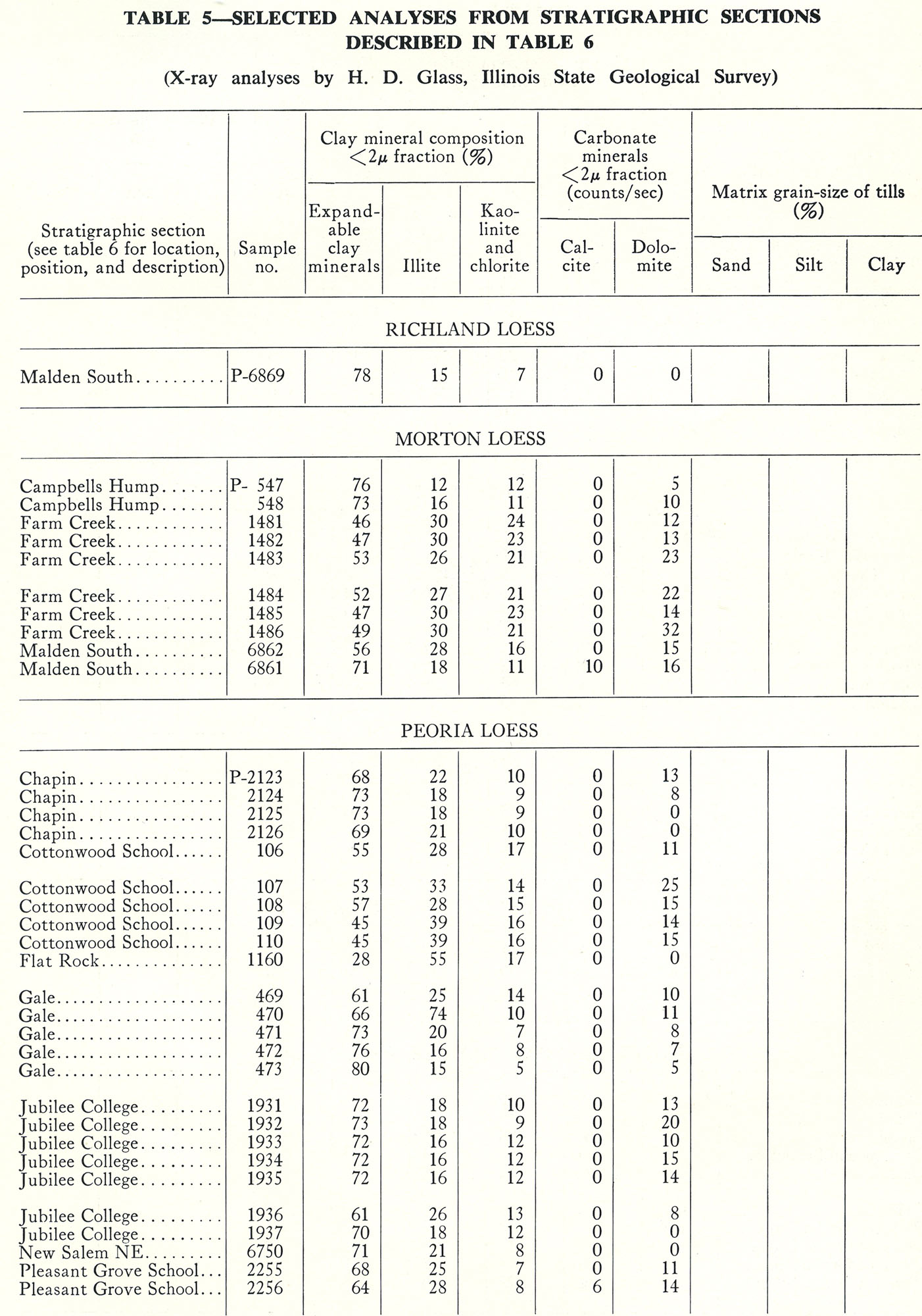
410 KB | Illex-gron | Table 5 -- Selected Analyses from Stratigraphic Sections Described in Table 6 (X-ray analyses by H. D. Glass, Illinois State Geological Survey). | 1 |
| 17:01, 18 April 2016 | 94-tb 5-.jpg (file) |  |
358 KB | Illex-gron | Table 5 -- Continued. | 1 |
| 16:59, 18 April 2016 | 94-tb 4.jpg (file) |  |
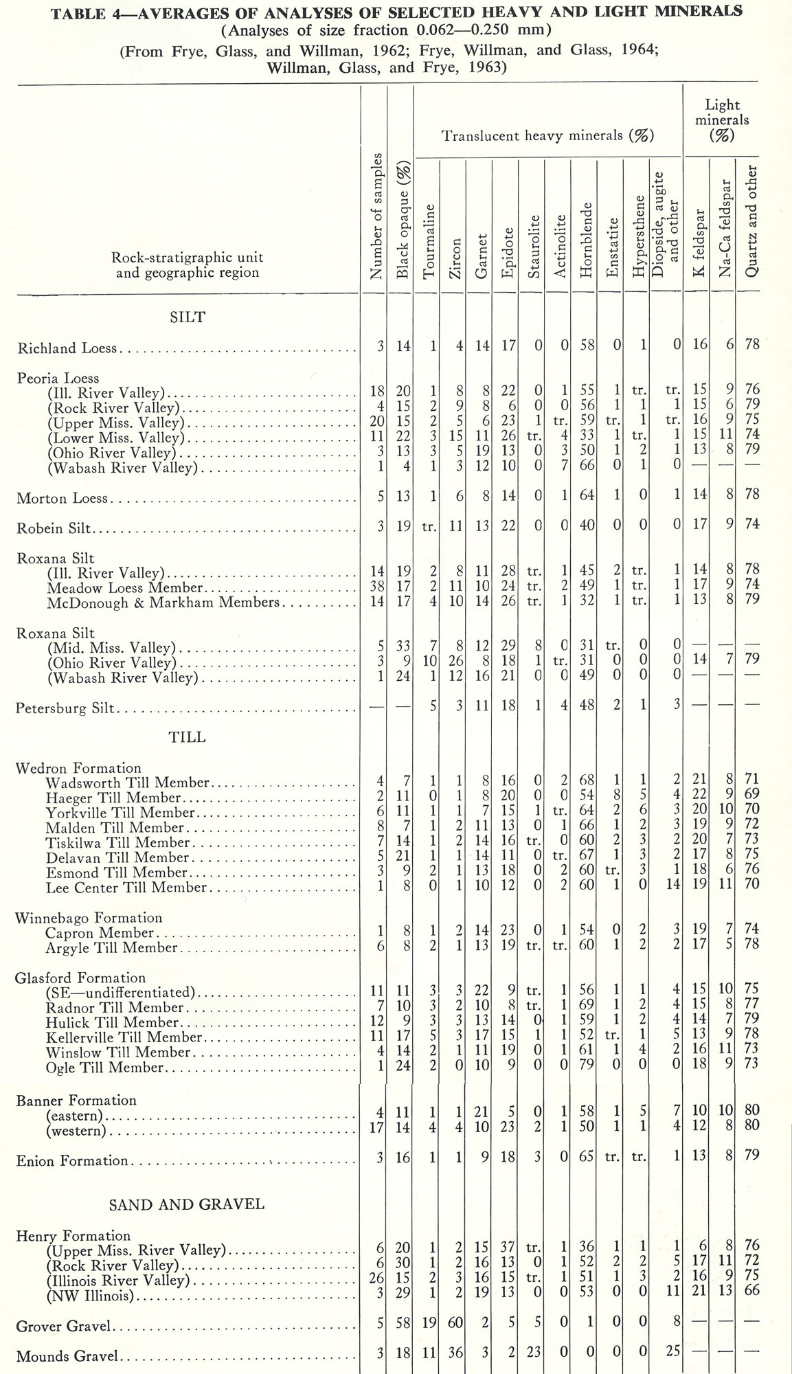
452 KB | Illex-gron | Table 4 -- Averages of Analyses of Selected Heavy and Light Minerals (Analyses of size fraction 0.062-0.250 mm). (From Frye, Glass, and Willman, 1962; Frye, Willman, and Glass, 1964; Willman, Glass, and Frye, 1963) | 1 |
| 16:57, 18 April 2016 | 94-tb 3.jpg (file) |  |
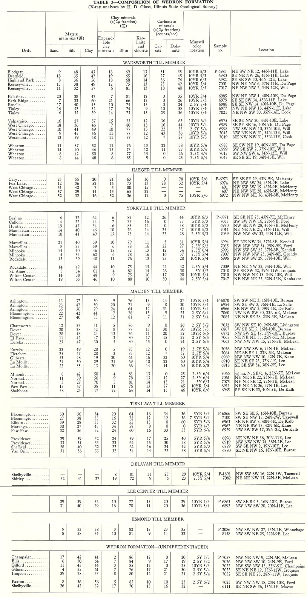
516 KB | Illex-gron | Table 3 -- Composition of Wedron Formation (X-ray analyses by H. D. Glass, Illinois State Geological Survey). | 1 |
| 16:55, 18 April 2016 | 94-tb 2.jpg (file) |  |
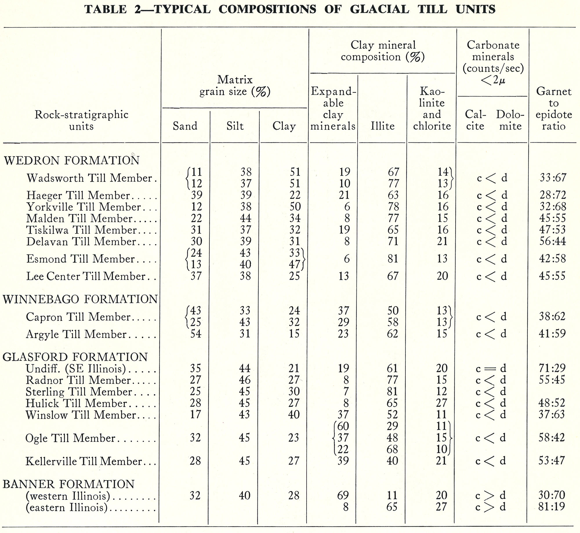
508 KB | Illex-gron | Table 2 -- Typical Compositions of Glacial Till Units. | 1 |
| 16:54, 18 April 2016 | 94-tb 1.jpg (file) |  |
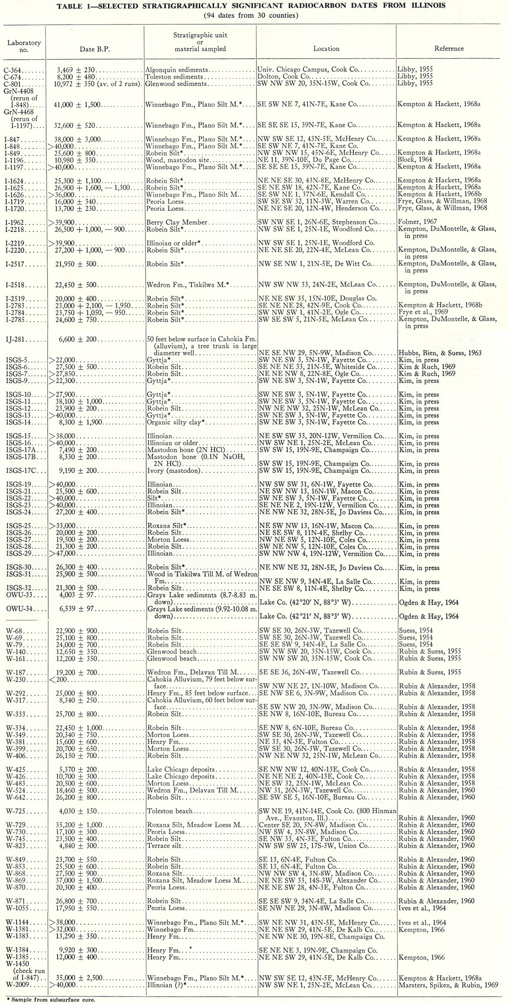
657 KB | Illex-gron | Table 1 -- Selected Stratigraphically Significant Radiocarbon Dates From Illinois (94 dates from 30 counties). | 1 |
| 16:52, 18 April 2016 | 94-pl 3.jpg (file) |  |
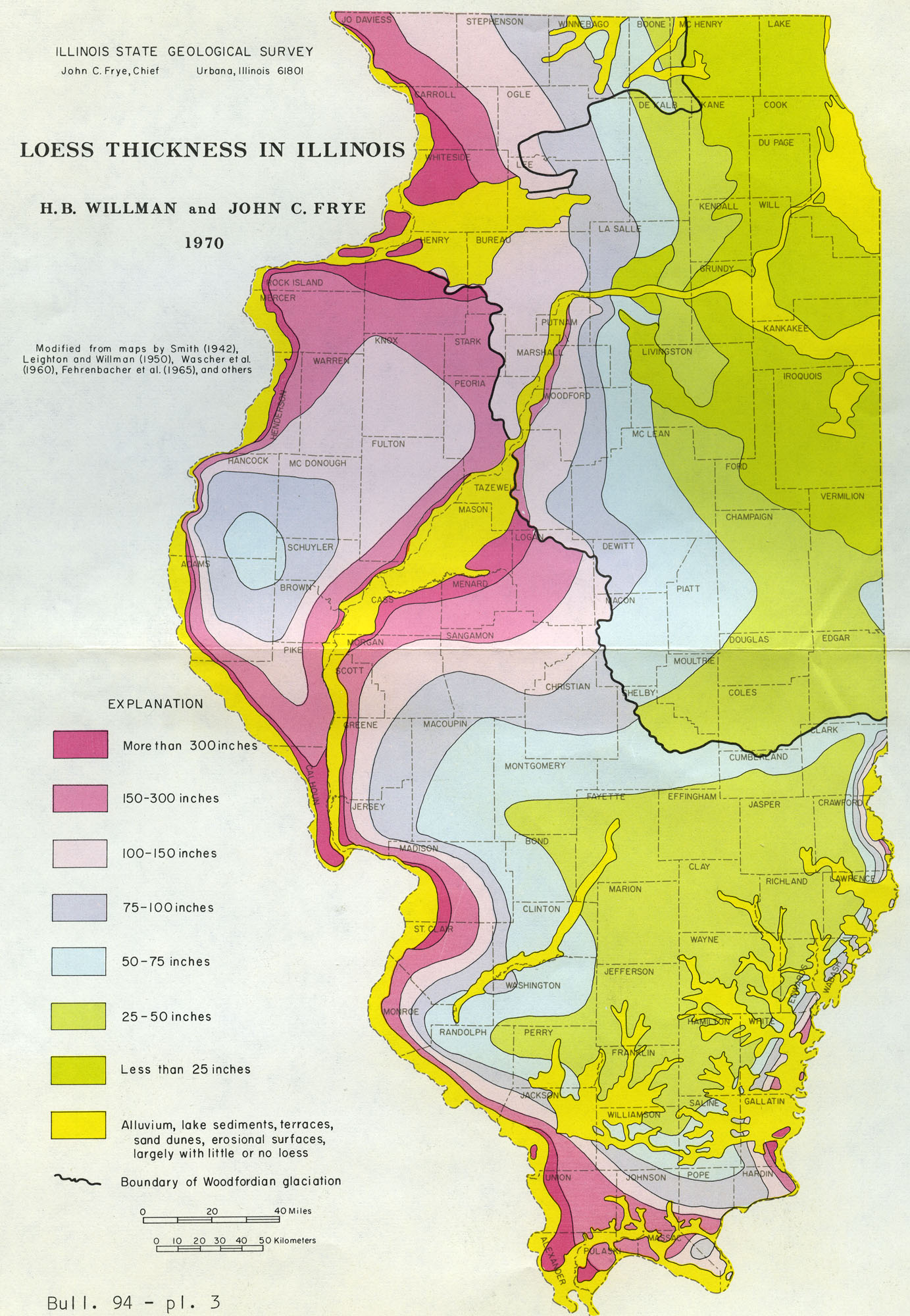
587 KB | Illex-gron | Bull. 94 - pl. 3 | 1 |
| 16:48, 18 April 2016 | 94-pl 2.jpg (file) |  |
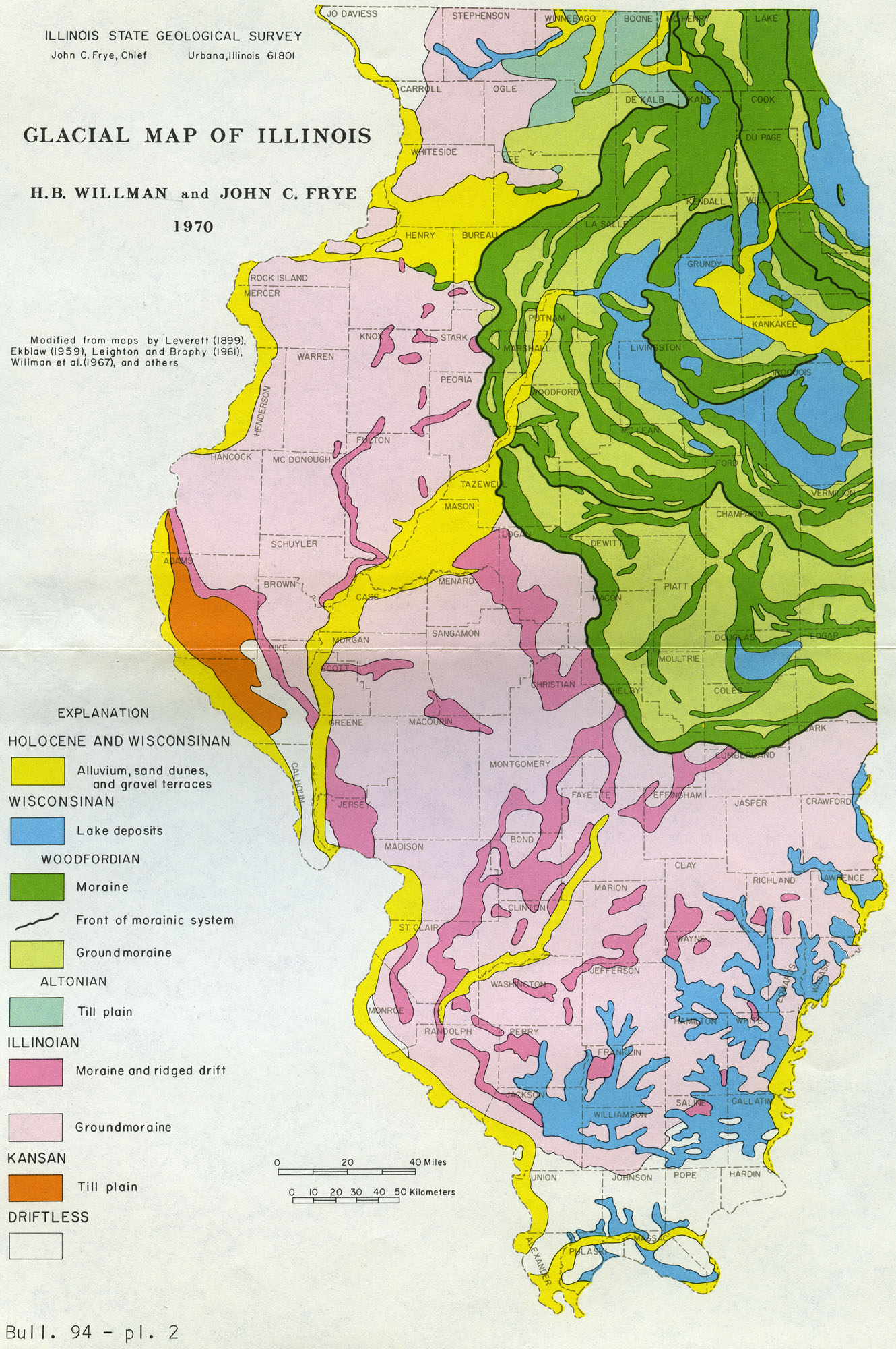
611 KB | Illex-gron | Bull. 94 - pl. 2 | 1 |
| 16:45, 18 April 2016 | 94-fig 14.jpg (file) |  |
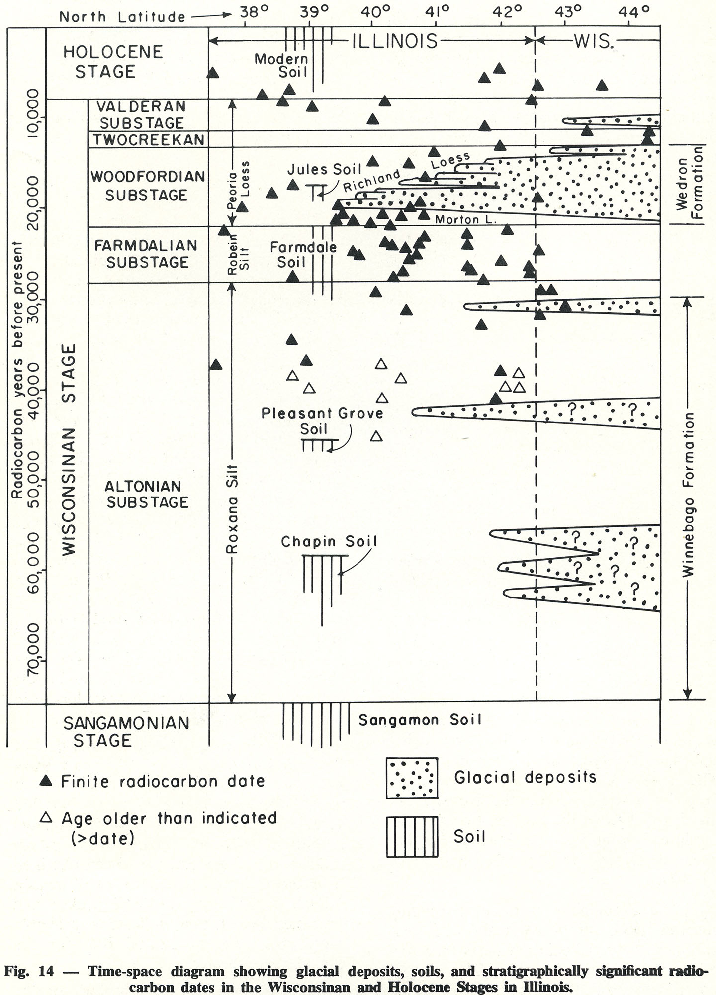
398 KB | Illex-gron | Fig. 14 -- Time-space diagram showing glacial deposits, soils, and stratigraphically significant radio-carbon dates in the Wisconsinan and Holocene Stages in Illinois. | 1 |
| 16:44, 18 April 2016 | 94-fig 13.jpg (file) |  |
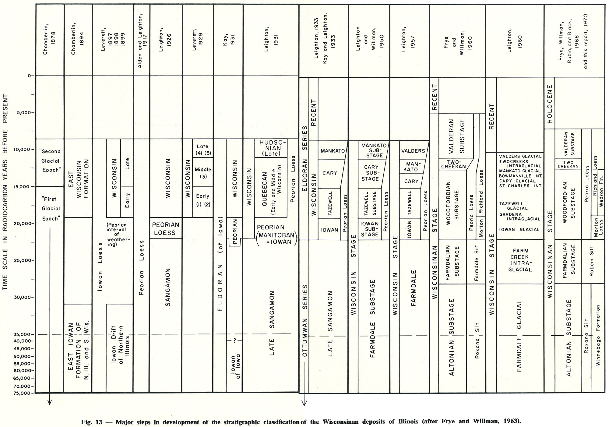
431 KB | Illex-gron | Fig. 13 -- Major steps in development of the stratigraphic classification of the Wisconsinan deposits of Illinois (after Frye and Willman, 1963). | 1 |
| 16:42, 18 April 2016 | 94-fig 12.jpg (file) |  |
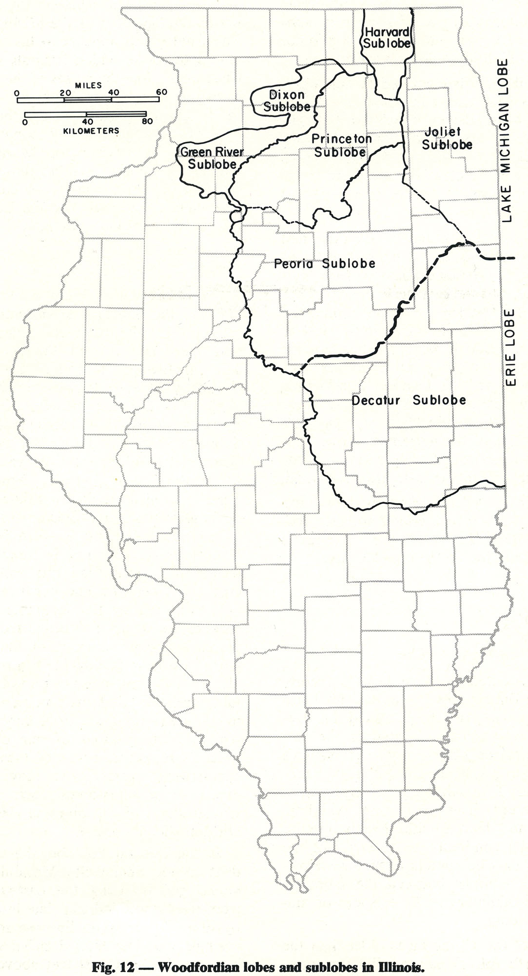
290 KB | Illex-gron | Fig. 12 -- Woodfordian lobes and sublobes in Illinois. | 1 |
| 16:41, 18 April 2016 | 94-fig 11.jpg (file) |  |
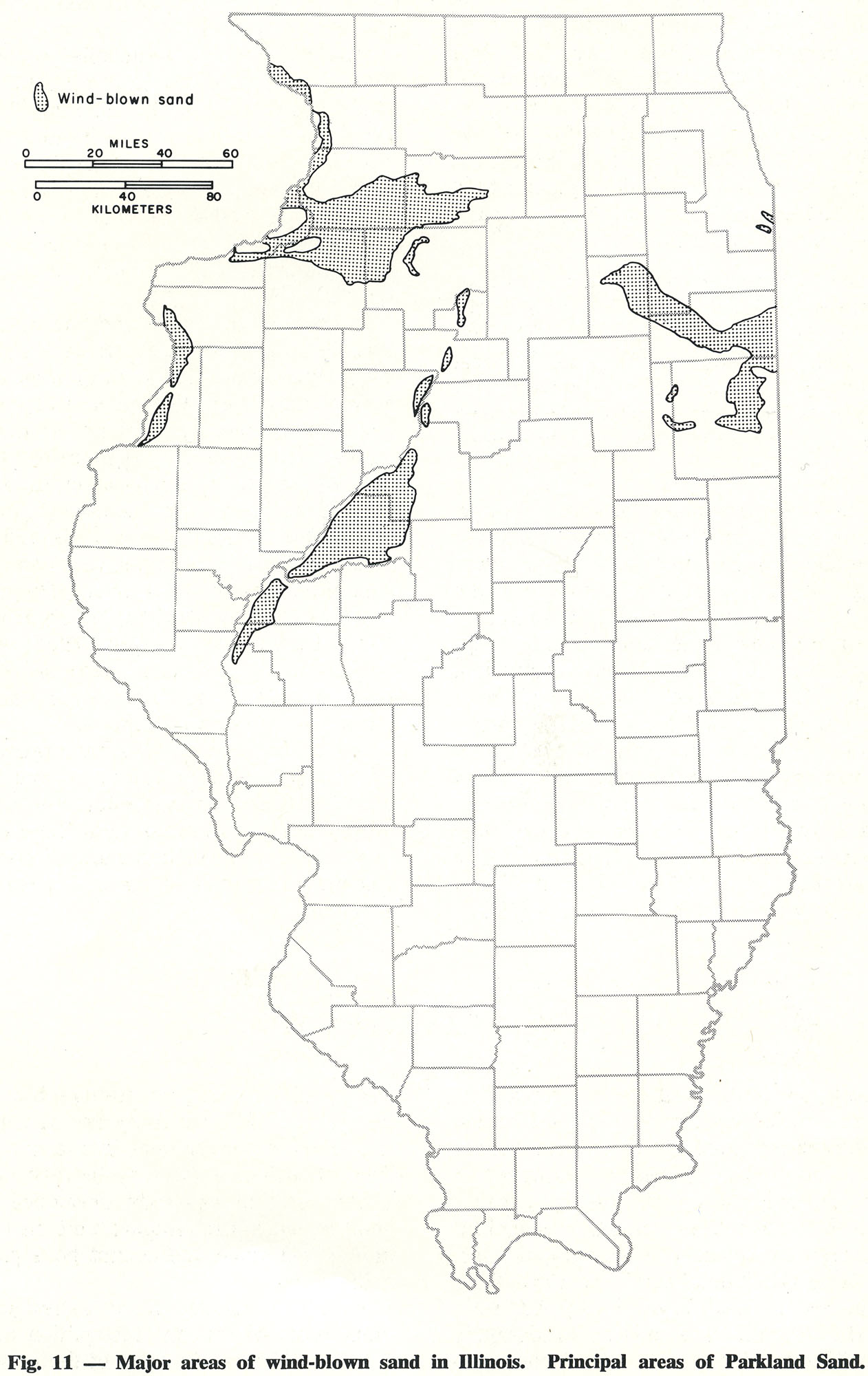
309 KB | Illex-gron | Fig. 11 -- Major areas of wind-blown sand in Illinois. Principal areas of Parkland Sand. | 1 |
| 16:40, 18 April 2016 | 94-fig 10.jpg (file) |  |
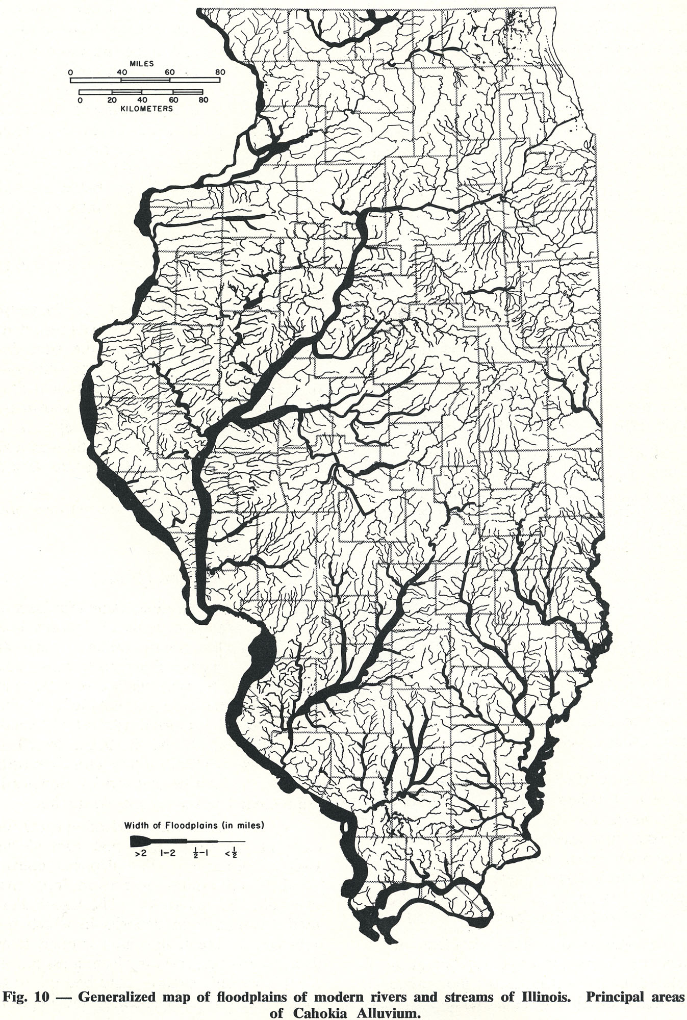
673 KB | Illex-gron | Fig. 10 -- Generalized map of floodplains of modern rivers and streams of Illinois. Principal areas of Cahokia Alluvium. | 1 |
| 16:38, 18 April 2016 | 94-fig 9.jpg (file) |  |
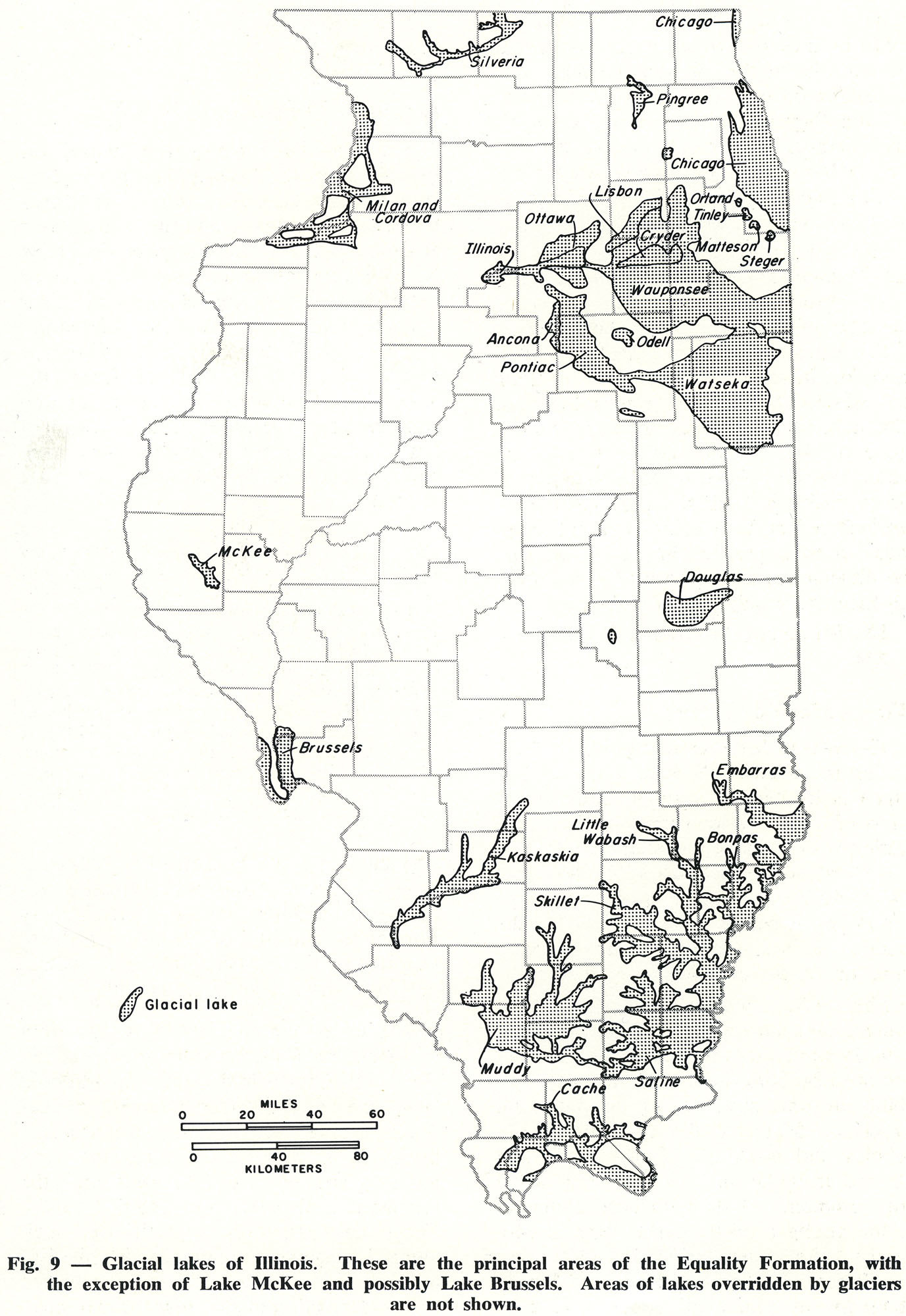
438 KB | Illex-gron | Fig. 9 -- Glacial lakes of Illinois. These are the principal areas of the Equality Formation, with the exception of Lake McKee and possibly Lake Brussels. Areas of lakes overridden by glaciers are not shown. | 1 |
| 16:32, 18 April 2016 | 94-fig 8.jpg (file) |  |
575 KB | Illex-gron | Fig. 8 -- Diagrammatic cross section showing the relations of formations and members of Wisconsinan age in northern and western Illinois. | 1 |
| 16:30, 18 April 2016 | 94-fig 7.jpg (file) |  |
567 KB | Illex-gron | Fig. 7 -- Diagrammatic cross section showing the relations of formations and members of Illinoian age in western Illinois. | 1 |
| 16:28, 18 April 2016 | 94-fig 6.jpg (file) |  |
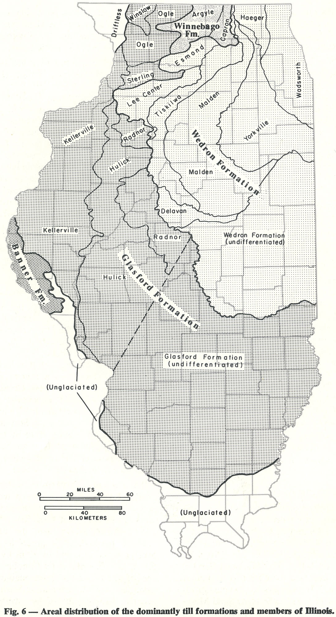
665 KB | Illex-gron | Fig. 6 -- Areal distribution of the dominantly till formations and members of Illinois. | 1 |
| 16:26, 18 April 2016 | 94-fig 5.jpg (file) |  |
399 KB | Illex-gron | Fig. 5 -- Sequence of glaciations and interglacial drainage in Illinois. | 1 |
| 16:21, 18 April 2016 | 94-fig 4.jpg (file) |  |
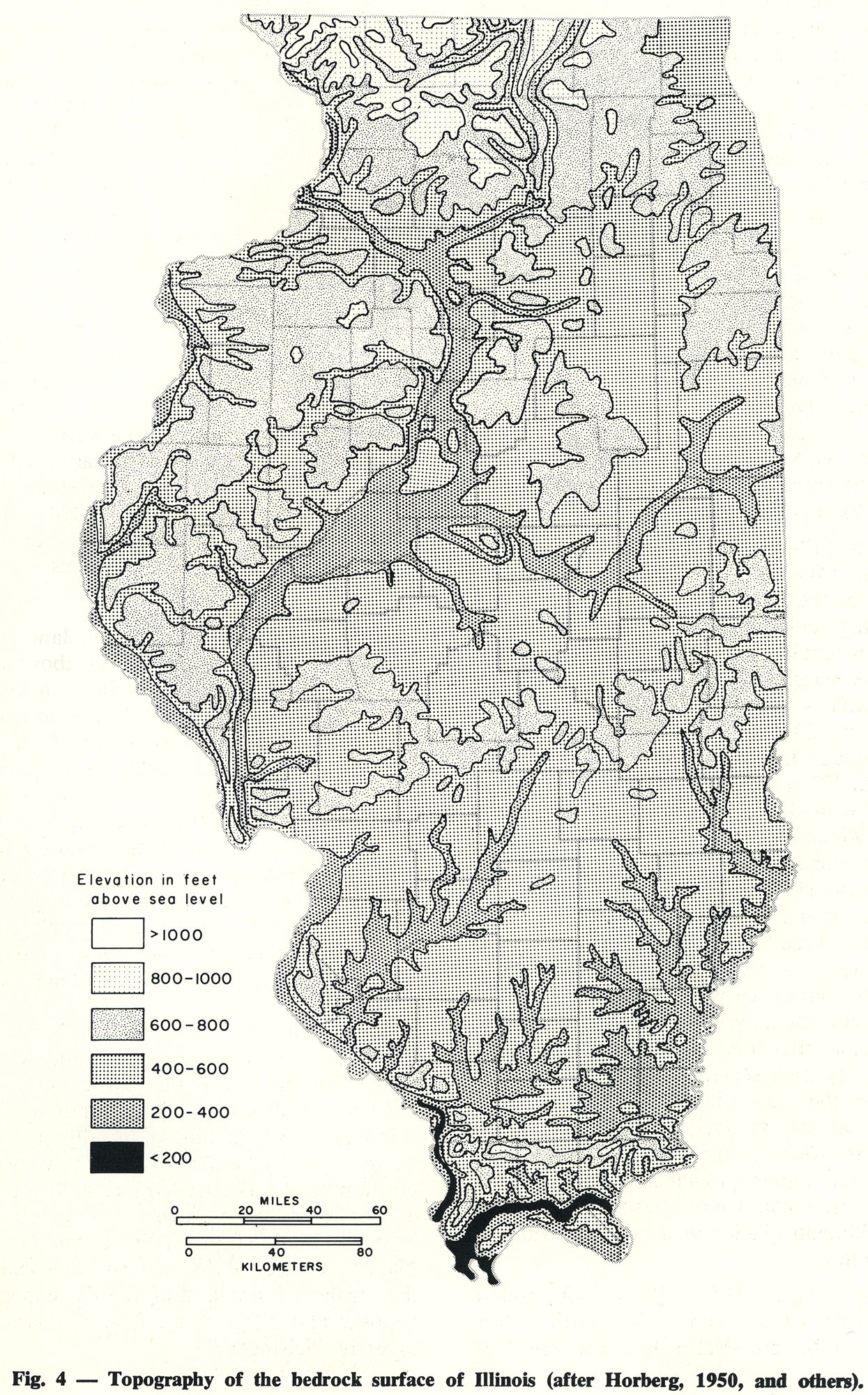
858 KB | Illex-gron | Fig. 4 -- Topography of the bedrock surface of Illinois (after Horberg, 1950, and others). | 1 |
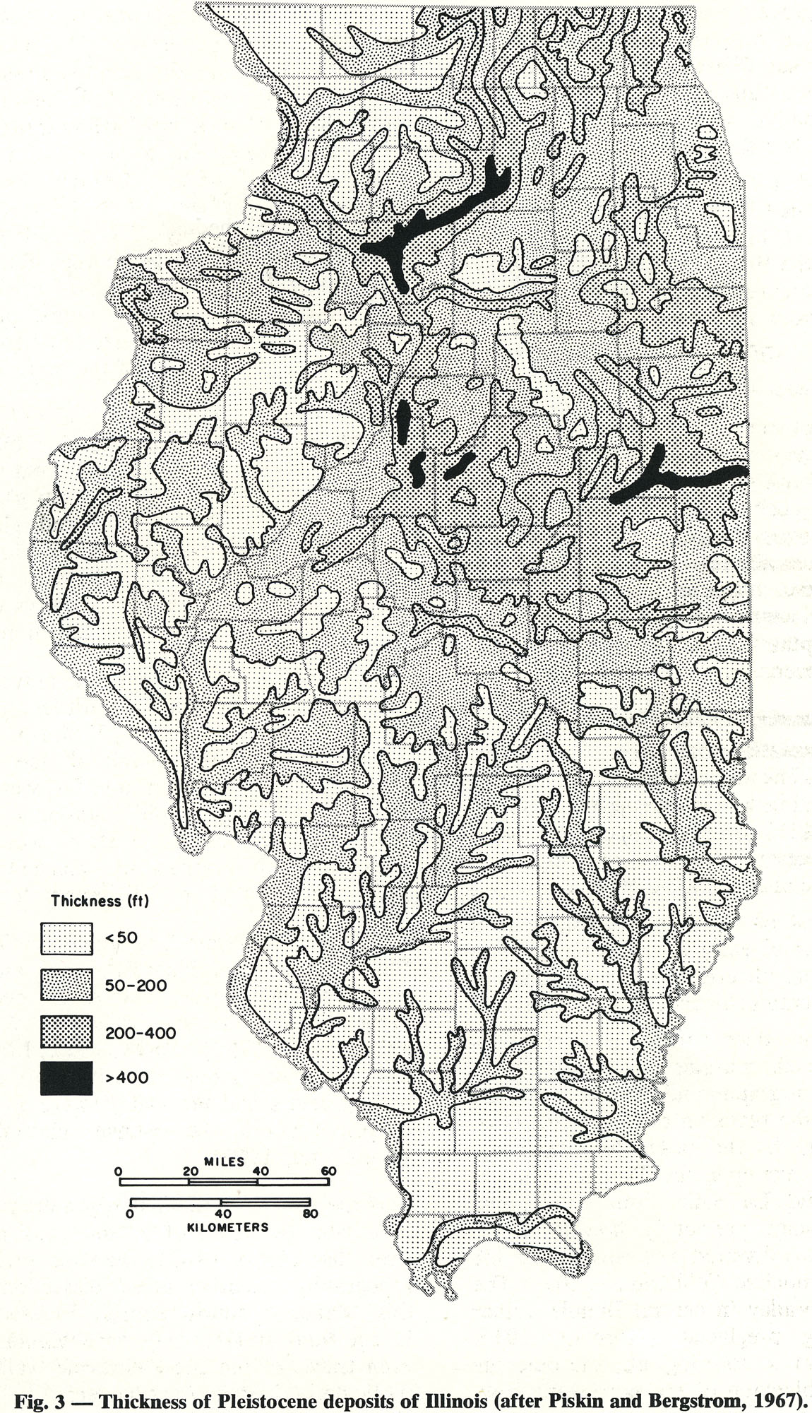
| 16:19, 18 April 2016 | 94-fig 3.jpg (file) |  |
876 KB | Illex-gron | Fig. 3 -- Thickness of Pleistocene deposits of Illinois (after Piskin and Bergstrom, 1967). | 1 |
| 16:15, 18 April 2016 | 94-fig 2.jpg (file) |  |
893 KB | Illex-gron | Fig. 2 -- Generalized areal geology of the bedrock surface of Illinois. (see Willman et at., 1967, for more detailed mapping). | 1 |
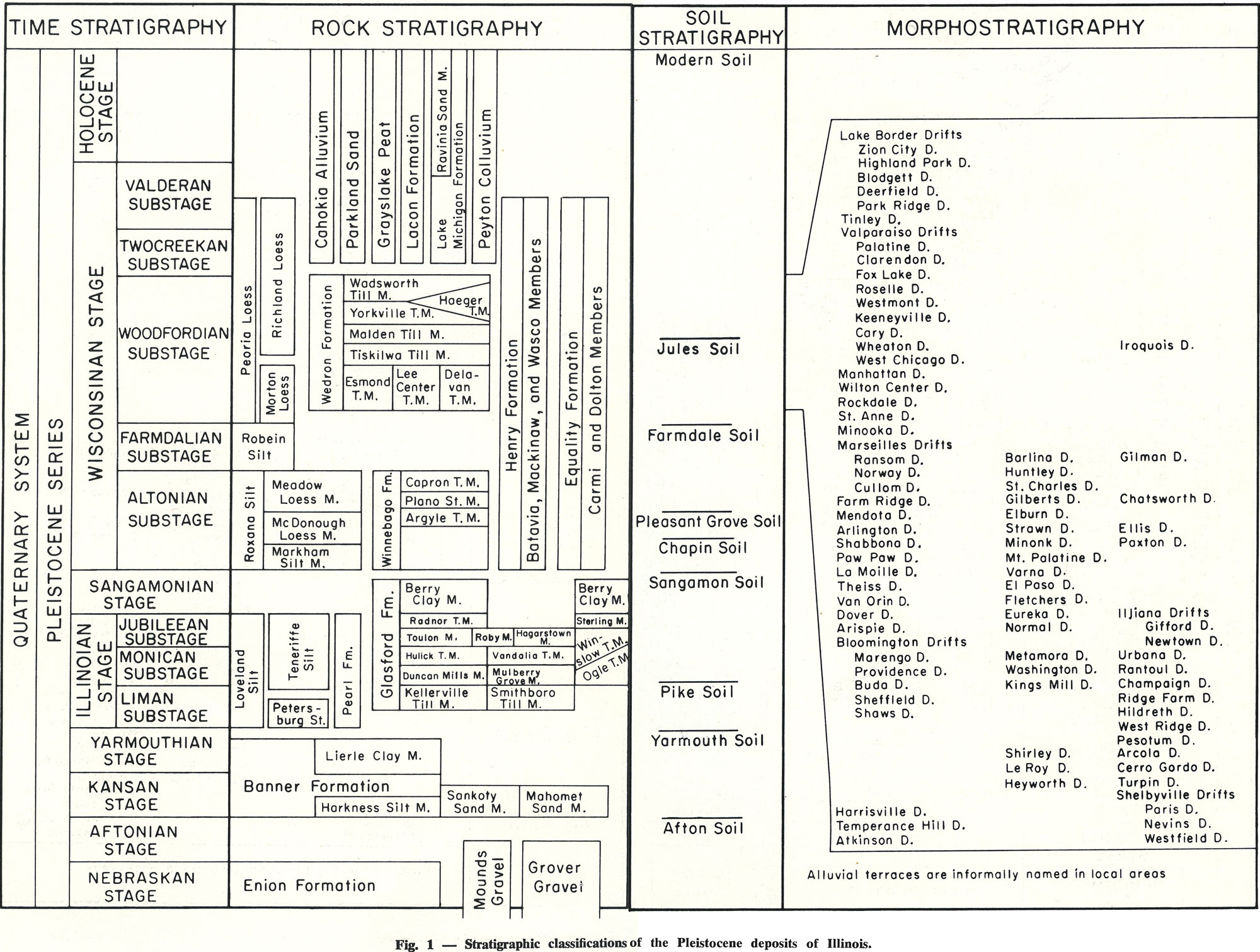
| 17:59, 13 April 2016 | 94-Fig 1.jpg (file) |  |
538 KB | Illex-gron | Fig. 1 -- Stratigraphic classification of the Pleistocene deposits of Illinois. | 1 |
| 16:24, 5 April 2016 | Figure Q-1C.jpg (file) |  |
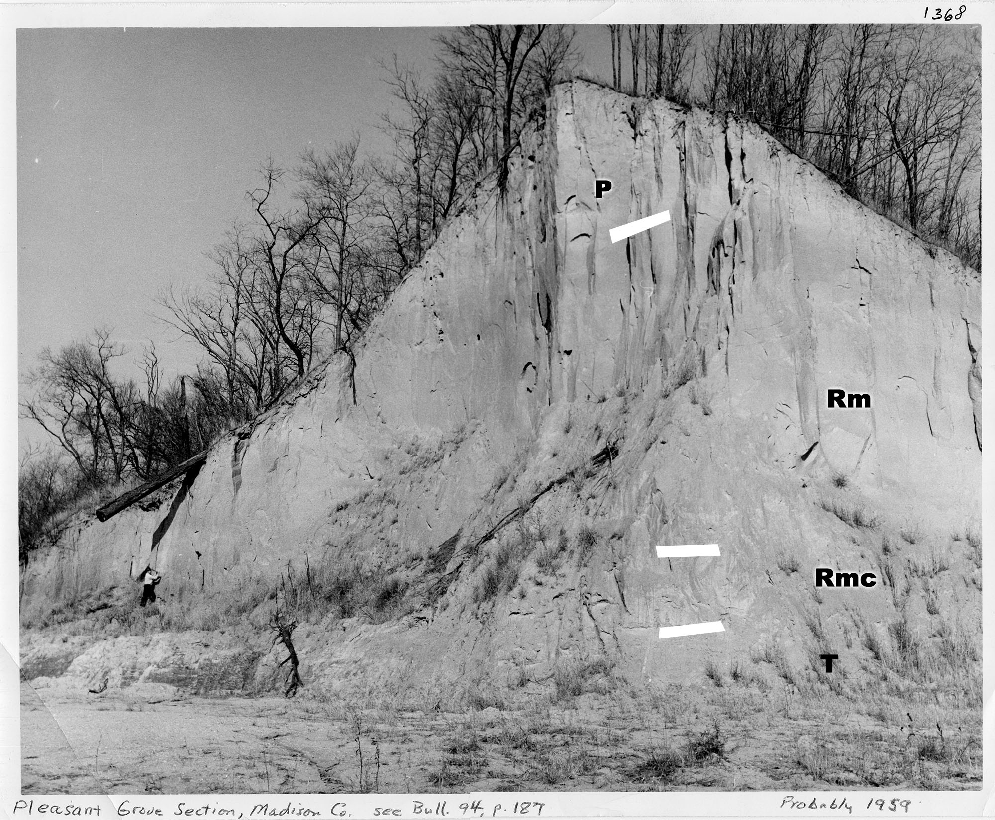
707 KB | Alan.Myers | Fig. Q-1C -- Wisconsinan Peoria Loess (P) overlying the Roxana Silt (Rm-Meadow Loess Member, Rmc-McDonough Loess Member) and the Illinoian Teneriffe Silt (T) in the Pleasant Grove School Section in the Mississippi River bluffs northwest of Collinsville... | 2 |
| 16:12, 5 April 2016 | Figure Q-1B.jpg (file) |  |
1.11 MB | Alan.Myers | Fig. Q-1B -- The Wisconsinan Wedron (W-interbedded till and outwash) and Peddicord (P-lake sediments) Formations overlying till of the Illinoian Glasford Formation in the Wedron Silica Company pit at Wedron, LaSalle County-the type sections of the Wedr... | 2 |
| 16:02, 5 April 2016 | Figure Q-1A.jpg (file) |  |
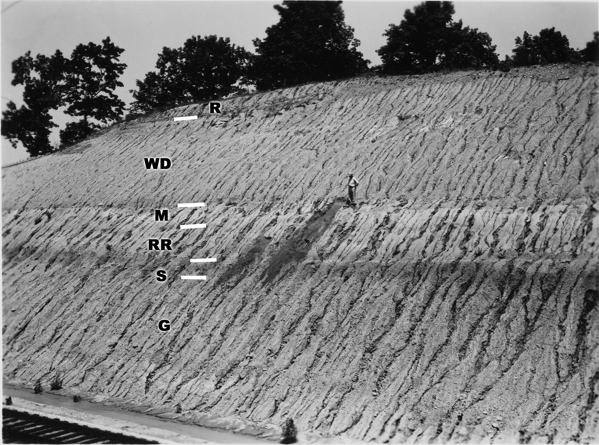
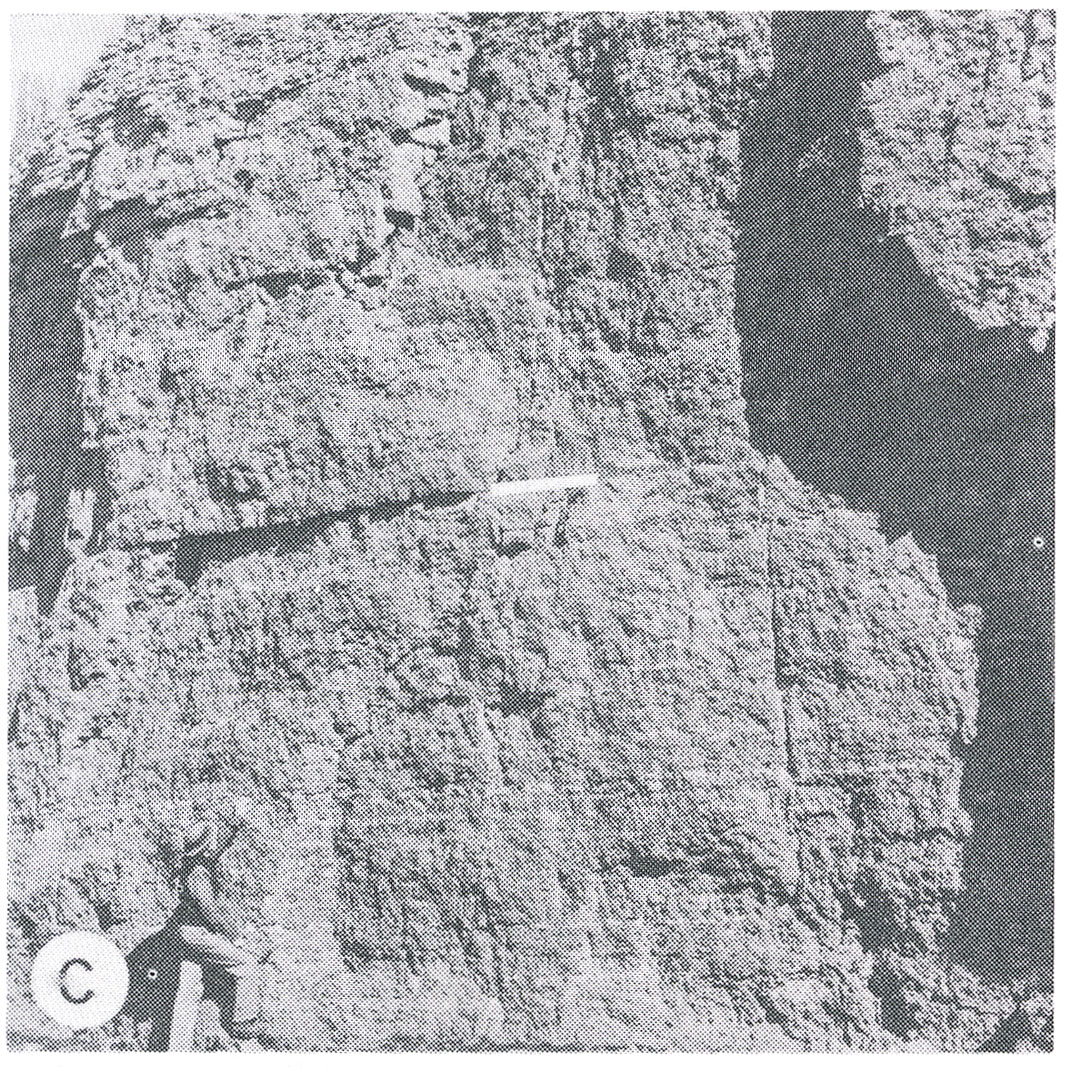
735 KB | Alan.Myers | Fig. Q-1A -- Wisconsinan Richland Loess (R), Delavan Till Member of the Wedron Formation (Wd), Morton Loess(M), Robein and Roxana Silts (RR), and the Sangamon Soil (S) on till of the Illinoian Glasford Formation(C); in a railroad cut a mile east of Far... | 2 |
| 13:22, 5 April 2016 | Figure S-2F.jpg (file) |  |
1.19 MB | Alan.Myers | Fig. S-2F -- Dense, argillaceous dolomite containing chert nodules characteristic of Racine interreef facies in the Chicago area. The outer, porous parts of the nodules are blackened by air pollutants. | 1 |
| 13:16, 5 April 2016 | Figure S-2E.jpg (file) |  |
1.26 MB | Alan.Myers | Fig. S-2E -- Mottled, porous, pure dolomite characteristic of Racine reef facies in the Chicago area (x 1). | 1 |
| 13:16, 5 April 2016 | Figure S-2D.jpg (file) |  |
1.46 MB | Alan.Myers | Fig. S-2D -- Massive Tete des Morts Formation overlying the Mosalem Formation at the top of Silurian escarpment, 4 miles southeast of Galena, Jo Daviess County. | 1 |
| 13:15, 5 April 2016 | Figure S-2C.jpg (file) |  |
1.38 MB | Alan.Myers | Fig. S-2C -- Massive Marcus Dolomite in a quarry 3 miles east of Fulton, Whiteside County. | 1 |
| 13:14, 5 April 2016 | Figure S-2B.jpg (file) |  |
1.29 MB | Alan.Myers | Fig. S-2B -- Steeply dipping, well bedded dolomite forming the fiank of a Racine (Niagaran) reef, in the Material Service Corporation quarry at Thornton, Cook County. | 1 |
| 13:14, 5 April 2016 | Figure S-2A.jpg (file) |  |
1.33 MB | Alan.Myers | Fig. S-2A -- Massive dolomite in the core of a Racine (Niagaran) reef, at the top of the Material Service Corporation (Stearns) quarry on Archer Avenue at 28th Street, Chicago. | 1 |
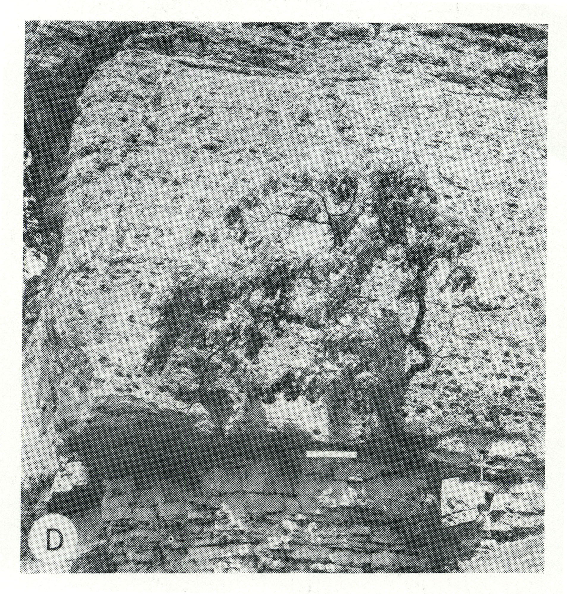
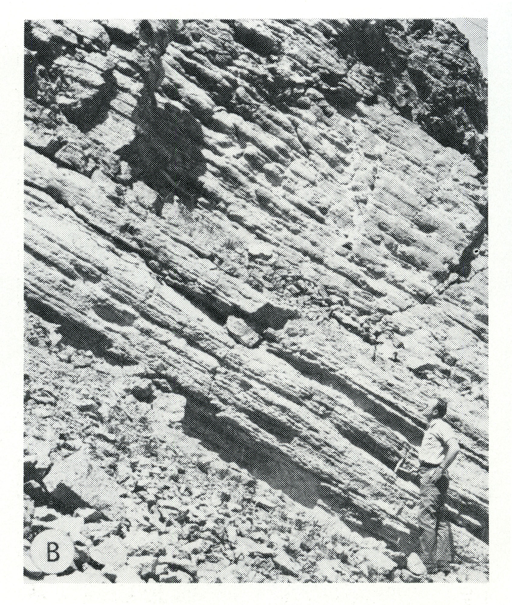
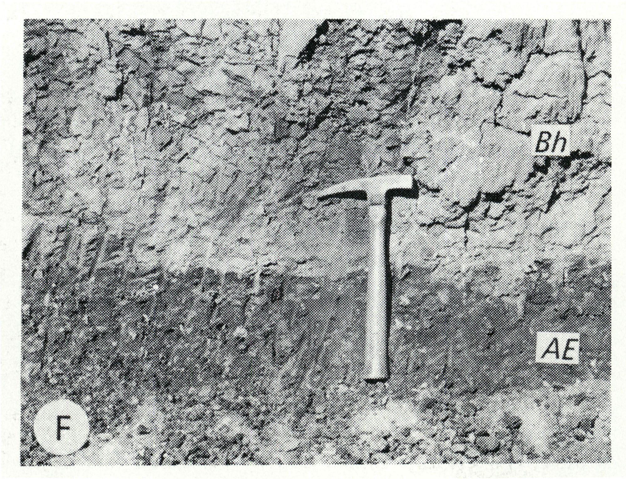
| 13:12, 5 April 2016 | Figure Q-1F.jpg (file) |  |
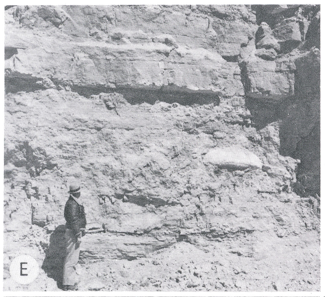
1.13 MB | Alan.Myers | Fig. Q-1F -- Harkness Silt Member of the ~ansan Banner Formation (Bh) overlying the Afton Soil developed on gravel of the Nebraskan Enion Formation (AE); in a roadcut at the Zion Church, 2 miles southeast of Marblehead, Adams County (Willman and Frye,... | 1 |
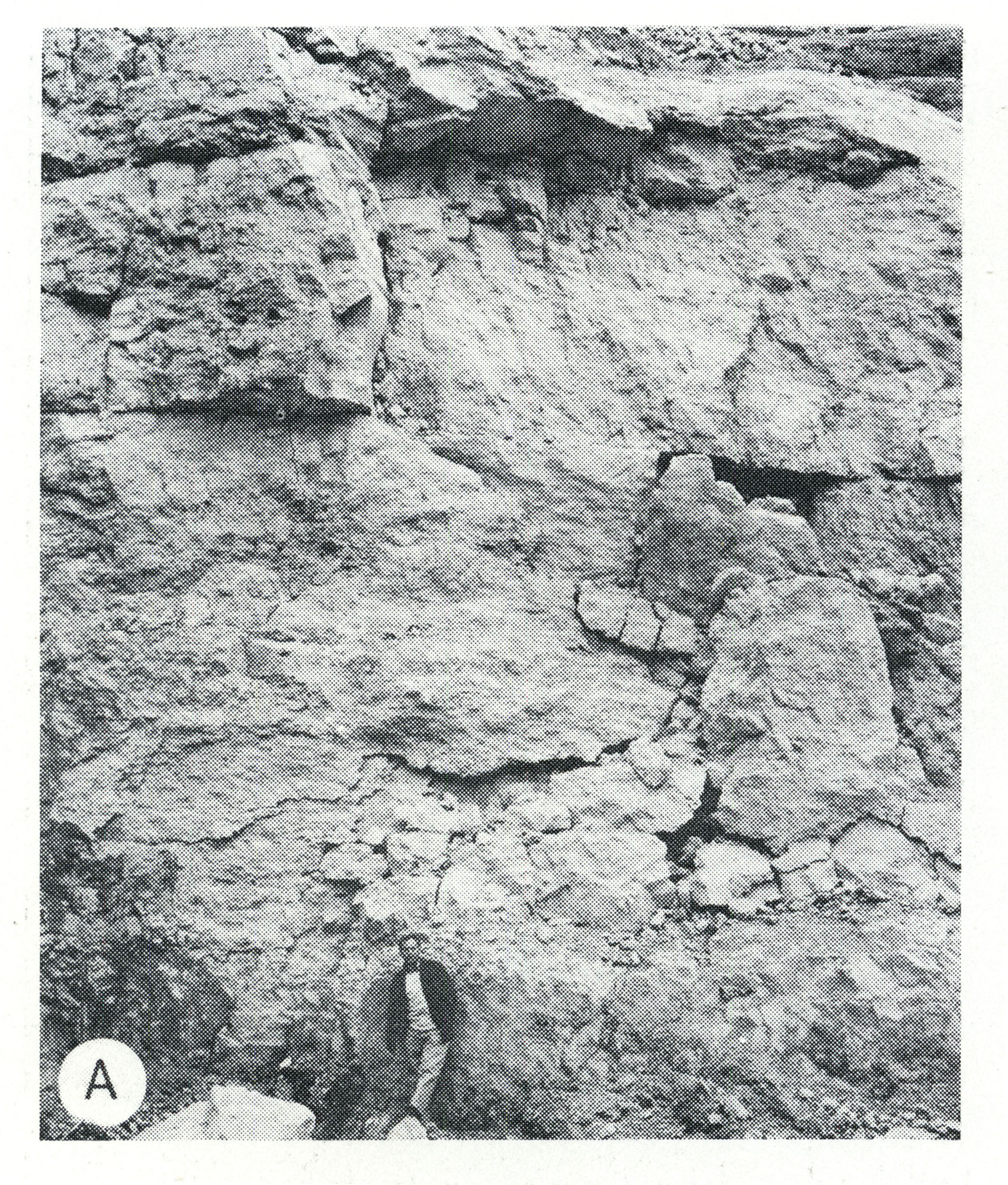
| 13:11, 5 April 2016 | Figure Q-1E.jpg (file) |  |
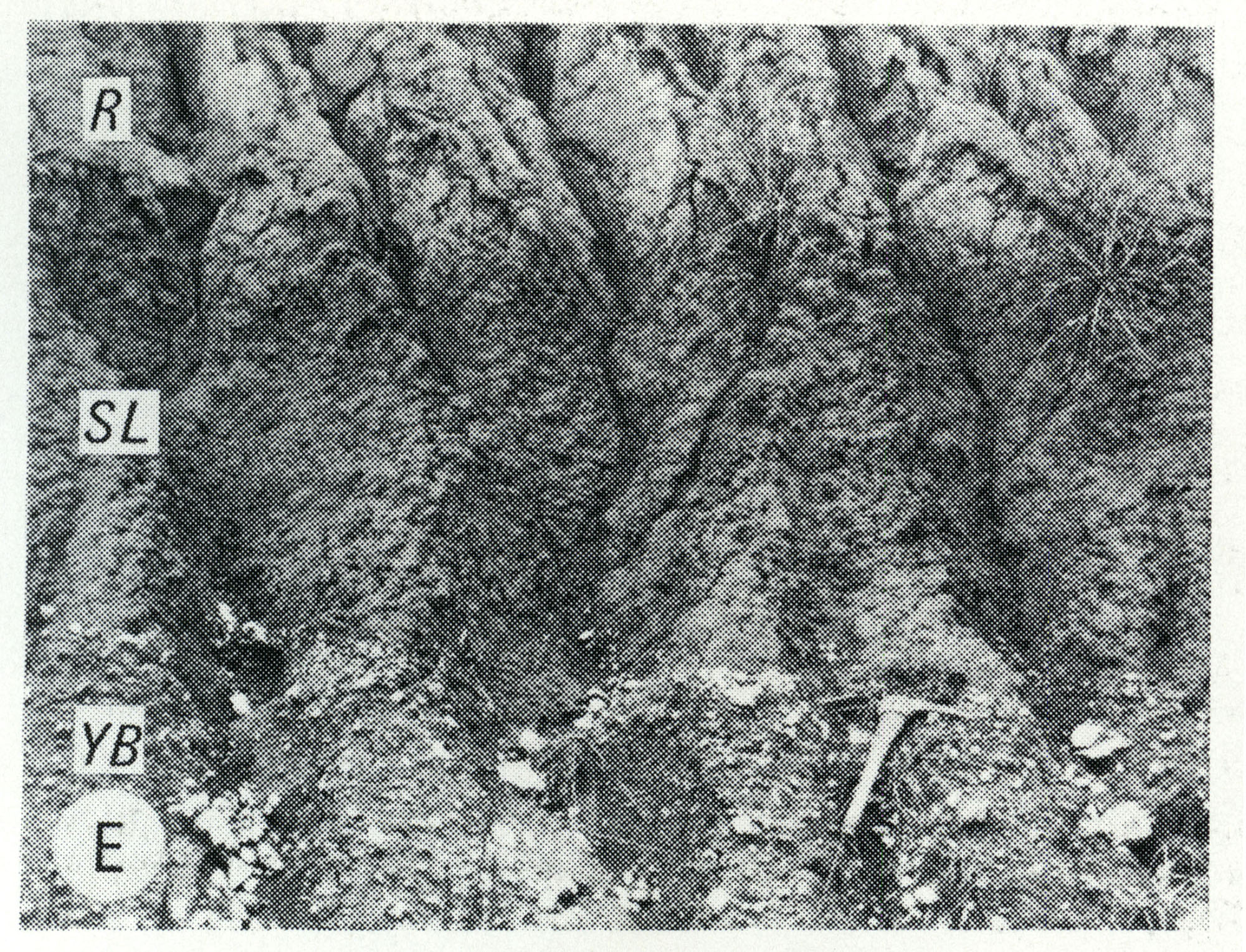
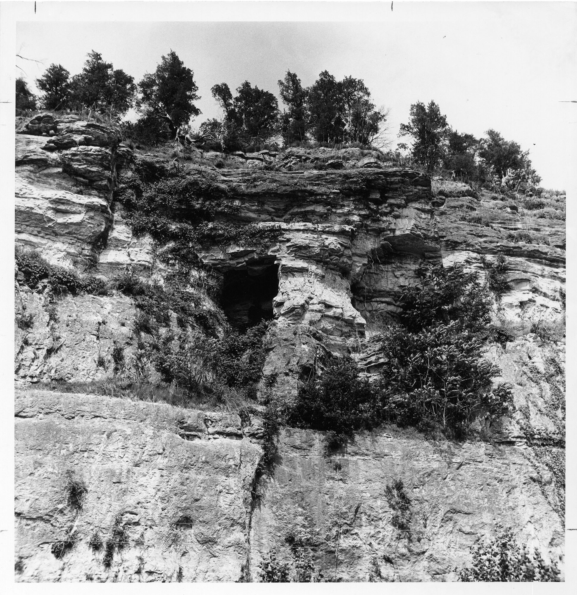
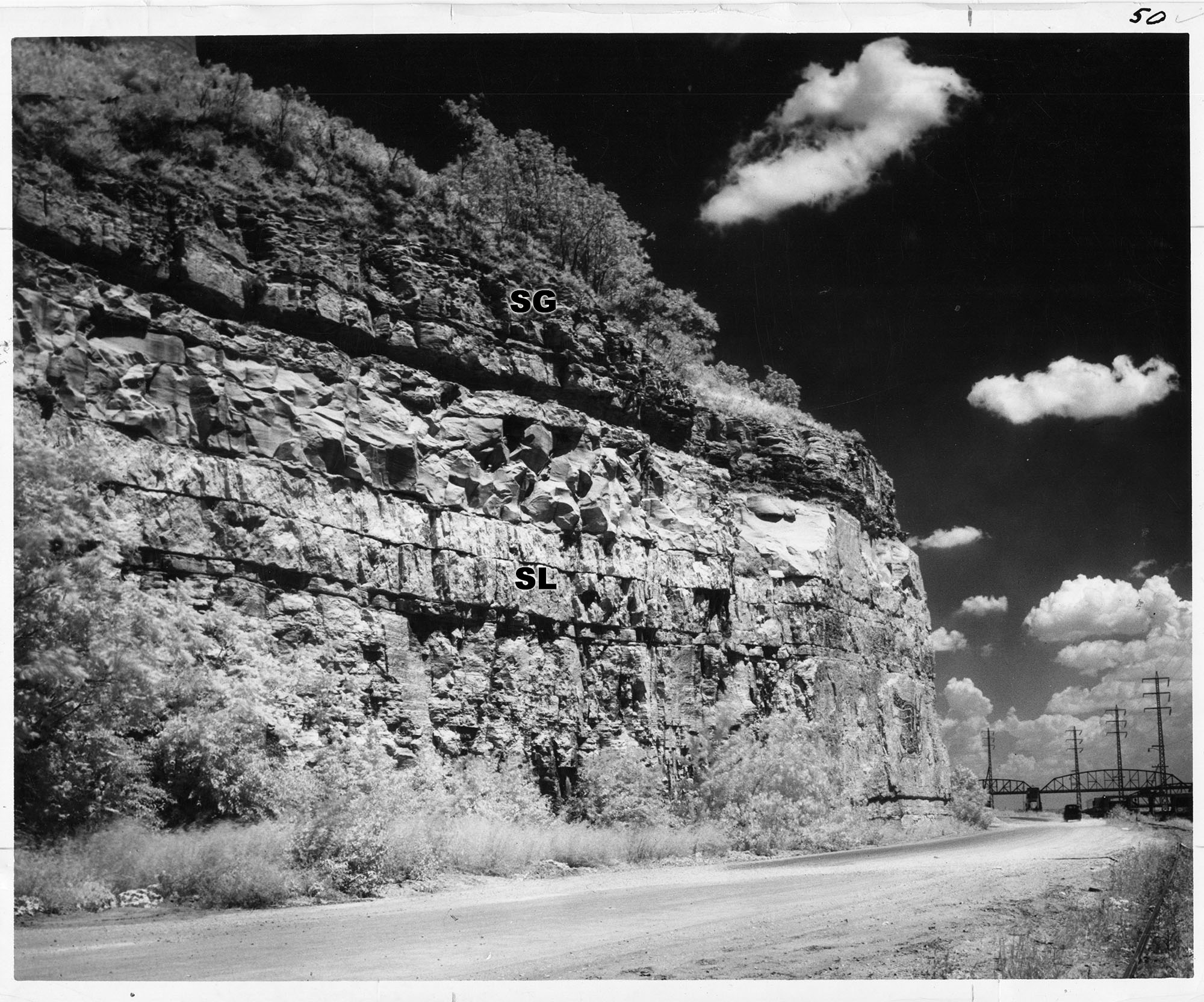
1.16 MB | Alan.Myers | Fig. Q-1E -- Wisconsinan Roxana Silt (R), Sangamon Soil developed in the Illinoian Loveland Silt (SL) and Yarmouth Soil developed in till of the Kansan Banner Formation (YB); in a roadcut at Independence, 5 miles south of Pittsfield, Pike County (Frye... | 1 |
| 13:10, 5 April 2016 | Figure Q-1D.jpg (file) |  |
1.16 MB | Alan.Myers | Fig. Q-1D -- Illinoian Glasford Formation (Hagarstown Member) showing steeply dipping sand and gravel (crevasse deposit) in a mound in the Kaskaskia Ridged Drift area, 2 miles southwest of Lakewood, Shelby County. | 1 |
| 20:22, 4 April 2016 | Figure O-2F.jpg (file) |  |
601 KB | Alan.Myers | Fig. O-2F -- Thin-bedded dolomite of the Quimbys Mill Formation overlying massive dolomite of the Nachusa Formation in a quarry on River Street in Dixon, Lee County. | 1 |
| 20:21, 4 April 2016 | Figure O-2E.jpg (file) |  |
585 KB | Alan.Myers | Fig. O-2E -- Massice Oneota Dolomite containing a large algal growth; in a quarry in Lee County, 6 Miles south of Rochelle, Ogle County. | 1 |
| 20:19, 4 April 2016 | Figure O-2D.jpg (file) |  |
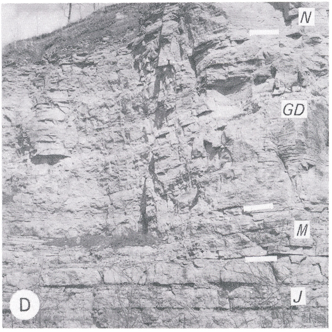
647 KB | Alan.Myers | Fig. O-2D -- Relatively thin-bedded Platteville Limestone Group showing the Nashusa (N), Grand Detour (GD), and Mifflin (M) Formations overlying the thick-bedded Joachim Dolomite (J) in a quarry at West Point Landing, Calhoun County (Templeton and Will... | 1 |
| 20:17, 4 April 2016 | Figure O-2C.jpg (file) |  |
669 KB | Alan.Myers | Fig. O-2C -- Massive Wise Lake Formation overlying the thinner bedded Dunleith Formation, which contains lenses and beds of white chert, in a quarry on the south side of Freeport, Stephenson County. | 1 |
| 20:14, 4 April 2016 | Figure O-2B.jpg (file) |  |
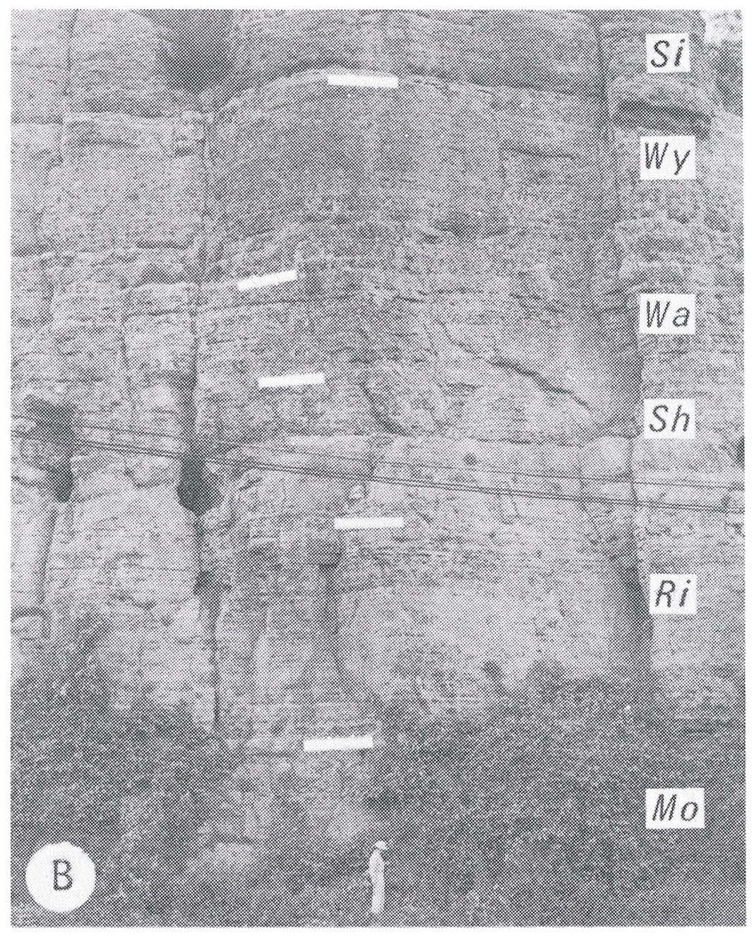
719 KB | Alan.Myers | Fig. O-2B -- Type section of Dunleith Formation showing the Mortime (Mo), Rivoli (Ri), Sherwood (Sh), Wall (Wa) and Wyota (Wy) Members overlain by the Sinsinawa Member (Si) of the Wise Lake Formation at East Dubuque, Jo Daviess County (Templeton and Wi... | 1 |
| 18:55, 4 April 2016 | Figure M-1F.jpg (file) |  |
1.03 MB | Alan.Myers | Fig. M-1F -- Grannular texture of the Ullin Limestone along Mill Creek, south of Anna, Union County (x1). | 1 |
| 18:54, 4 April 2016 | Figure M-1E.jpg (file) |  |
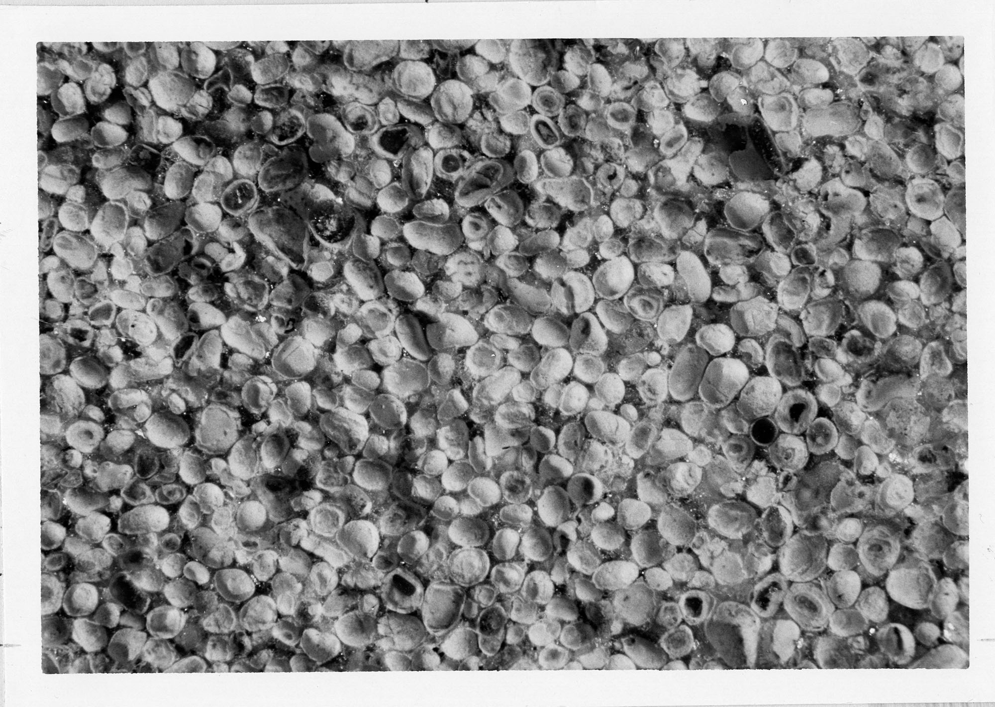
521 KB | Alan.Myers | Fig. M-1E -- Oolitic texture of the Ste. Genevieve Limestone at Anna, Union County (x10). | 1 |
| 18:52, 4 April 2016 | Figure M-1D.jpg (file) |  |
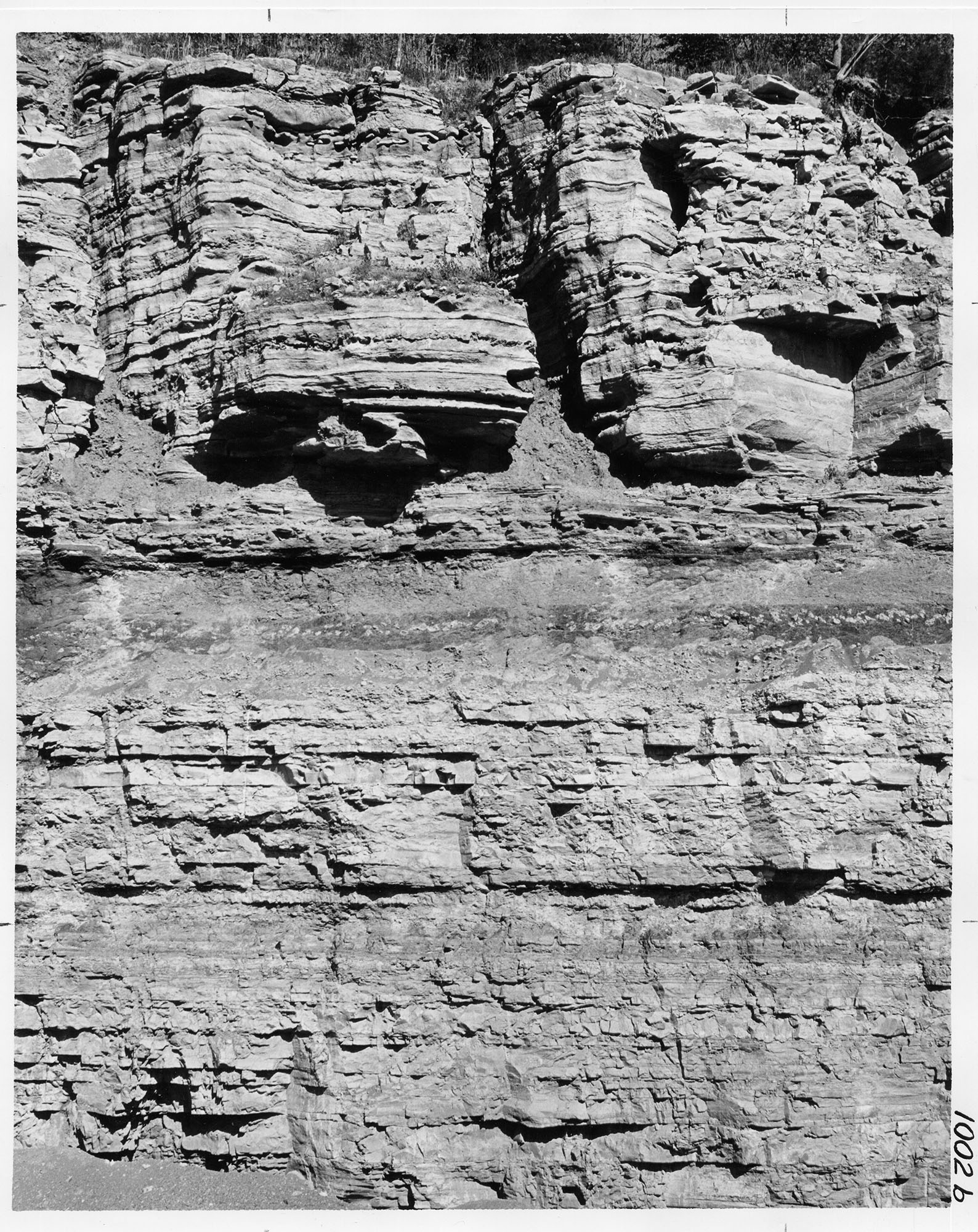
1.02 MB | Alan.Myers | Fig. M-1D -- Well bedded St. Louis Limestone with cave in its base overlying massive Salem Limestone in Mississippi River bluff a mile northwest of Prairie du Rocher, Randolph County. | 1 |
| 18:50, 4 April 2016 | Figure M-1C.jpg (file) |  |
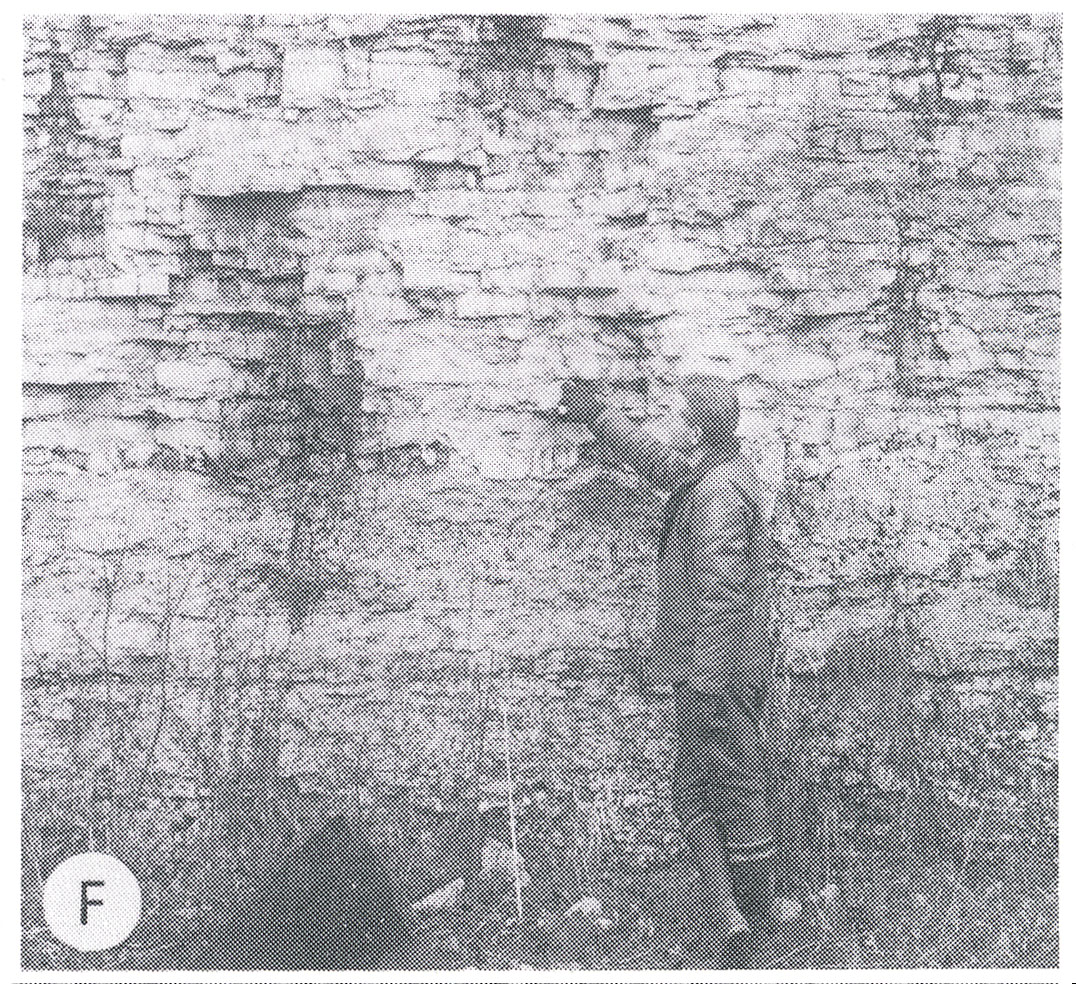
902 KB | Alan.Myers | Fig. M-1C -- Kinkaid Limestone showing clay-filled solution cavity in the Goreville Member at the top overlying a layer of shale with red bed (black) at the tope of the Cave Hill Member; in Southern Illinois Limestone Company quarry north of Buncombe,... | 1 |
| 18:46, 4 April 2016 | Figure M-1B.jpg (file) |  |
653 KB | Alan.Myers | Fig. M-1B -- Massive Ste. GEnevieve Limestone overlying well bedded St. Louis Limestone in Mississippi River bluff (about 60 feet high) on northwest side of Alton, Madison County. | 1 |