File list
Jump to navigation
Jump to search
This special page shows all uploaded files.
| Date | Name | Thumbnail | Size | User | Description | Versions |
|---|---|---|---|---|---|---|
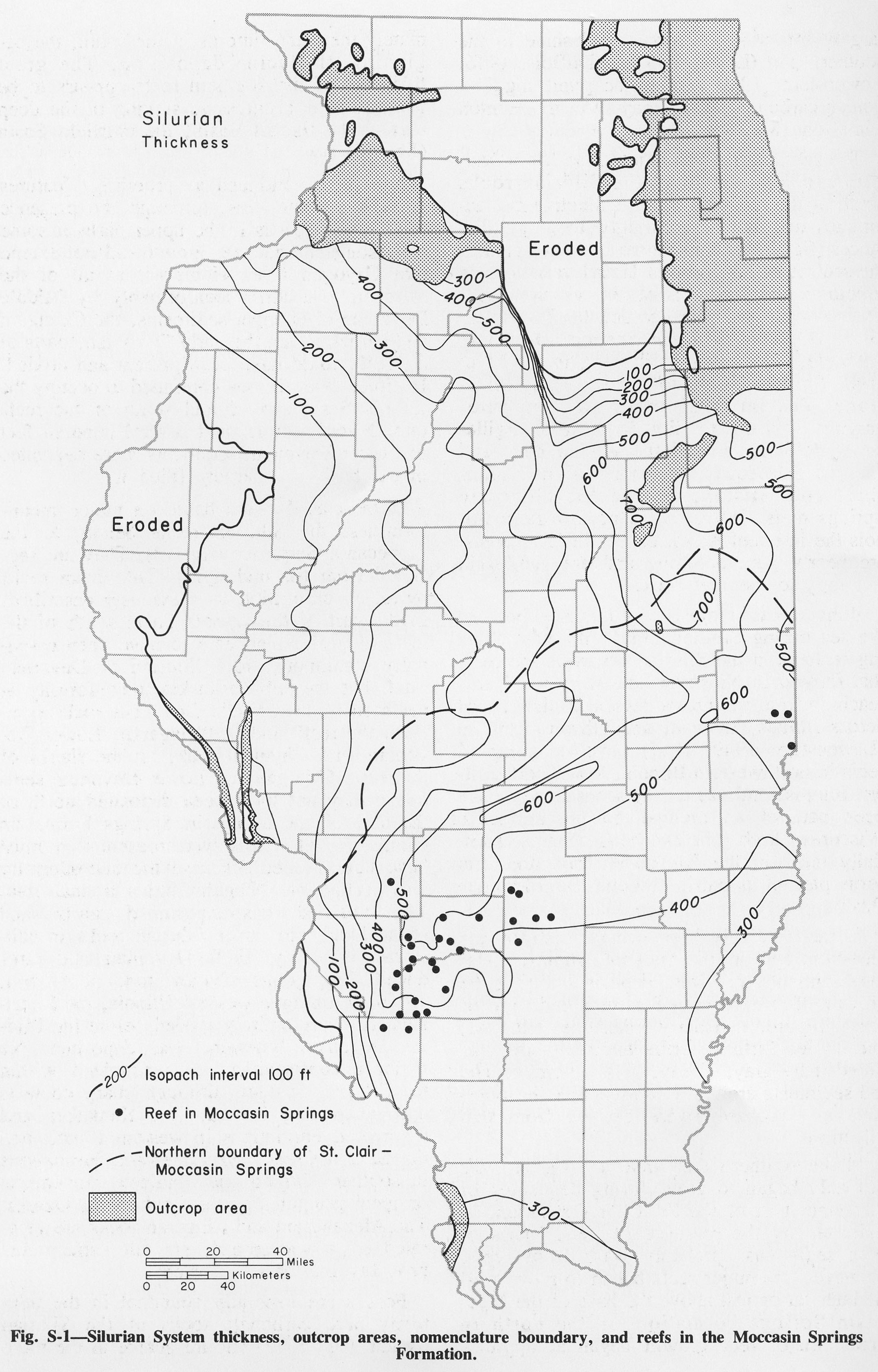
| 17:02, 4 April 2016 | Figure S-1.jpg (file) |  |
883 KB | Alan.Myers | Fig. S-1 -- Silurian System thickness, outcroup areas, nomenclature boundary, and reef in the Moccasin Springs Formation. | 1 |
| 17:56, 4 April 2016 | Figure S-10.jpg (file) |  |
326 KB | Alan.Myers | Fig. S-10 -- Development of the classification of the Silurian System in southern Illinois. | 1 |
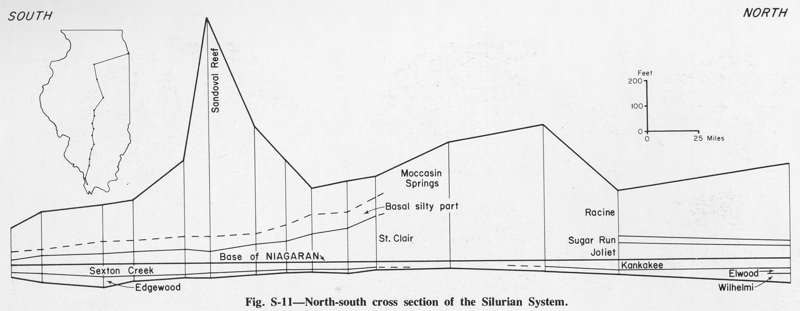
| 17:56, 4 April 2016 | Figure S-11.jpg (file) |  |
257 KB | Alan.Myers | Fig. S-11 -- North-south cross section of the Silurian System. | 1 |
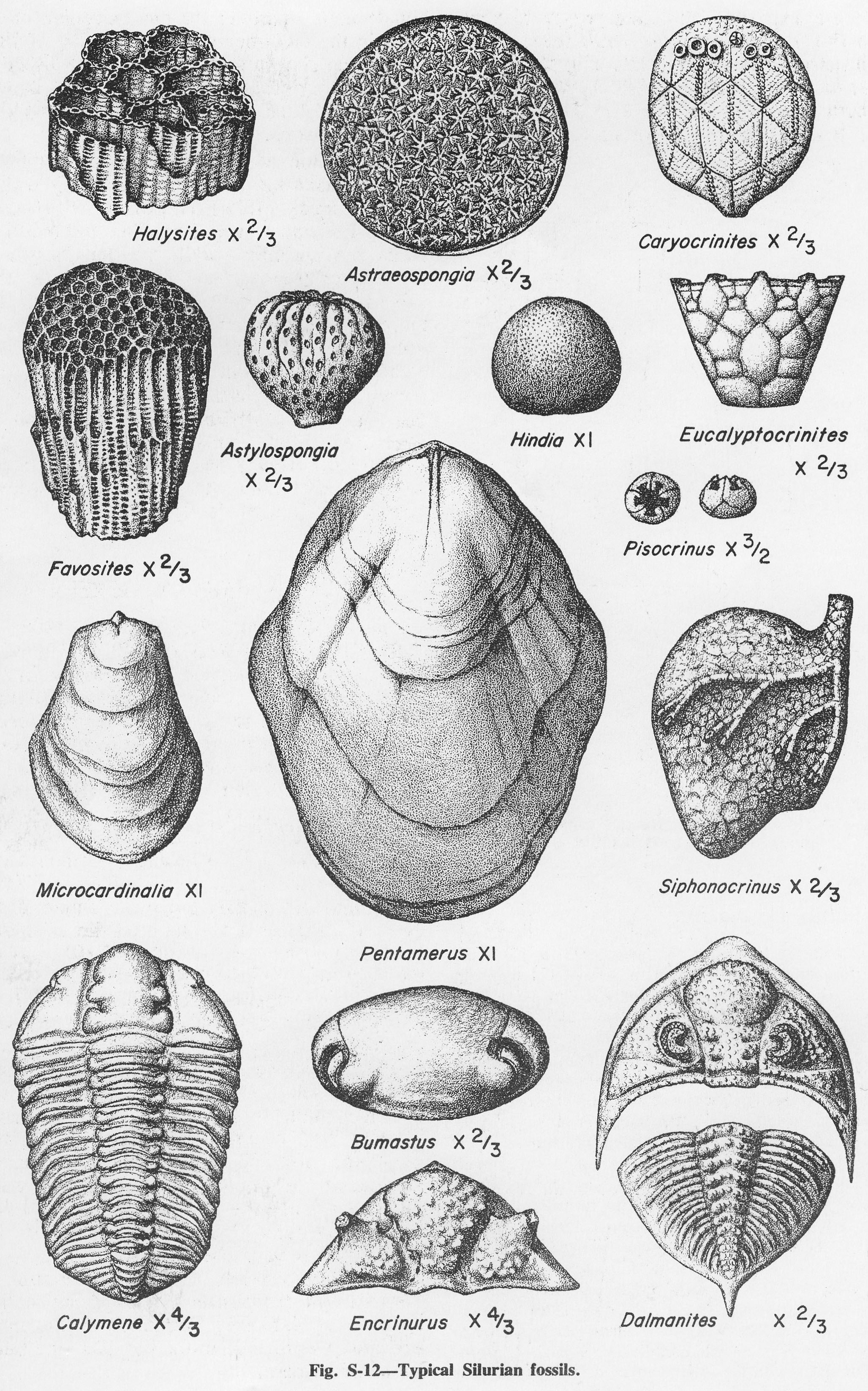
| 17:57, 4 April 2016 | Figure S-12.jpg (file) |  |
1.54 MB | Alan.Myers | Fig. S-12 -- Typical Silurian fossils. | 1 |
| 17:58, 4 April 2016 | Figure S-13.jpg (file) |  |
365 KB | Alan.Myers | Fig. S-13 -- Thickness of the Hunton Limestone Megagroup (modified from Bond et al., 1971). | 1 |
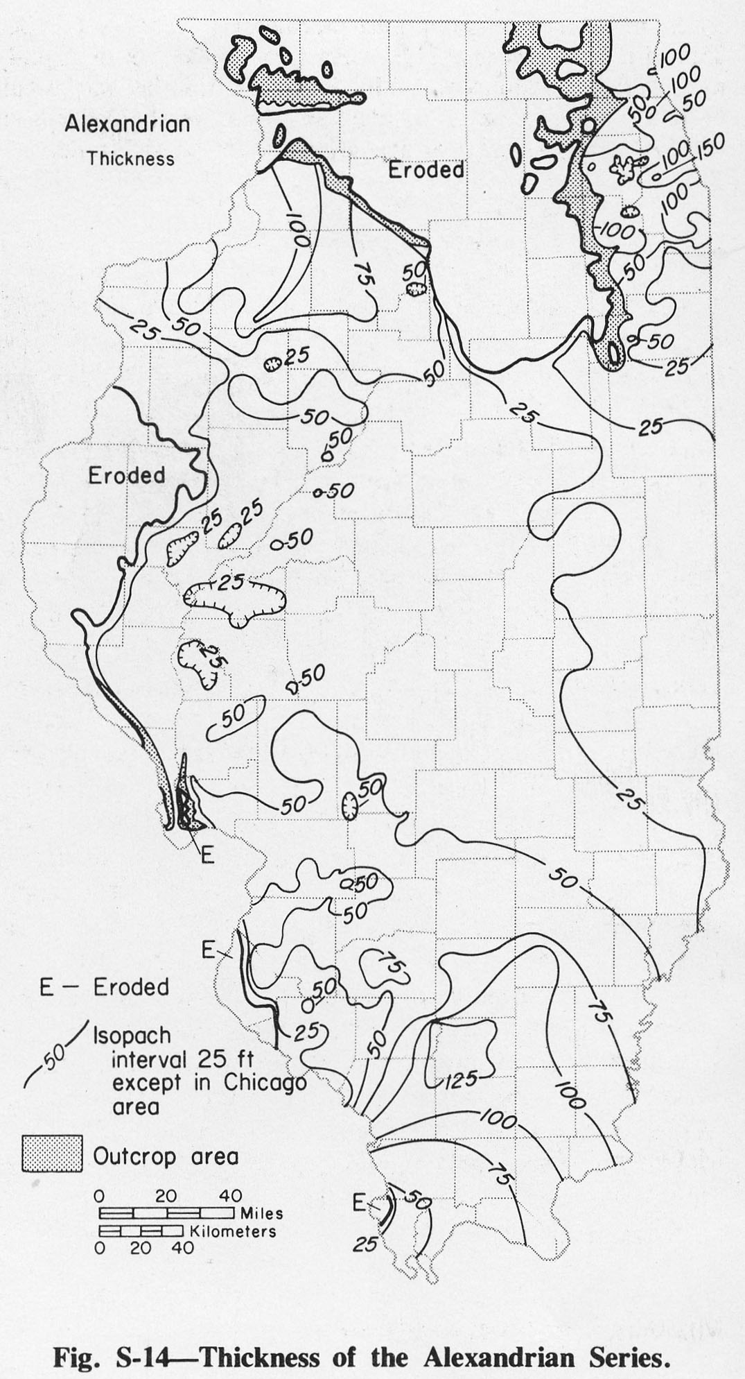
| 17:59, 4 April 2016 | Figure S-14.jpg (file) |  |
328 KB | Alan.Myers | Fig. S-14 -- Thickness of the Alexandrian Series. | 1 |
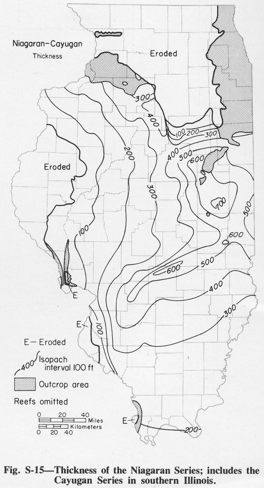
| 18:00, 4 April 2016 | Figure S-15.jpg (file) |  |
322 KB | Alan.Myers | Fig. S-15 -- Thickness of teh Niagaran Series; includes the Cayugan Series in southern Illinois. | 1 |
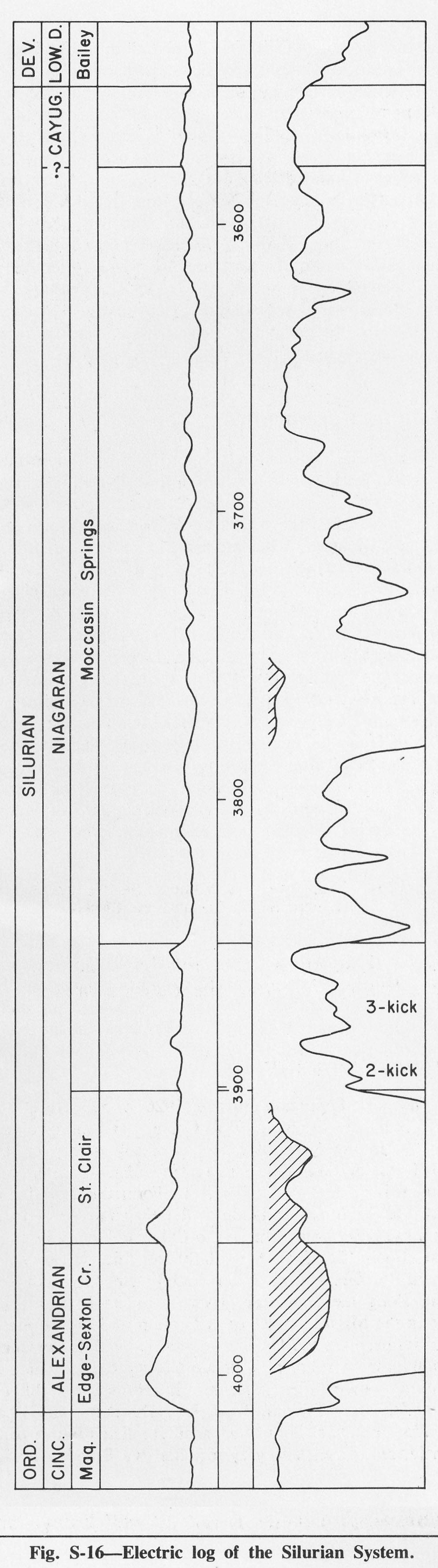
| 18:02, 4 April 2016 | Figure S-16.jpg (file) |  |
323 KB | Alan.Myers | Fig. S-16 -- Electric log of the Silurian System. | 1 |
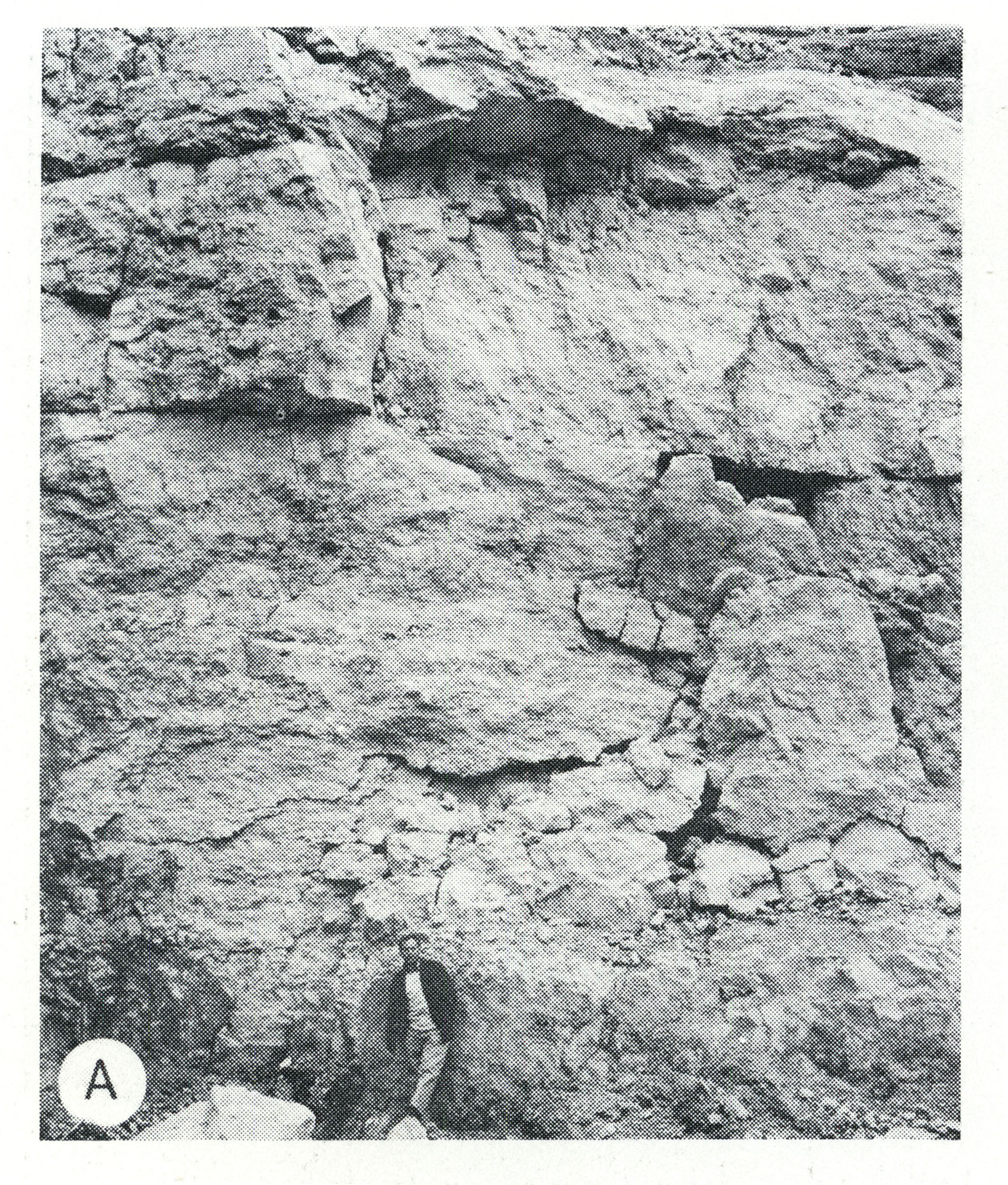
| 13:14, 5 April 2016 | Figure S-2A.jpg (file) |  |
1.33 MB | Alan.Myers | Fig. S-2A -- Massive dolomite in the core of a Racine (Niagaran) reef, at the top of the Material Service Corporation (Stearns) quarry on Archer Avenue at 28th Street, Chicago. | 1 |
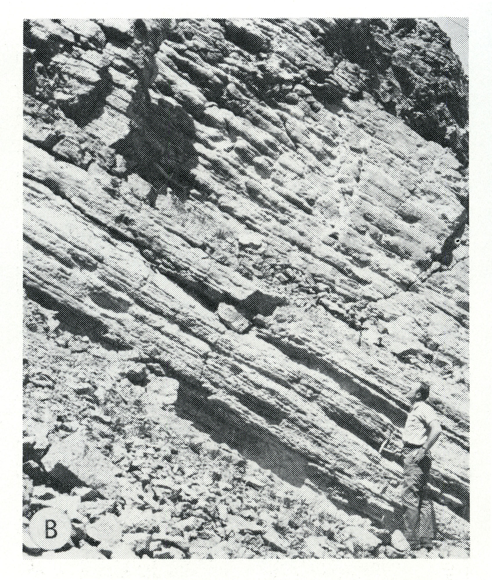
| 13:14, 5 April 2016 | Figure S-2B.jpg (file) |  |
1.29 MB | Alan.Myers | Fig. S-2B -- Steeply dipping, well bedded dolomite forming the fiank of a Racine (Niagaran) reef, in the Material Service Corporation quarry at Thornton, Cook County. | 1 |
| 13:15, 5 April 2016 | Figure S-2C.jpg (file) |  |
1.38 MB | Alan.Myers | Fig. S-2C -- Massive Marcus Dolomite in a quarry 3 miles east of Fulton, Whiteside County. | 1 |
| 13:16, 5 April 2016 | Figure S-2D.jpg (file) |  |
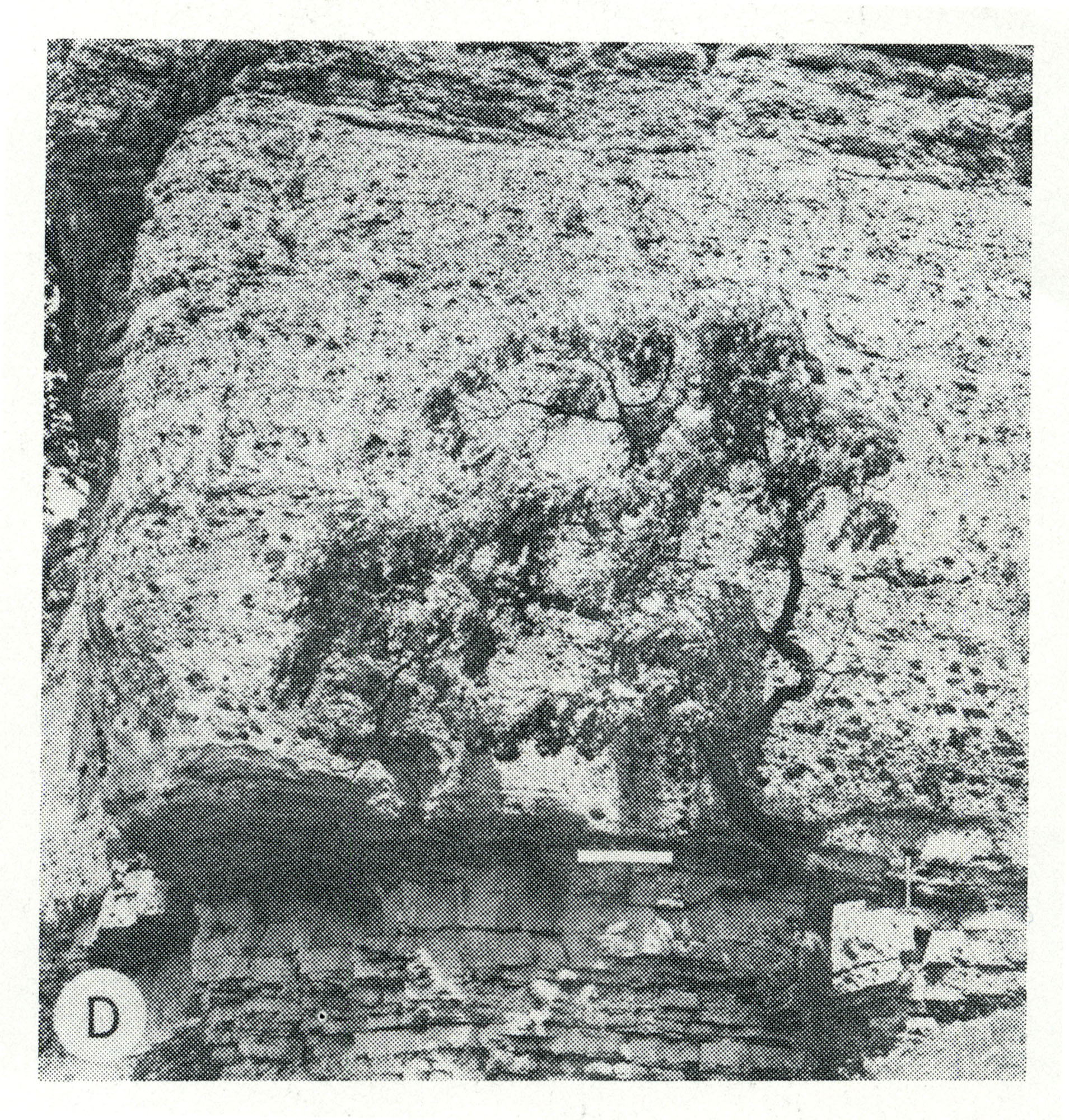
1.46 MB | Alan.Myers | Fig. S-2D -- Massive Tete des Morts Formation overlying the Mosalem Formation at the top of Silurian escarpment, 4 miles southeast of Galena, Jo Daviess County. | 1 |
| 13:16, 5 April 2016 | Figure S-2E.jpg (file) |  |
1.26 MB | Alan.Myers | Fig. S-2E -- Mottled, porous, pure dolomite characteristic of Racine reef facies in the Chicago area (x 1). | 1 |
| 13:22, 5 April 2016 | Figure S-2F.jpg (file) |  |
1.19 MB | Alan.Myers | Fig. S-2F -- Dense, argillaceous dolomite containing chert nodules characteristic of Racine interreef facies in the Chicago area. The outer, porous parts of the nodules are blackened by air pollutants. | 1 |
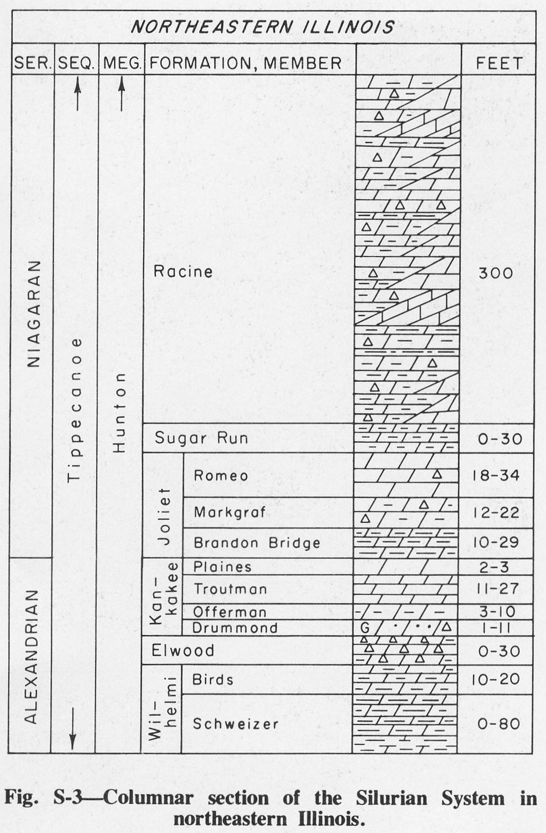
| 17:03, 4 April 2016 | Figure S-3.jpg (file) |  |
254 KB | Alan.Myers | Fig. S-3 -- Columnar section of Silurian System in northeastern Illinois. | 1 |
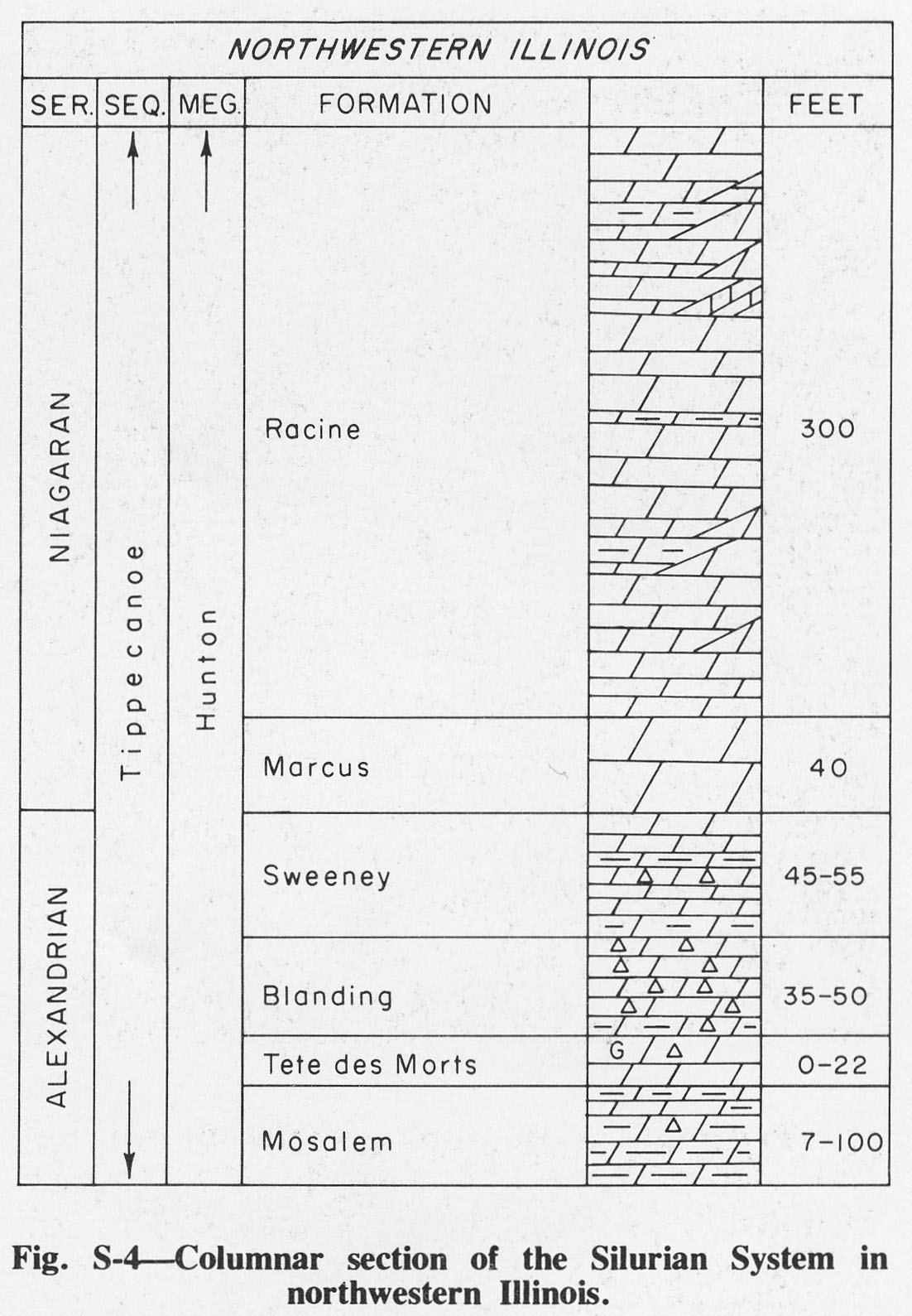
| 17:03, 4 April 2016 | Figure S-4.jpg (file) |  |
219 KB | Alan.Myers | Fig. S-4 -- Columnar section of the Silurian System in northwestern Illinois. | 1 |
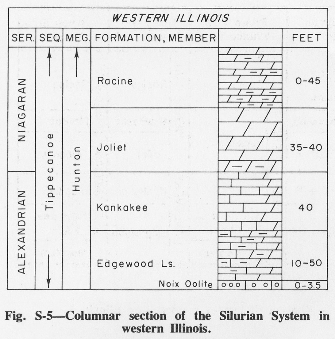
| 17:11, 4 April 2016 | Figure S-5.jpg (file) |  |
198 KB | Alan.Myers | Fig. S-5 -- Columnar section of the Silurian System in western Illinois. | 1 |
| 17:52, 4 April 2016 | Figure S-6.jpg (file) |  |
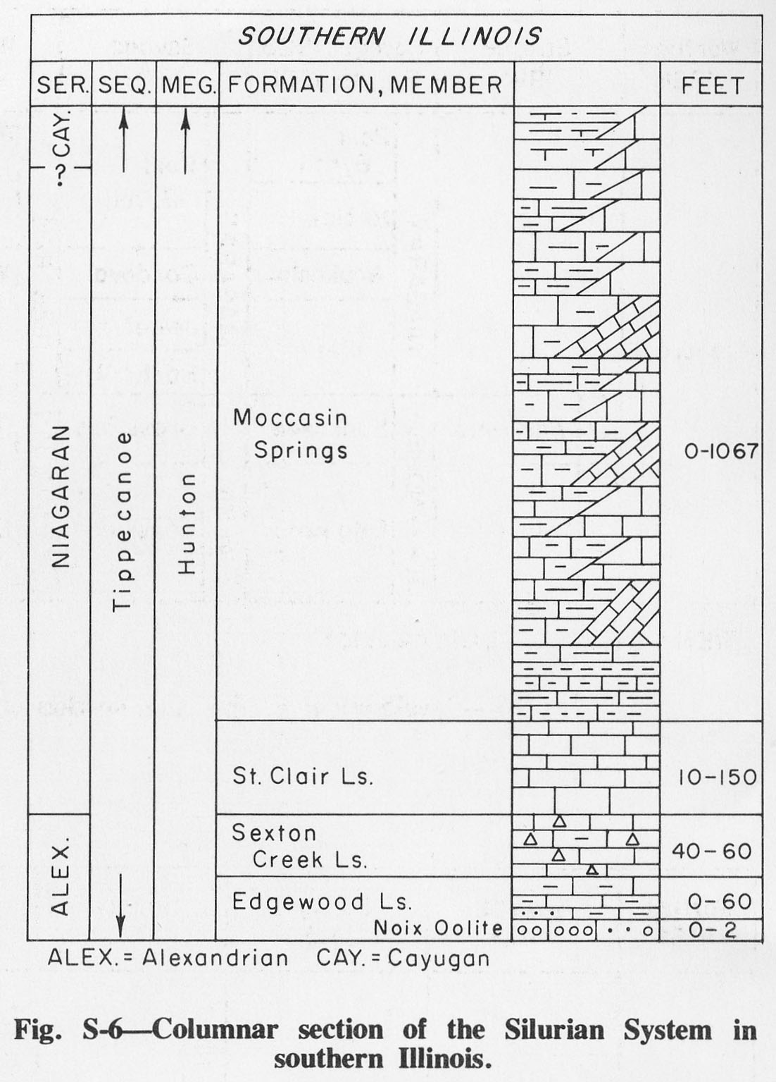
209 KB | Alan.Myers | Fig. S-6 -- Columnar section of Silurian System in southern Illinois. | 1 |
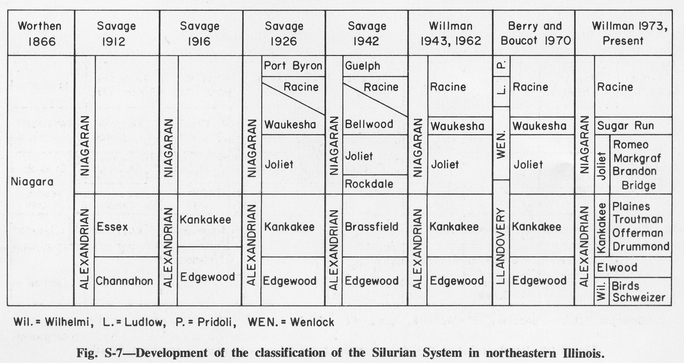
| 17:53, 4 April 2016 | Figure S-7.jpg (file) |  |
329 KB | Alan.Myers | Fig. S-7 -- Development of the classification of the Silurian System in northeastern Illinois. | 1 |
| 17:54, 4 April 2016 | Figure S-8.jpg (file) |  |
319 KB | Alan.Myers | Fig. S-8 -- Development of the classification of the Silurian System in northwestern Illinois. | 1 |
| 17:55, 4 April 2016 | Figure S-9.jpg (file) |  |
269 KB | Alan.Myers | Fig. S-9 -- Development of the classification of the Silurian System in western Illinois. | 1 |
| 18:04, 4 April 2016 | Figure T-1.jpg (file) |  |
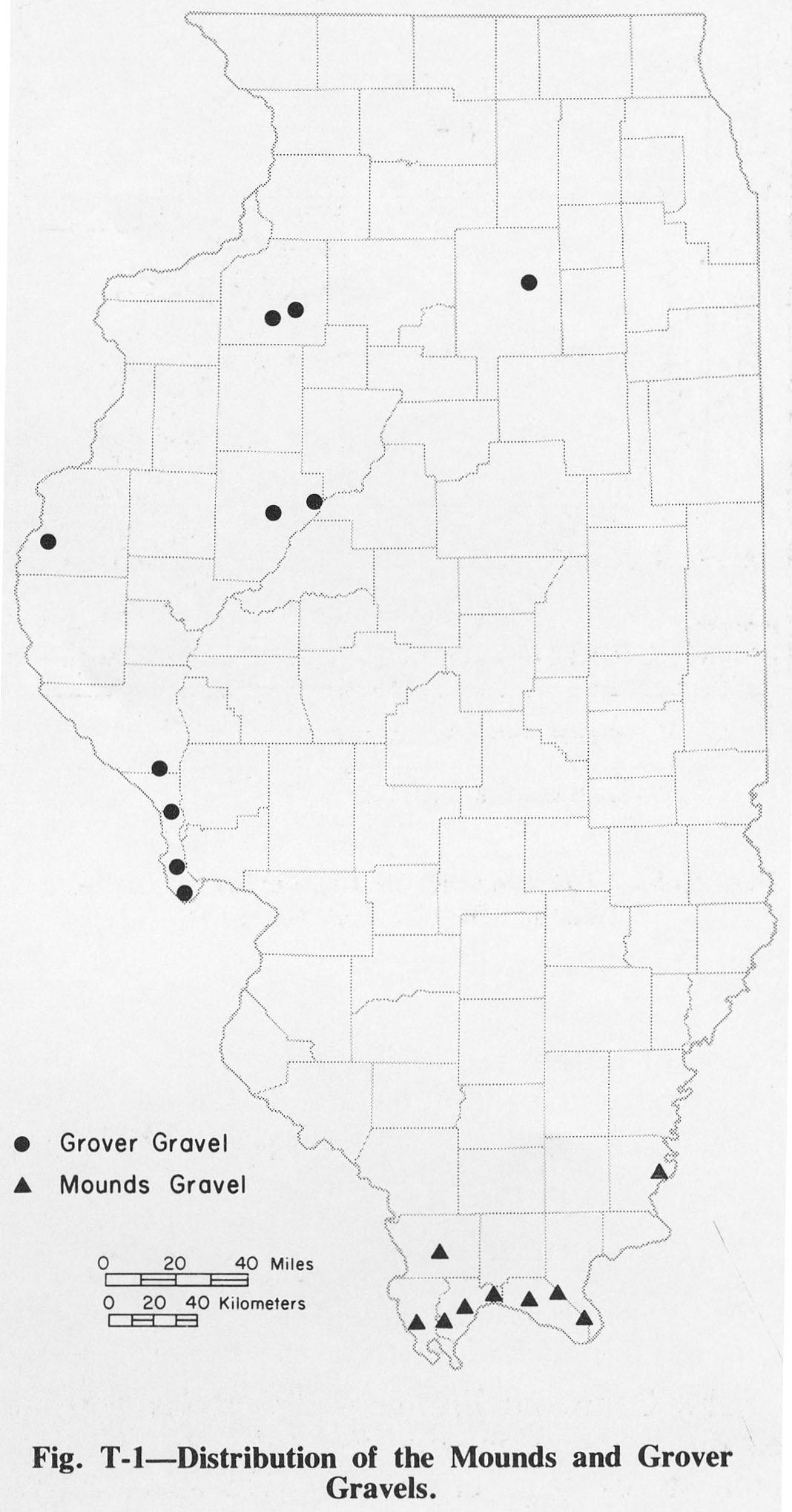
209 KB | Alan.Myers | Fig. T-1 -- Distribution of the Mounds and Grover Gravels. | 1 |
| 18:05, 4 April 2016 | Figure T-2.jpg (file) |  |
233 KB | Alan.Myers | Fig. T-2 -- Classification of the Tertiary System. | 1 |
| 13:32, 16 October 2019 | GOI-ch15-fig15.jpg (file) |  |
1.88 MB | Alan.Myers | 1 | |
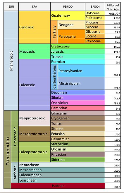
| 17:54, 10 August 2015 | Geologic-time-scale1.jpg (file) |  |
67 KB | Alan.Myers | 1 | |
| 17:09, 3 February 2017 | Howto edit move page.jpg (file) |  |
15 KB | Jennifer.Obrad | 2 | |
| 15:49, 13 December 2016 | Howto edit move page code.jpg (file) |  |
15 KB | Alan.Myers | How to edit move page code | 1 |
| 15:43, 13 December 2016 | Howto edit move page settings.jpg (file) |  |
32 KB | Alan.Myers | How to edit move page settings | 1 |
| 19:56, 13 December 2016 | Howto edit sections.JPG (file) |  |
90 KB | Alan.Myers | 1 | |
| 17:01, 3 February 2017 | Howto edit tab.JPG (file) | 11 KB | Jennifer.Obrad | 2 | ||
| 16:55, 13 December 2016 | Howto start of form.jpg (file) |  |
99 KB | Alan.Myers | Howto start of form | 1 |
| 20:09, 5 August 2015 | ISGS logo.jpg (file) | 178 KB | Alan.Myers | 1 | ||
| 13:42, 2 December 2016 | Imagemap 1.JPG (file) |  |
62 KB | Alan.Myers | image for image map howto | 1 |
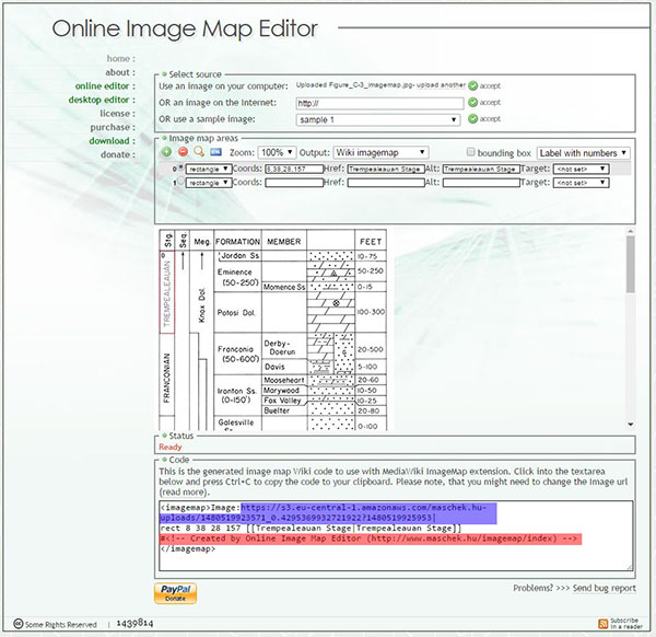
| 13:44, 2 December 2016 | Imagemap 2.JPG (file) |  |
103 KB | Alan.Myers | image for imagemap howto | 1 |
| 17:30, 14 July 2020 | Left-Arrow.png (file) | 6 KB | Alan.Myers | 1 | ||
| 18:39, 29 September 2020 | Logo.gif (file) | 743 bytes | Alan.Myers | 1 | ||
| 19:28, 20 September 2017 | Mainpagetime.jpg (file) |  |
97 KB | Alan.Myers | 2 | |
| 16:48, 4 January 2017 | Mesozoic search.jpg (file) |  |
27 KB | Alan.Myers | for the imagepage on the Mesozoic search page | 1 |
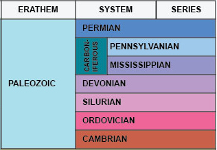
| 19:32, 29 December 2016 | Paleozoic imagemap.jpg (file) |  |
63 KB | Alan.Myers | 1 | |
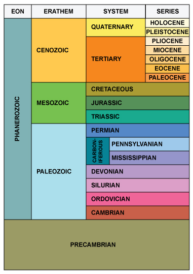
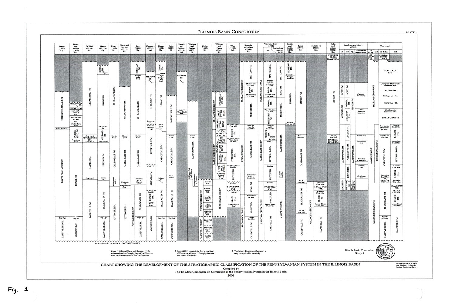
| 16:57, 8 March 2016 | Penn carb fig1.jpg (file) |  |
276 KB | Jennifer.Obrad | Chart Showing the Development of the Stratigraphic Classification of the Pennsylvanian System in the Illinois Basin. Compiled by the Tri-State Committee on Correlation of the Pennsylvanian System in the Illinois Basion, 2001. | 1 |
| 23:20, 8 March 2016 | Penn carb fig2.jpg (file) |  |
1.26 MB | Jennifer.Obrad | 1 | |
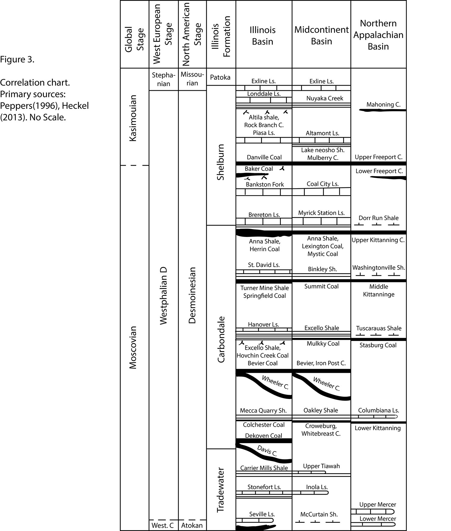
| 17:06, 8 March 2016 | Penn carb fig3.jpg (file) |  |
905 KB | Jennifer.Obrad | Correlation chart. Primary sources: Peppers (1996), Hickel (2013). No Scale | 1 |
| 19:07, 8 March 2016 | Penn carb fig63.jpg (file) |  |
665 KB | Jennifer.Obrad | Graphic Log of part of continuous core from Madison Coal Corp. borehole #25 in Williamson County. Reference section for Herrin Coal. | 1 |
| 19:14, 8 March 2016 | Penn carb fig64.jpg (file) |  |
1.39 MB | Jennifer.Obrad | Photograph of hand speciman of "Blue band" | 1 |
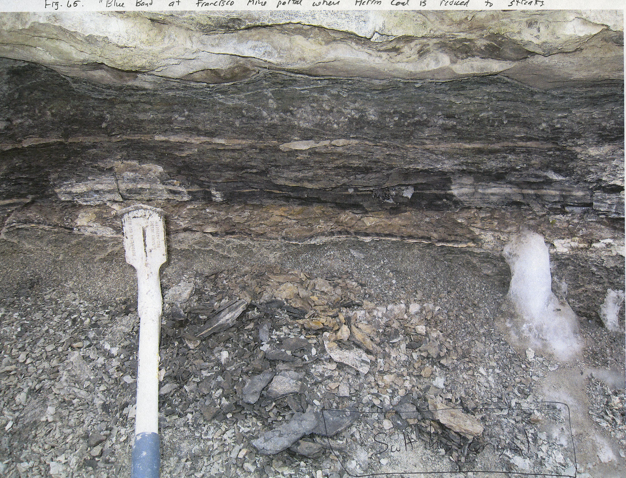
| 19:15, 8 March 2016 | Penn carb fig65.jpg (file) |  |
1.22 MB | Jennifer.Obrad | "Blue band" at Francisco Mine portal where Herrin Coal is reduced to streaks | 1 |
| 20:39, 22 December 2020 | Penn carbondale 4-1.jpg (file) |  |
1.23 MB | Jennifer.Obrad | 1 | |
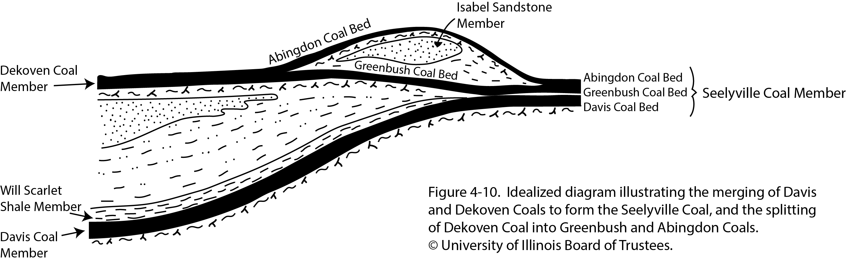
| 21:04, 26 January 2021 | Penn carbondale 4-10.jpg (file) |  |
493 KB | Jennifer.Obrad | 1 | |
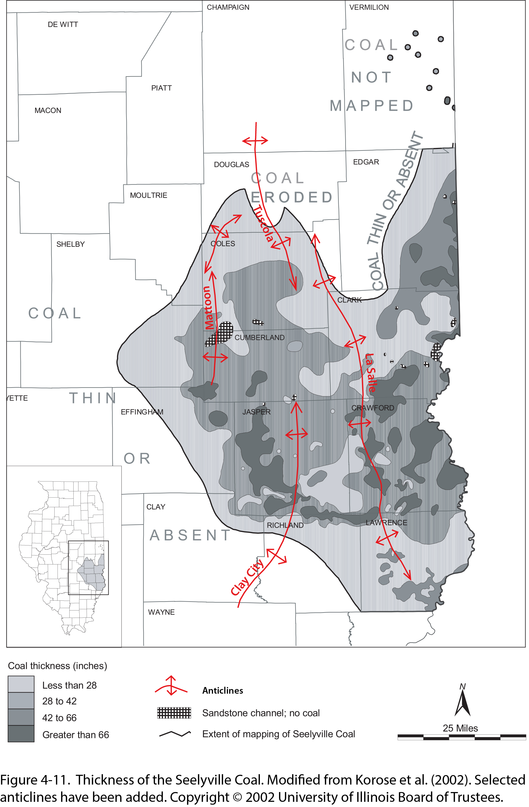
| 21:05, 26 January 2021 | Penn carbondale 4-11.jpg (file) |  |
1.13 MB | Jennifer.Obrad | 1 | |
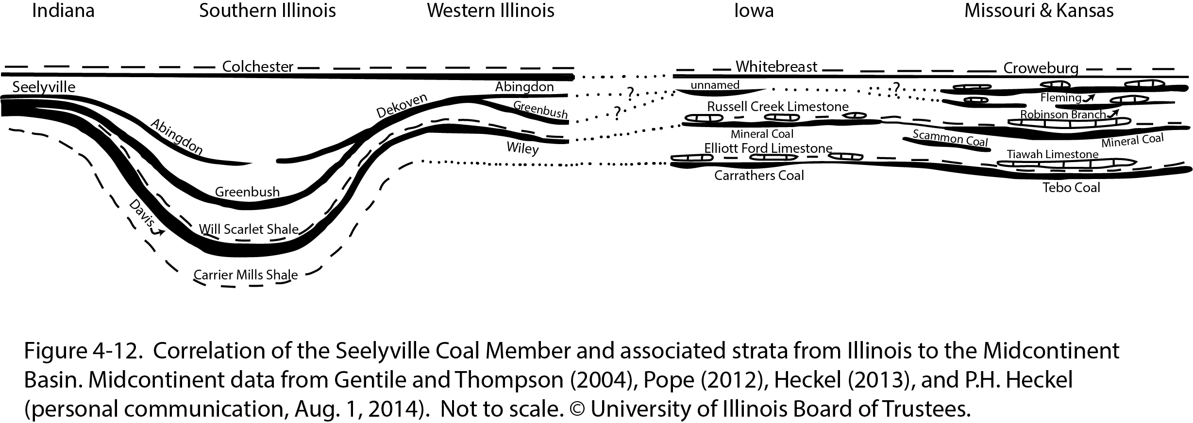
| 21:06, 26 January 2021 | Penn carbondale 4-12.jpg (file) |  |
490 KB | Jennifer.Obrad | 1 | |
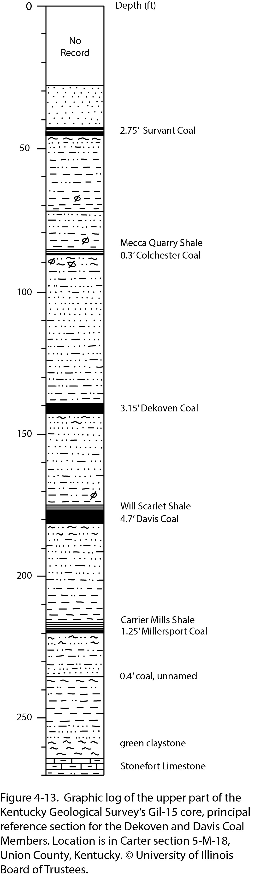
| 21:07, 26 January 2021 | Penn carbondale 4-13.jpg (file) |  |
466 KB | Jennifer.Obrad | 1 |