File list
Jump to navigation
Jump to search
This special page shows all uploaded files.
| Date | Name | Thumbnail | Size | User | Description | Versions |
|---|---|---|---|---|---|---|
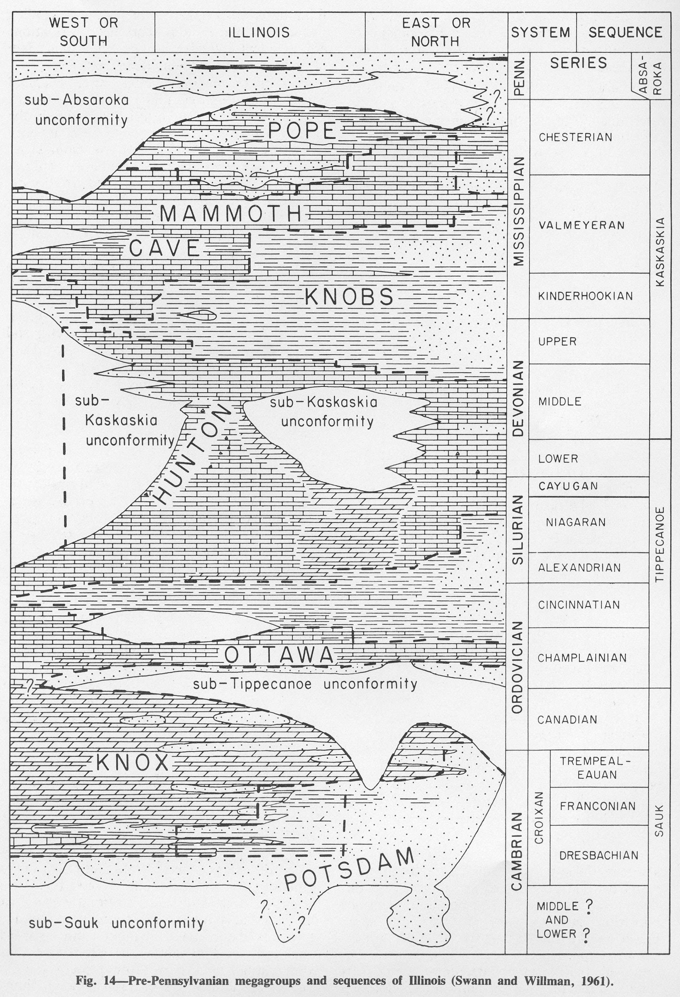
| 19:36, 1 April 2016 | Figure 14.jpg (file) |  |
1.08 MB | Alan.Myers | Fig. 14 -- Pre-Pennsylvanian megagroups and sequences of Illinois (Swann and Willman, 1961). | 1 |
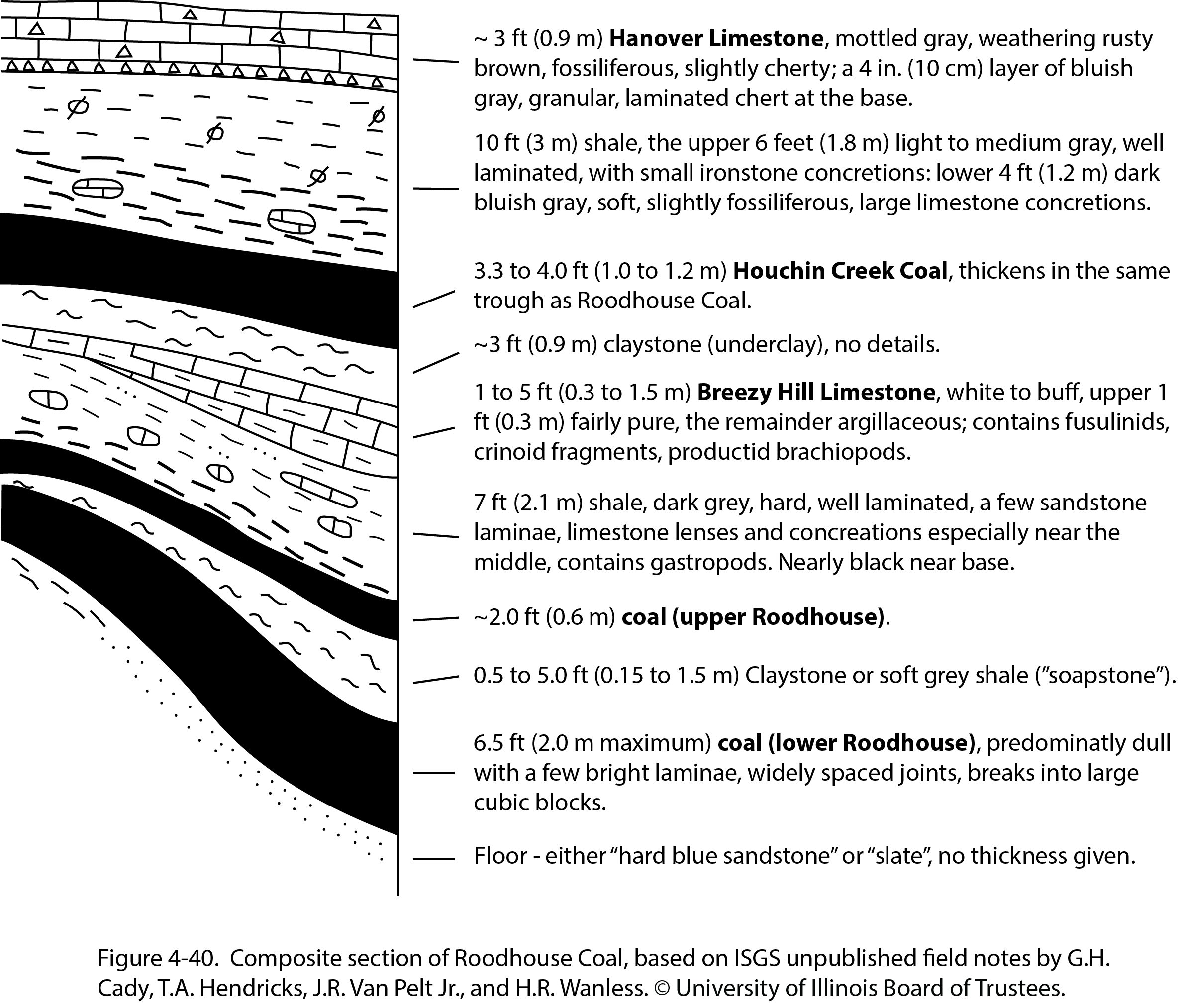
| 17:41, 23 December 2020 | Penn carbondale 4-40.jpg (file) |  |
1.08 MB | Jennifer.Obrad | 1 | |
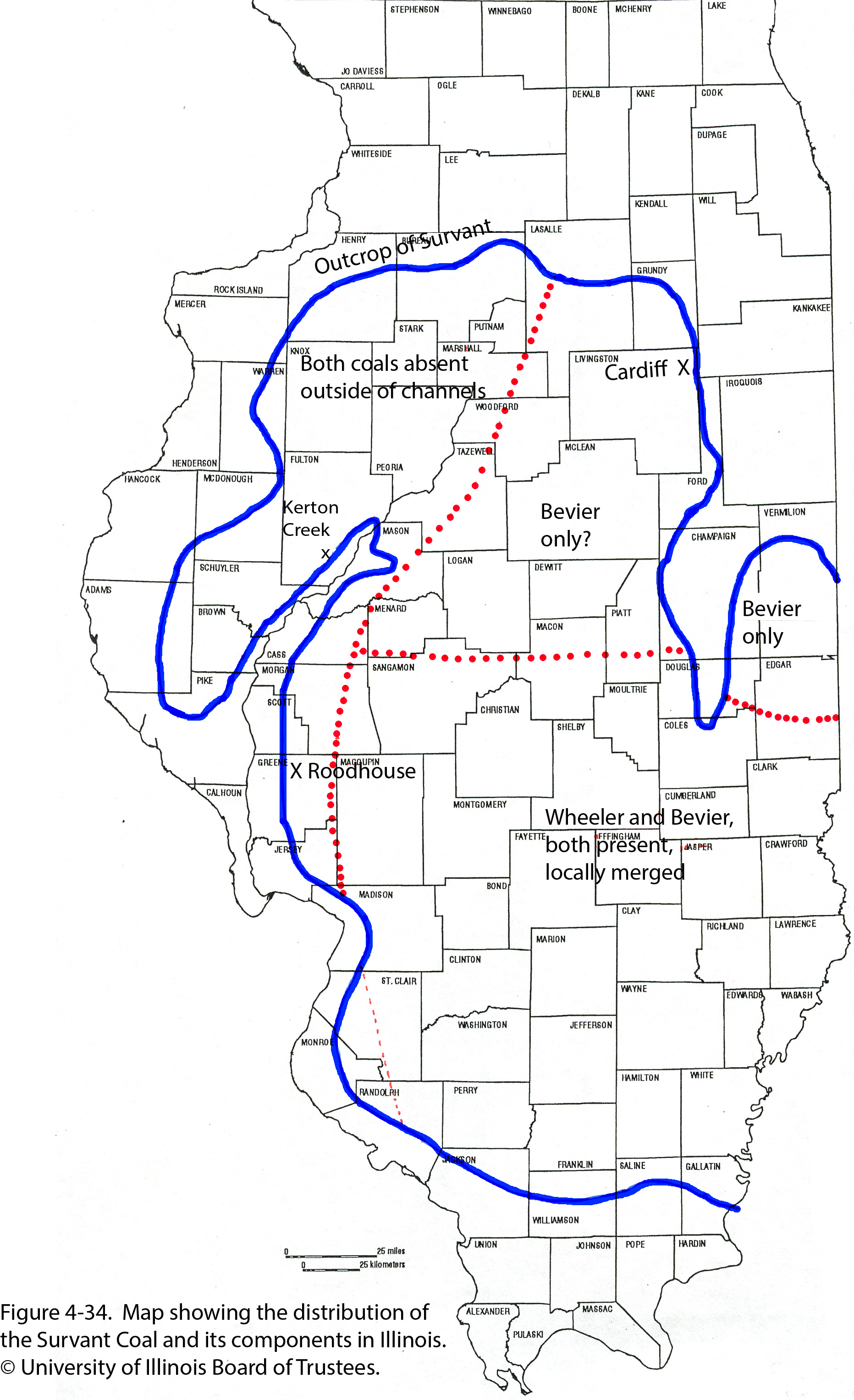
| 17:27, 23 December 2020 | Penn carbondale 4-34.jpg (file) |  |
1.09 MB | Jennifer.Obrad | 1 | |
| 14:53, 9 July 2020 | C605-Figure-15.jpg (file) |  |
1.09 MB | Alan.Myers | 1 | |
| 15:39, 11 July 2020 | C605-Figure-46.jpg (file) |  |
1.09 MB | Alan.Myers | 1 | |
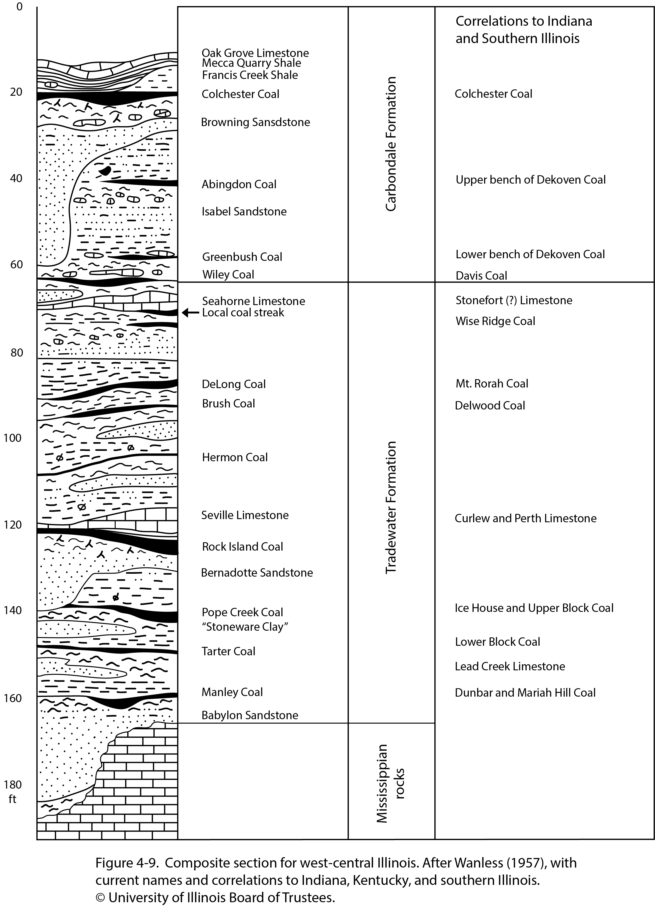
| 21:03, 26 January 2021 | Penn carbondale 4-9.jpg (file) |  |
1.1 MB | Jennifer.Obrad | 1 | |
| 16:12, 5 April 2016 | Figure Q-1B.jpg (file) |  |
1.11 MB | Alan.Myers | Fig. Q-1B -- The Wisconsinan Wedron (W-interbedded till and outwash) and Peddicord (P-lake sediments) Formations overlying till of the Illinoian Glasford Formation in the Wedron Silica Company pit at Wedron, LaSalle County-the type sections of the Wedr... | 2 |
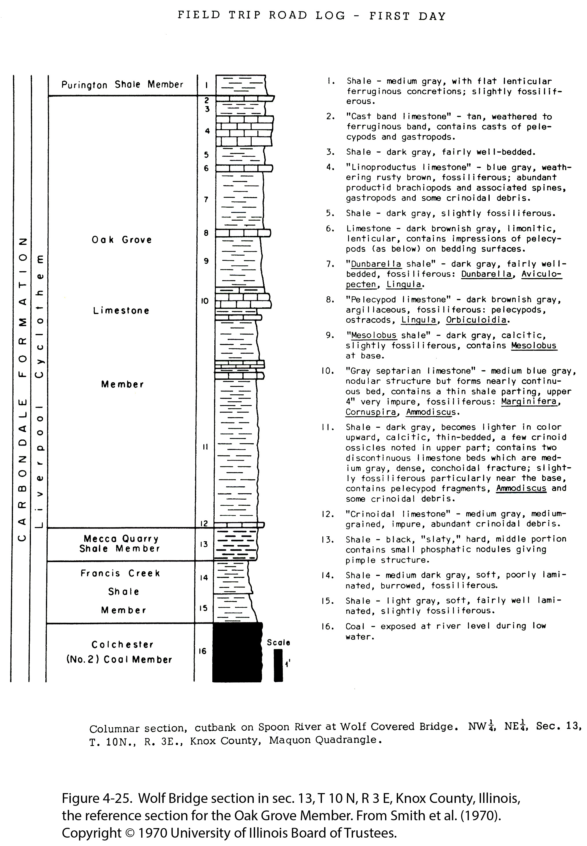
| 16:31, 23 December 2020 | Penn carbondale 4-25.jpg (file) |  |
1.12 MB | Jennifer.Obrad | 1 | |
| 16:12, 10 August 2015 | Pennsylvanian column.jpg (file) |  |
1.13 MB | Alan.Myers | Pennsylvanian Column test | 1 |
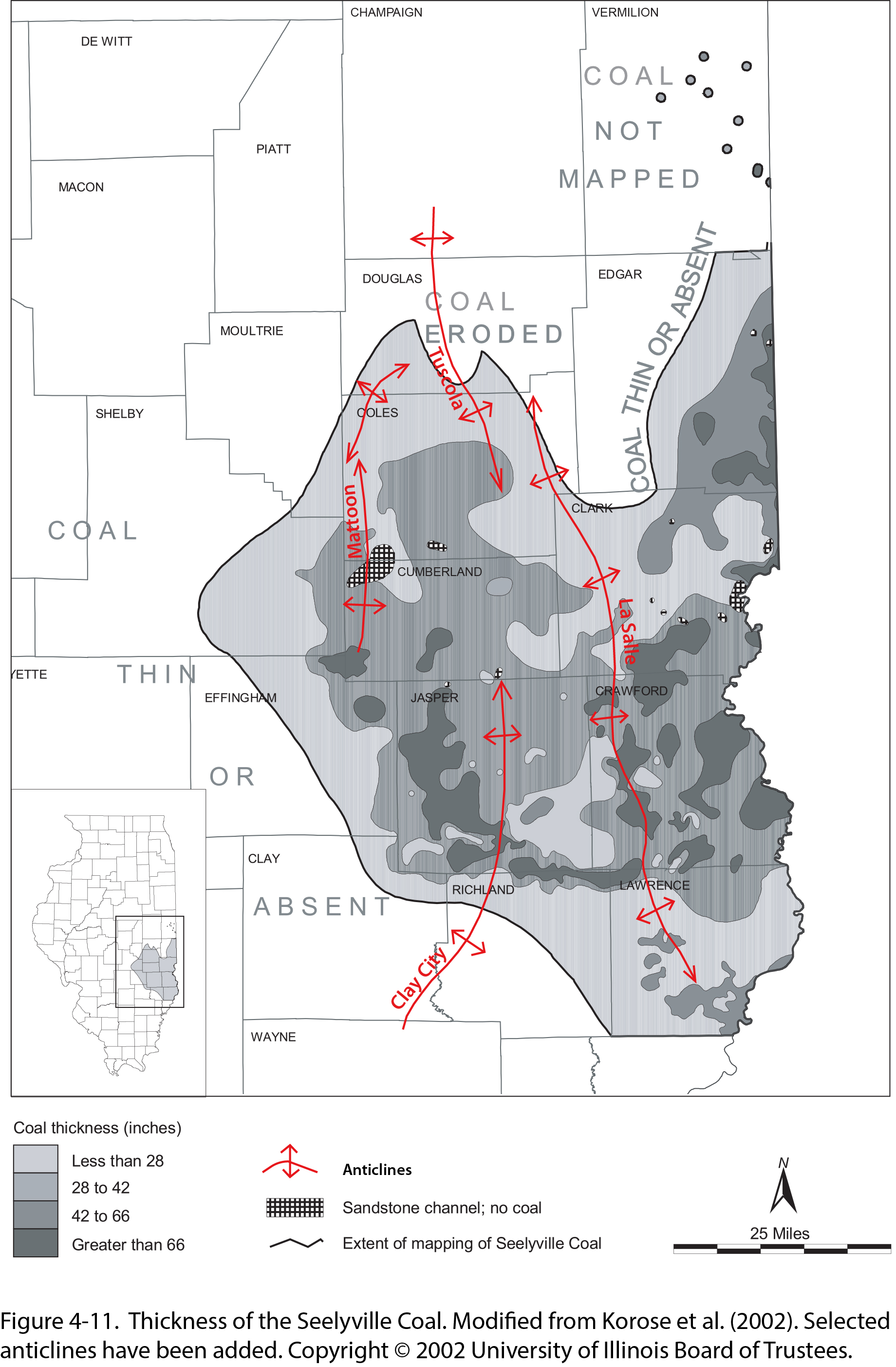
| 21:05, 26 January 2021 | Penn carbondale 4-11.jpg (file) |  |
1.13 MB | Jennifer.Obrad | 1 | |
| 13:12, 5 April 2016 | Figure Q-1F.jpg (file) |  |
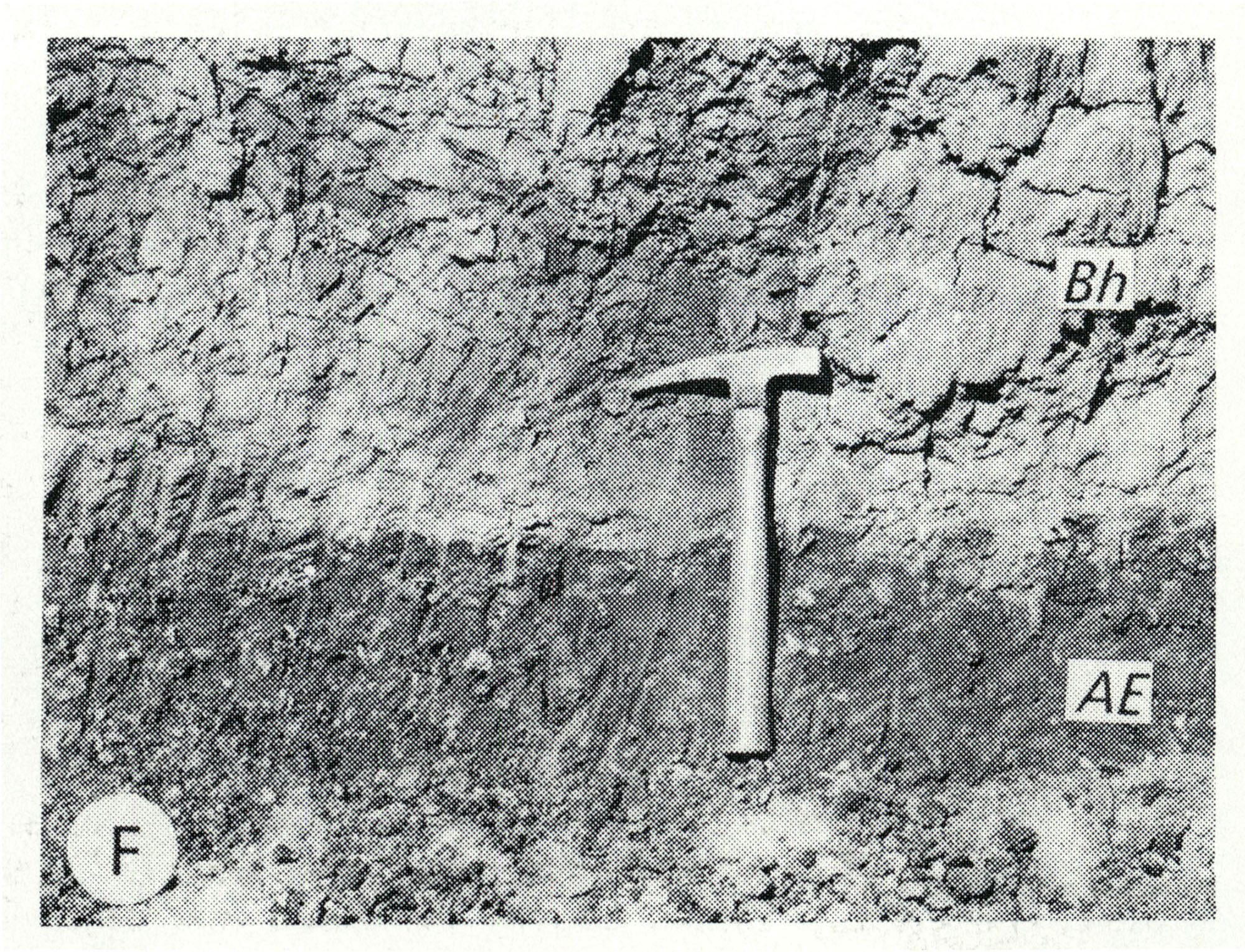
1.13 MB | Alan.Myers | Fig. Q-1F -- Harkness Silt Member of the ~ansan Banner Formation (Bh) overlying the Afton Soil developed on gravel of the Nebraskan Enion Formation (AE); in a roadcut at the Zion Church, 2 miles southeast of Marblehead, Adams County (Willman and Frye,... | 1 |
| 20:32, 8 July 2020 | C605-Figure-05b.jpg (file) |  |
1.13 MB | Alan.Myers | 1 | |
| 18:38, 4 April 2016 | Figure K-1C.jpg (file) |  |
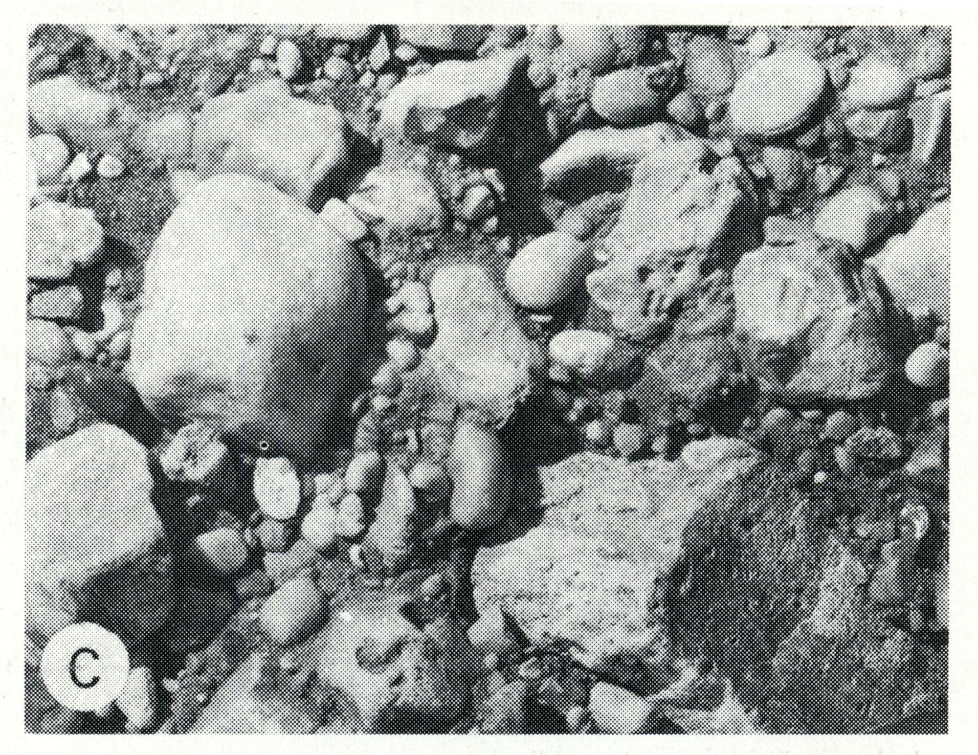
1.14 MB | Alan.Myers | Fig. K-1C -- Bedding surface of Mounds Gravel in same pit as exposure B (x1.5). | 1 |
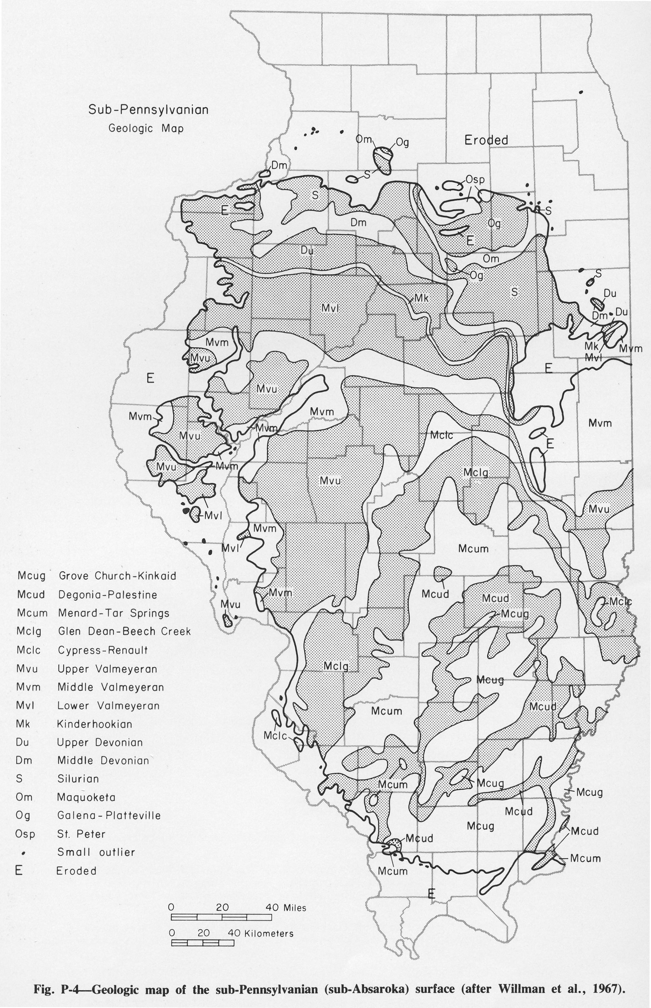
| 19:28, 14 October 2015 | Figure P-4.jpg (file) |  |
1.15 MB | Jennifer.Obrad | P-4 -- Geologic map of the sub-Pennsylvanian (sub-Absaroka) surface (after Willman et al., 1967) | 1 |
| 22:06, 15 September 2022 | Fig 0870 Photos 002.JPG (file) |  |
1.15 MB | Jennifer.Obrad | 1 | |
| 15:15, 9 July 2020 | C605-Figure-20.jpg (file) |  |
1.15 MB | Alan.Myers | 1 | |
| 13:11, 5 April 2016 | Figure Q-1E.jpg (file) |  |
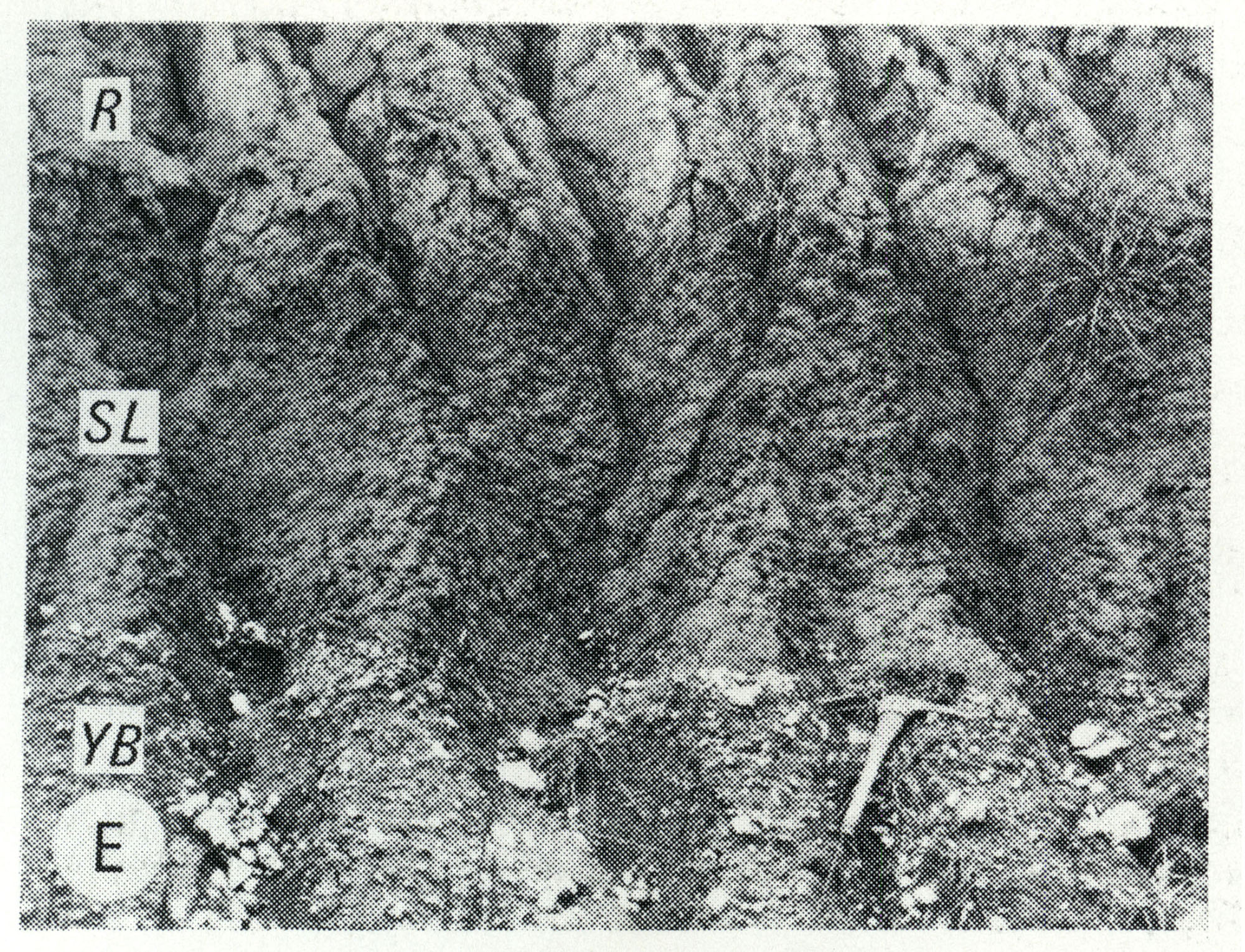
1.16 MB | Alan.Myers | Fig. Q-1E -- Wisconsinan Roxana Silt (R), Sangamon Soil developed in the Illinoian Loveland Silt (SL) and Yarmouth Soil developed in till of the Kansan Banner Formation (YB); in a roadcut at Independence, 5 miles south of Pittsfield, Pike County (Frye... | 1 |
| 13:10, 5 April 2016 | Figure Q-1D.jpg (file) |  |
1.16 MB | Alan.Myers | Fig. Q-1D -- Illinoian Glasford Formation (Hagarstown Member) showing steeply dipping sand and gravel (crevasse deposit) in a mound in the Kaskaskia Ridged Drift area, 2 miles southwest of Lakewood, Shelby County. | 1 |
| 16:38, 23 December 2020 | Penn carbondale 4-27.jpg (file) |  |
1.17 MB | Jennifer.Obrad | 1 | |
| 18:15, 4 April 2016 | Figure C-1B.jpg (file) |  |
1.18 MB | Alan.Myers | Fig. C-1B -- Cambrian-Ordovician unconformity showing well bedded Oneota Dolomite overlying massive Potosi Dolomite in a quarry in Lee County, 6 miles south of Rochelle, Ogle County (Willman and Templeton, 1951, p. 113). | 1 |
| 16:58, 19 April 2016 | 104-Figure 18.jpg (file) |  |
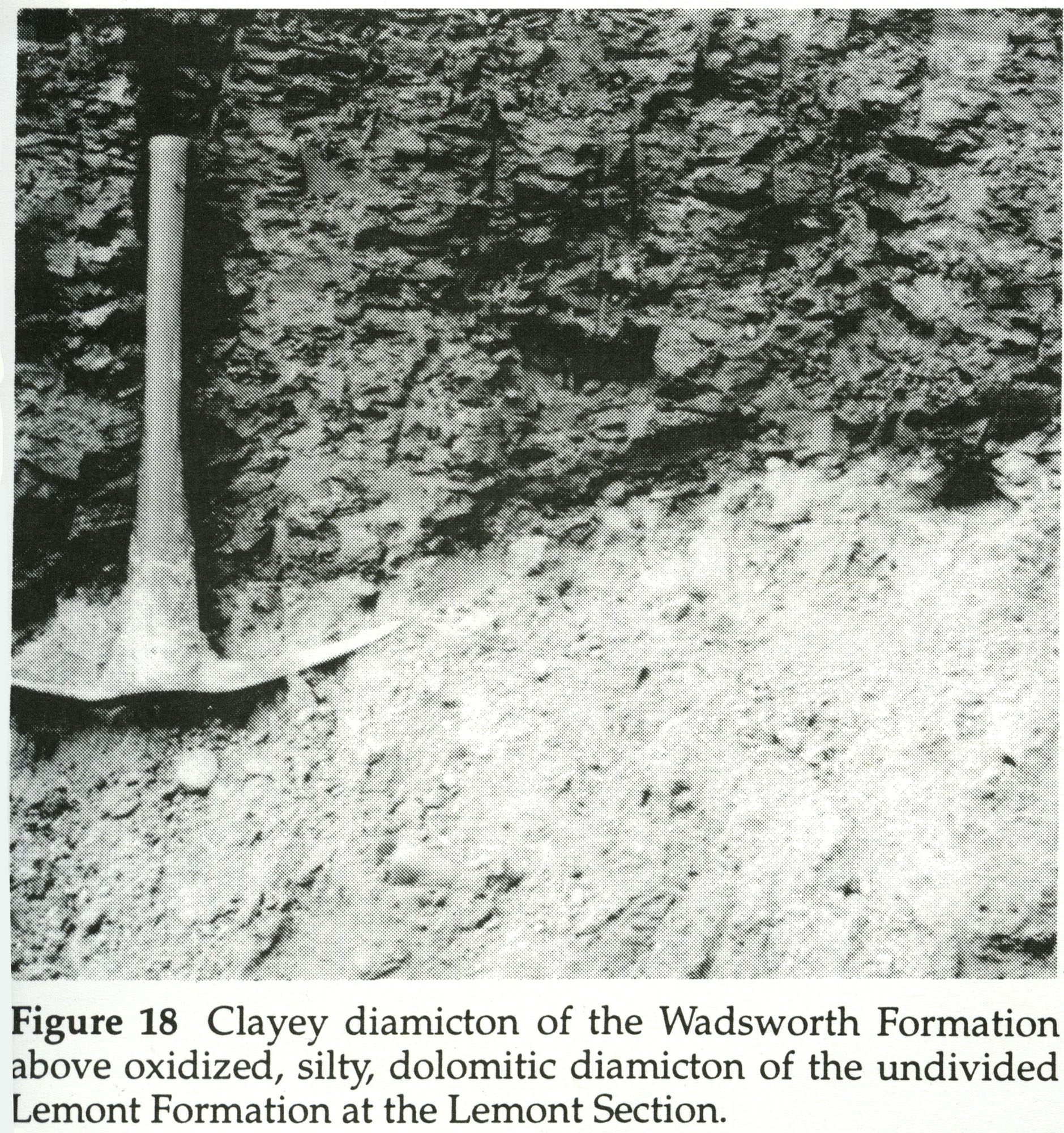
1.18 MB | Illex-gron | Figure 18 -- Clayey diamicton of the Wadsworth Formation above oxidized, silty, dolomitic diamicton of the undivided Lemont Formation at the Lemont Section. | 1 |
| 13:22, 5 April 2016 | Figure S-2F.jpg (file) |  |
1.19 MB | Alan.Myers | Fig. S-2F -- Dense, argillaceous dolomite containing chert nodules characteristic of Racine interreef facies in the Chicago area. The outer, porous parts of the nodules are blackened by air pollutants. | 1 |
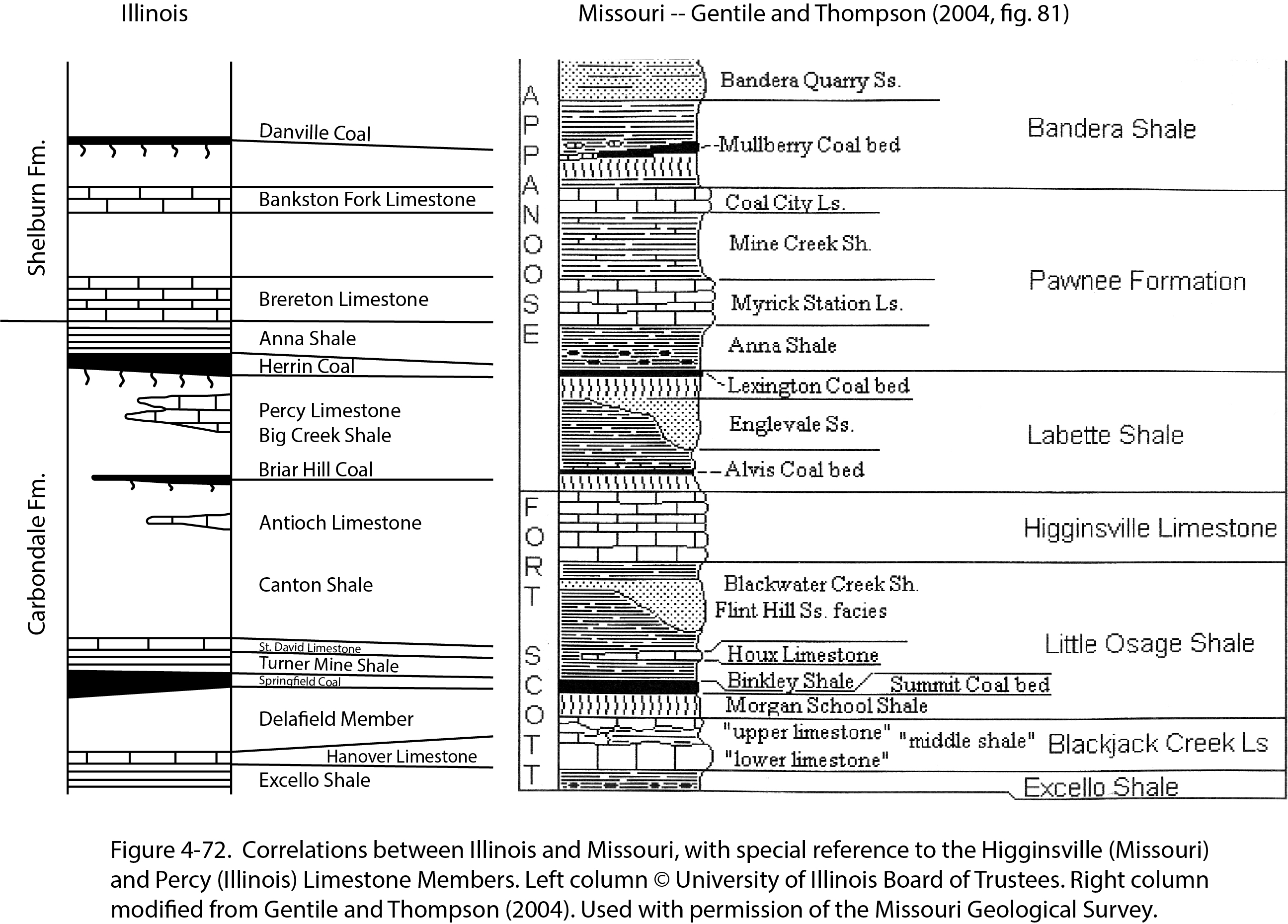
| 21:12, 4 January 2021 | Penn carbondale 4-72.jpg (file) |  |
1.2 MB | Jennifer.Obrad | 1 | |
| 21:09, 26 January 2021 | Penn carbondale 4-14.jpg (file) |  |
1.21 MB | Jennifer.Obrad | 1 | |
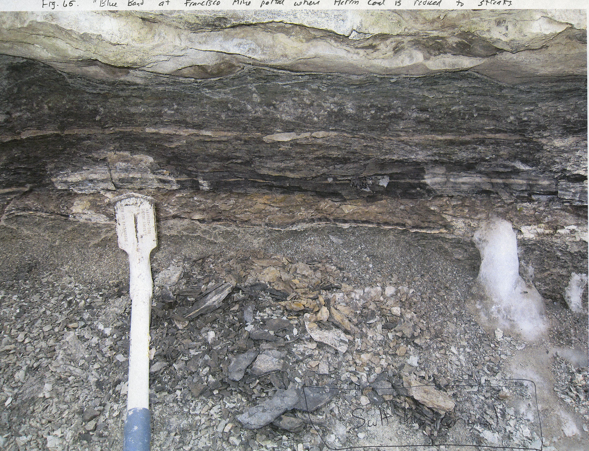
| 19:15, 8 March 2016 | Penn carb fig65.jpg (file) |  |
1.22 MB | Jennifer.Obrad | "Blue band" at Francisco Mine portal where Herrin Coal is reduced to streaks | 1 |
| 20:39, 22 December 2020 | Penn carbondale 4-1.jpg (file) |  |
1.23 MB | Jennifer.Obrad | 1 | |
| 19:14, 10 July 2020 | C605-Figure-28.jpg (file) |  |
1.24 MB | Alan.Myers | 1 | |
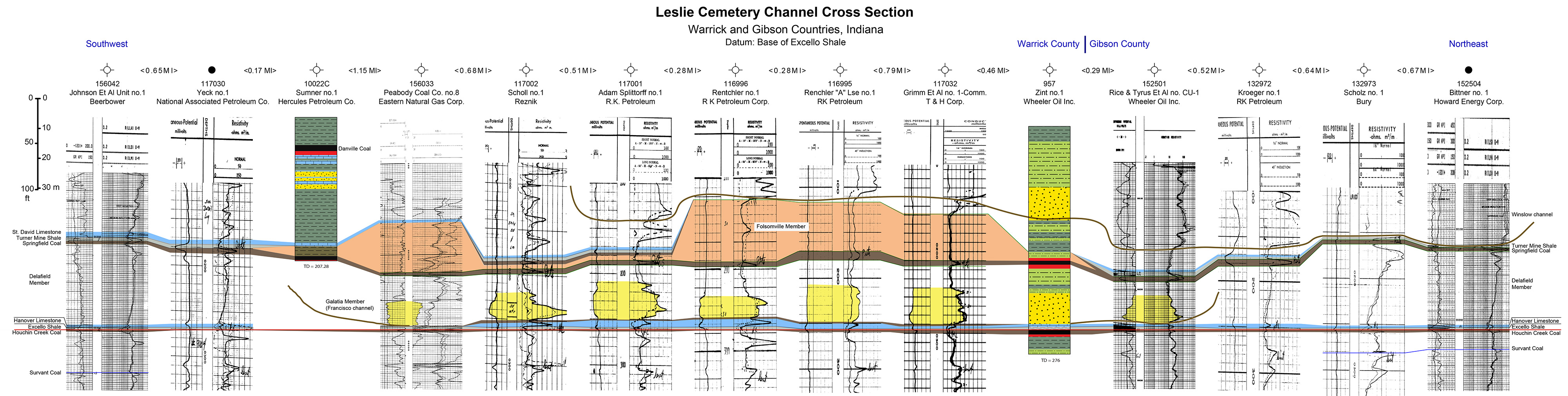
| 20:02, 10 July 2020 | C605-Plate 6 - Leslie Cemetery Channel Xsec.jpg (file) | 1.24 MB | Alan.Myers | 1 | ||
| 23:20, 8 March 2016 | Penn carb fig2.jpg (file) |  |
1.26 MB | Jennifer.Obrad | 1 | |
| 13:16, 5 April 2016 | Figure S-2E.jpg (file) |  |
1.26 MB | Alan.Myers | Fig. S-2E -- Mottled, porous, pure dolomite characteristic of Racine reef facies in the Chicago area (x 1). | 1 |
| 21:21, 17 July 2020 | C605-Figure-03.jpg (file) |  |
1.29 MB | Alan.Myers | 2 | |
| 17:46, 19 April 2016 | 104-Figure 28.jpg (file) |  |
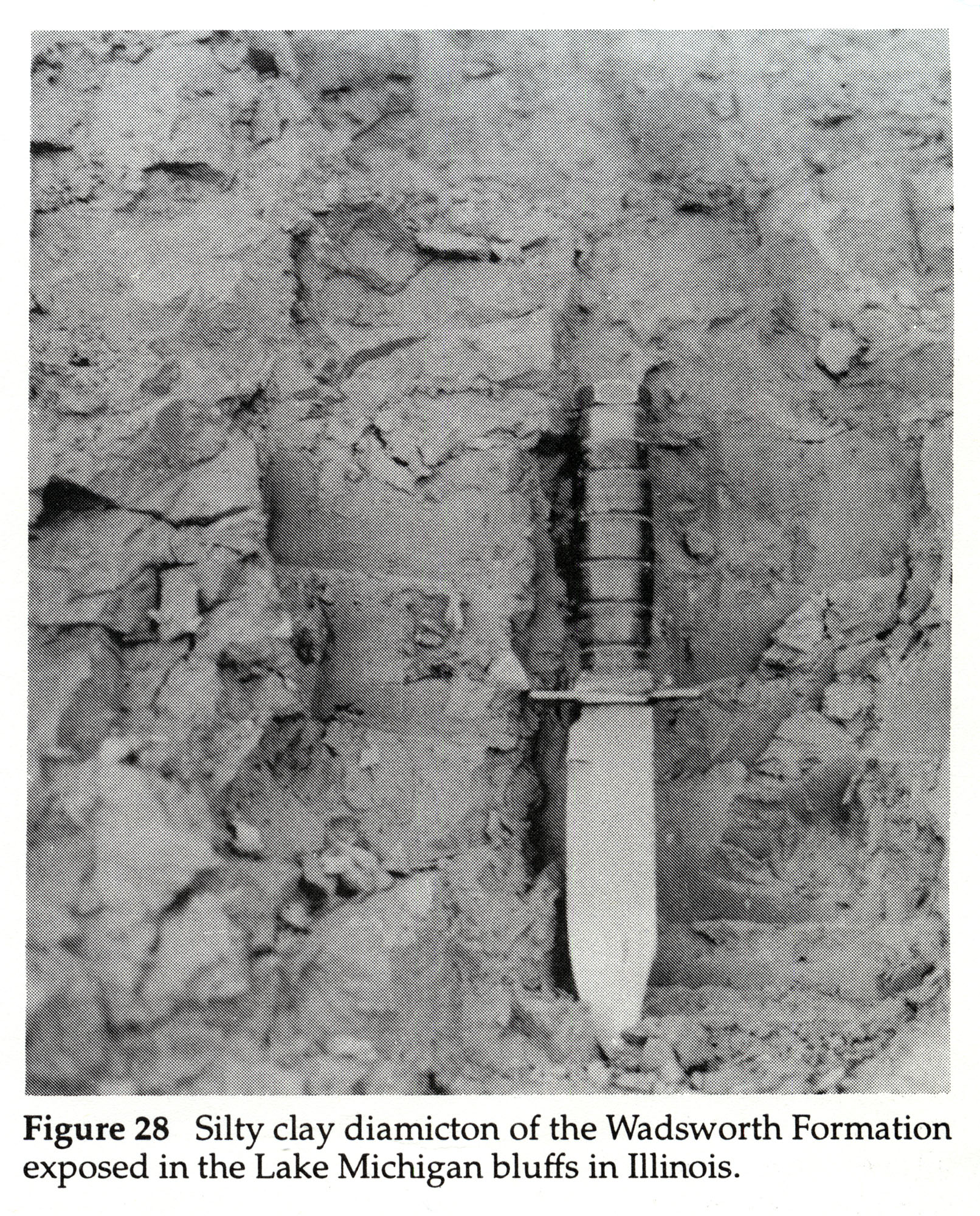
1.29 MB | Illex-gron | Figure 28 -- Silty clay diamicton of the Wadsworth Formation exposed in the Lake Michigan bluffs in Illinois. | 1 |
| 17:19, 19 April 2016 | 104-Figure 26.jpg (file) |  |
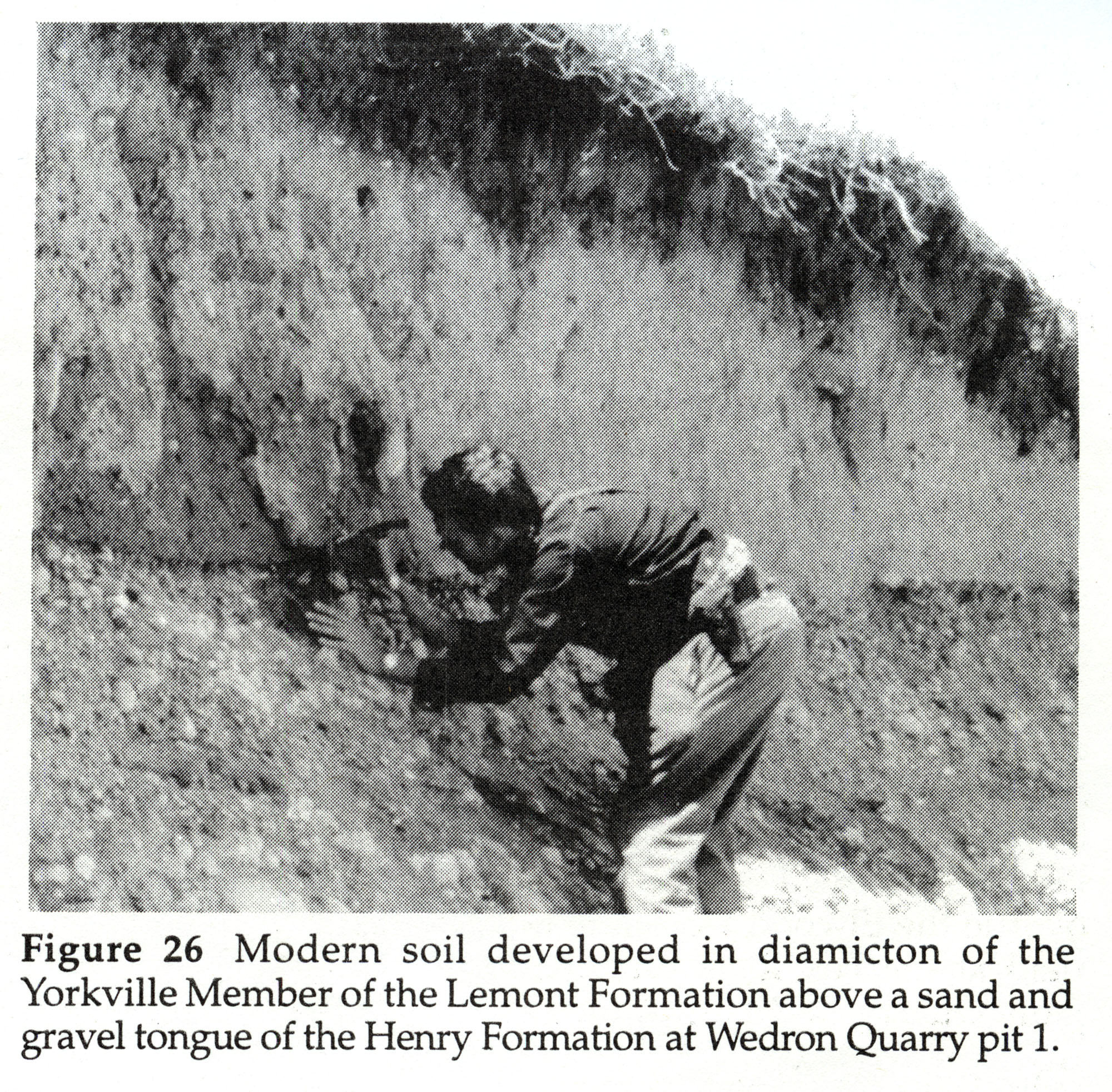
1.29 MB | Illex-gron | Figure 26 -- Modern soil developed in diamicton of the Yorkville Member of the Lemont Formation above a sand and gravel tongue of the Henry Formation at Wedron Quarry pit 1. | 1 |
| 13:14, 5 April 2016 | Figure S-2B.jpg (file) |  |
1.29 MB | Alan.Myers | Fig. S-2B -- Steeply dipping, well bedded dolomite forming the fiank of a Racine (Niagaran) reef, in the Material Service Corporation quarry at Thornton, Cook County. | 1 |
| 16:16, 23 December 2020 | Penn carbondale 4-22.jpg (file) |  |
1.31 MB | Jennifer.Obrad | 1 | |
| 21:39, 4 January 2021 | Penn carbondale 4-81.jpg (file) |  |
1.32 MB | Jennifer.Obrad | 1 | |
| 21:10, 26 January 2021 | Penn carbondale 4-15.jpg (file) |  |
1.32 MB | Jennifer.Obrad | 1 | |
| 13:14, 5 April 2016 | Figure S-2A.jpg (file) |  |
1.33 MB | Alan.Myers | Fig. S-2A -- Massive dolomite in the core of a Racine (Niagaran) reef, at the top of the Material Service Corporation (Stearns) quarry on Archer Avenue at 28th Street, Chicago. | 1 |
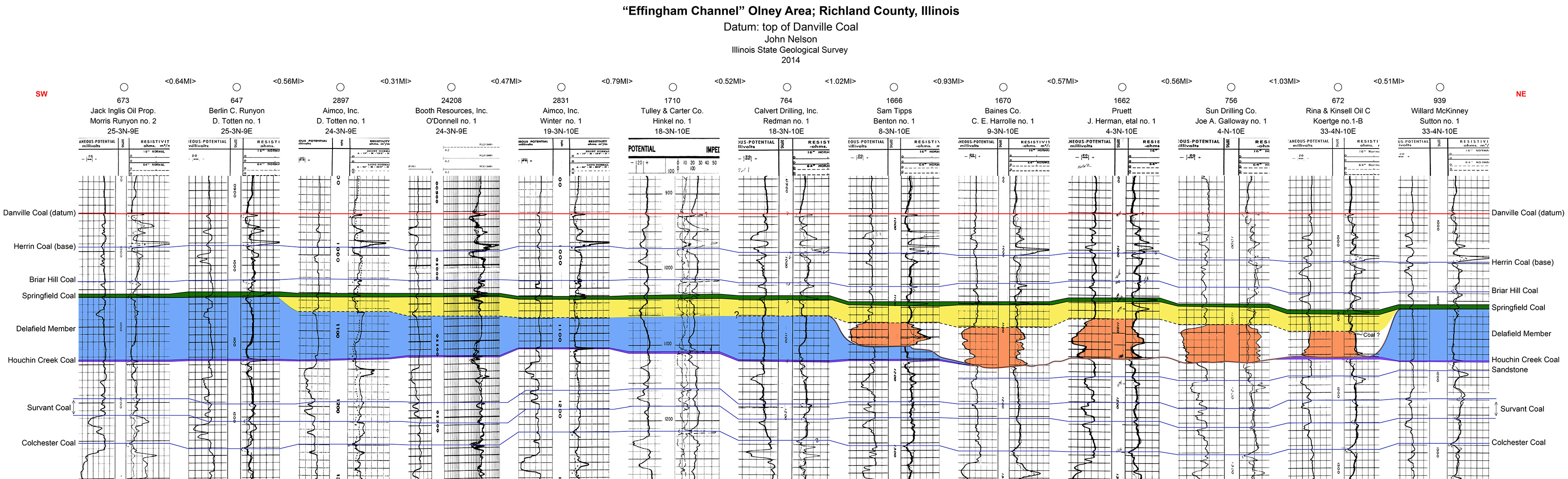
| 19:53, 10 July 2020 | C605-Plate 4 - Effingham Channel Olney Xsec.jpg (file) |  |
1.33 MB | Alan.Myers | 1 | |
| 17:01, 19 April 2016 | 104-Figure 20.jpg (file) |  |
1.34 MB | Illex-gron | Figure 20 -- Unoxidized, silty, dolomitic diamicton of the undivided Lemont Formation exposed in O'hare reservoir excavation. | 1 |
| 14:40, 9 July 2020 | C605-Figure-11.jpg (file) |  |
1.34 MB | Alan.Myers | 1 | |
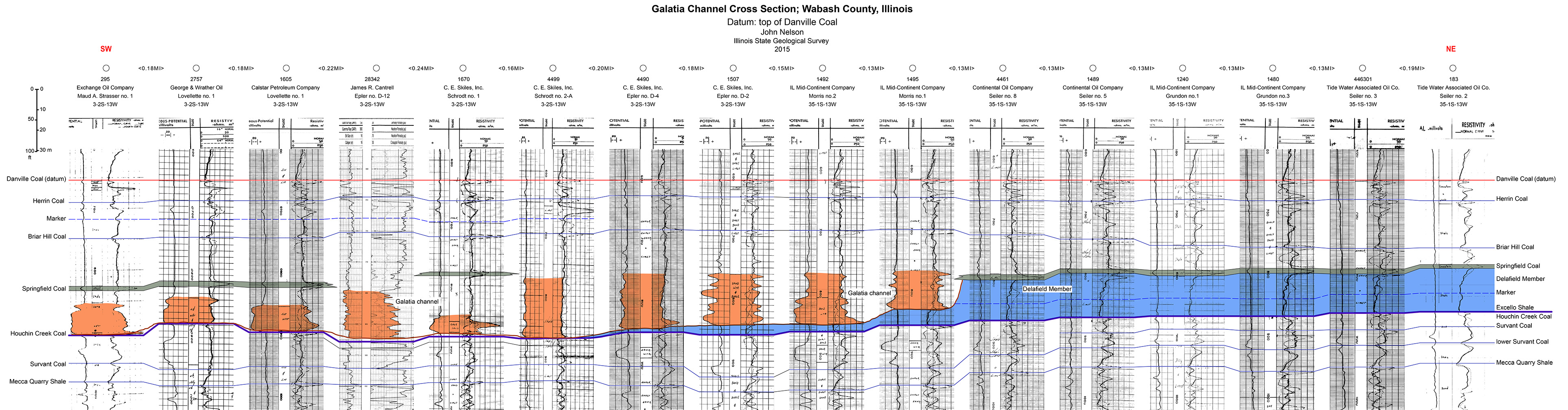
| 19:25, 9 July 2020 | C605-Plate 3 -Galatia Chanel Xsec Wabash Co.jpg (file) | 1.36 MB | Alan.Myers | 1 | ||
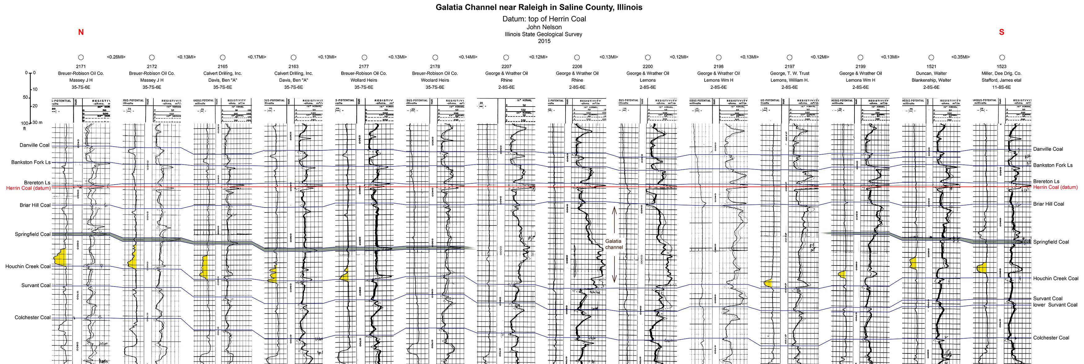
| 18:59, 9 July 2020 | C605-Plate 2 - Galatia Channel Xsec Saline Co.jpg (file) |  |
1.37 MB | Alan.Myers | 1 | |
| 18:35, 14 October 2015 | Figure P-3D.jpg (file) |  |
1.38 MB | Jennifer.Obrad | P-3D -- The Sub-Absaroka unconformity showing Pennsylvanian strata (Caseyville Formation) truncating Mississippian strata (Kinkaid Limestone) in a roadcut of U.S. Highway 51, north of Anna, Union County. | 1 |
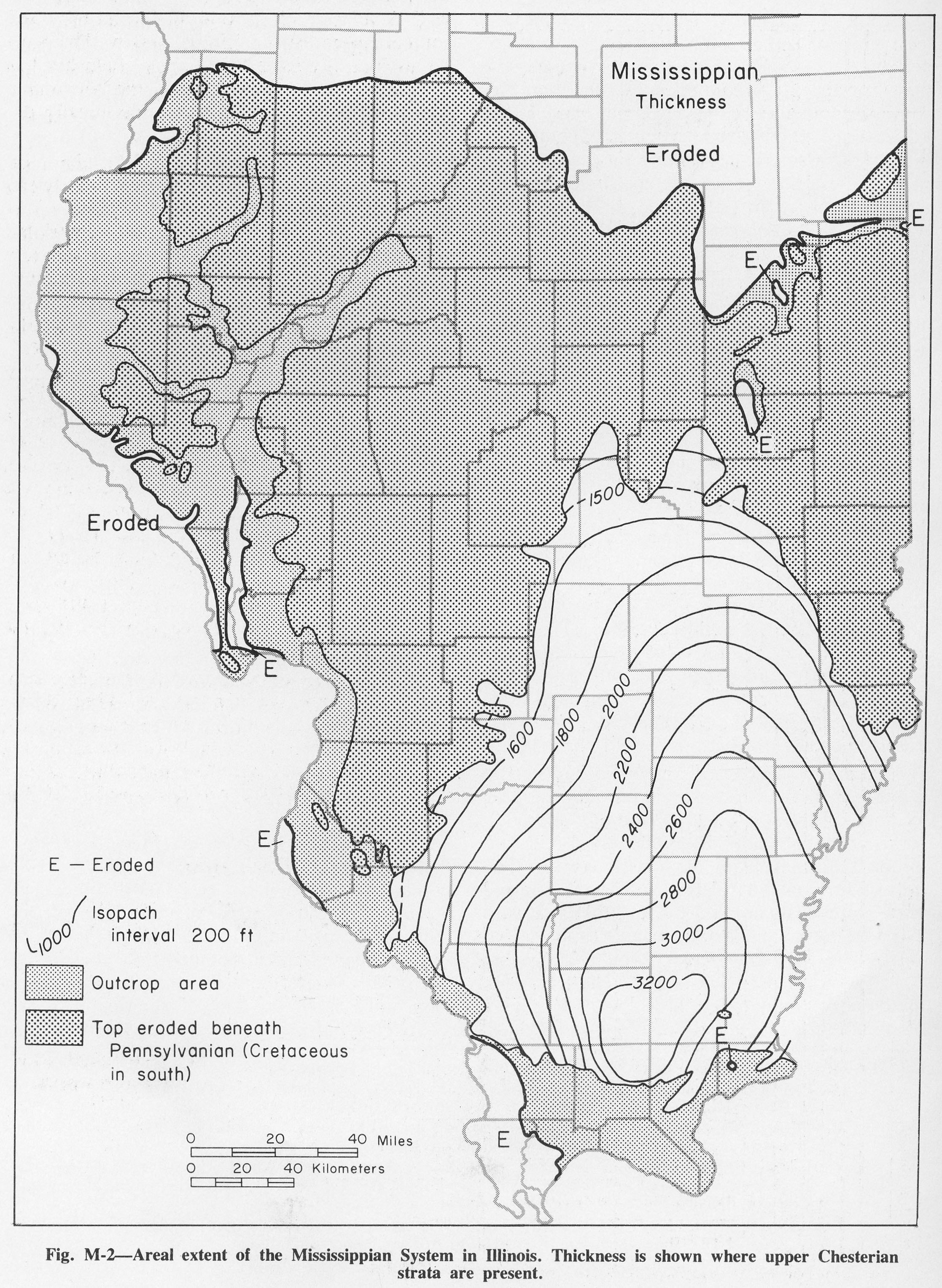
| 13:04, 4 April 2016 | Figure M-2.jpg (file) |  |
1.38 MB | Alan.Myers | Fig. M-2 -- Areal extent of the Mississippian System in Illinois. Thickness is shown where upper Chesterian strata are present. | 1 |
| 13:15, 5 April 2016 | Figure S-2C.jpg (file) |  |
1.38 MB | Alan.Myers | Fig. S-2C -- Massive Marcus Dolomite in a quarry 3 miles east of Fulton, Whiteside County. | 1 |
| 17:52, 19 April 2016 | 104-Figure 31.jpg (file) |  |
1.39 MB | Illex-gron | Figure 31 -- Ripple and planar bedded silt, clay, and fine sand of the Equality Formation. | 1 |
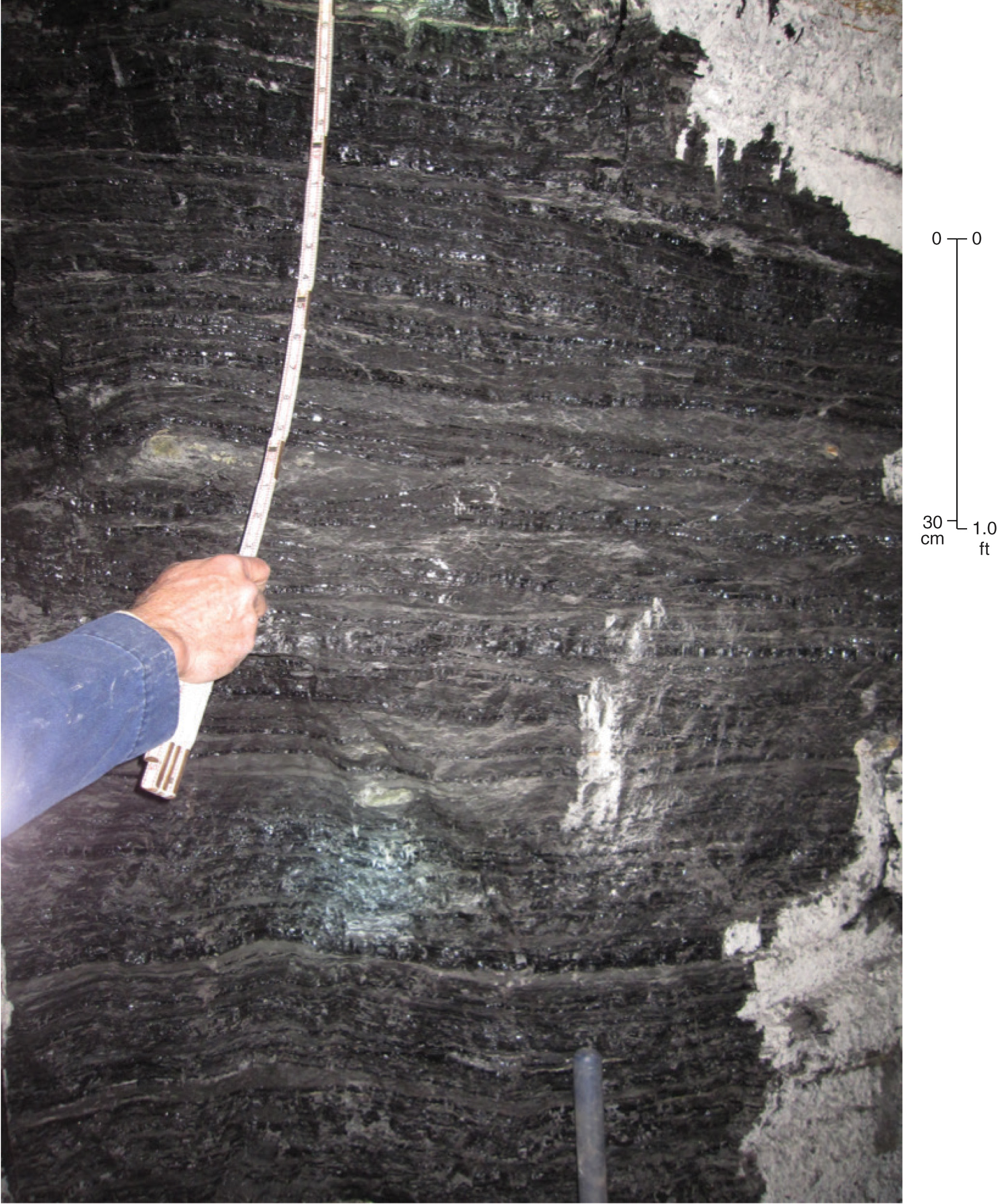
| 19:14, 8 March 2016 | Penn carb fig64.jpg (file) |  |
1.39 MB | Jennifer.Obrad | Photograph of hand speciman of "Blue band" | 1 |
| 17:00, 19 April 2016 | 104-Figure 19.jpg (file) |  |
1.41 MB | Illex-gron | Figure 19 -- Diamicton (subglacial till) of the Haeger Member of the Lemont Formation overlies the proglacial (ice proximal) sand and gravel of the Beverly Tongue of the Henry Formation at the Beverly Sand and Gravel Pit Section. | 1 |
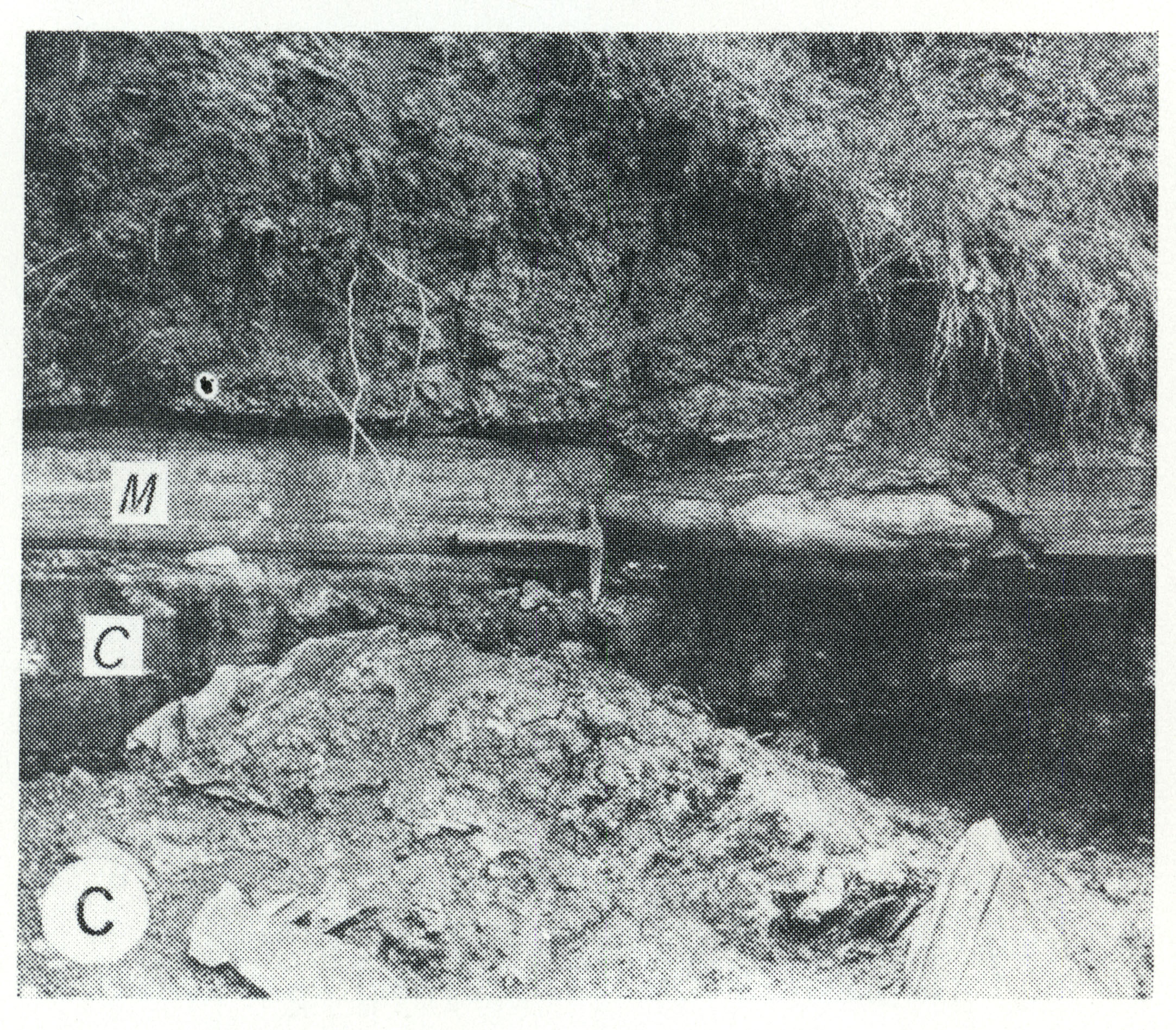
| 19:03, 14 October 2015 | Figure P-3C.jpg (file) |  |
1.41 MB | Jennifer.Obrad | P-3C -- Mecca Quarry Shale Member (M) of the Carbondale Formation in which a large limestone concretion is present (at the hammer), overlying the Colchester (No. 2) Coal Member (C) just south of Viola, Mercer County. | 1 |