File list
Jump to navigation
Jump to search
This special page shows all uploaded files.
| Date | Name | Thumbnail | Size | User | Description | Versions |
|---|---|---|---|---|---|---|
| 19:35, 1 April 2016 | Figure 13.jpg (file) |  |
574 KB | Alan.Myers | Fig. 13 -- Geologic cross section along the lines shown in figure 12 (after Willman er al., 1967). | 1 |
| 15:57, 1 April 2016 | Figure 11.jpg (file) |  |
1.89 MB | Alan.Myers | Fig. 11 -- Generalized surficial geology of Illinois. In uneroded areas the loess thins from 25-100 feet thick in the bluffs of the major valleys to 1-2 feet in areas farthest from valleys. | 1 |
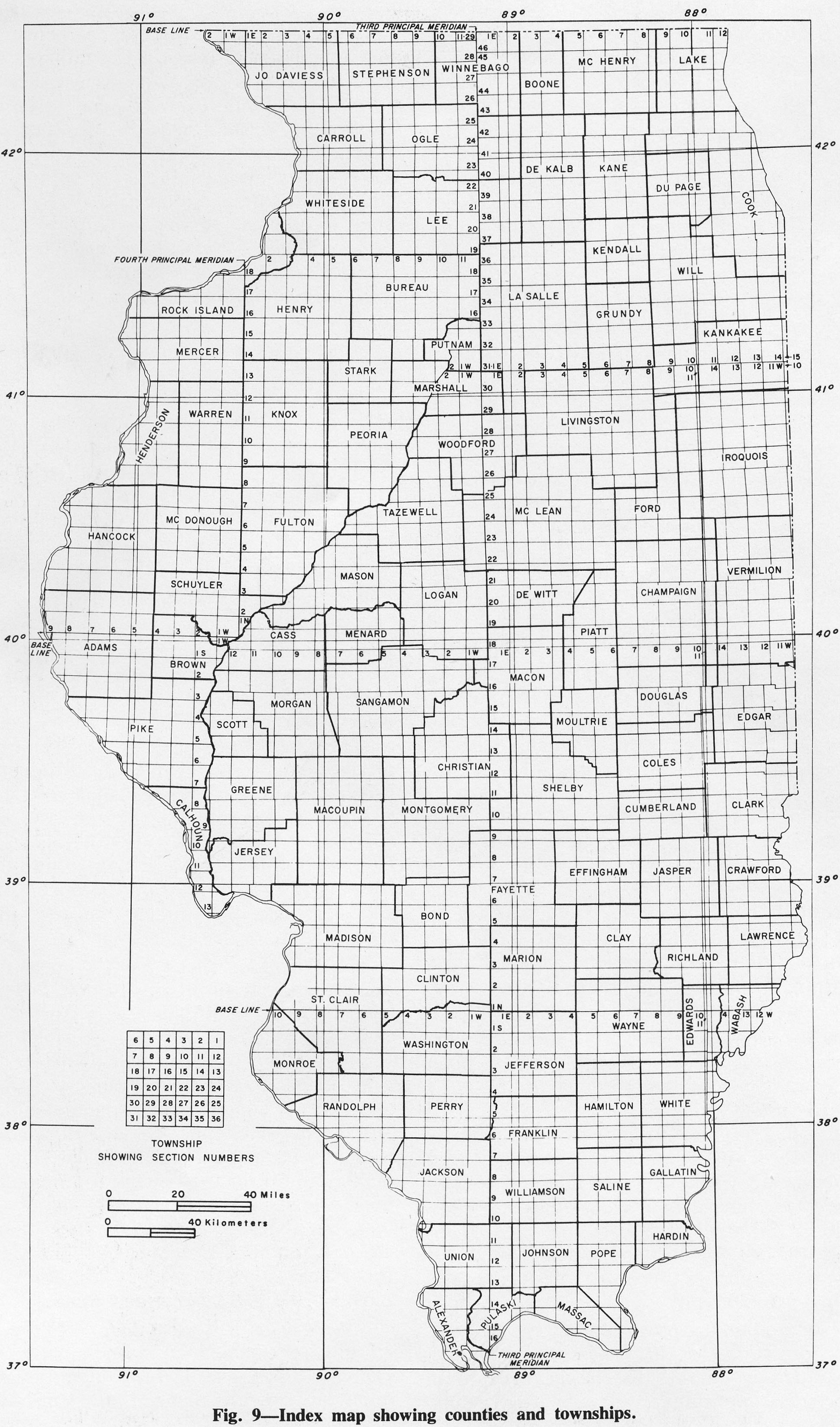
| 15:54, 1 April 2016 | Figure 9.jpg (file) |  |
895 KB | Alan.Myers | Fig. 9 -- Index map showing counties and townships. | 1 |
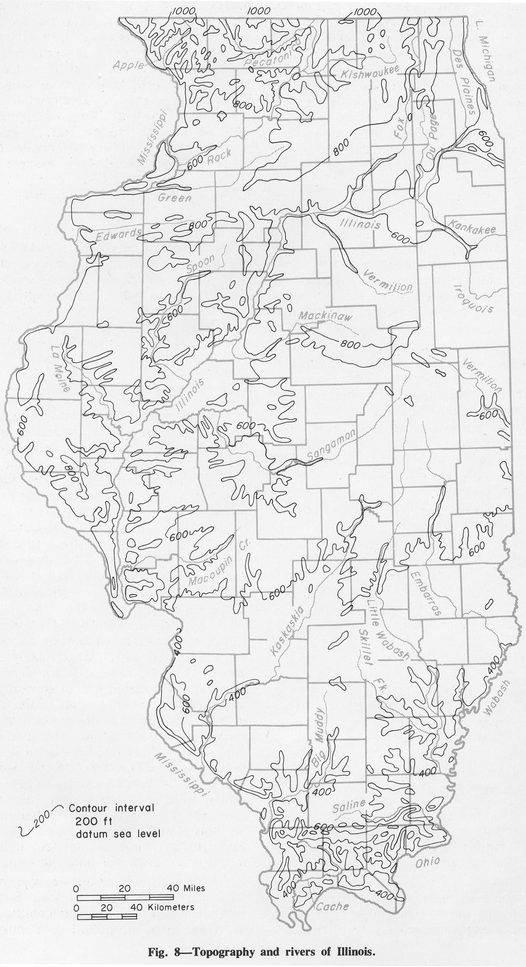
| 15:53, 1 April 2016 | Figure 8.jpg (file) |  |
834 KB | Alan.Myers | Fig. 8 -- Topography and rivers of Illinois. | 1 |
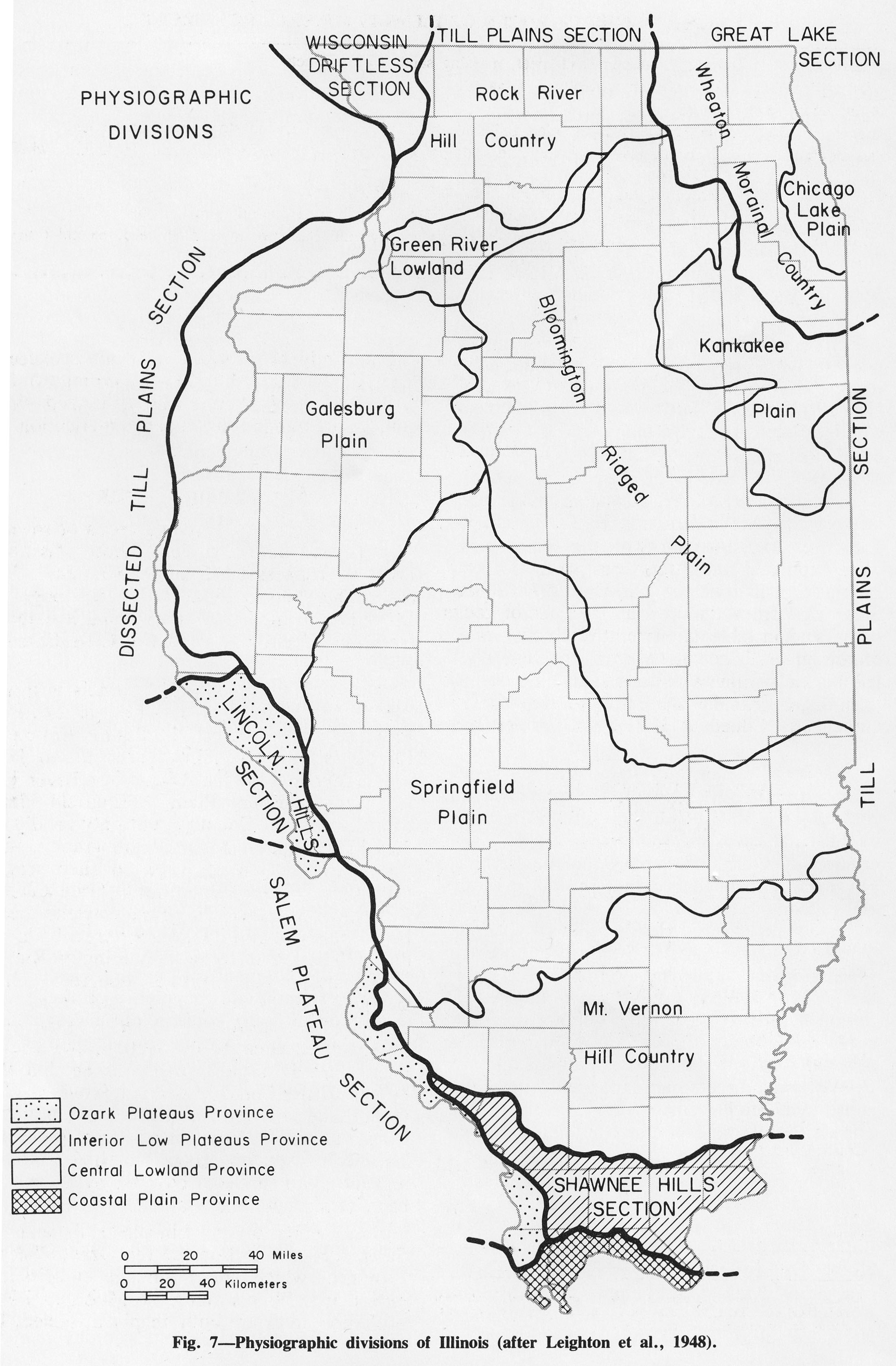
| 15:52, 1 April 2016 | Figure 7.jpg (file) |  |
762 KB | Alan.Myers | Fig. 7 -- Physiographic divisions of Illinois (after Leighton et al., 1948). | 1 |
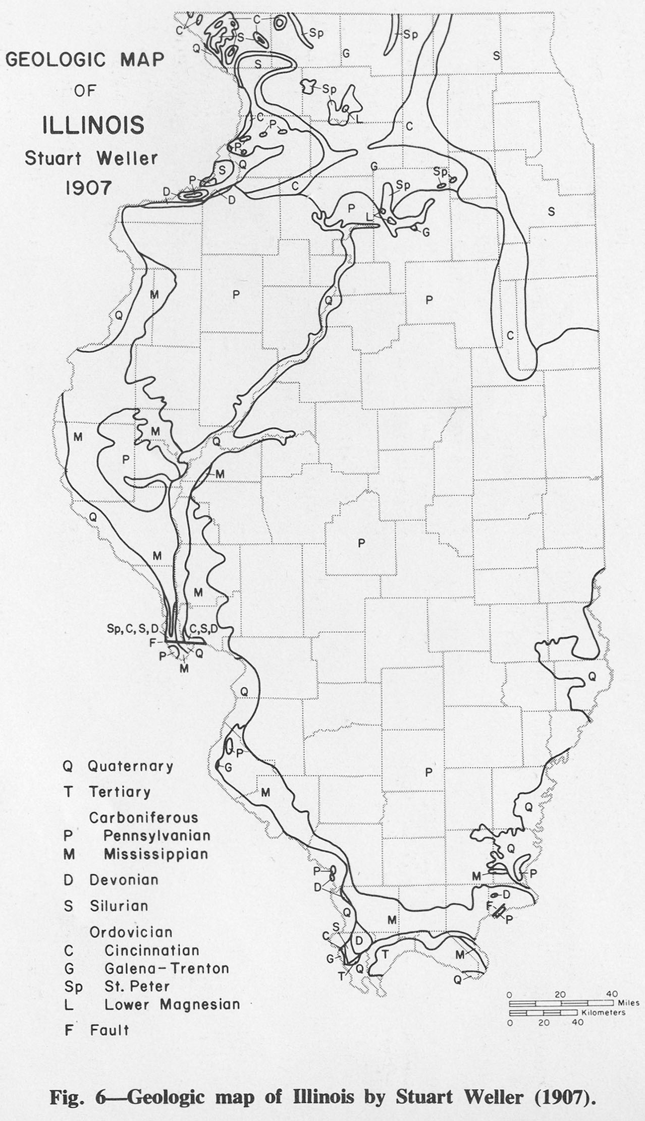
| 15:51, 1 April 2016 | Figure 6.jpg (file) |  |
344 KB | Alan.Myers | Fig. 6 -- Geologic map of Illinois by Stuart Weller (1907). | 1 |
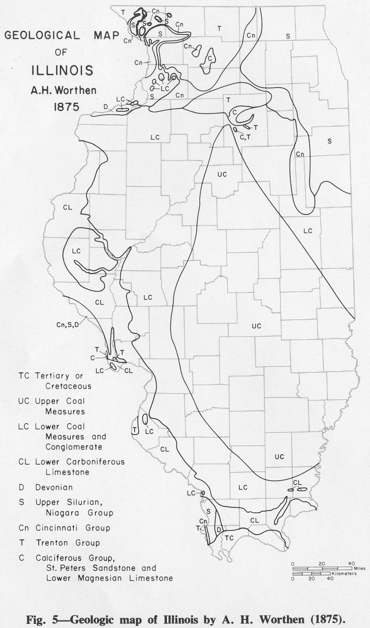
| 15:50, 1 April 2016 | Figure 5.jpg (file) |  |
350 KB | Alan.Myers | Fig. 5 -- Geologic map of Illinois by A. H. Worthen (1875). | 1 |
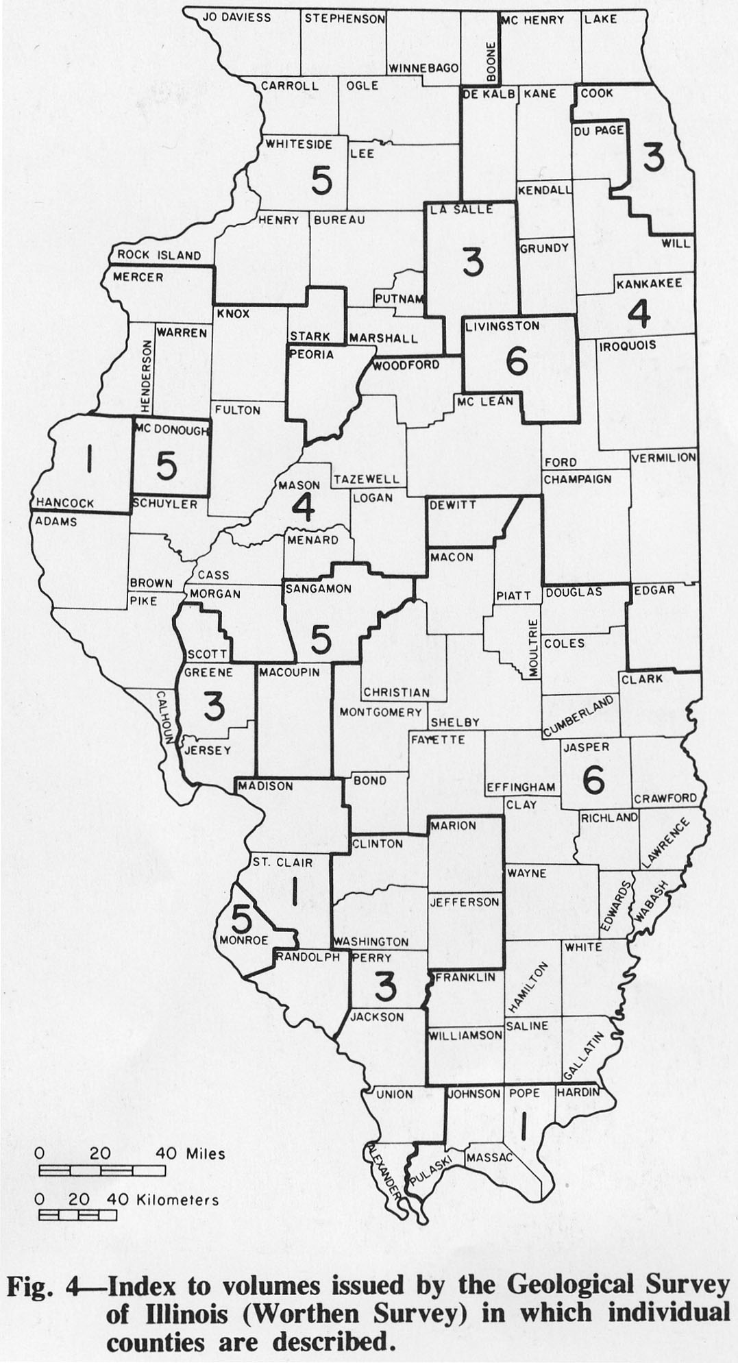
| 15:49, 1 April 2016 | Figure 4.jpg (file) |  |
274 KB | Alan.Myers | Fig. 4 -- Index to volumes issued by the Geological Survey of Illinois (Worthen Survey) in which individual counties are described. | 1 |
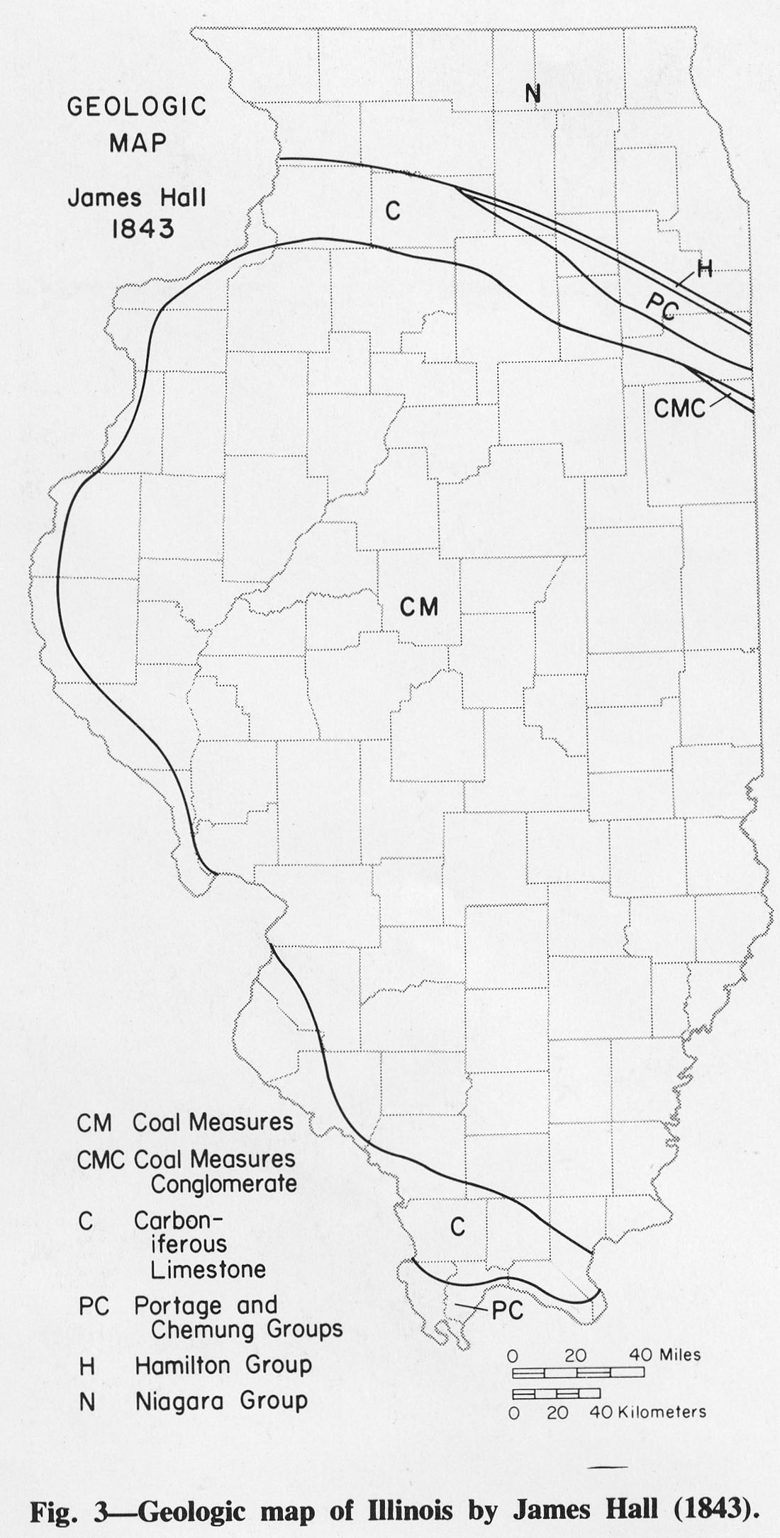
| 15:46, 1 April 2016 | Figure 3.jpg (file) |  |
273 KB | Alan.Myers | Fig. 3 -- Geologic map of Illinois by James Hall (1843). | 1 |
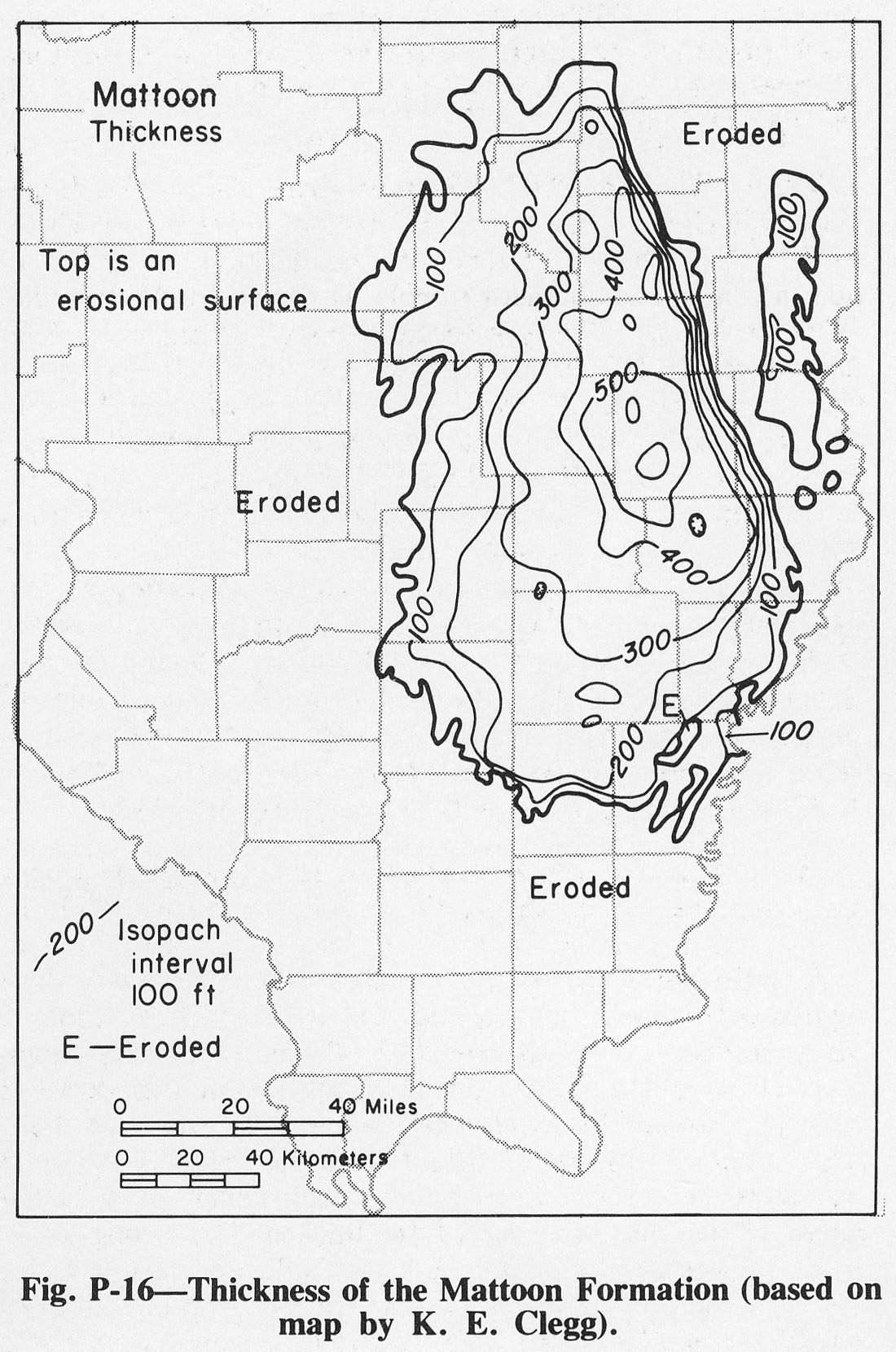
| 15:42, 1 April 2016 | Figure P-16.jpg (file) |  |
320 KB | Illex-gron | Fig. P-16 -- Thickness of the Mattoon Formation (based on map by K. E. Clegg). | 1 |
| 15:41, 1 April 2016 | Figure P-15.jpg (file) |  |
457 KB | Illex-gron | Fig. P-15 -- Thickness of the Bond Formation (based on map by K. E. Clegg). | 1 |
| 15:39, 1 April 2016 | Figure P-14.jpg (file) |  |
535 KB | Illex-gron | Fig. P-14 -- Thickness of the Modesto Formation (based on map by K. E. Clegg). | 1 |
| 15:38, 1 April 2016 | Figure P-10.jpg (file) |  |
507 KB | Illex-gron | Fig. P-10 -- Combined thickness of the Caseyville, Abbott, and Spoon Formations (after Walness, 1955) | 1 |
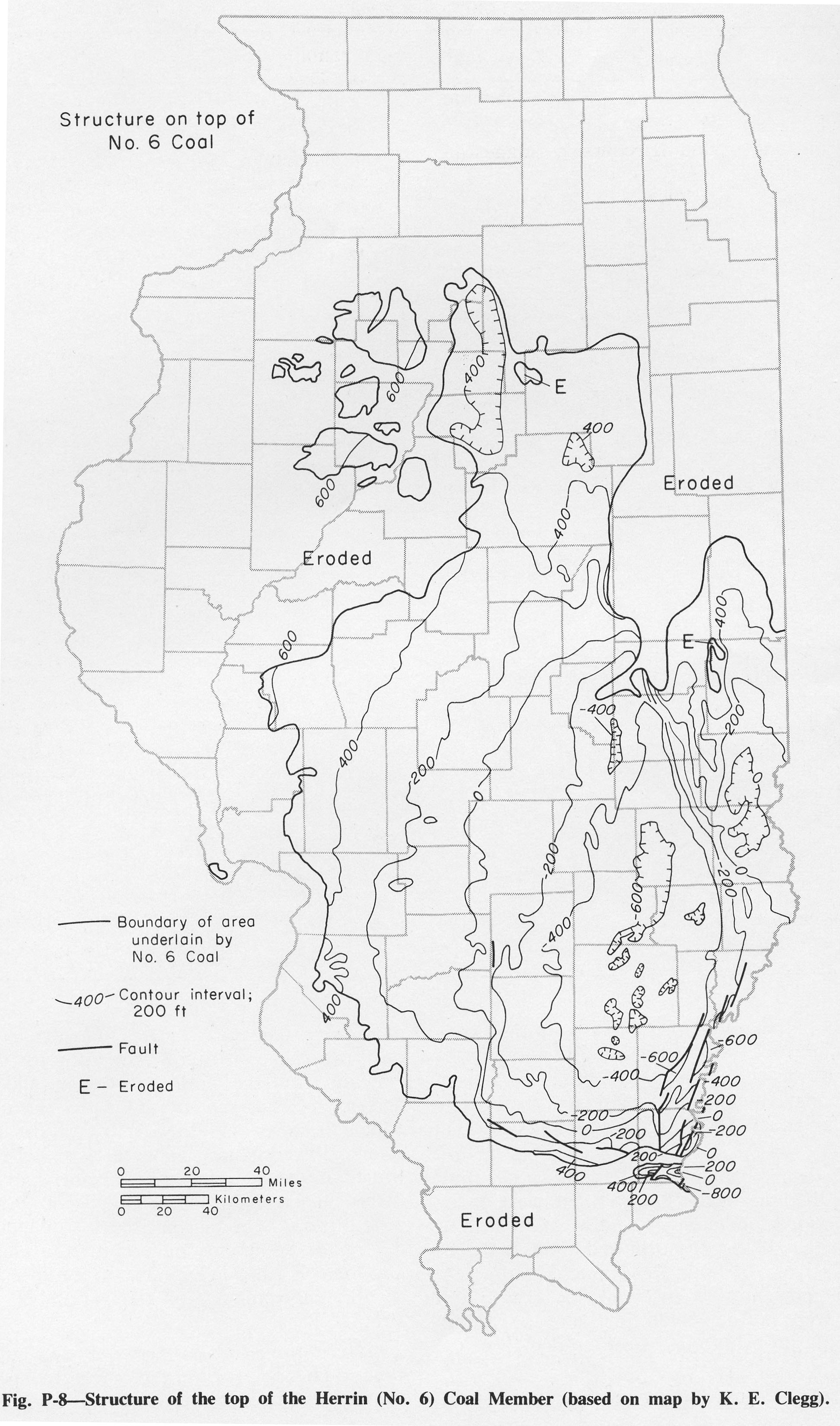
| 15:36, 1 April 2016 | Figure P-8.jpg (file) |  |
714 KB | Illex-gron | Fig. P-8 -- Structure of the top of the Herrin (No. 6) Coal Member (based on map by K. E. Clegg). | 1 |
| 15:31, 1 April 2016 | Figure P-7.jpg (file) |  |
276 KB | Illex-gron | Fig. P-7 -- Arrangement of lithologic units in a cyclothem (after Willman and Payne, 1942). | 1 |
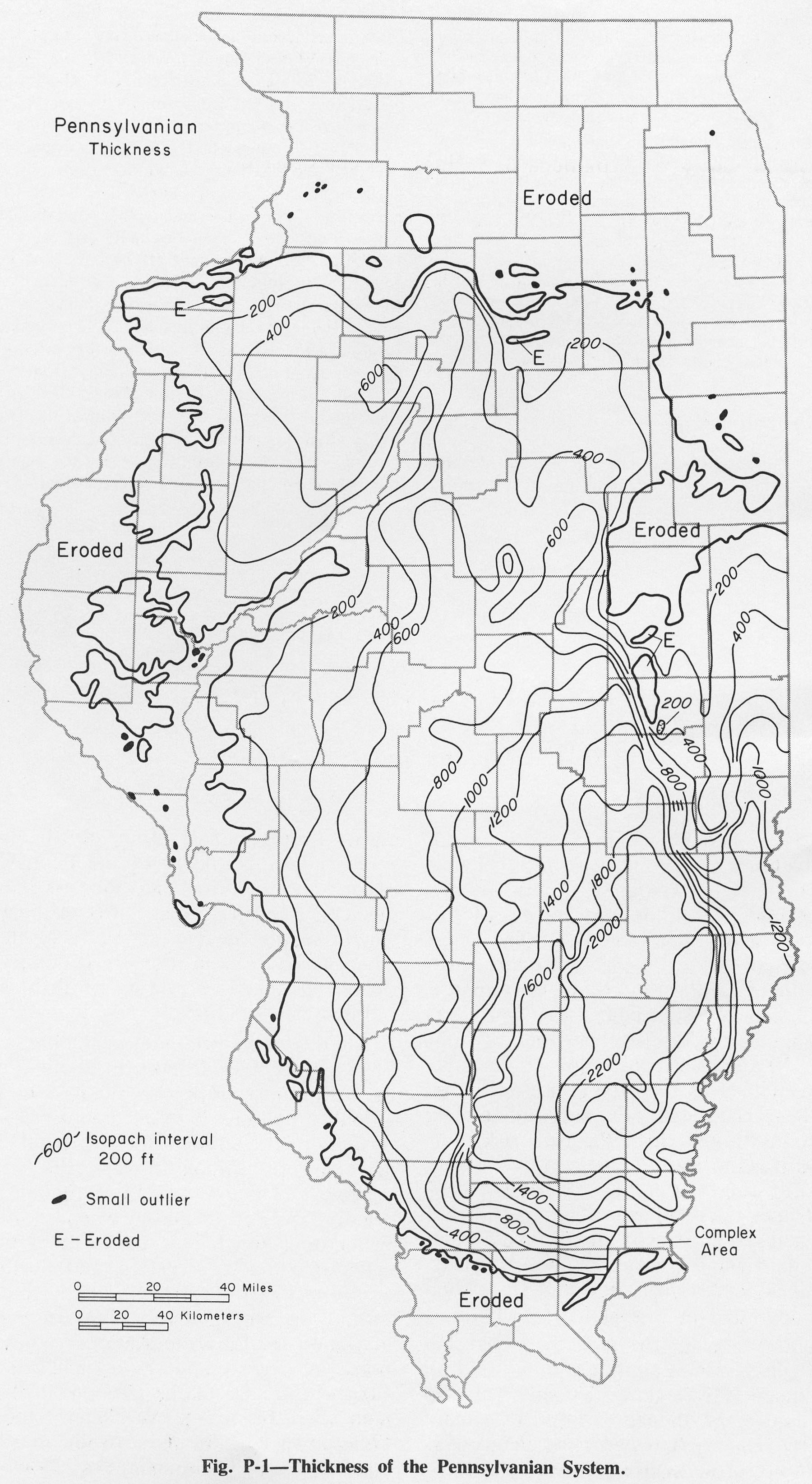
| 15:27, 1 April 2016 | Figure P-1.jpg (file) |  |
753 KB | Illex-gron | Fig. P-1 -- Thickness of the Pennsylvanian System. | 1 |
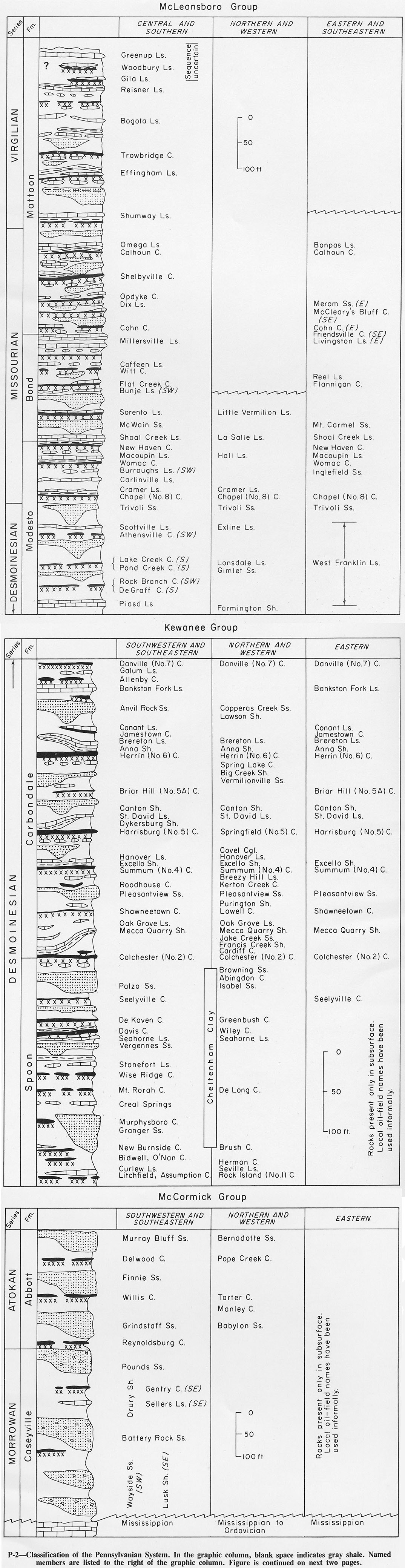
| 15:09, 1 April 2016 | Figure P-2.jpg (file) |  |
765 KB | Illex-gron | Reverted to version as of 14:45, 5 August 2015 | 3 |
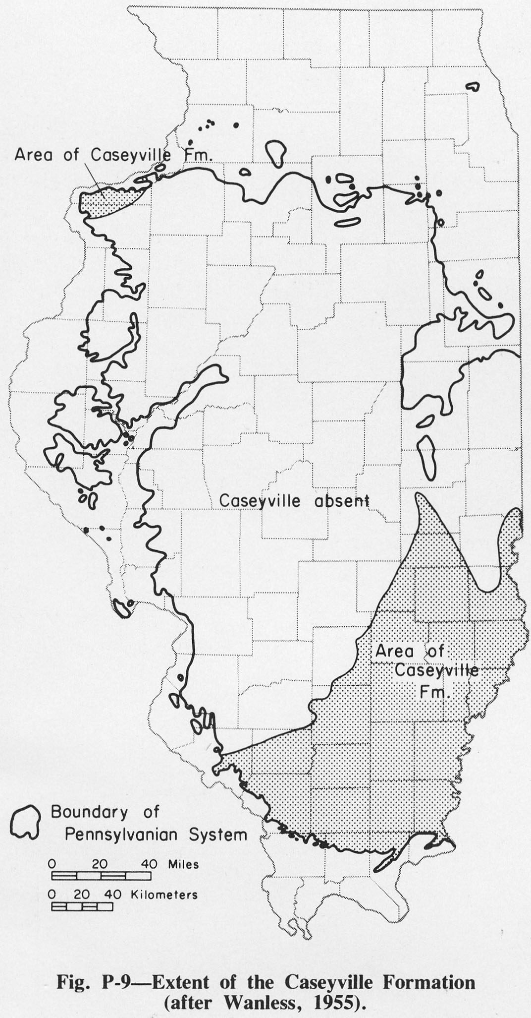
| 14:55, 1 April 2016 | Figure P-9.jpg (file) |  |
334 KB | Illex-gron | Fig. P-4 -- Extent of the Caseyville Formation (after Wanless, 1955). | 1 |
| 14:50, 1 April 2016 | Figure P-3A.jpg (file) |  |
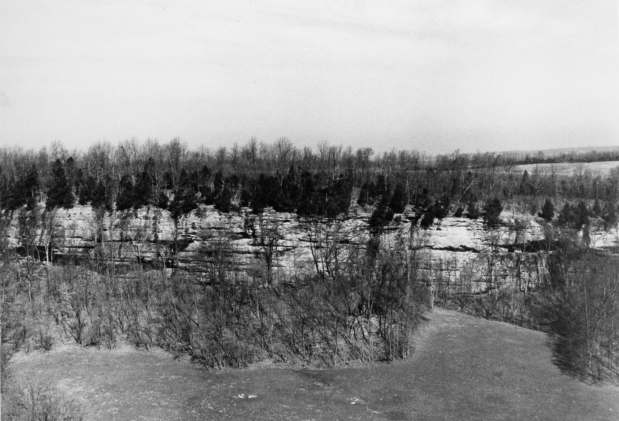
566 KB | Illex-gron | Fig. P-3A -- Battery Rock Sandstone Member of the Caseyville Formation capping an escarpment 8 miles north of Cave in Rock, Hardin County. | 2 |
| 14:29, 1 April 2016 | Figure 12.jpg (file) |  |
808 KB | Illex-gron | Fig. 12 -- Principal geologic structures of Illinois. | 1 |
| 16:31, 31 March 2016 | Figure O-2A.jpg (file) |  |
444 KB | Alan.Myers | Fig. O-2 A -- St. Peter Sandstone in Starved Rock along the Illinois River in Starved Rock State Park, 4 miles south-east of La Salle, La Salle County. | 1 |
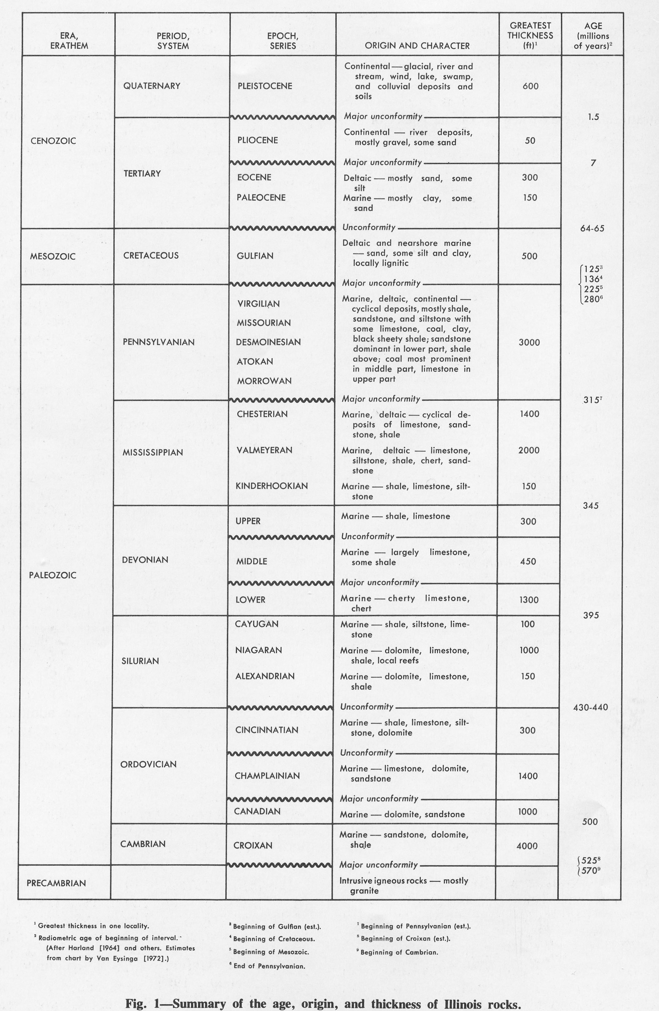
| 16:24, 31 March 2016 | Figure 1.jpg (file) |  |
661 KB | Alan.Myers | Fig. 1 -- Summary of the age, origin, and thickness of Illinois rocks. | 1 |
| 23:20, 8 March 2016 | Penn carb fig2.jpg (file) |  |
1.26 MB | Jennifer.Obrad | 1 | |
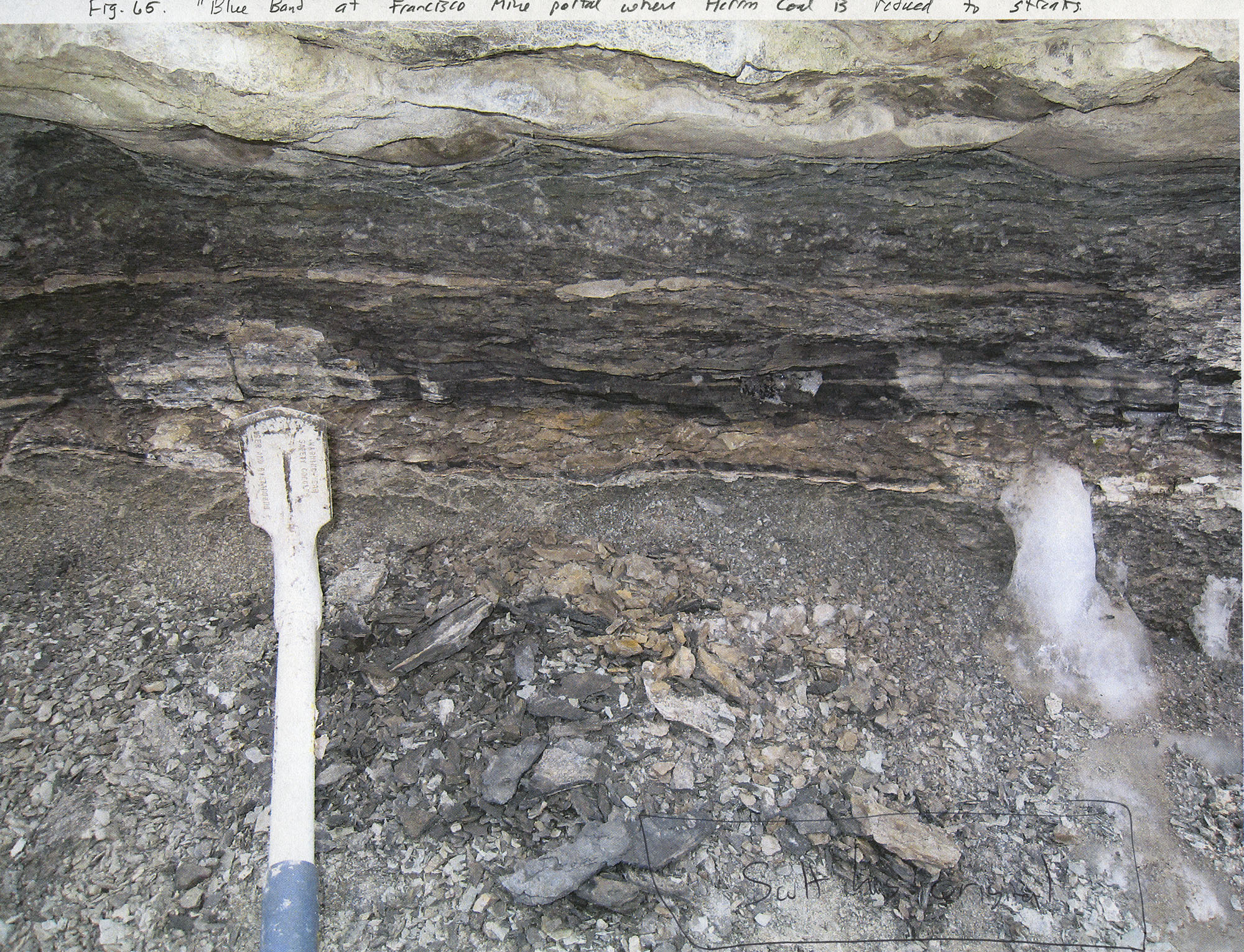
| 19:15, 8 March 2016 | Penn carb fig65.jpg (file) |  |
1.22 MB | Jennifer.Obrad | "Blue band" at Francisco Mine portal where Herrin Coal is reduced to streaks | 1 |
| 19:14, 8 March 2016 | Penn carb fig64.jpg (file) |  |
1.39 MB | Jennifer.Obrad | Photograph of hand speciman of "Blue band" | 1 |
| 19:07, 8 March 2016 | Penn carb fig63.jpg (file) |  |
665 KB | Jennifer.Obrad | Graphic Log of part of continuous core from Madison Coal Corp. borehole #25 in Williamson County. Reference section for Herrin Coal. | 1 |
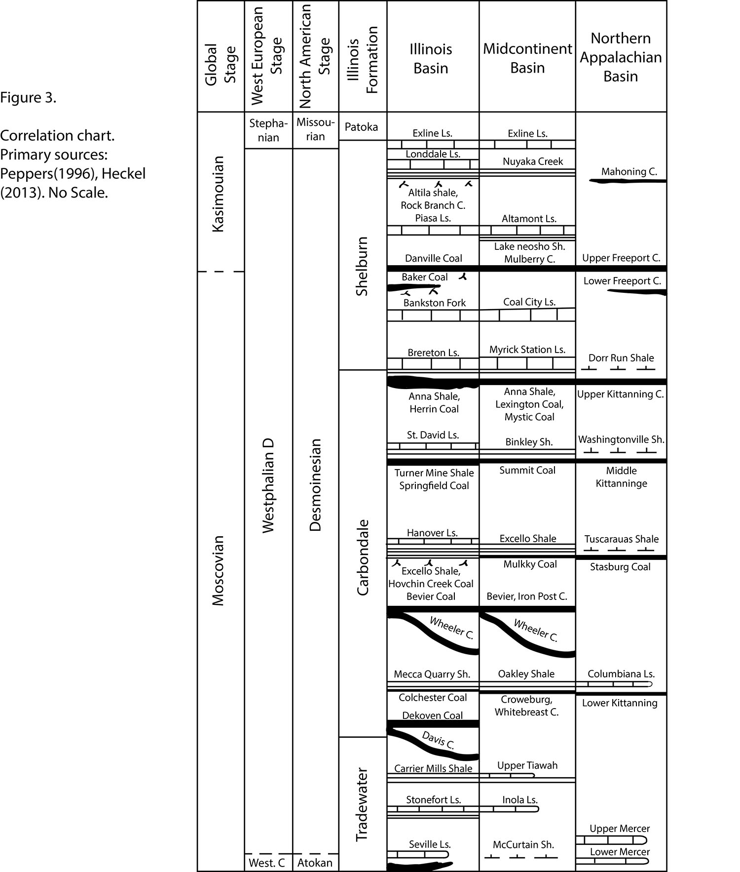
| 17:06, 8 March 2016 | Penn carb fig3.jpg (file) |  |
905 KB | Jennifer.Obrad | Correlation chart. Primary sources: Peppers (1996), Hickel (2013). No Scale | 1 |
| 16:57, 8 March 2016 | Penn carb fig1.jpg (file) |  |
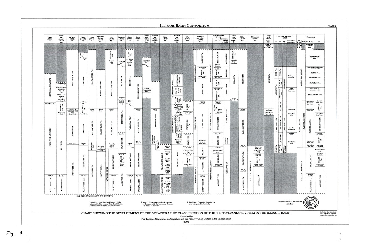
276 KB | Jennifer.Obrad | Chart Showing the Development of the Stratigraphic Classification of the Pennsylvanian System in the Illinois Basin. Compiled by the Tri-State Committee on Correlation of the Pennsylvanian System in the Illinois Basion, 2001. | 1 |
| 14:04, 15 January 2016 | Penn symbol.png (file) |  |
16 KB | Jennifer.Obrad | Pennsylvanian Geo Unit Designation symbol | 1 |
| 13:45, 15 January 2016 | Cambrian symbol.png (file) |  |
16 KB | Jennifer.Obrad | Symbol Used for the Cambrian Geo Unit Designation | 1 |
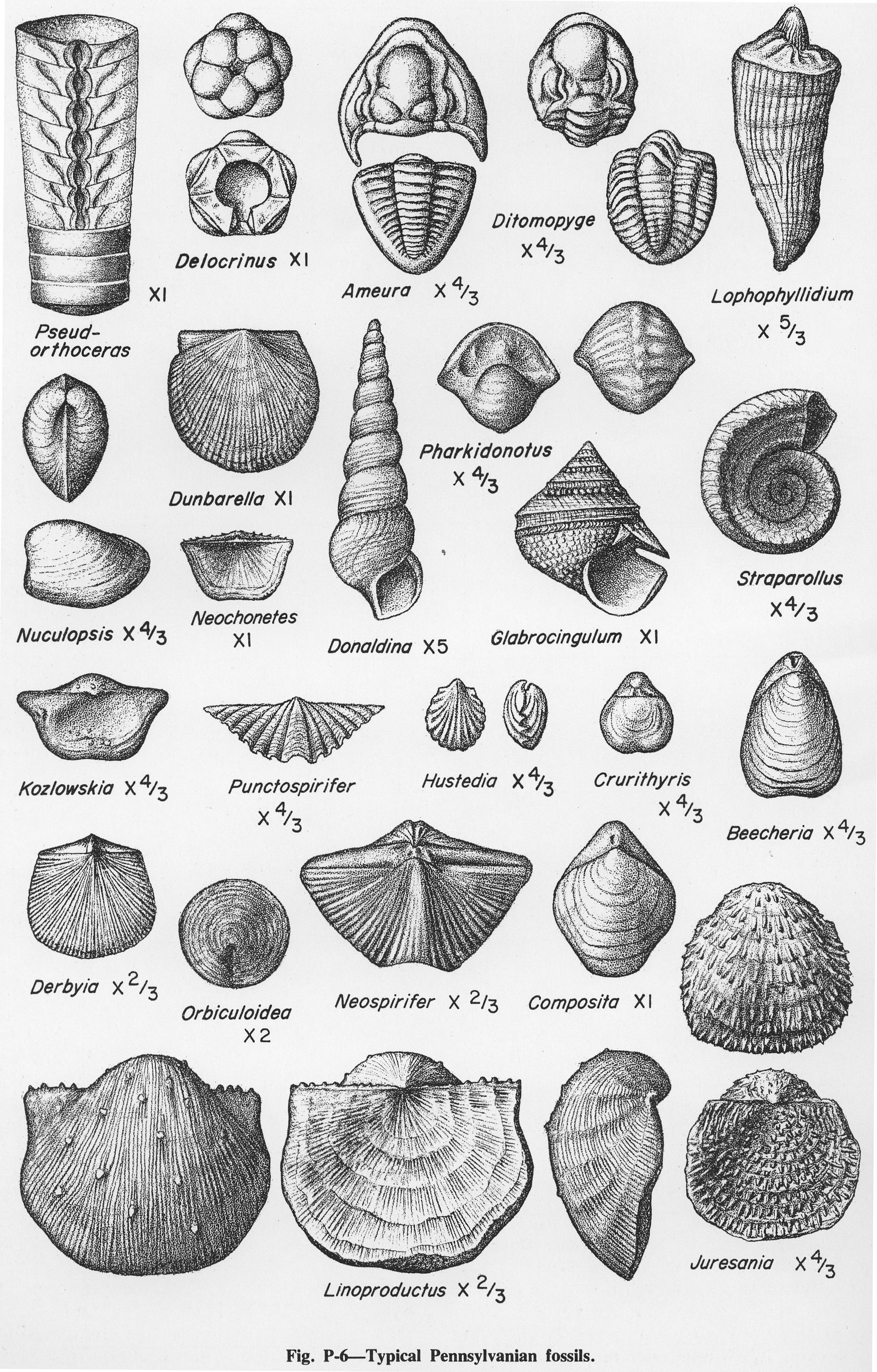
| 20:03, 14 October 2015 | Figure P-6.jpg (file) |  |
1.5 MB | Jennifer.Obrad | Fig. P-6 -- Typical Pennsylvanian fossils | 1 |
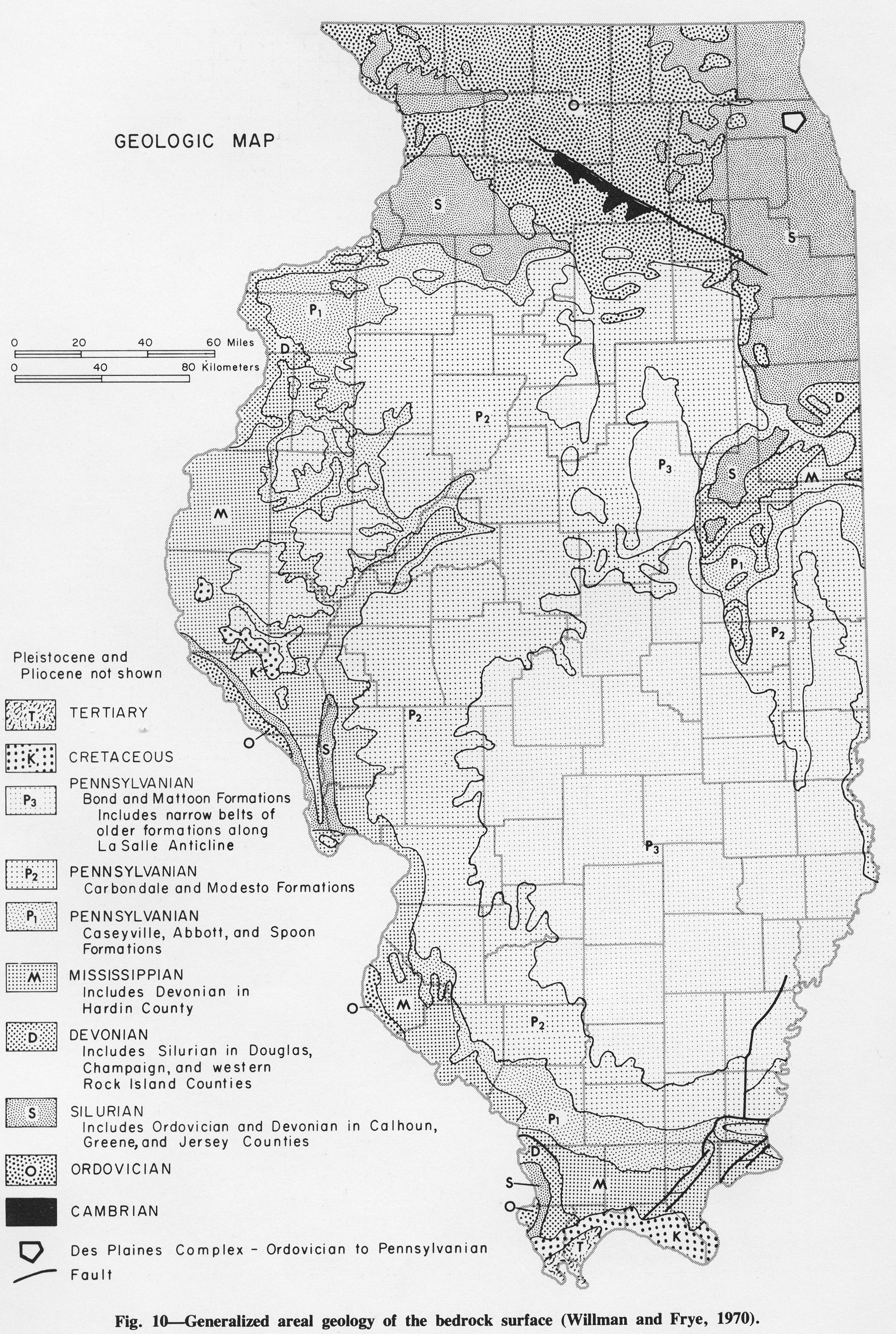
| 19:35, 14 October 2015 | Figure 10.jpg (file) |  |
1.61 MB | Jennifer.Obrad | Fig. 10 -- Generalized areal geology of the bedrock surface (Willman and Frye, 1970) | 1 |
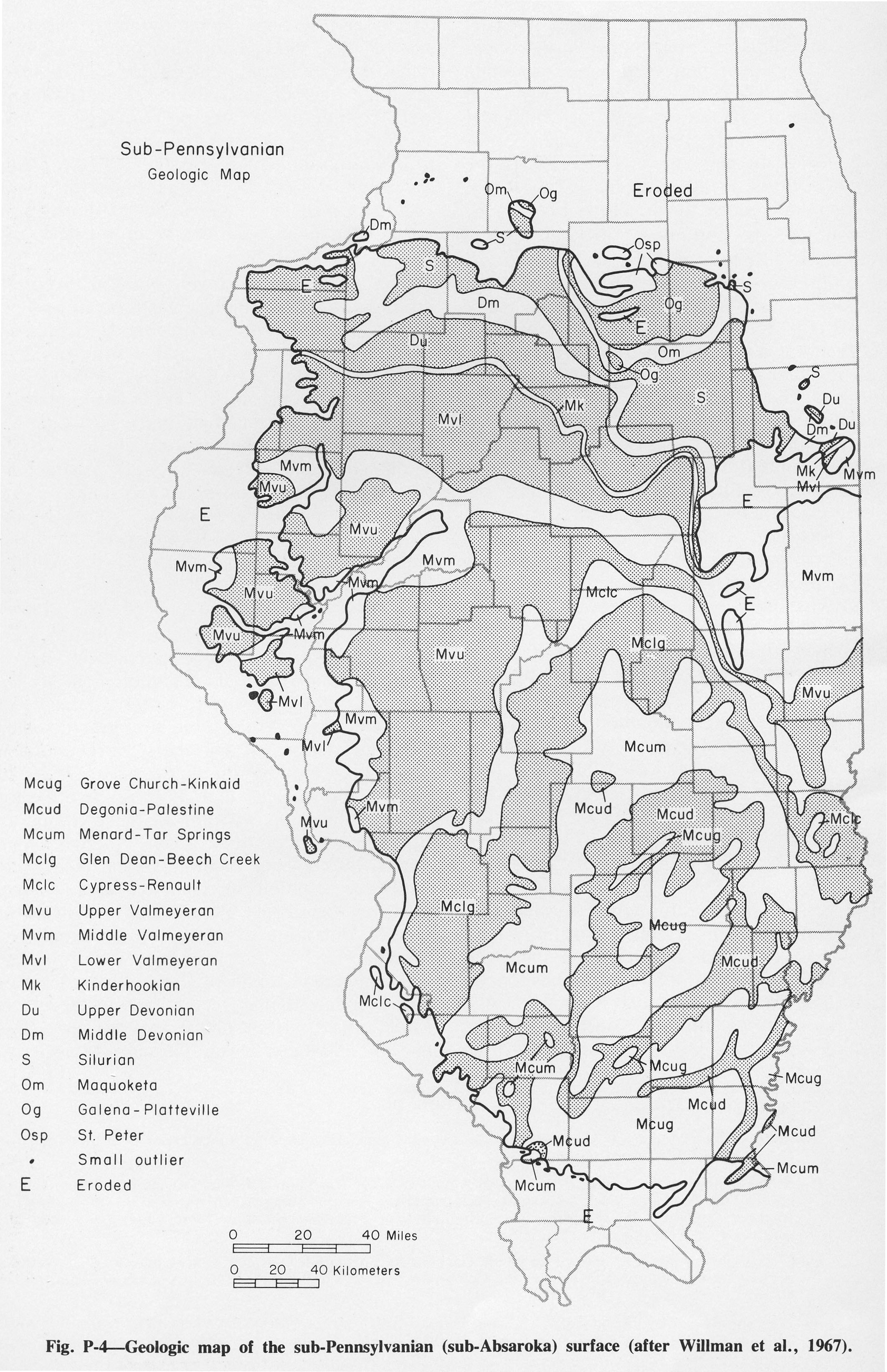
| 19:28, 14 October 2015 | Figure P-4.jpg (file) |  |
1.15 MB | Jennifer.Obrad | P-4 -- Geologic map of the sub-Pennsylvanian (sub-Absaroka) surface (after Willman et al., 1967) | 1 |
| 19:03, 14 October 2015 | Figure P-3C.jpg (file) |  |
1.41 MB | Jennifer.Obrad | P-3C -- Mecca Quarry Shale Member (M) of the Carbondale Formation in which a large limestone concretion is present (at the hammer), overlying the Colchester (No. 2) Coal Member (C) just south of Viola, Mercer County. | 1 |
| 18:40, 14 October 2015 | Figure P-3F.jpg (file) |  |
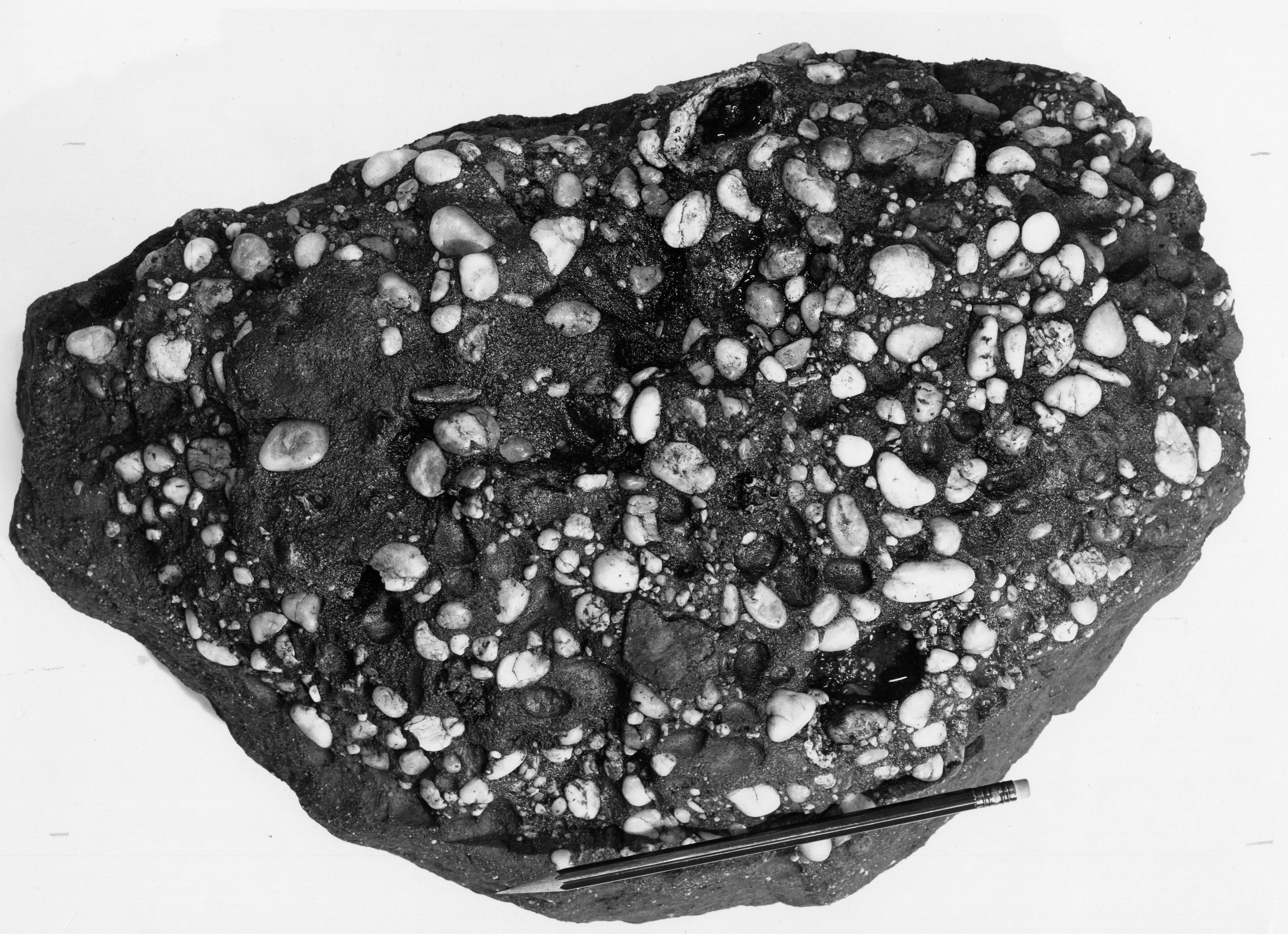
1.61 MB | Jennifer.Obrad | P-3F -- Quartz-pebble conglomerate in the Caseyville Formation near Shiloh Hill, Randolph County. | 1 |
| 18:39, 14 October 2015 | Figure P-3E.jpg (file) |  |
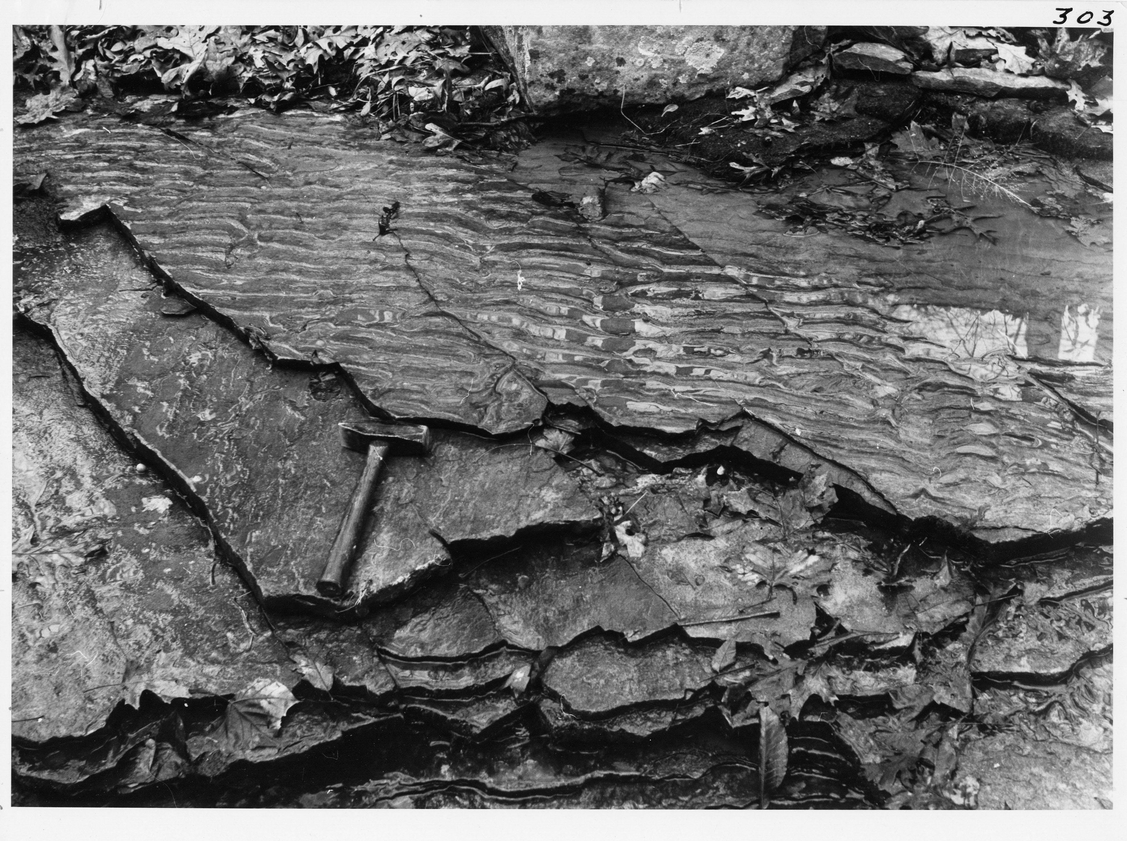
1.82 MB | Jennifer.Obrad | P-3E -- Asymmetrical current ripple marks and weak current laminations (parallel to hammer) in thin-bedded sandstone in the Caseyville Formation, near Pomona, Jackson County. | 1 |
| 18:35, 14 October 2015 | Figure P-3D.jpg (file) |  |
1.38 MB | Jennifer.Obrad | P-3D -- The Sub-Absaroka unconformity showing Pennsylvanian strata (Caseyville Formation) truncating Mississippian strata (Kinkaid Limestone) in a roadcut of U.S. Highway 51, north of Anna, Union County. | 1 |
| 18:30, 14 October 2015 | Figure P-3B.jpg (file) |  |
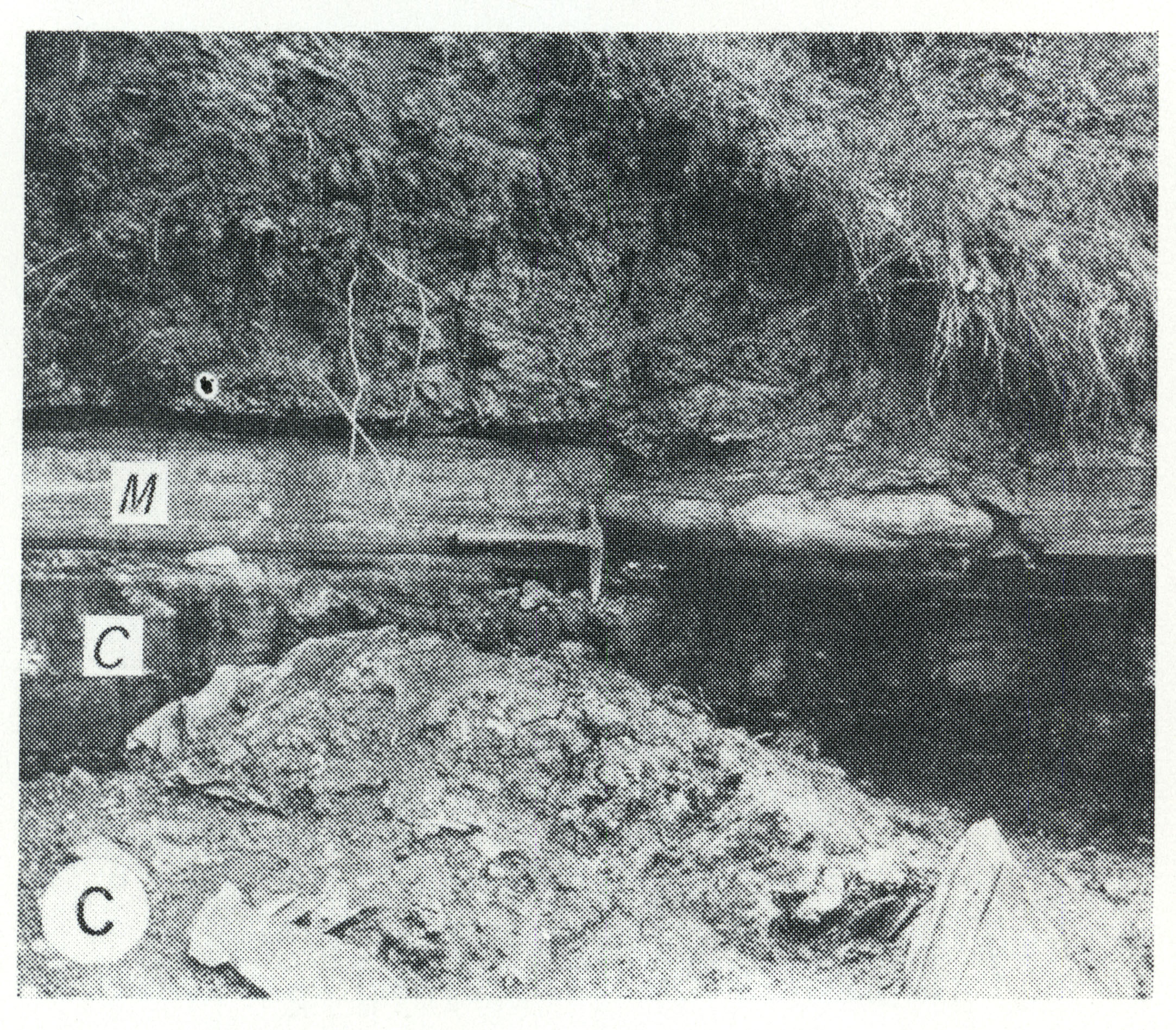
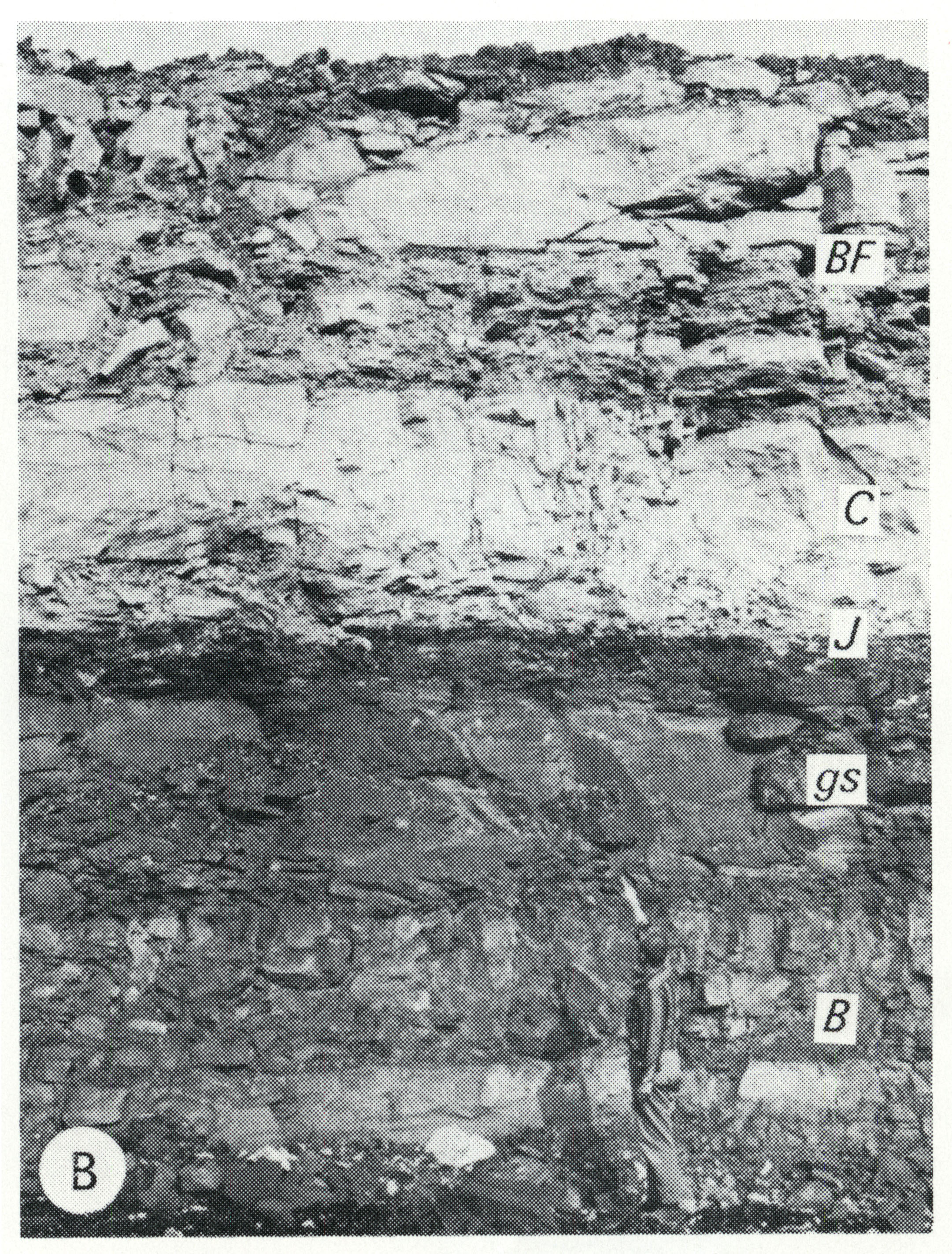
2.11 MB | Jennifer.Obrad | P-3B -- Strata overlying the Herrin (No. 6) Coal Member of the Carbondale Formation (at the man's feet), including the Bankston Fork Limestone Member (BF), Conant Limestone Member (C), Jamestown Coal Member (J, 1 inch thick), gray calcareous shale (gs)... | 1 |
| 16:24, 1 October 2015 | B104.jpg (file) |  |
29 KB | Jennifer.Obrad | 1 | |
| 16:15, 1 October 2015 | B94.jpg (file) |  |
18 KB | Jennifer.Obrad | 1 | |
| 19:38, 13 August 2015 | B95.jpg (file) |  |
20 KB | Alan.Myers | 1 | |
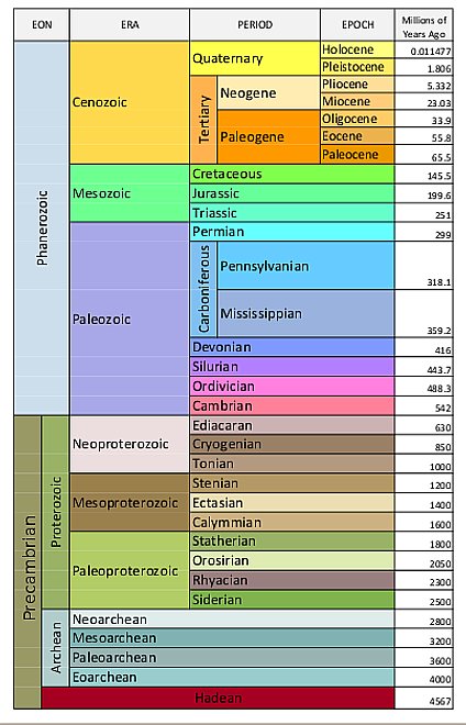
| 17:54, 10 August 2015 | Geologic-time-scale1.jpg (file) |  |
67 KB | Alan.Myers | 1 | |
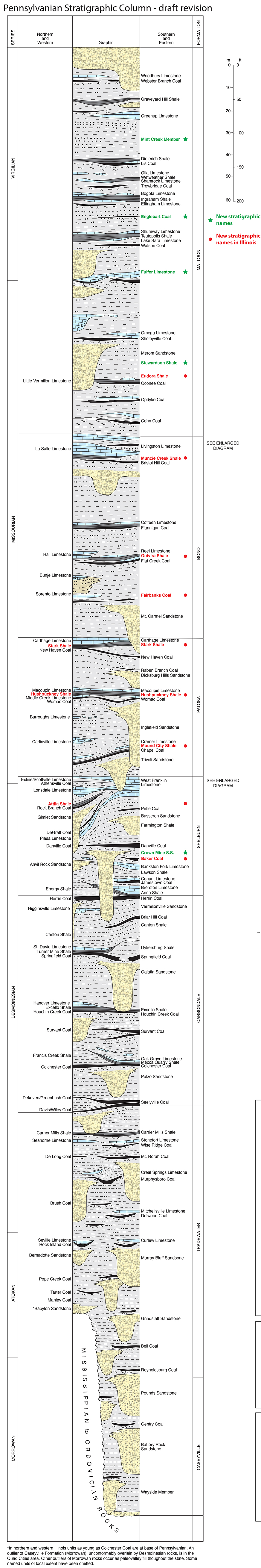
| 16:57, 10 August 2015 | Pennsylvanian column update.jpg (file) |  |
1.91 MB | Alan.Myers | 1 | |
| 16:12, 10 August 2015 | Pennsylvanian column.jpg (file) |  |
1.13 MB | Alan.Myers | Pennsylvanian Column test | 1 |
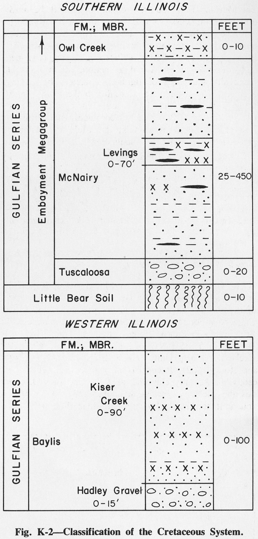
| 15:02, 6 August 2015 | Figure K-2.jpg (file) |  |
275 KB | Alan.Myers | Fig. K-2 -- Classification of the Cretaceous System | 1 |
| 20:09, 5 August 2015 | ISGS logo.jpg (file) | 178 KB | Alan.Myers | 1 | ||
| 14:43, 5 August 2015 | Figure P-5.jpg (file) |  |
684 KB | Alan.Myers | Fig. P-5 -- Development of Classification of the Pennsylvanian System) | 1 |
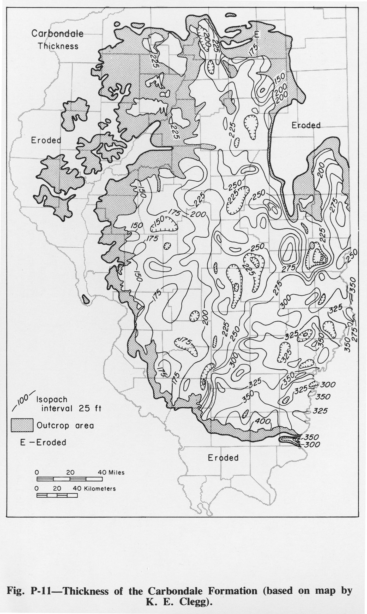
| 14:42, 5 August 2015 | Figure P-11.jpg (file) |  |
554 KB | Alan.Myers | Fig. P-11 -- Thickness of the Carbondale Formation (based on map by K.E. Clegg). | 1 |
| 14:41, 5 August 2015 | Figure P-12.jpg (file) |  |
640 KB | Alan.Myers | Fig. P-12 -- Thickness of the Harrisburg (No.5) and Springfield (No. 5) Coal Members (based on may by K.E. Glegg). | 1 |
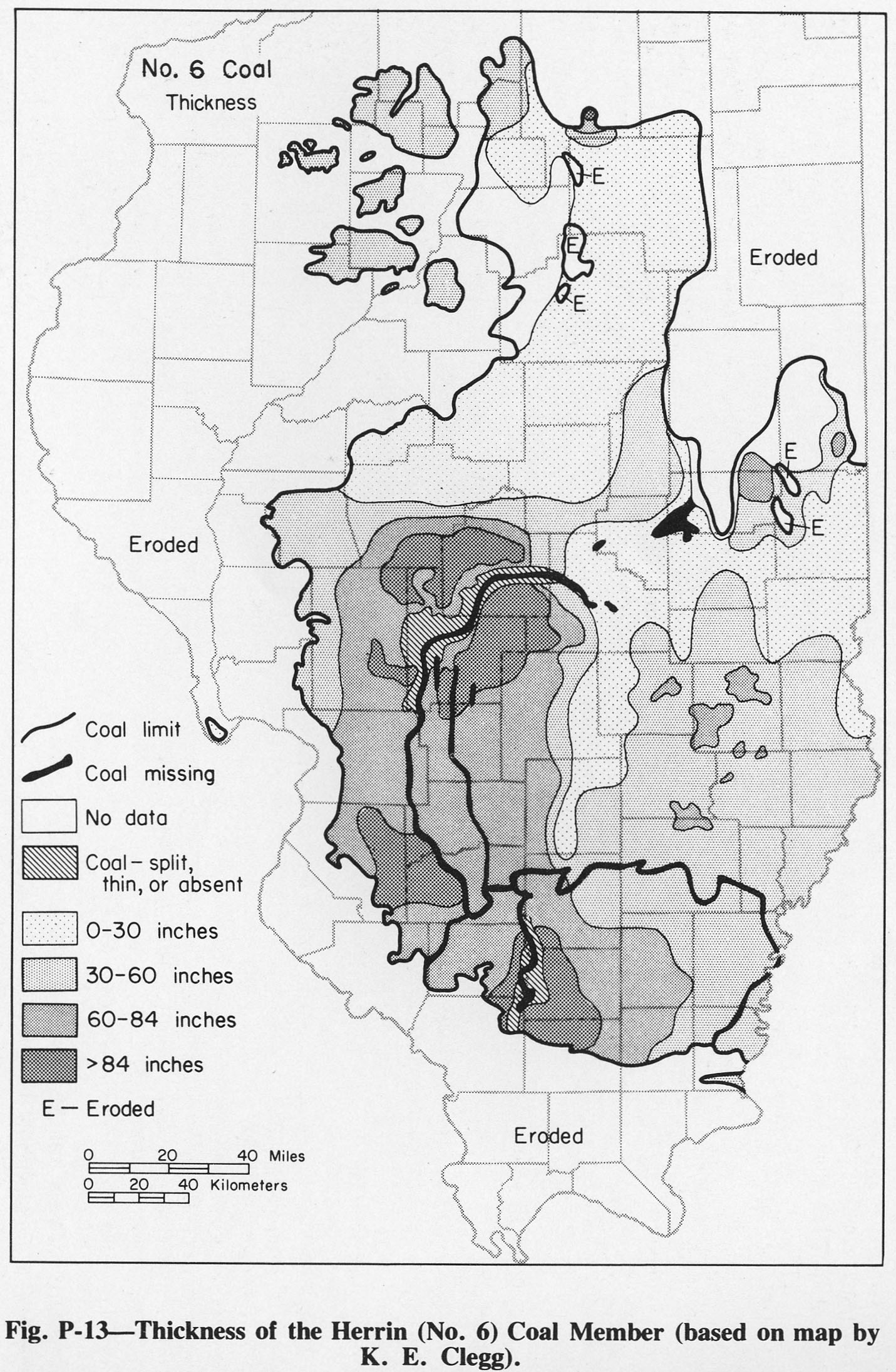
| 13:34, 5 August 2015 | Figure P-13.jpg (file) |  |
614 KB | Alan.Myers | Fig. P-13 -- Thickness of the Herrin (No. 6) Coal Member (based on map by K.R. Clegg) | 1 |