Semantic search
Jump to navigation
Jump to search
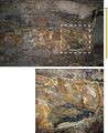 '''Figure 20''' Photographs showing the Springfield Coal “split” by massive siltstone in the Millennium Mine. The lower view is a close-up of the upper view. Notice the ragged splaying of coal layers into the siltstone from both above and below, with one coal stringer crossing diagonally from the lower to the upper coal “bench.” Combined with the absence of roots beneath the upper bench, such geometry implies that the upper part of the peat deposit was rafted. Enlarged view at right. Brown and yellow stains resulted from iron-rich water seeping through the coal.
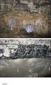 '''Figure 21''' Photographs of siltstone “splits” in the Springfield Coal. (a) Upper “bench” of coal splitting into multiple layers, with ragged splaying of lower coal layers at the Millennium Mine. (b) Contact between the upper coal bench and a massive siltstone split in American Coal’s Millennium Mine, approximately 0.6 mi (1 km) west of the main Galatia channel. Notice the complete absence of root traces in the siltstone.
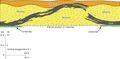 '''Figure 22''' Profile view of the disturbance in Figure 21a in the Millennium Mine, Saline County, Illinois.
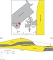 '''Figure 23''' Profile view of the disturbance Figure 21b in the Millennium Mine. The map shows the relationship to the Galatia channel.
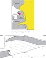 '''Figure 24''' Map and cross section of the disturbance in the Sahara No. 20 Mine, Saline County, Illinois.
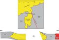 '''Figure 25''' Map and cross section of the disturbance in the Dering Coal Company No. 2 Mine, Saline County, Illinois. Redrafted from field sketches by Rolf Roley and G.H. Cady in the ISGS archives.
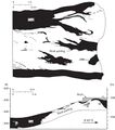 '''Figure 26''' Drawings from Meier and Harper (1981)'"`UNIQ--ref-00000001-QINU`"' illustrating a major disruption of the Springfield Coal in AMAX Coal’s Wabash Mine in Wabash County, Illinois.
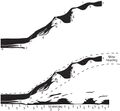 '''Figure 27''' (Top) Image of the major disturbance in the Wabash Mine. From Meier and Harper (1981). (Bottom) The same drawing with interpretation added, depicting the peat deposit torn asunder, with the upper part floated away from the lower. The seam height at the left side of the diagram is approximately 9 ft (2.7 m).
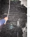 '''Figure 28''' Photograph of interlaminated carbonaceous shale and bright to dull coal close to the margin of the Sullivan channel in the Oaktown Mine in Knox County, Indiana.
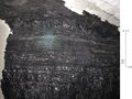 '''Figure 29''' Photograph of interlaminated carbonaceous shale and bright to dull coal close to the margin of the Sullivan channel in the Oaktown Mine in Knox County, Indiana.
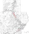 '''Figure 30''' Map from Potter (1962)'"`UNIQ--ref-00000001-QINU`"' showing the Effingham channel as described in this report.
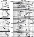 '''Figure 31''' Gamma-ray–neutron log from the Berry Petroleum No. 11-14 Pitcher well in Jasper County, Illinois, indicating coal in the upper part of the Effingham channel fill.
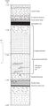 '''Figure 32''' Graphic log of core from Richland County, Illinois, showing filling of the Effingham channel. The core shows two upward-fining sequences, the lower having tidal rhythmites in the upper part. The borehole is ISGS No. 1 Elysium (Hazel Farm) in sec. 27, T4N, R9E (county no. 25922).
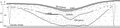 '''Figure 33''' Interpretive cross section of the Effingham channel in Richland County, Illinois, showing two stages of infilling, with local coal at the top of the lower stage.
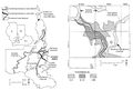 '''Figure 34''' Maps of the Leslie Cemetery channel. (a) Regional map showing the relationship to other channels. (b) Map of the northern part of the Leslie Cemetery channel, with the thickness of the Folsomville Member. From Eggert (1984), The Leslie Cemetery and Francisco distributary fluvial channels in the Petersburg Formation (Pennsylvanian) of Gibson County, Indiana, U.S.A., in R.A. Rahmani and R.M. Flores, eds., Sedimentology of coal and coal-bearing sequences: International Association of Sedimentologists, Special Publication 7 p. 311, 313. Copyright © 1984 The International Association of Sedimentologists.
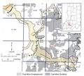 '''Figure 35''' Map of the Leslie Cemetery channel prepared for this study, using information from boreholes and mines. Lines of section for Figure 36 and Plate 6 are shown.
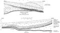 '''Figure 36''' Generalized sketches illustrating opposite margins of the Leslie Cemetery channel, as exposed in surface mines in the eastern half of 9S, 4W, Warrick County, Indiana. The upper image is from Peabody’s Lynnville Mine in July 1983, representing the northern half of the channel. The lower image is from Peabody’s Eby Pit in June 1982, representing the southern half of the channel.
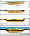 '''Figure 37''' Interpretive diagram showing sequential development of the Leslie Cemetery channel. (a) The Francisco channel is eroded and filled with sediment, largely sand. (b) Springfield peat accumulates in swale left by the abandoned channel. (c) Flowing water reoccupies the channel during the later stages of peat accumulation. Peat encroaches from the margins as the channel migrates laterally. (d) A marine incursion drowns the region and deposits black shale and limestone. Channel filling inverts the topography because of differential compaction.
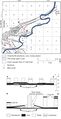 '''Figure 38''' Map and cross section of the Terre Haute channel. From Friedman (1960)'"`UNIQ--ref-00000001-QINU`"'. Courtesy of the Indiana Geological and Water Survey. Lines of cross section are shown on the map.
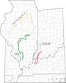 '''Figure 39''' Map of the Illinois Basin showing channels and gray shale wedges affecting the Murphysboro, Colchester, Herrin, Baker, and Danville Coals.


