Semantic search
Jump to navigation
Jump to search
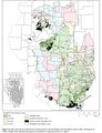 '''Figure 10''' Map showing the thickness and mined areas of the Springfield Coal throughout Illinois. After Treworgy et al. (1999)'"`UNIQ--ref-00000001-QINU`"'. Straight lines separating polygons are artifacts of mapping protocol in original.
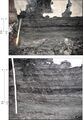 '''Figure 11''' Photographs showing thinly interlaminated shale and dull to bright coal along margins of the Galatia channel at the Prosperity Mine in Gibson County, Indiana. The lower frame is a closer view of the upper. The ruler is graduated in 0.1-ft intervals.
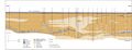 '''Figure 12''' Cross section of Galatia channel in American Coal’s Galatia Mine in Saline County, Illinois, based on core drilling and observations in mine.
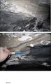 '''Figure 13''' Photographs showing the ragged, erosive contact between the light-colored siltstone of the Dykersburg Member and the underlying coaly shale of the Galatia Member in the channel crossing at the Galatia Mine, Saline County, Illinois. (a) View of the east wall of the entry. Coaly shale of the Galatia Member grades laterally northward (left, out of view) to shaly Springfield Coal. The pick is approximately 2 ft (60 cm) long. (b) Close-up view on the west wall of the entry. The heart of the Galatia channel is south (left) of view. Notice how erosion undercut the clay below layers of tough, fibrous peat.
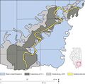 '''Figure 14''' Map showing the thickness of the Dykersburg Member in the vicinity of Galatia channel in southeastern Illinois. From Treworgy et al. (1999)'"`UNIQ--ref-00000001-QINU`"'.
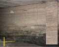 '''Figure 15''' Photograph showing rhythmic lamination in sandy facies of the Dykersburg Member in American Coal’s Millennium Mine, Saline County, Illinois. Enlarged view at right. Reprinted from Palaeogeography, Palaeoclimatology, Palaeoecology, v. 487, p. 74, W.A. DiMichele, S.D. Elrick, and W.J. Nelson, Vegetational zonation in a swamp forest, Middle Pennsylvanian, Illinois Basin, U.S.A., indicates niche differentiation in a wetland plant community. Copyright 2017, with permission from Elsevier.
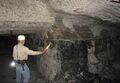 '''Figure 16''' Photograph showing rhythmic lamination in sandy facies of the Dykersburg Member in the Millennium Mine, with lamination offlapping the top of the coal. Sediment thus was deposited in a wedge, prograding from left to right.
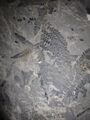 '''Figure 17''' Photographs showing large, well-preserved fronds of fossil plant foliage (Laevenopteris?) in the Dykersburg Member at Millennium Mine, Saline County, Illinois.
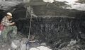 '''Figure 18''' Photograph of an upright tree stump, rooted at the top of the coal and encased in mudstone of the Dykersburg Member, at American Coal’s Galatia Mine in Saline County, Illinois.
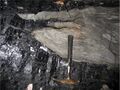 '''Figure 19''' Photograph of “rolls” at the top of the Springfield Coal, filled with Dykersburg sediments, at American Coal’s Millennium Mine in Saline County, Illinois. Ragged splaying of coal layers at the margins of rolls evokes fibrous peat layers ripped out by strong currents.
 '''Figure 20''' Photographs showing the Springfield Coal “split” by massive siltstone in the Millennium Mine. The lower view is a close-up of the upper view. Notice the ragged splaying of coal layers into the siltstone from both above and below, with one coal stringer crossing diagonally from the lower to the upper coal “bench.” Combined with the absence of roots beneath the upper bench, such geometry implies that the upper part of the peat deposit was rafted. Enlarged view at right. Brown and yellow stains resulted from iron-rich water seeping through the coal.
 '''Figure 21''' Photographs of siltstone “splits” in the Springfield Coal. (a) Upper “bench” of coal splitting into multiple layers, with ragged splaying of lower coal layers at the Millennium Mine. (b) Contact between the upper coal bench and a massive siltstone split in American Coal’s Millennium Mine, approximately 0.6 mi (1 km) west of the main Galatia channel. Notice the complete absence of root traces in the siltstone.
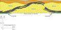 '''Figure 22''' Profile view of the disturbance in Figure 21a in the Millennium Mine, Saline County, Illinois.
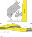 '''Figure 23''' Profile view of the disturbance Figure 21b in the Millennium Mine. The map shows the relationship to the Galatia channel.
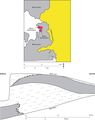 '''Figure 24''' Map and cross section of the disturbance in the Sahara No. 20 Mine, Saline County, Illinois.
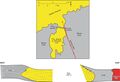 '''Figure 25''' Map and cross section of the disturbance in the Dering Coal Company No. 2 Mine, Saline County, Illinois. Redrafted from field sketches by Rolf Roley and G.H. Cady in the ISGS archives.
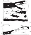 '''Figure 26''' Drawings from Meier and Harper (1981)'"`UNIQ--ref-00000001-QINU`"' illustrating a major disruption of the Springfield Coal in AMAX Coal’s Wabash Mine in Wabash County, Illinois.
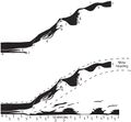 '''Figure 27''' (Top) Image of the major disturbance in the Wabash Mine. From Meier and Harper (1981). (Bottom) The same drawing with interpretation added, depicting the peat deposit torn asunder, with the upper part floated away from the lower. The seam height at the left side of the diagram is approximately 9 ft (2.7 m).
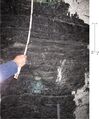 '''Figure 28''' Photograph of interlaminated carbonaceous shale and bright to dull coal close to the margin of the Sullivan channel in the Oaktown Mine in Knox County, Indiana.
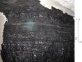 '''Figure 29''' Photograph of interlaminated carbonaceous shale and bright to dull coal close to the margin of the Sullivan channel in the Oaktown Mine in Knox County, Indiana.


