Shakopee Dolomite
Lithostratigraphy: Knox Dolomite Megagroup >>Prairie du Chien Group >>Shakopee Dolomite
Chronostratigraphy: Paleozoic Erathem >>Ordovician System >>Canadian Series >>Trempealeauan Stage
Allostratigraphy: Sauk Sequence
Primary source
Willman, H. B., Elwood Atherton, T. C. Buschbach, Charles Collinson, John C. Frye, M. E. Hopkins, Jerry A. Lineback, and Jack A. Simon, 1975, Handbook of Illinois Stratigraphy: Illinois State Geological Survey Bulletin 95, 261 p.
Contributing author(s)
H. B. Willman and T. C. Buschbach
Name
Original description
Shakopee Dolomite (Winchell, 1874, p. 138-139).
Derivation
Named for outcrops at Shakopee, Scott County, Minnesota.
Other names
History/background
Type section
Type location
Type author(s)
Type status
Reference section
Reference location
Reference author(s)
Reference status
Stratigraphic relationships
The Shakopee Dolomite overlies the New Richmond Sandstone or, where the New Richmond is absent, the Oneota Dolomite. It underlies the St. Peter Sandstone or, in southern Illinois, the Everton Dolomite.
Extent and thickness
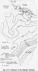
The Shakopee is exposed in Illinois along the Illinois River and its tributaries, from La Salle east to Utica, La Salle County; along the Fox River near Sheridan and Millington in La Salle and Kendall Counties; and along the Rock River and its tributaries between Franklin Grove, Lee County, and a point 2.5 miles west of Oregon, Ogle County (Willman and Templeton, 1951). It also occurs along the Mississippi River bluffs in Calhoun County in a small exposure on the crest of the Lincoln Anticline. The Shakopee is present throughout much of Illinois (fig. O-11), but in the northern two tiers of counties it has been extensively removed by pre-St. Peter solution and erosion, and in north-central Illinois it is eroded from parts of the Ashton Arch and the Oregon Anticline near the Sandwich Fault Zone. Closely spaced wells in the northern half of the state show irregularities of 50-100 feet in the thickness of the Shakopee. It thickens regularly southward and reaches almost 600 feet at a line drawn between Edgar and Monroe Counties. South of that line the Shakopee is not separated from the underlying carbonates with confidence, but it appears that the Shakopee, chiefly by the addition of younger beds at its top, reaches a thickness exceeding 2000 feet near the southern tip of Illinois.
Lithology
The Shakopee consists of argillaceous to pure, very fine-grained dolomite with some thin beds of medium-grained, cross-bedded sandstone, medium-grained dolomite, green to light gray shale, and buff siltstone. The dolomite is light gray to light brown, with the brown increasing toward the deep part of the Illinois Basin. It contains oolitic, partly sandy chert in discontinuous bands and isolated nodules. Some beds of the Shakopee are brecciated or conglomeratic. Bedding surfaces show ripple marks and mud cracks. Several layers of bentonite are present in a quarry 2.5 miles west of Oregon (Willman and Templeton, 1951).
Core(s)
Photograph(s)
Contacts
Well log characteristics
Fossils
Fossils are not abundant; those reported are chiefly gastropods and cephalopods. However, algal stromatolites are common in mats and domes that range from a few inches to more than 10 feet thick.
Age and correlation
Along the Mississippi River bluffs in Calhoun County in a small exposure on the crest of the Lincoln Anticline, the Shakopee Dolomite has been correlated with the Cotter (?) Dolomite (Rubey, 1952), but the Everton Dolomite has recently been traced to the adjacent area in Missouri, making it possible that the small Illinois outcrop may belong to the Everton. The Shakopee is equivalent to the Jefferson City and Cotter Dolomites of Missouri, and to the south it may include strata equivalent to the younger Powell and Smithville-Black Rock Formations.
Environments of deposition
Economic importance
Remarks
References
RUBEY, W. W., 1952, Geology and mineral resources of the Hardin and Brussels Quadrangles: USGS Professional Paper 218, 179 p.
WILLMAN, H. B., and J. S. TEMPLETON, 1951, Cambrian and Lower Ordovician exposures in northern Illinois: Illinois Academy of Science Transactions, v. 44, p. 109-125; Illinois State Geological Survey Circular 179, 1952.
WINCHELL, N. H., 1874, Second annual report for the year 1873: Minnesota Geological and Natural History Survey, p. 73-219.
ISGS Codes
| Stratigraphic Code | Geo Unit Designation |
|---|---|
