Sellers Limestone Bed: Difference between revisions
m (IlLex moved page Sellers Limestone Member to Sellers Limestone Bed without leaving a redirect) |
mNo edit summary |
||
| Line 1: | Line 1: | ||
__NOTOC__ | |||
{{Tree | {{Tree | ||
|category1=Paleozoic Erathem | |category1=Paleozoic Erathem | ||
|category2=Pennsylvanian Subsystem | |category2=Pennsylvanian Subsystem | ||
|category3=Absaroka Sequence | |category3=Absaroka Sequence | ||
|category4= | |category4=Raccoon Creek Group | ||
|category5=Morrowan Series | |category5=Morrowan Series | ||
|category6=Caseyville Formation | |category6=Caseyville Formation | ||
|category7=Limestone | |category7=Limestone | ||
|tree1= | |tree1=Raccoon Creek Group | ||
|tree2=Caseyville Formation | |tree2=Caseyville Formation | ||
|tree3=Sellers Limestone Member | |tree3=Sellers Limestone Member | ||
| Line 17: | Line 17: | ||
}} | }} | ||
==Primary source== | ==Primary source== | ||
Nelson, W.J., 2018, Pennsylvanian Subsystem in Illinois. Edited and figures drafted by Jennifer M. Obrad. Illinois State Geological Survey Bulletin (in press). | |||
==Contributing author(s)== | ==Contributing author(s)== | ||
W.J. Nelson | |||
==Name== | ==Name== | ||
===Original description=== | ===Original description=== | ||
Cox (1875, p. 205) was the first to describe “blue argillaceous shales, with numerous bands of carbonate of iron” containing marine invertebrate fossils, exposed along the Ohio River 0.5 mi (0.8 km) below Sellers’ paper mill. Wanless (1939, p. 36, 101) was apparently the first to use the name “Sellers limestone.” | |||
===Derivation=== | ===Derivation=== | ||
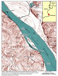
The name refers to the vanished community of Sellers Landing on the Ohio River in Hardin County, Illinois (Figure 2-1). G. Eschol Sellers settled here in 1850 and operated a paper mill, coal mines, and a shipping terminal on the river (Sneed 1977). Cox (1875, p. 205, footnote) mentioned walking out some of the outcrops in the company of G.E. Sellers. | |||
<center> | |||
{| class="wikitable" style="text-align: center;" | |||
|- | |||
|<gallery caption="" widths=250px heights=250px perrow=4> | |||
Penn_caseyville_2-1.jpg|{{file:Penn_caseyville_2-1.jpg}} | |||
</gallery> | |||
|} | |||
</center> | |||
===Other names=== | ===Other names=== | ||
None. | |||
===History/background=== | ===History/background=== | ||
The Sellers locality was long known as one of the few sites where marine fossils could be found in the Caseyville. Until 1960, geologists referred loosely and informally to the Sellers limestone or marine zone. Seeking to formalize all Pennsylvanian nomenclature in Illinois, Kosanke et al. (1960) designated this the Sellers Limestone Member of the Caseyville Formation. However, given that the Sellers Limestone has never been identified away from its type locality, the rank of the unit is hereby reduced to Sellers Limestone Bed. | |||
==Type section== | ==Type section== | ||
===Type location=== | ===Type location=== | ||
The type section is on the west | The type section is on the west bluff of the Ohio River about 0.5 mi (0.8 km) south of Sellers Landing in the SE¼ NE¼ SE¼ of Sec. 21, T11S, R10E, Hardin County, on the Dekoven 7.5-minute quadrangle. Various geologists have provided slightly different coordinates. Those given by H.R. Wanless in field notes dated 1938 appear to be the most accurate. | ||
===Type author(s)=== | ===Type author(s)=== | ||
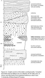
Given that the stratotype is the only known exposure, all the authors cited here described aspects of the section. A composite section (Figure 2-6) represents my attempt to consolidate the various published and unpublished descriptions. | |||
<center> | |||
{| class="wikitable" style="text-align: center;" | |||
|- | |||
|<gallery caption="" widths=250px heights=250px perrow=4> | |||
Penn_caseyville_2-6.jpg|{{file:Penn_caseyville_2-6.jpg}} | |||
</gallery> | |||
|} | |||
</center> | |||
===Type status=== | ===Type status=== | ||
Not verified. | |||
==Reference section== | ==Reference section== | ||
No exposures other than the type are known to exist. | |||
== | ==Stratigraphic relationships== | ||
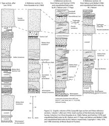
As shown in the Caseyville type section by Lee (1916), the Sellers Limestone is roughly midway between the [[Pounds Sandstone Member|Pounds]] and [[Battery Rock Sandstone Member|Battery Rock]] Sandstones and is above the [[Gentry Coal Bed|Gentry Coal]] (formerly Battery Rock coal) (Figure 2-2, column 1). A more detailed composite section assembled from published text and unpublished field notes places the Sellers in the lower part of an upward-coarsening sequence approximately 70 to 80 ft (21 to 24 m) thick (Figure 2-6). At least two thin, unnamed coal seams and the associated underclay are at the base of the sequence. The limestone itself changes dramatically across a small gully on the bluff face. On the north side, the limestone forms a channel-shaped deposit and is at least 8 ft (2.4 m) thick. South of the gully, the Sellers is reduced to thin, tabular limestone and ironstone layers within dark gray shale. | |||
== | <center> | ||
{| class="wikitable" style="text-align: center;" | |||
=== | |- | ||
|<gallery caption="" widths=250px heights=250px perrow=4> | |||
Penn_caseyville_2-2.jpg|{{file:Penn_caseyville_2-2.jpg}} | |||
</gallery> | |||
|} | |||
</center> | |||
==Extent and thickness== | ==Extent and thickness== | ||
The Sellers Limestone is known only at the type locality, where about | The Sellers Limestone is known only at the type locality, where the thickness ranges from about 2 to 13 ft (0.6 to 3.9 m), including limestone and interbedded shale (Figure 2-6). | ||
==Lithology== | ==Lithology== | ||
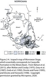
The most detailed description is that of Fraunfelter (1979), who indicated that the unit varies from a ledge of limestone about 8 ft (2.4 m) thick to a 10-ft (3.1-m) interval of gray shale having numerous thin interbeds of limestone and calcareous siltstone. Where the limestone is an 8-ft (2.4-m) ledge, it is medium gray, silty biomicrite (wackestone), slightly argillaceous and fossiliferous, “with randomly distributed whole to partly broken fossils or lenses of worn and broken fossils” (Figure 2-4, p. 75). Where the Sellers is mostly shale, the limestone beds are a few inches thick, medium to dark bluish-gray biomicrite (lime mudstone) containing “whole or partly broken, randomly distributed marine fossils or lenses of fossil ‘hash’” (Figure 2-4, p. 75). Near the top of the interval, the carbonates grade to calcareous siltstone lacking fossils. | |||
<center> | |||
{| class="wikitable" style="text-align: center;" | |||
|- | |||
|<gallery caption="" widths=250px heights=250px perrow=4> | |||
Penn_caseyville_2-4.jpg|{{file:Penn_caseyville_2-4.jpg}} | |||
</gallery> | |||
|} | |||
</center> | |||
==Core(s)== | ==Core(s)== | ||
| Line 64: | Line 100: | ||
==Contacts== | ==Contacts== | ||
As described, the contacts vary from sharp to gradational and show rapid lateral variation. | |||
==Well log characteristics== | ==Well log characteristics== | ||
No boreholes are known to penetrate this unit. | |||
==Fossils== | ==Fossils== | ||
Cox (1875) reported brachiopods, pelecypods, gastropods, and corals. Wanless (1939, p. 36) remarked that the Sellers yielded “nearly 100 species of marine invertebrates.” Unfortunately, no faunal list is known to exist. Fraunfelter (1979) observed gastropods, trilobites, pelecypods, blastoids, and shark’s teeth. Rexroad and Merrill (1985) described a conodont fauna. | |||
==Age and correlation== | ==Age and correlation== | ||
Rexroad and Merrill (1985, p. 49) are the only authors who brought fossil evidence to bear on correlation of the Sellers. They observed “evolutionary continuity” in conodonts from the Grove Church Member of the Kinkaid Formation (Mississippian) through several outcrops of the [[Wayside Member]] in Johnson and Union Counties, Illinois, to the Sellers Limestone, representing the most advanced forms. These authors did not discuss correlations outside southern Illinois or place any units into a regional chronostratigraphic framework. Many advances have been made in Pennsylvanian conodont biostratigraphy since 1985, so the potential exists for more precise regional and global correlation of the Sellers. | |||
==Environments of deposition== | ==Environments of deposition== | ||
The relationships depicted in the composite section (Figure 2-6) suggest that the Sellers is an estuarine deposit resulting from marine flooding of an incised valley. The cross-bedded sandstone near the base of the section may be lowstand fluvial sediment topped by soil horizons and thin peat layers. Upon transgression, the valley was flooded sufficiently to permit carbonate precipitation and a diverse marine fauna. The carbonates were then buried by progressively coarser clastic sediment as the estuary was backfilled. | |||
==Economic importance== | ==Economic importance== | ||
None. | |||
==Remarks== | ==Remarks== | ||
==References== | ==References== | ||
* Cox, E.T., 1875, Geology of Gallatin County: Geological Survey of Illinois, v. 6, p. 197–219.<br> | |||
* Fraunfelter, G.H., 1979, Lower Pennsylvanian limestones in the Illinois Basin, in J.E. Palmer, and R.R. Dutcher, eds., Depositional and structural history of the Pennsylvanian System of the Illinois Basin, Part 2: Invited papers: Illinois State Geological Survey, Field Trip 9/Ninth International Congress of Carboniferous Stratigraphy and Geology, Guidebook 15A, p. 73–75.<br> | |||
* Kosanke, R.M., J.A. Simon, H.R. Wanless, and H.B. Willman, 1960, Classification of the Pennsylvanian strata of Illinois: Illinois State Geological Survey, Report of Investigations 214, 84 p., 1 pl.<br> | |||
* Lee, W., 1916, Geology of the Shawneetown Quadrangle in Kentucky: Kentucky Geological Survey, Ser. 4, v. 4, part 2, 73 p.<br> | |||
* Rexroad, C.B., and G.K. Merrill, 1985, Conodont biostratigraphy and paleoecology of Middle Carboniferous rocks in southern Illinois: Frankfurt-am-Main, Germany, Courier Forschunginstitut Senckenberg, v. 74, p. 35–64.<br> | |||
* Sneed, G.J., 1977, Ghost towns of southern Illinois: Royalton, Illinois, G.J. Sneed, 309 p.<br> | |||
* Wanless, H.R., 1939, Pennsylvanian correlations in the Eastern Interior and Appalachian coal fields: Geological Society of America, Special Paper 17, 130 p., 9 pls.<br> | |||
{{Codes | {{Codes | ||
Revision as of 21:51, 23 July 2018
Lithostratigraphy: Raccoon Creek Group >>Caseyville Formation >>Sellers Limestone Member
Chronostratigraphy: Paleozoic Erathem >>Pennsylvanian Subsystem >>Morrowan Series
Allostratigraphy: Absaroka Sequence
Primary source
Nelson, W.J., 2018, Pennsylvanian Subsystem in Illinois. Edited and figures drafted by Jennifer M. Obrad. Illinois State Geological Survey Bulletin (in press).
Contributing author(s)
W.J. Nelson
Name
Original description
Cox (1875, p. 205) was the first to describe “blue argillaceous shales, with numerous bands of carbonate of iron” containing marine invertebrate fossils, exposed along the Ohio River 0.5 mi (0.8 km) below Sellers’ paper mill. Wanless (1939, p. 36, 101) was apparently the first to use the name “Sellers limestone.”
Derivation
The name refers to the vanished community of Sellers Landing on the Ohio River in Hardin County, Illinois (Figure 2-1). G. Eschol Sellers settled here in 1850 and operated a paper mill, coal mines, and a shipping terminal on the river (Sneed 1977). Cox (1875, p. 205, footnote) mentioned walking out some of the outcrops in the company of G.E. Sellers.
Other names
None.
History/background
The Sellers locality was long known as one of the few sites where marine fossils could be found in the Caseyville. Until 1960, geologists referred loosely and informally to the Sellers limestone or marine zone. Seeking to formalize all Pennsylvanian nomenclature in Illinois, Kosanke et al. (1960) designated this the Sellers Limestone Member of the Caseyville Formation. However, given that the Sellers Limestone has never been identified away from its type locality, the rank of the unit is hereby reduced to Sellers Limestone Bed.
Type section
Type location
The type section is on the west bluff of the Ohio River about 0.5 mi (0.8 km) south of Sellers Landing in the SE¼ NE¼ SE¼ of Sec. 21, T11S, R10E, Hardin County, on the Dekoven 7.5-minute quadrangle. Various geologists have provided slightly different coordinates. Those given by H.R. Wanless in field notes dated 1938 appear to be the most accurate.
Type author(s)
Given that the stratotype is the only known exposure, all the authors cited here described aspects of the section. A composite section (Figure 2-6) represents my attempt to consolidate the various published and unpublished descriptions.
Type status
Not verified.
Reference section
No exposures other than the type are known to exist.
Stratigraphic relationships
As shown in the Caseyville type section by Lee (1916), the Sellers Limestone is roughly midway between the Pounds and Battery Rock Sandstones and is above the Gentry Coal (formerly Battery Rock coal) (Figure 2-2, column 1). A more detailed composite section assembled from published text and unpublished field notes places the Sellers in the lower part of an upward-coarsening sequence approximately 70 to 80 ft (21 to 24 m) thick (Figure 2-6). At least two thin, unnamed coal seams and the associated underclay are at the base of the sequence. The limestone itself changes dramatically across a small gully on the bluff face. On the north side, the limestone forms a channel-shaped deposit and is at least 8 ft (2.4 m) thick. South of the gully, the Sellers is reduced to thin, tabular limestone and ironstone layers within dark gray shale.
|
Extent and thickness
The Sellers Limestone is known only at the type locality, where the thickness ranges from about 2 to 13 ft (0.6 to 3.9 m), including limestone and interbedded shale (Figure 2-6).
Lithology
The most detailed description is that of Fraunfelter (1979), who indicated that the unit varies from a ledge of limestone about 8 ft (2.4 m) thick to a 10-ft (3.1-m) interval of gray shale having numerous thin interbeds of limestone and calcareous siltstone. Where the limestone is an 8-ft (2.4-m) ledge, it is medium gray, silty biomicrite (wackestone), slightly argillaceous and fossiliferous, “with randomly distributed whole to partly broken fossils or lenses of worn and broken fossils” (Figure 2-4, p. 75). Where the Sellers is mostly shale, the limestone beds are a few inches thick, medium to dark bluish-gray biomicrite (lime mudstone) containing “whole or partly broken, randomly distributed marine fossils or lenses of fossil ‘hash’” (Figure 2-4, p. 75). Near the top of the interval, the carbonates grade to calcareous siltstone lacking fossils.
|
Core(s)
Photograph(s)
Contacts
As described, the contacts vary from sharp to gradational and show rapid lateral variation.
Well log characteristics
No boreholes are known to penetrate this unit.
Fossils
Cox (1875) reported brachiopods, pelecypods, gastropods, and corals. Wanless (1939, p. 36) remarked that the Sellers yielded “nearly 100 species of marine invertebrates.” Unfortunately, no faunal list is known to exist. Fraunfelter (1979) observed gastropods, trilobites, pelecypods, blastoids, and shark’s teeth. Rexroad and Merrill (1985) described a conodont fauna.
Age and correlation
Rexroad and Merrill (1985, p. 49) are the only authors who brought fossil evidence to bear on correlation of the Sellers. They observed “evolutionary continuity” in conodonts from the Grove Church Member of the Kinkaid Formation (Mississippian) through several outcrops of the Wayside Member in Johnson and Union Counties, Illinois, to the Sellers Limestone, representing the most advanced forms. These authors did not discuss correlations outside southern Illinois or place any units into a regional chronostratigraphic framework. Many advances have been made in Pennsylvanian conodont biostratigraphy since 1985, so the potential exists for more precise regional and global correlation of the Sellers.
Environments of deposition
The relationships depicted in the composite section (Figure 2-6) suggest that the Sellers is an estuarine deposit resulting from marine flooding of an incised valley. The cross-bedded sandstone near the base of the section may be lowstand fluvial sediment topped by soil horizons and thin peat layers. Upon transgression, the valley was flooded sufficiently to permit carbonate precipitation and a diverse marine fauna. The carbonates were then buried by progressively coarser clastic sediment as the estuary was backfilled.
Economic importance
None.
Remarks
References
- Cox, E.T., 1875, Geology of Gallatin County: Geological Survey of Illinois, v. 6, p. 197–219.
- Fraunfelter, G.H., 1979, Lower Pennsylvanian limestones in the Illinois Basin, in J.E. Palmer, and R.R. Dutcher, eds., Depositional and structural history of the Pennsylvanian System of the Illinois Basin, Part 2: Invited papers: Illinois State Geological Survey, Field Trip 9/Ninth International Congress of Carboniferous Stratigraphy and Geology, Guidebook 15A, p. 73–75.
- Kosanke, R.M., J.A. Simon, H.R. Wanless, and H.B. Willman, 1960, Classification of the Pennsylvanian strata of Illinois: Illinois State Geological Survey, Report of Investigations 214, 84 p., 1 pl.
- Lee, W., 1916, Geology of the Shawneetown Quadrangle in Kentucky: Kentucky Geological Survey, Ser. 4, v. 4, part 2, 73 p.
- Rexroad, C.B., and G.K. Merrill, 1985, Conodont biostratigraphy and paleoecology of Middle Carboniferous rocks in southern Illinois: Frankfurt-am-Main, Germany, Courier Forschunginstitut Senckenberg, v. 74, p. 35–64.
- Sneed, G.J., 1977, Ghost towns of southern Illinois: Royalton, Illinois, G.J. Sneed, 309 p.
- Wanless, H.R., 1939, Pennsylvanian correlations in the Eastern Interior and Appalachian coal fields: Geological Society of America, Special Paper 17, 130 p., 9 pls.
ISGS Codes
| Stratigraphic Code | Geo Unit Designation |
|---|---|


