Historical:Tuscaloosa Formation
Lithostratigraphy: Embayment Megagroup >>Tuscaloosa Formation
Chronostratigraphy: Mesozoic Erathem >>Cretaceous System >>Gulfian Series
Authors
H. B. Willman and John C. Frye
Name Origin
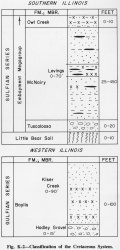
The Tuscaloosa Formation (Smith and Johnson, 1887, p. 18, 95-117) (fig. K-2), is named for exposures along the Tuscaloosa (Black Warrior) River near Tuscaloosa, Alabama.
Correlation
The Tuscaloosa in Illinois is similar in lithology and stratigraphic position to the Tuscaloosa of Kentucky and Tennessee, but it is a transgressive deposit and may be younger than the type Tuscaloosa.
Extent and Thickness
It is exposed only locally in extreme southern Illinois and appears to have a patchy distribution (Pryor, 1960; Pryor and Ross, 1962; Ross, 1964). It has maximum thickness of 20 feet but is generally much thinner. The Tuscaloosa is well exposed along the Post Creek Cutoff, Pulaski County (cen. 2, 15S-2E), and in railroad cuts in the Thebes Gorge, 1 mile south of Rock Springs Hollow, Alexander County (SW 21, 15S-3W).
Description
It is largely chert gravel, generally moderately cemented with fine silica or white clay. The chert pebbles, in a matrix of coarse quartz sand, are mainly white or gray, but black pebbles are locally common. Beds of pebbly sand and white clay also are common. The clays are dominantly kaolinite (Pryor and Glass, 1961). The Little Bear Soil occurs in deposits at the base of the Tuscaloosa Formation. Gravel found northeast of Elco in northern Alexander County (SW SE 7, 14S-1W) is probably Tuscaloosa Gravel preserved in sink holes. Local concentrations of gray and black chert pebbles on the upland bedrock surfaces as far north as Kaolin, Union County (SW NW 2, 12S-2W), are probably residual or reworked from the Tuscaloosa.
References
PRYOR, W. A., 1960, Cretaceous sedimentation in upper Mississippi Embayment: American Association of Petroleum Geologists Bulletin, v. 44, p. 1473-1504; Illinois State Geological Survey Reprint 1960-J.
PRYOR, W. A., and H. D. GLASS, 1961, Cretaceous-Tertiary clay mineralogy of the upper Mississippi Embayment: Journal of Sedimentary Petrology, v. 31, p. 36-51; Illinois State Geological Survey Reprint 1961-M.
PRYOR, W. A., and C. A. ROSS, 1962, Geology of the Illinois parts of the Cairo, La Center, and Thebes Quadrangles: Illinois State Geological Survey Circular 332, 39 p.
ROSS, C. A., 1964, Geology of the Paducah and Smithland Quadrangles in Illinois: Illinois State Geological Survey Circular 360, 32 p.
SMITH, E. A., and L. C. JOHNSON, 1887, Tertiary and Cretaceous strata of the Tuscaloosa, Tombigbee, and Alabama Rivers: USGS Bulletin 43, 189 p.
ISGS Codes
| Stratigraphic Code | Geo Unit Designation |
|---|---|

