Historical:Sugar Run Formation
Lithostratigraphy: Hunton Limestone Megagroup >>Sugar Run Formation
Chronostratigraphy: Paleozoic Erathem >>Silurian System >>Niagaran Series
Allostratigraphy: Tippecanoe Sequence
Authors
H. B. Willman and Elwood Atherton
Name Origin
The Sugar Run Formation (Willman, 1973, p. 22) is named for Sugar Run, a stream on the south side of Joliet, Will County, along which it is well exposed.
Type Section
The type section, just south of the stream, is in the National Stone Company quarry, which is also the location of the type section for the Joliet Formation. The lower 26 feet of the Sugar Run is exposed at the top of the east face of the quarry.
Other Names
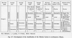
The Sugar Run strata, informally called the "building stone beds, " were originally included with overlying interreef Racine strata in the Waukesha Formation (Savage, 1926), but later the Waukesha was restricted to the lower beds (Willman, 1943) (fig. S-7); recently Waukesha was replaced with Sugar Run (Willman, 1973).
Extent and Thickness
The Sugar Run Formation is about 30 feet thick in the Joliet area and its contact with the overlying Racine Formation is exposed on the north side of Joliet, particularly where State Highway 4A ascends the east bluff of the Des Plaines Valley (NW NW SE 34, 36N-10E). The Sugar Run Formation is exposed along the Des Plaines River from Joliet to Sag Bridge, in quarries at Elmhurst and Hillside, along the Du Page River at Naperville, along the Fox River Valley at Aurora and Batavia, and along the Kankakee River from Rock Creek Canyon to Wiley Creek. It is absent in subsurface in some areas, in which it may be laterally equivalent to interreef strata included in the Racine Formation.
Stratigraphic Position
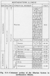
The Sugar Run Formation (Willman, 1973, p. 22) overlies the Joliet Formation in northeastern Illinois (fig. S-3).
Description
The Sugar Run is slightly to moderately argillaceous and silty, very fine-grained, dense to slightly vesicular, light greenish gray, buff-weathering dolomite that occurs in medium to thick smooth-surfaced beds. It has been extensively quarried for building stone. Rock from quarries near Lemont was called "Athens Marble" and that from Joliet was called "Joliet Marble." The basal 7 feet of the Sugar Run grades uniformly into the pure Romeo Member of the Joliet Formation below.
Fossils
The Sugar Run generally has few macrofossils, but trilobites, particularly Calymene, are found in the Lemont area and elsewhere, and a varied fauna has been described (Lowenstam, 1948a).
References
LOWENSTAM, H. A., 1948a, Biostratigraphic studies of the Niagaran inter-reef formations in northeastern Illinois: Illinois State Museum Science Papers, v. 4, 146 p.
WILLMAN, H. B., 1943, High-purity dolomite in Illinois: Illinois State Geological Survey Report of Investigations 90, 89 p.
WILLMAN, H. B., 1973, Rock stratigraphy of the Silurian System in northeastern and northwestern Illinois: Illinois State Geological Survey Circular 479, 55 p.
ISGS Codes
| Stratigraphic Code | Geo Unit Designation |
|---|---|


