Historical:Sexton Creek Limestone
Lithostratigraphy: Hunton Limestone Megagroup >>Sexton Creek Limestone
Chronostratigraphy: Paleozoic Erathem >>Silurian System >>Alexandrian Series
Allostratigraphy: Tippecanoe Sequence
Authors
H. B. Willman and Elwood Atherton
Name Origin
The Sexton Creek Limestone named for exposures in the Mississippi River bluff at the mouth of Sexton Creek in Alexander County (SW 27, 14S-3W) where it is about 40 feet thick.
Type Section
The Sexton Creek Limestone is best exposed 4 miles northeast of Sexton Creek, just north of the mouth of Dongola Hollow (SW SE NW 12, 14S-3W).
Correlation
The formation is correlated with the Kankakee Formation in northern Illinois on the basis of its fossils, although the faunal zones that mark the top and bottom of the Kankakee Formation have not been found in the Sexton Creek. The Sexton Creek is approximately equivalent to the Brassfield Limestone in Indiana and Kentucky.
Stratigraphic Position
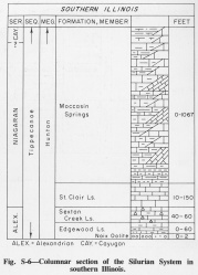
The Sexton Creek Limestone (Savage, 1909, p. 518; Ulrich, 1911) overlies the Edgewood Formation in southern Illinois (fig. S-6). The Sexton Creek was originally defined to include higher strata, now differentiated as the St. Clair Limestone, but was restricted to its present boundaries by Ulrich (1911). The Sexton Creek locally truncates the Edgewood Limestone to rest directly on the Girardeau Limestone. The Sexton Creek and its contact with the Edgewood Limestone are exposed in a roadcut a quarter of a mile southeast of Gale (NE NE NW 4, 15S-3W) (Pryor and Ross, 1962).
Description
The formation is a thin-bedded, fine-grained, cherty, gray limestone. The upper part is thicker bedded and is mottled red. In the areas where it is relatively thick, the Sexton Creek commonly contains persistent bands of black chert nodules.
References
PRYOR, W. A., and C. A. ROSS, 1962, Geology of the Illinois parts of the Cairo, La Center, and Thebes Quadrangles: Illinois State Geological Survey Circular 332, 39 p.
SAVAGE, T. E., 1909, Ordovician and Silurian formations in Alexander County, Illinois: American Journal of Science, v. 28, p. 509-519.
ULRICH, E. O., 1911, Revision of the Paleozoic systems: Geological Society of America Bulletin, v. 22, p. 281-680.
ISGS Codes
| Stratigraphic Code | Geo Unit Designation |
|---|---|

