Historical:Owl Creek Formation
Lithostratigraphy: Embayment Megagroup >>Owl Creek Formation
Chronostratigraphy: Mesozoic Erathem >>Cretaceous System >>Gulfian Series
Authors
H. B. Willman and John C. Frye
Name Origin
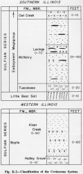
The Owl Creek Formation (Hilgard, 1860) (fig. K-2), named for exposures along Owl Creek, 3 miles northeast of Ripley, Tippah County, Mississippi, is the uppermost Cretaceous Formation in southern Illinois.
Extent and Thickness
The Owl Creek Formation is exposed in Illinois only in Pulaski County along the Ohio River near U.S. Dam 53 (SE NW NE 13, 15S-1E) and along the Cache River near Unity (NE 7, S 1/2 6, 16S-1W) (Pryor and Ross, 1962). It is 0-10 feet thick.
Stratigraphic Position
The Owl Creek overlies the McNairy Formation Formation conformably. A weathered zone at its top, marked by concentrations of hematitic nodules and a sharp upper contact, indicates an unconformity that separates the Owl Creek from the overlying Tertiary Clayton Formation.
Description
It consists of glauconitic, very micaceous, sandy, silty clay and silt.
Depositional Environment
The Owl Creek indicates a brief advance of the sea over the McNairy delta.
References
HILGARD, E. W., 1860, Report on the geology and agriculture of the State of Mississippi: Jackson, Mississippi, p.79. 84-91, 102.
PRYOR, W. A., and C. A. ROSS, 1962, Geology of the Illinois parts of the Cairo, La Center, and Thebes Quadrangles: Illinois State Geological Survey Circular 332, 39 p.
ISGS Codes
| Stratigraphic Code | Geo Unit Designation |
|---|---|

