Historical:Downeys Bluff Limestone
Lithostratigraphy: Pope Megagroup >>Paint Creek Group >>Cedar Bluff Limestone Group >>Downeys Bluff Limestone
Chronostratigraphy: Paleozoic Erathem >>Mississippian Subsystem >>Chesterian Series >>Gasperian Stage
Allostratigraphy: Kaskaskia Sequence
Authors
Elwood Atherton, Charles Collinson, and Jerry A. Lineback
Name Origin
The Downeys Bluff Limestone (Atherton, 1947, p. 129) is named for Downeys Bluff, Hardin County.
Type Section
The type section for the Downeys Bluff Limestone is in a bluff along the Ohio River (NW SE 5, 13S-8E).
Extent and Thickness
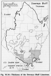
The Downeys Bluff generally is 20-30 feet thick in Gallatin, Saline, and parts of Jackson and adjacent counties (fig. M-34), where it consists of two limestone benches separated by a thin shale. Elsewhere the Downeys Bluff consists of only the upper of the two benches, generally 5-10 feet thick but locally 10-20 feet thick.
Stratigraphic Position
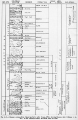
The Downeys Bluff was originally regarded as a member of the Paint Creek Formation in southwestern Illinois and of the Renault Formation in southeastern Illinois, but it was later traced across the Illinois Basin (Dana and Scobey, 1941). It is now a formation at the base of the Paint Creek Group in southwestern Illinois and at the top of the Cedar Bluff Group in southeastern Illinois (fig. M-25).
Description
Where two benches of the Downeys Bluff are present, the upper is typically cherty and the lower is slightly silty or very finely sandy. Limestone of the Downeys Bluff is white or light brownish gray and crinoidal. Many crinoid segments are replaced by pink chert. The pink crinoids are an excellent diagnostic characteristic that is better developed in the western than in the eastern part of Illinois.
References
ATHERTON, ELWOOD, 1947, Some Chester outcrop and subsurface sections in southeastern Illinois: Illinois Academy of Science Transactions., v. 40, p. 122-131; 1948, Illinois State Geological Survey Circular 144.
DANA, P. L., and E. H. SCOBEY, 1941, Cross section of Chester of Illinois Basin: American Association of Petroleum Geologists Bulletin, v. 25, p. 871-882.
ISGS Codes
| Stratigraphic Code | Geo Unit Designation |
|---|---|


