Historical:Delavan Member
Lithostratigraphy: Wedron Group >>Tiskilwa Formation >>Delavan Member
Chronostratigraphy: Cenozoic Erathem >>Quaternary System >>Pleistocene Series
Authors
Ardith K. Hansel and W. Hilton Johnson
Name
Original description
Delavan Till Member (Willman and Frye 1970).
Derivation
Delavan, a village in Tazewell County, central Illinois.
History/background
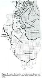
The Delavan Till Member was originally defined by Willman and Frye (1970); it was described as gray, silty, illitic till of the Peoria Sublobe area and up to 200 feet (61 m) thick in the Shelbyville Morainic System (fig. 13). In earlier reports diamicton of the Delavan Till Member was often referred to as Shelbyville till or drift (e. g., Frye et al. 1962).
|
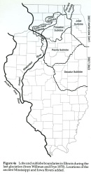
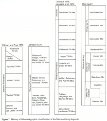
In 1970, Willman and Frye did not subdivide the Wedron Formation into members in the Decatur Sublobe area (fig. 4), but in the decade that followed six till members and one nontill member of the Wedron Formation were defined for that area (Johnson et al. 1971b, Ford 1973, Wickham 1979a). In 1976, Johnson correlated three of the till members of the Wedron Formation of the Decatur Sublobe area (the Glenburn, Oakland, and Fairgrange Till Members) with the Tiskilwa and Delavan Till Members of the Peoria Sublobe area. These three units formed a lower, medium textured group of Wedron tills (fig. 7).
The Glenburn Till Member was defined by Johnson et al. (1971b) as a brownish gray, loam till that oxidizes to a distinct brown or pink. It was defined in the Danville region, where it is primarily a subsurface unit. Although Johnson et al. (1971b) believed it to be part of the Woodfordian Substage and to correlate with subsurface Woodfordian tills to the west (Kempton et al. 1971), a radiocarbon age of 38,000 years for wood from near the base of the unit left its age equivocal.
The Fairgrange Till Member was defined by Ford in 1973 and described as an olive brown to light brownish gray, loam till that is sometimes pinkish; its type locality is in the Charleston Stone Quarry pits. Ford (1973) suggested the Fairgrange Till Member correlated with the Tiskilwa Till Member in McLean County and the Glenburn Till Member in Vermilion County (fig. 5). Correlation of the Fairgrange Till Member with the Glenburn Till Member was considered uncertain because of the 38,000 radiocarbon age for the wood in basal Glenburn till.
The Oakland Till Member was also defined by Ford (1973). It was described as a brown to brownish gray, loam to silt loam till relatively abundant in expandable clay minerals, probably as a result of the incorporation of weathered material from the Robein Member of the Roxana Silt. Ford (1973) correlated the Oakland Till Member from its type locality in northeastern Coles County with unit 5 of Kempton et al. (1971) in McLean County and with the basal Wedron Formation till in the Danville area (Johnson et al. 1972).
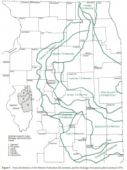
On the state map of Quaternary deposits (Lineback 1979; fig. 5), the Fairgrange Till Member was mapped as the Decatur Sublobe-equivalent of the Tiskilwa and Delavan Till Members. The Oakland and Glenburn Till Members and the Ashmore Member were not mapped; all are subsurface units. The Glenburn was correlated with the Fairgrange Till Member at the surface (Ford 1973).
In this report, the concept of the Delavan Member is broadened to include the former Oakland, Fairgrange, and Glenburn Till Members. These three members are dropped as formal lithostratigraphic units, although the Oakland is retained as a lower brown, silty facies of the Delavan Till Member or the undivided Tiskilwa Formation. The Oakland facies contains more expandable clay minerals. The Fairgrange Till Member is dropped because (1) no lithologic change has been documented across the Delavan-Fairgrange Till Member boundary as shown on the Quaternary map (Lineback 1979; fig. 5), (2) no significant lithologic difference exists between the diamicton units mapped as the Fairgrange Till Member on either side of the area mapped as the Piatt Till Member, and (3) the Fairgrange Till Member is in the same stratigraphic position as the Delavan Till Member. Thereby, the classification system is simplified, and the Delavan Member, which takes precedence over the more recently defined members, is extended to the Decatur Sublobe area.
Type section
Roadcuts along Illinois Highway 121, 4 miles (6.4 km) east of Delavan. No longer exposed.
Reference section
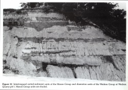
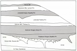
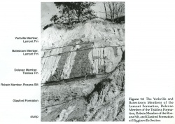
Danvers Section; good for boundaries and lithology. Farm Creek Section; good for lower boundary and lithology. Wedron Section (fig. 12) and Higginsville Section (fig. 14); good for boundaries and lithology.
Stratigraphic relationships
The Delavan Member consists of the lower gray to brown or violet gray loam diamicton beds of the Tiskilwa Formation. Locally the Delavan Member is pinkish and similar to the undivided Tiskilwa Formation. Diamicton of the Delavan Member oxidizes to brown, yellow brown, or pink.
The Delavan Member is readily distinguishable from the underlying sorted sediment of the Morton, Ashmore, and Peddicord Tongues, and the Robein Member. Although the Oakland facies of the Delavan Member and the undivided Tiskilwa Formation may be similar mineralogically and texturally to the Robein Member, the Oakland facies has a different structure and does not contain a weathering profile. In portions of the Peoria and Decatur Sublobe areas, diamicton lithology changes laterally along moraines, and for this reason determining the upper boundary of the Delavan is problematic.
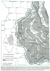
Kempton et al. (1971) mapped the distribution of till units in part of the Peoria Sublobe area on the basis of subsurface data, including color, clast lithology, and grain-size and clay-mineral analyses. They showed two families of tills and multiple till units, which they attributed to glacial overriding during successive events. Kempton et al. (1971) also recognized lateral and vertical variations in diamicton color and called for glacial incorporation of older units and shear stacking as a mechanism of moraine building. They concluded that the principal moraines were, in some cases, a composite of two or more till units and the surface till represented a veneer over older till units. In the area near Bloomington, their mapping suggested that the eastern portions of the LeRoy, Shirley, and Bloomington Moraines contain the younger Batestown Member of the Lemont Formation at the surface. Alternatively, some of the lateral and vertical changes in diamicton lithology may reflect facies changes within the same till unit. For this study, we chose the latter interpretation and use a vertical boundary at the front of the Bloomington Morainic System to separate the Delavan Member from the overlying undivided Tiskilwa Formation (fig. 13). Thus, the surface diamicton in the Shirley and LeRoy Moraines in the eastern part of the Peoria Sublobe area would be mapped as a facies of the Delavan that is siltier and more illitic than type Delavan. The diamicton of the Bloomington Morainic System would be mapped as a facies of the undivided Tiskilwa Formation that is grayer and finer grained than type Tiskilwa.
In the southern and western parts of the Decatur Sublobe area, the upper contact of the Delavan Member with the Piatt Member locally appears conformable and gradational over about a 0.5-meter (1.6 ft) zone; farther north in the up-ice direction, the boundary is lithologically distinct and sometimes marked by a striated clast pavement and/or sorted sediment. The western boundary of the Piatt Member (fig. 12) is taken from Lineback (1979; fig. 5). In the southeastern portion of the Decatur Sublobe area, lithologic distinction between the Delavan and Piatt Members (Tiskilwa Formation) and the Batestown Member (Lemont Formation) is difficult; therefore, for mapping and nomenclatural purposes, a vertical boundary at the front of the Cerro Gordo Moraine in Coles County is used to separate the Delavan and Piatt Members (fig. 13).
Extent and thickness
The Delavan Member forms a wedge-shaped deposit that pinches out beneath the undivided Tiskilwa Formation in the Harvard, Princeton, and the Peoria Sublobe areas and beneath the Piatt Member in the Decatur Sublobe area. It occurs at the surface in part of the Peoria and Decatur Sublobe areas (fig. 13). In thickness the Delavan Member varies from more than 60 meters (197 ft) in the Shelbyville Morainic System in the Peoria Sublobe area (Willman and Frye 1970) to less than 1 meter (3.3 ft) beneath the undivided Tiskilwa Formation in the northern part of the area. Ford (1973) reported an average thickness (Fairgrange Till Member) of 12 to 18 meters (39-59 ft) in Coles County in the Decatur Sublobe area.
Lithology
The Delavan Member consists of calcareous, brown gray to pink gray or violet gray, loam diamicton that contains lenses of gravel, sand, silt, and clay. Typically the diamicton oxidizes to brown, tan, yellow brown, or red brown.
Contacts
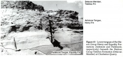
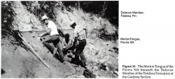
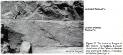
Lower boundary: the contact with the Ashmore Tongue (Henry Formation [figs. 12, 15]), the Peddicord Tongue (Equality Formation [figs. 12, 15]), the Morton Tongue (Peoria Silt [fig. 16]), the Robein Member (Roxana Silt [fig. 14]), or older units. Upper boundary: the contact with the Piatt Member (Tiskilwa Formation), the undivided Tiskilwa Formation (fig. 17), the Batestown Member (Lemont Formation), upper tongues of the Peoria Silt and the Henry and Equality Formations, or other surficial units.
Age and correlation
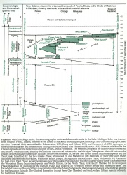
The Delavan Member was deposited during the early part of the Marengo Phase of the Michigan Subepisode in the Harvard and Princeton Sublobe areas and during the Shelby Phase in the Peoria and Decatur Sublobe areas, probably between about 26,000 and 18,500 radiocarbon years ago (Hansel and Johnson 1992; fig. 10). It likely correlates with a basal grayer facies of the undivided Tiskilwa Formation in some areas of Illinois.
|
Environments of deposition
Where it occurs at the surface in the Peoria and Decatur Sublobe areas, the Delavan Member is interpreted to be till and ice-marginal, redeposited sediment; its composition probably reflects predominantly a local source of glacial debris eroded from older drift and bedrock. In the area where it is buried beneath the undivided Tiskilwa Formation or the Piatt Member, the Delavan Member may constitute a lower, more locally derived till unit in the glacigenic sequence (Johnson and Hansel 1990).
Remarks
Reclassified unit. Name changed to the Delavan Member, unit classified as part of the Tiskilwa Formation, and unit description broadened to include lithologically similar and stratigraphically equivalent diamicton (Fairgrange, Oakland, and Glenburn Till Members of the Decatur Sublobe area). Formerly classified as the Delavan Till Member of the Wedron Formation (Willman and Frye 1970).
References
FORD, J., 1973, Surficial Deposits of Coles County, Illinois: Illinois State Geological Survey Open File Report, 73 p.
FRYE, J. C., H. D. GLASS, and H. B. WILLMAN, 1962, Stratigraphy and Mineralogy of the Wisconsinan Loesses of Illinois: Illinois State Geological Survey Circular 334, 55 p.
HANSEL, A. K., and W. H. JOHNSON, 1992, Fluctuations of the Lake Michigan Lobe during the late Wisconsin Subepisode: Sveriges Geologiska Undersokning, Series Ca 81, p. 133-144.
JOHNSON, W. H., 1976, Quaternary stratigraphy in Illinois—Status and current problems, in W. C. Mahaney, editor, Quaternary Stratigraphy of North America: Dowden, Hutchinson, & Ross, Inc., Stroudsburg, PA, p. 169-196.
JOHNSON, W. H., L. R. FOLLMER, D. L. GROSS, and A. M. JACOBS, 1972, Pleistocene Stratigraphy of East-Central Illinois: Illinois State Geological Survey Guidebook 9, 97 p.
JOHNSON, W. H., D. L. GROSS, and S. R. MORAN, 1971b, Till stratigraphy of the Danville region, east-central Illinois, in R. P. Goldthwait, J. L. Forsyth, D. L. Gross, and F. Pessl, Jr., editors, Till, A Symposium: Ohio State University Press, Columbus, p. 184-216.
JOHNSON, W. H., and A. K. HANSEL, 1990, Multiple Wisconsinan glacigenic sequences at Wedron, Illinois: Journal of Sedimentary Petrology, v. 60, no. 1, p. 26-41.
KEMPTON, J. P., P. B. DuMONTELLE, and H. D. GLASS, 1971, Subsurface stratigraphy of the Woodfordian tills in the McLean County region, Illinois, in R. P Goldthwait, J. L. Forsyth, D. L. Gross, and F. Pessl, Jr., editors, Till, A Symposium: Ohio State University Press, Columbus, p. 217-233.
LINEBACK, J. A., 1979, Quaternary Deposits of Illinois (Map): Illinois State Geological Survey, scale 1:500,000.
WICKHAM, J. T., 1979a, Glacial Geology of North-Central and Western Champaign County, Illinois: Illinois State Geological Survey Circular 506, 30 p.
WILLMAN, H. B., and J. C. FRYE, 1970, Pleistocene Stratigraphy of Illinois: Illinois State Geological Survey Bulletin 94, 204 p.
ISGS Codes
| Stratigraphic Code | Geo Unit Designation |
|---|---|
