Historical:Carbondale Formation
Lithostratigraphy: Kewanee Group >>Carbondale Formation
Chronostratigraphy: Paleozoic Erathem >>Pennsylvanian Subsystem >>Desmoinesian Series
Allostratigraphy: Absaroka Sequence
Authors
M. E. Hopkins and J. A. Simon
Name Origin
The Carbondale Formation of the Kewanee Group (Shaw and Savage, 1912, p. 6; Wanless, 1939, p. 79; Willman and Payne, 1942, p. 86-87; Kosanke et al., 1960, p. 34) is named for Carbondale, Jackson County, which lies near the outcrop belt of these rocks.
Type Section
A type section consisting of three outcrops was established in Fulton County, western Illinois (SE NE 1, 7N-4E; NW NE NW 20, 8N-3E; and SW cor. 21, 8N-3E) by Kosanke et al. (1960, p. 34, 46).
Correlation
The Carbondale Formation correlates with the upper portion of the Carbondale Formation and approximately the lower 50 feet of the Sturgis Formation in western Kentucky, where the boundaries are the base of the Kentucky No. 6 coal and the top of the Kentucky No. 11 coal. Essentially the same interval is called the Carbondale Group in Indiana.
Extent and Thickness
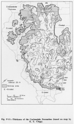
The formation varies from less than 150 feet in western and northeastern Illinois to more than 400 feet near its outcrop belt in southern Illinois.(fig. P-11) The Carbondale sandstones occur in elongate, channel facies up to about 100 feet thick and also in thinner sheets.
Definition
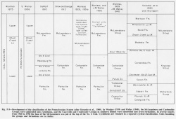
The Carbondale includes strata from the base of the Colchester (No. 2) Coal Member to the top of the Danville (No. 7) Coal Member (fig P-2). Shaw and Savage included in the Carbondale the strata from the base of the Murphysboro Coal to the top of the Herrin (No. 6) Coal. The Murphysboro was thought to be equivalent to the Colchester (No. 2) Coal of western Illinois, and the intent was to make the Colchester Coal the base of the formation. Wanless (1939) redefined the Carbondale as a group (fig. P-5), and Willman and Payne (1942) included strata from the base of the Palzo Sandstone to the base of the Anvil Rock Sandstone in the Carbondale Group.
Description
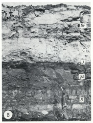
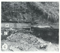
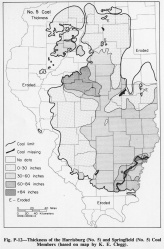
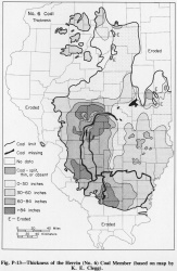
The Carbondale Formation consists of a large number of named members, many of which possess remarkable lateral persistence in thickness and lithologic character. In the sandstones and gray silty shales, however, rapid lateral changes are common and are primarily responsible for local and regional changes in thickness. Most of the sandstones are subgraywackes and are more argillaceous than older Pennsylvanian sandstones, although only slightly more so than sandstones of the Spoon Formation. Gray shales are the most abundant type of sediment in Carbondale rocks. Some contain only marine fossils and others only plant fossils. Most of the thicker gray shales probably are either delta front or pro-delta deposits. Sideritic nodules and bands are common, especially in the lower parts of the shales. The widespread limestones (fig. P-3B) are gray to dark gray, argillaceous, and normally fossiliferous. Associated with the marine limestones are extensive black fissile shales (fig. P-3C) that are generally less than 2 feet thick and contain marine fossils. Light gray nodular limestones, commonly without fossils, occur in the bottom part of the widespread underclays. The Carbondale Formation contains the principal economic coals of Illinois, the Herrin (No. 6) (fig. P-13) , the Springfield-Harrisburg (No. 5) (fig. P-12), the Colchester (No. 2), and the Danville (No. 7) Coal Members, in order of importance as reserves.
|
References
KOSANKE, R. M., J. A. SIMON, H. R. WANLESS, and H. B. WILLMAN, 1960, Classification of the Pennsylvanian strata of Illinois: Illinois State Geological Survey Report of Investigations 214, 84 p.
SHAW, E. W., and T. E. SAVAGE, 1912, Murphysboro and Herrin Quadrangles: USGS Geological Atlas Folio 185, 15 p.
WANLESS, H. R., 1939, Pennsylvanian correlations in the Eastern Interior and Appalachian coal fields: Geological Society of America Special Paper 17, 130 p.
WILLMAN, H. B., and J. N. PAYNE, 1942, Geology and mineral resources of the Marseilles, Ottawa, and Streator Quadrangles: Illinois State Geological Survey Bulletin 66, 388 p.
ISGS Codes
| Stratigraphic Code | Geo Unit Designation |
|---|---|
