Historical:Absaroka Sequence
Chronostratigraphy: Paleozoic Erathem >>Pennsylvanian Subsystem
Allostratigraphy: Absaroka Sequence
Authors
M. E. Hopkins and J. A. Simon
Name Origin
The Absaroka Sequence is named for the Absaroka Mountains in northwestern Wyoming and southern Montana.
Stratigraphic Position
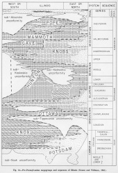
The major unconformity at the base of the Pennsylvanian System marks the base of the Absaroka Sequence (Sloss et al., 1949, p. 121) (fig. 14). In Illinois the sequence includes only the strata of the Pennsylvanian System, and its top is the major unconformity at the base of the Cretaceous System (Swann and Willman, 1961).
Description
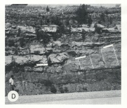
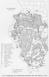
Clastic sediments -- shale, sandstone, and siltstone -- dominate the sequence. Minor unconformities consisting of deeply entrenched valley systems occur within the Absaroka, but many of the erosional channels in the sequence were produced by entrenchment of river distributaries in deltaic sediments. Except for minor sedimentational dips on local structures, the strata in the sequence are essentially parallel. In the Appalachian Basin and the Midcontinent areas, this sequence continues upward into the Permian System, but no Permian rocks have been found in Illinois. The basal unconformity separating the Absaroka from the underlying Kaskaskia Sequence (fig. P-3D) has been characterized (Siever, 1951; Wanless, 1955; Bristol and Howard, 1971) as an erosion surface formed by streams draining to the south and southeast in western Illinois and to the southwest in central and southern Illinois. The surface has local relief of as much as 450 feet and relatively steep-sided valleys. It truncates all the older Paleozoic systems except the Cambrian (fig. P-4).
References
BRISTOL, H. M., and R. H. HOWARD, 1971, Paleogeologic map of the sub-Pennsylvanian Chesterian (upper Mississippian) surface in the Illinois Basin: Illinois State Geological Survey Circular 458, 14 p.
SIEVER, RAYMOND, 1951, Mississippian-Pennsylvanian unconformity in southern Illinois: American Association of Petroleum Geologists Bulletin, v. 35, p. 542-581; Illinois State Geological Survey Report of Investigations 152.
SLOSS, L. L., W. C. KRUMBEIN, and E. C. DAPPLES, 1949, Integrated facies analysis, in Sedimentary facies in geologic history: Geological Society of America Memoir 39, p. 91-123.
SWANN, D. H., and H. B. WILLMAN, 1961, Megagroups in Illinois: American Association of Petroleum Geologists Bulletin, v. 45, p. 471-483; Illinois State Geological Survey Reprint 1961-N.
WANLESS, H. R., 1955, Pennsylvanian rocks of Eastern Interior Basin: American Association of Petroleum Geologists Bulletin, v. 39, p. 1753-1820 (see 1962).
WANLESS, H. R., 1962, Pennsylvanian rocks of Eastern Interior Basin, in Pennsylvanian System in the United States-- A symposium: American Association of Petroleum Geologists. Originally published 1955; reprinted with minor revisions.
WILLMAN, H. B., et al., 1967, Geologic map of Illinois: Illinois State Geological Survey.
ISGS Codes
| Stratigraphic Code | Geo Unit Designation |
|---|---|


