Hanover Limestone Member
Lithostratigraphy: Carbondale Formation >>Hanover Limestone Member
Chronostratigraphy: Paleozoic Erathem >>Pennsylvanian Subsystem >>Desmoinesian Series
Allostratigraphy: Absaroka Sequence
Primary source
Nelson, W.J., P.H. Heckel and J.M. Obrad, 2022, Pennsylvanian Subsystem in Illinois: Illinois State Geological Survey, Bulletin (in press).
Contributing author(s)
W.J. Nelson
Name
Original description
Although earlier authors (e.g., Lamar et al. 1934, p. 84) mentioned the unit in passing, Wanless (1939, p. 22, 85) published the first full, detailed description of the Hanover Limestone Member.
Derivation
A one-room country schoolhouse named Hanover School formerly stood near the type section (Wanless 1939, p. 85).
Other names
The Midcontinent equivalent is the Blackjack Creek Limestone (Cline 1941). In Indiana, Shaver et al. (1970, 1986) used the name “Stendal Limestone Member,” from an unpublished manuscript by Wier (1961). Although the name Hanover clearly has priority, the name Stendal persists in Indiana Geological Survey publications.
History/background
None.
Type section
Type location
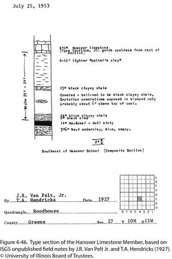
Wanless (1956, 1957) located the section on a tributary of Bear Creek in the NE¼ SW¼ of sec. 27, T 10 N, R 11 W, Greene County, western Illinois, on the Daum 7.5' quadrangle. No description has been published. Field notes in the ISGS Library indicate that the outcrop is slightly east of the spot Wanless specified, in the SW¼ NW¼ SE¼ of sec. 27. S.E. Ekblaw (notes dated September 8, 1930) provided the following description:
| 4'± | Hanover Limestone Member, brownish to bluish gray, nodular structure with brecciated character, massive, in one or two beds. Abundant blue-gray to black nodules in places. Fossils include crinoids, Composita, Squamularia, fusulinids. |
| 8" | Shale, greenish gray, slightly calcareous. |
| 2'± | Covered |
| 6" | Clay-shale, bluish gray, noncalcareous. |
| 2" | Shale, coaly. |
| 2½" | Clay shale, dark bluish-gray, noncalcareous, poorly bedded, very slickensided, no fossils. |
| 1'6" to 2'8" | Houchin Creek Coal Member |
| 1' | Claystone, black, shaly, leafy. |
| 2" | Claystone, gray, noncalcareous. |
| 2' | Shale, gray, noncalcareous, evenly bedded, fern leaf and stem impressions. |
As Ekblaw indicated, approximately 3.5 ft (1.1 m) of poorly exposed shale separates the Houchin Creek Coal from the type Hanover Limestone. However, another version of the section (Figure 4-46) by Van Pelt and Hendricks shows “maybe 20 to 24 feet” (6 to 7 m) of incompletely exposed shale and claystone between coal and limestone. There is a question of whether Ekblaw observed the same limestone as Van Pelt and Hendricks. The need for a reference section is apparent.
Type author(s)
Wanless (1956, 1957).
Type status
Unknown.
Reference section
Reference location
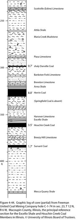
Freeman United Coal Mining Company, borehole C-1-74 (Crown II Mine production shaft), located sec. 23, T 12 N, R 6 W, Macoupin County, ISGS county no. 21495. The core description by M.E. Hopkins and R.B. Nance of the ISGS is on file. The Hanover Limestone Member is 0.7 ft (21 cm) thick and lies at 352.0 to 352.7 ft (107.3 to 107.5 m; Figure 4-44). The same core is the reference section for the Houchin Creek Coal and Excello Shale Members.
Reference author(s)
Present report.
Reference status
Core is available at the ISGS Geological Samples Library (storage number C-10215). The core description is on file at the ISGS Geological Records Unit and is available on the ISGS website.
Stratigraphic relationships
The Hanover Member overlies the Excello Shale and underlies the newly named Delafield Member except very locally, where younger units are in erosional contact with the Hanover.
Extent and thickness

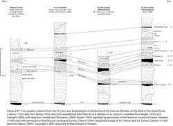
The Hanover occurs sporadically throughout the Illinois Basin. No isopach map is known. In a sampling of core records from Illinois and western Kentucky, the limestone was absent in 22 out of 50 cases (44%). The Hanover was thicker than 2 ft (60 cm) in only two cores. The normal thickness ranges from a few inches (centimeters) to a little more than 1 ft (~10 to 40 cm). Hanover Member thicker than 3.3 ft (1.0 m) is confined to small areas on the Western Shelf of the Illinois Basin. The record thickness is 11 ft (3.3 m) on the flank of the Ozark Dome in the Millstadt Quadrangle, western St. Clair County. Four composite columns from the St. Louis area (Figure 4-47) show that the Hanover Limestone extends farther up the flank of the Ozark Dome than does the Excello Shale or Houchin Creek Coal. Moreover, the limestone is considerably thicker on the flank of the dome than in the deep basin.
An “environmental” map of the Hanover/Blackjack Creek Limestone by Weiner (1961) shows “normal marine limestone” throughout the Midcontinent and western Illinois, with “delta mud” encroaching in a highly lobate pattern through the remainder of the Illinois Basin. Weiner apparently mapped “delta mud” where shale occupies the Hanover position.
Lithology
Except along the western margin of the Illinois Basin, the Hanover Limestone is argillaceous lime mudstone to skeletal wackestone that is dark gray to nearly black, grading to fossiliferous shale with lenses or nodules of limestone. Bioclasts are chiefly brachiopods, echinoderm fragments, bryozoans, bivalves, and gastropods. Shells are commonly unbroken and crinoid stems are partly articulated. Along the western basin margin, the Hanover becomes light-colored microgranular dolomite that weathers buff to yellowish orange, is sparsely fossiliferous, and has pedogenic breccia in the upper part.
Core(s)
Photograph(s)
Contacts
Both contacts are sharp or rapidly gradational. Wanless (1939, 1957) alluded to “hummocky” or “knobby” contacts at some sites in western Illinois where the unit is thicker than usual.
Well log characteristics
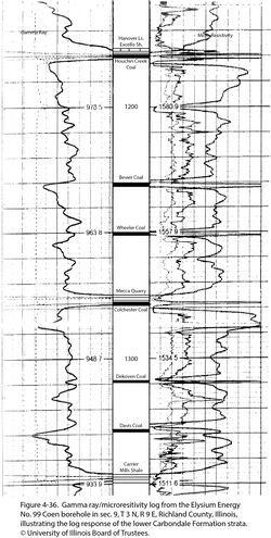
Typical for limestone, but the Hanover is commonly too thin to register on logs. It seems to be responsible for the upper “kick” of the double-peaked or bird’s-beak signature of the Houchin Creek interval on resistivity logs (Figure 4-36).
Fossils
The fauna has been little studied. S.E. Ekblaw (1930, field notes) listed crinoids, fusulinids, and the brachiopods Composita and Squamularia at the type locality, where the limestone is about 4 ft (1.2 m) thick. Wanless (1957, 1958) noted the brachiopod Marginifera along with fusulinids of Fusulina sp. (now Beedeina sp.) at one locality and Orbiculoidea and shark remains. In the Millstadt Quadrangle of St. Clair County, where the Hanover attains a thickness of 11 ft (3.3 m), it contains a diverse marine fauna. Large productid brachiopods are dominant, but bivalves, fenestrate and encrusting bryozoans, echinoderms, and fusulinids also are numerous. Rubey (1952) reported the demosponge Chaetetes along with crinoids, brachiopods, and petrified wood in Calhoun and Jersey Counties. The Blackjack Creek Limestone in Missouri yields a similar assemblage.
Age and correlation
No biostratigraphic analysis of the Hanover has been carried out. Based on the relationship to the Excello Shale, the Blackjack Creek Limestone of the Midcontinent is a direct correlative.
Environments of deposition
Similar to the Oak Grove and St. David Members, the Hanover is better developed on the Western Shelf than in the deeper areas of the Illinois Basin. Waters on the shelf were shallower, probably warmer, better agitated, and well within the photic zone, promoting carbonate precipitation. The Western Shelf also received less of the clastic sediment that is detrimental to filter feeders. The fact that the limestone extends farther up the shelf than do the underlying black shale and coal is consistent with the limestone forming during highstand to early regressive phases of a eustatic cycle. The conglomeratic and brecciated texture in the upper Hanover attests to at least partial and periodic subaerial exposure. In contrast, the eastern and southern parts of the basin were deeper, below the normal wave base and perhaps below the storm wave base. Colder, deeper water, less light input, and a steady rain of clastic detritus suppressed carbonate production.
Economic importance
None.
Remarks
References
- Cline, L.M., 1941, Traverse of upper Des Moines and lower Missouri Series from Jackson County, Missouri to Appanoose County, Iowa: American Association of Petroleum Geologists Bulletin, v. 25, p. 23–72.
- Gentile, R.J., and T.L. Thompson, 2004, Paleozoic succession in Missouri, Part 5, Pennsylvanian Subsystem, Volume A, Morrowan strata through Cherokee Group: Missouri Geological Survey, Report of Investigations 70, 241 p. and correlation chart.
- Knight, J.B., 1933, The location and areal extent of the Saint Louis Pennsylvanian outlier: American Journal of Science, v. 25, p. 25–48 and 166–178.
- Lamar, J.E., H.B. Willman, C.F. Fryling, and W.H. Voskuil, 1934, Rock wool from Illinois mineral resources: Illinois State Geological Survey, Bulletin 61, 262 p.
- Nelson, W.J., 2005, Bedrock geology of Freeburg Quadrangle, St. Clair County, Illinois: Illinois State Geological Survey, Illinois Preliminary Geologic Map IPGM Freeburg-BG, 2 sheets, 1:24,000; 9-p. pamphlet.
- Rubey, W.W., 1952, Geology and mineral resources of the Hardin and Brussels Quadrangles (in Illinois): U.S. Geological Survey, Professional Paper 218, 179 p., 2 pls., 1:62,500.
- Searight, W.V., 1959, Pennsylvanian (Desmoinesian) of Missouri, Geological Society of America Annual Meeting field trip guidebook: Missouri Geological Survey, Report of Investigations 25, 46 p.
- Shaver, R.H., Ann M. Burger, G.R. Gates, H.H. Gray, H.C. Hutchison, S.J. Keller, J.B. Patton, C.B. Rexroad, N.M. Smith, W.J. Wayne, and C.E. Wier, 1970, Compendium of rock-unit stratigraphy in Indiana: Indiana Geological Survey, Bulletin 43, 229 p., 1 pl.
- Shaver, R.H., C. H. Ault, A.M. Burger, D.D. Carr, J.B. Droste, D.L. Eggert, H.H. Gray, D. Harper, N.R. Hasenmueller, W.A. Hasenmueller, A.S. Horowitz, H.C. Hutchison, B. Keith, S.J. Keller, J.B. Patton, C.B. Rexroad, and C.E. Wier, 1986, Compendium of Paleozoic rock-unit stratigraphy in Indiana—A revision: Indiana Geological Survey, Bulletin 59, 203 p.
- Wanless, H.R., 1939, Pennsylvanian correlations in the Eastern Interior and Appalachian coal fields: Geological Society of America, Special Paper 17, 130 p.
- Wanless, H.R., 1956, Classification of the Pennsylvanian rocks of Illinois as of 1956: Illinois State Geological Survey, Circular 217, 14 p.
- Wanless, H.R., 1957, Geology and mineral resources of the Beardstown, Glasford, Havana, and Vermont Quadrangles: Illinois State Geological Survey, Bulletin 82, 233 p.
- Wanless, H.R., 1958, Pennsylvanian faunas of the Beardstown, Glasford, Havana, and Vermont Quadrangles: Illinois State Geological Survey, Report of Investigations 205, 59 p.
- Weiner, J.L., 1961, Environmental study of stages within the Summum cyclothem of Illinois: Urbana, University of Illinois, M.S. thesis, 31 p.
- Wier, C.E. 1961, Stratigraphy of the Carbondale and McLeansboro Groups in southwestern Indiana: Indiana Geological Survey, unpublished bulletin, 147 p. and unnumbered appendix, http://hdl.handle.net/2022/3612 (accessed October 5, 2020).
ISGS Codes
| Stratigraphic Code | Geo Unit Designation |
|---|---|


