Galatia Channel:Sullivan Channel
Sullivan Channel
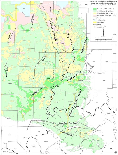
A large paleochannel that interrupts the Springfield Coal in Sullivan and Knox Counties, Indiana (Plate 1), is here named the Sullivan channel. Several previous authors have mapped portions of the Sullivan channel and described some of its effects. Wier and Powell (1967)[1] mapped two elongate areas where the Springfield Coal is absent in Knox County. Eggert (1982, figure 2)[2] showed on a small-scale map “known contemporaneous channels” in Knox and Sullivan Counties and suggested that they join the Galatia channel. Eggert and Adams (1985)[3] discussed these features in more detail. Harper (1988)[4] and Harper and Eggert (1995)[5] presented further maps and information.
Combining information from these sources with newly acquired coal company data, we present a more complete picture of the Sullivan channel (Plate 1). The Sullivan channel is a nearly straight to strongly sinuous belt about 0.6 to 1.6 mi (1 to 2.5 km) wide where clastic rocks occupy the position of the Springfield Coal. Drilling indicates a “precursor” valley filled largely with sandstone and extending as deep as 215 ft (65 m) below the position of the Springfield. This channel truncates the Houchin Creek and Survant Coals, cutting within 15 ft (4.5 m) of the Colchester Coal. Channel filling generally fines upward, grading to siltstone or claystone at the level of the Springfield. These strata are basically identical to the Galatia Member as it occurs in the main Galatia channel.
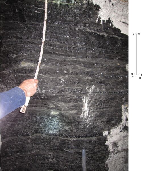
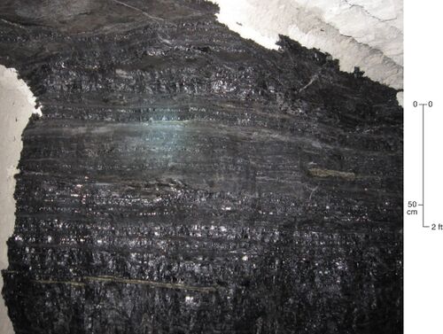
Belts of interlaminated coal and carbonaceous shale, like those found along the Galatia channel, border the Sullivan channel. For example, at the eastern margin of the channel in the Oaktown Mine in Knox County, the Springfield Coal is thicker than 15 ft (4.5 m) but contains approximately 70% carbonaceous shale laminae (Figure 28). Fossil plant stems (Sigillaria) and foliage (Pecopteris, Neuropteris) are abundant in the shale layers. Shale content gradually diminishes eastward, yielding coal with no clastic layers about 5.6 ft (1.7 m) thick at 0.6 mi (1 km) from the channel. The floor also changes from a massive siltstone having few roots and slickensides close to the channel to a well-developed claystone paleosol away from the channel. Shaly coal also occurs along the western margin of the Sullivan channel in the Carlisle Mine, about 9 mi (15 km) north of Oaktown in Sullivan County (Figure 29). As in the Oaktown Mine, shale laminae contain abundant fossil plants, including Calamites stems and broken leaves of Neuropteris and Macroneuropteris. In this same area, the floor of the Springfield consists of laminated shale that contains abundant fossil plants and can be lifted out in large sheets. Core drilling demonstrated that shaly coal borders both sides of the channel in Sullivan County.
Although details are sparse, previous authors (Kottlowski 1954[6]; Wier 1954[7]; Harper 1988[4]; Harper and Eggert 1995[5]) reported that numerous abandoned underground mines encountered areas of “dirty” or “shaly” coal, along with lenses of shale or sandstone, near the margins of the Sullivan channel.
Several sizeable tracts of thick, low-sulfur (0.4% to 1%) coal flank the Sullivan channel. Most of the thickest coal, ranging from 7 to 11 ft (2 to 3 m) thick, occurs in steep-sided structural depressions. As usual, low-sulfur coal is overlain by thick gray shale, siltstone, and sandstone of the Dykersburg Member. The largest of these areas is the Glendora district in northern Sullivan County (Plate 1), where the coal lies in a structural basin about 30 ft (9 m) deep and is topped by up to 30 ft (9 m) of Dykersburg shale and sandstone (Kottlowski 1954[6]; Wier 1954[7]; Harper 1988[4]). Nearly surrounded by thin, shaly coal, the Glendora district appears to lie between branches of the Sullivan channel. The active Carlisle and Oaktown Mines both contain steep-sided troughs where the coal thickens markedly and has a gray, siliciclastic roof. However, in most areas of these mines, the Turner Mine Shale lies directly on the coal.
Thus, the Sullivan channel shares all the attributes of the Galatia channel. The Sullivan is either a direct northward continuation of the Galatia or a major tributary.
Primary Source
References
- ↑ Wier, C.E., and R.L. Powell, 1967, Distribution, structure, and mined coals in Knox County, Indiana: Indiana Geological Survey, Preliminary Coal Map No. 12, 1 sheet.
- ↑ Eggert, D.L., 1982, A fluvial channel contemporaneous with deposition of the Springfield Coal Member (V), Petersburg Formation, northern Warrick County, Indiana: Indiana Geological Survey, Special Report 28, 20 p.
- ↑ Eggert, D.L., and S.C. Adams, 1985, Distribution of fluvial channel systems contemporaneous with the Springfield Coal Member (Middle Pennsylvanian) in southwestern Indiana, in A.T. Cross, ed., Economic geology: Coal, oil and gas: Ninth International Congress of Carboniferous Geology and Stratigraphy, Proceedings, v. 4: Carbondale, Southern Illinois University Press, p. 342–348.
- ↑ a b c Harper, D., 1988, Coal mining in Sullivan County, Indiana: Indiana Geological Survey, Special Report 43, 48 p.
- ↑ a b Harper, D., and D.L. Eggert, 1995, Coal mining in Knox County, Indiana: Indiana Geological Survey, Special Report 54, 23 p.
- ↑ a b Kottlowski, F.E., 1954, Geology and coal deposits of the Dugger Quadrangle, Sullivan County, Indiana: U.S. Geological Survey, Coal Investigations Map C-11, 1 sheet, 1:24,000.
- ↑ a b Wier, C.E., 1954, Geology and coal deposits of the Hymera quadrangle, Sullivan County, Indiana: U.S. Geological Survey, Coal Investigations Map C-16, 1 sheet, 1:24,000.


