Galatia Channel:Houchin Creek Coal: Difference between revisions
Alan.Myers (talk | contribs) No edit summary |
Alan.Myers (talk | contribs) |
||
| Line 6: | Line 6: | ||
Although the Houchin Creek Coal is thick enough to mine only in small areas, it is one of the most laterally extensive coal members in the Illinois Basin. With rare exceptions, the Houchin Creek is a single layer of bright-banded coal, lacking significant clastic layers and resting on well-developed underclay. Pyrite content is normally 3% or higher. Thickness varies from a streak to as much as 5.9 ft (1.8 m), but coal thicker than 3.9 ft (1.2 m) is exceptional, and the usual thickness range is 7.9 to 23.6 in. (20 to 60 cm). The coal occurs throughout the Illinois Basin, except in a few small areas of nondeposition near the northern and western margins, and in other small areas where the coal was eroded in paleochannels. With the overlying Excello Shale and Hanover Limestone, the Houchin Creek forms a package that is readily identified on nearly all types of well logs. A double-peaked or “bird’s beak” profile is characteristic on resistivity logs ([[:File:C605-Figure-05a.jpg|Figure 5a]]). The Houchin Creek evidently represents an in situ peat deposit that developed on a virtually flat, tectonically stable coastal plain of great extent. | Although the Houchin Creek Coal is thick enough to mine only in small areas, it is one of the most laterally extensive coal members in the Illinois Basin. With rare exceptions, the Houchin Creek is a single layer of bright-banded coal, lacking significant clastic layers and resting on well-developed underclay. Pyrite content is normally 3% or higher. Thickness varies from a streak to as much as 5.9 ft (1.8 m), but coal thicker than 3.9 ft (1.2 m) is exceptional, and the usual thickness range is 7.9 to 23.6 in. (20 to 60 cm). The coal occurs throughout the Illinois Basin, except in a few small areas of nondeposition near the northern and western margins, and in other small areas where the coal was eroded in paleochannels. With the overlying Excello Shale and Hanover Limestone, the Houchin Creek forms a package that is readily identified on nearly all types of well logs. A double-peaked or “bird’s beak” profile is characteristic on resistivity logs ([[:File:C605-Figure-05a.jpg|Figure 5a]]). The Houchin Creek evidently represents an in situ peat deposit that developed on a virtually flat, tectonically stable coastal plain of great extent. | ||
<div><ul> | <div><ul> | ||
<li style="display: inline-block;"> [[File:C605-Figure-05a.jpg|thumb|left| | <li style="display: inline-block;"> [[File:C605-Figure-05a.jpg|thumb|left|500px|'''Figure 5a''' Wireline log illustrating the typical response of key units. (a) Electric log of Carter Oil #1 Beers well in Sec. 28, T8S, R4E, Williamson County, Illinois (county no. 2107). (b) Gamma-ray–resistivity log of Peabody Natural Gas #2 Short, in Sec. 14, T7S, R7E, Hamilton County (county no. 25375).]]</li> | ||
</ul></div> | </ul></div> | ||
{{Galatia Channel Page}} | {{Galatia Channel Page}} | ||
Revision as of 18:15, 13 July 2020

Houchin Creek Coal
Although the Houchin Creek Coal is thick enough to mine only in small areas, it is one of the most laterally extensive coal members in the Illinois Basin. With rare exceptions, the Houchin Creek is a single layer of bright-banded coal, lacking significant clastic layers and resting on well-developed underclay. Pyrite content is normally 3% or higher. Thickness varies from a streak to as much as 5.9 ft (1.8 m), but coal thicker than 3.9 ft (1.2 m) is exceptional, and the usual thickness range is 7.9 to 23.6 in. (20 to 60 cm). The coal occurs throughout the Illinois Basin, except in a few small areas of nondeposition near the northern and western margins, and in other small areas where the coal was eroded in paleochannels. With the overlying Excello Shale and Hanover Limestone, the Houchin Creek forms a package that is readily identified on nearly all types of well logs. A double-peaked or “bird’s beak” profile is characteristic on resistivity logs (Figure 5a). The Houchin Creek evidently represents an in situ peat deposit that developed on a virtually flat, tectonically stable coastal plain of great extent.
-
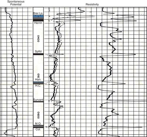 Figure 5a Wireline log illustrating the typical response of key units. (a) Electric log of Carter Oil #1 Beers well in Sec. 28, T8S, R4E, Williamson County, Illinois (county no. 2107). (b) Gamma-ray–resistivity log of Peabody Natural Gas #2 Short, in Sec. 14, T7S, R7E, Hamilton County (county no. 25375).

Primary Source
References