Galatia Channel:Galatia Member
Galatia Member (New)
Name and definition
Hopkins et al. (1979) named the Galatia channel, but the strata that fill the channel have not been formally named. Having a name for these rocks simplifies discussion of the geology. Fortunately, the name “Galatia” is available and is hereby selected. The member takes its name from the town of Galatia in Saline County, Illinois, which is situated directly above the Galatia channel.
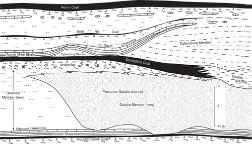
In this report, the Galatia Member of the Carbondale Formation is considered to comprise all rocks that fill channels that cut downward from near the top of the Delafield Member into older strata. These rocks are largely sandstone, but also include siltstone, shale, heterolithic strata, and stringers of coal. Mapping discloses that the Galatia channel of Hopkins et al. (1979) is only one element in a network of paleochannels or incised valleys that traverse a large area of the Illinois Basin. Most of these channels were abandoned and filled prior to Springfield peat accumulation, but the Galatia channel itself remained as an open waterway throughout the time of peat formation. Thus, the Galatia Member is largely older than the Springfield Coal, but the upper part of the member is contemporaneous with the coal within the Galatia channel. Remaining unchanged is the Dykersburg Shale Member (Hopkins 1968), which comprises gray shale, siltstone, and sandstone lying above the Springfield Coal and beneath the black Turner Mine Shale.
Ledvina (1988, p. 638–646) used the name “Galatia Sandstone Member” for sandstone within the Galatia channel and also for lenses or tongues of sandstone within the Dykersburg Shale. However, because Ledvina’s work was never published, it did not enter the U.S. Geological Survey stratigraphic lexicon, so it does not conflict with our definition of the Galatia Member. Lenses of sandstone within the Dykersburg are here considered simply part of the Dykersburg. Eggert (1982) named the fill of a paleochannel that splits the Springfield Coal in Indiana the Folsomville Member. As used by Eggert, the Folsomville is entirely within the Springfield Coal, whereas our Galatia Member is both older than and contemporaneous with the Springfield. In addition, Eggert’s Folsomville Member is restricted to a single paleochannel, the Leslie Cemetery channel. Thus, the Folsomville and Galatia Members are separate entities. The Leslie Cemetery channel is discussed at greater length in a later section of this report.
Type section
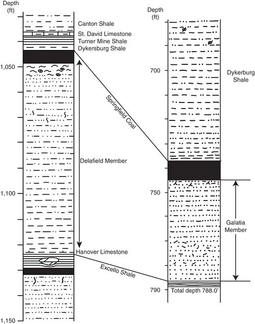
As a type section, the core from Kerr-McGee borehole #7629-16 is hereby selected. The hole was drilled about 4.0 mi (6.5 km) northeast of Galatia in Sec. 29, T7S, R6E, Saline County (county no. 26537). Core from #7629-16 was logged by ISGS geologists and is stored in its entirety at the ISGS Samples Library in Champaign (storage number C-14933). Complete logs and other data for this hole are filed in the ISGS Geologic Records Unit and are available via the ISGS website. The Galatia Member in the type core extends from the depth of 745.4 to 786.0 ft (227.2 to 240.0 m), making the unit 40.6 ft (12.4 m) thick (Figure 6, Appendix C).
Lithology
The Galatia Member is an upward-fining succession, commonly 65 to 100 ft (20 to 30m) thick (Figure 6). The lower part is dominantly sandstone. As seen in cores, the sandstone is very fine to fine-grained, locally medium-grained, overall fining upward. Cross-bedding in the lower part gives way upward to rippled, wavy, and contorted or slumped laminations. Layers of shale-pebble conglomerate occur in the lower part. Also present are siderite pebbles and fragments and stringers of coal. Upper channel filling consists of laminated to massive siltstone and silty shale or mudstone containing carbonaceous flakes and scattered plant fragments. Several cores showed rhythmic lamination, with probable neap-spring tidal cycles, near the top of the member. The uppermost part of the Galatia Member, lateral to the Springfield Coal, is largely dark, carbonaceous shale and claystone containing numerous ragged layers and stringers of coal.
Contacts
The lower contact is erosive, cutting into the Delafield Member and locally into older units, including the Houchin Creek Coal. This erosive basal contact is readily apparent in cores and in most geophysical logs. The upper contact with the Dykersburg Shale is at least locally erosive, as shown by drill cores and underground exposures in the now-abandoned Galatia mine. Because upper Galatia and Dykersburg Members contain similar rock types, this contact can be difficult to pick in well logs. Lacking lithologic evidence, the contact may be mapped at the elevation of the top of the coal adjacent to the channel.
Thickness and distribution
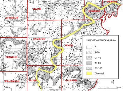
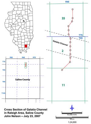
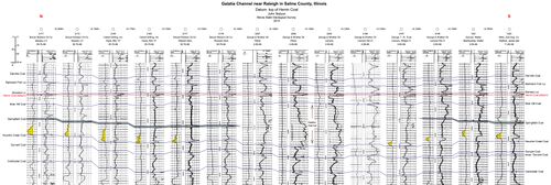
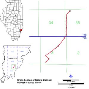
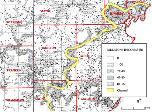
Maps by Potter (1962, 1963), published before the Galatia channel was recognized, portray the thickness of sandstone between the Springfield and Houchin Creek Coals (Figure 8). The sandstone that Potter mapped is largely the Galatia Member of this report. Potter’s 1962 map covers southeastern Illinois at a scale of about 1:250,000, whereas his 1963 map includes parts of Indiana and Kentucky at a smaller scale. An independently prepared map by Wanless et al. (1970, Figure 6) shows a closely similar pattern of sandstone distribution. In addition, Hopkins (1968, Plate 2) published two cross sections of the Galatia channel. Our own cross sections (Plate 2,Plate 2 map overview and Plate 3,Plate 3 map overview) show similar relationships.
Maps portray elongate bodies of sandstone having looping, arcuate boundaries and forming a semidendritic pattern. Cross sections illustrate broad sand-filled channels or valleys that were eroded from near the top of the Delafield Member. These valleys have steep sides and broad, nearly flat bottoms.
Interpretation
Maps and sections portray a series of actively meandering, laterally migrating fluvial channels. Superimposed onto Potter’s map of sandstone thickness, the Galatia channel of Hopkins (1968) coincides with a large, southwest-trending sandstone meander belt (Figure 8). Therefore, this meander belt appears to have been a direct precursor to the Galatia channel that flowed through the Springfield peat swamp. The Galatia precursor channel is the work of a river that flowed across the emerging coastal plain prior to peat accumulation. Eroding soft sediments on a low gradient, this river freely meandered and carried a large sediment load, derived partly from upland sources and partly from recycling its own banks and bed. A broad, sandy meander belt was rapidly established. Through time, the valley aggraded and stream energy declined, reducing the sediment load. Tidal influence became evident in the late stage of channel filling.
Table A2 Type section of the Galatia Member (new)
| Table A2 Type section of the Galatia Member (new) | |||
|---|---|---|---|
| Thickness (ft) | Top depth | Bottom depth | Rock description |
| 8.7 | 736.5 | 745.2 | Springfield Coal (core removed by company; depths from other logs). |
| 0.2 | 745.2 | 745.4 | Coal and shale interlaminated, lower contact sharp and uneven. |
| 3.6 | 745.4 | 749.0 | Top of Galatia Member, sandstone, light olive gray, very fine grained, argillaceous; root traces throughout, masses of granular siderite near base. Lower contact gradational. |
| 5.0 | 749.0 | 754.0 | Siltstone, light olive-gray, coarse (almost sandstone), moderately fissile, lenses and nodules of siderite common. Lower contact gradational. |
| 8.5 | 754.0 | 762.5 | Sandstone, medium-light gray, very fine grained, sublitharenite, portions show faint wavy silt and clay laminae, a few siderite lenses. Lower contact gradational. |
| 6.5 | 762.5 | 769.0 | Siltstone and sandstone, interlayered, lithologies as above. Lamination mostly lenticular and wavy, locally contorted. Rip-up clasts of siltstone in sandstone matrix become more numerous downward. Irregular masses of siderite common. Lower contact gradational. |
| 17.0 | 769.0 | 786.0 | Sandstone, light gray, very fine to fine-grained, litharenite, micaceous. Shale-pebble conglomerate common in upper 11 feet [3.4 m]. Plant fossils in siltstone at 770.0–770.9 ft [234.7 to 235.0 m]. Basal 6 ft is clean, massive sandstone Lower contact erosional. Base of Galatia Member (thickness 40.6 feet) |
| 2.0 | 786.0 | 788.0 | Excello Shale Member, black, hard, thinly fissile, phosphatic lenses and laminae; dense dolomite concretion in mid-lower part. |
| 788.0 | End of core, total depth. | ||
Primary Source
References
- ↑ Potter, P.E., 1962, Shape and distribution patterns of Pennsylvanian sand bodies in Illinois: Illinois State Geological Survey, Circular 339, 36 p., 3 pls.
- ↑ Hopkins, M.E., 1968, Harrisburg (No. 5) Coal reserves of southeastern Illinois: Illinois State Geological Survey, Circular 431, 25 p., 2 pl.
